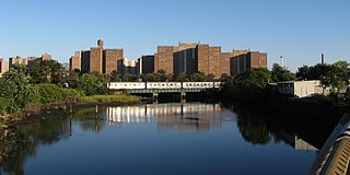
Coney Island Creek is a 1.8-mile-long (2.9 km) tidal inlet in Brooklyn, New York City. It used to be a 3-mile-long (4.8 km) continual strait and a partial mudflat connecting Gravesend Bay and Sheepshead Bay, making Coney Island an actual island, but the eastern half of the creek was filled in by land owners and city construction projects during a period spanning the early to mid 20th century.
Howard Beach is a neighborhood in the southwestern portion of the New York City borough of Queens. It is bordered to the north by the Belt Parkway and Conduit Avenue in Ozone Park, to the south by Jamaica Bay in Broad Channel, to the east by 102nd–104th Streets in South Ozone Park, and to the west by 75th Street in East New York, Brooklyn. The area consists mostly of low-rise single-family houses.

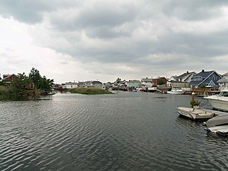
Gerritsen Beach is a neighborhood in the New York City borough of Brooklyn, located between Sheepshead Bay to the west and Marine Park to the east. The area is served by Brooklyn Community Board 15. The population of the neighborhood is 8,353 as of the 2010 U.S. census.

Upper Manhattan is the most northern region of the New York City Borough of Manhattan. Its southern boundary has been variously defined, but some of the most common usages are 96th Street, the northern boundary of Central Park, 125th Street or 155th Street.

South Brooklyn is a historic term for a section of the former City of Brooklyn – now the New York City borough of Brooklyn – encompassing what are now the Boerum Hill, Carroll Gardens, Cobble Hill, Gowanus, Park Slope, Windsor Terrace, Sunset Park and Red Hook neighborhoods. It was named for its location along the waterfront that was the southern border of the original Village of Brooklyn, and has remained widely used as a colloquialism despite it no longer being the southernmost point of the borough. It should not be confused with the geographic southern region of the modern borough of Brooklyn, which includes the neighborhoods of Gravesend, Seagate, Coney Island, Brighton Beach, Manhattan Beach, Sheepshead Bay, Gerritsen Beach, Marine Park, Mill Basin, and Bergen Beach.

The Far Rockaway Branch is an electrified rail line and service owned and operated by the Long Island Rail Road in the U.S. state of New York. The branch begins at Valley Interlocking, just east of Valley Stream station. From Valley Stream, the line heads south and southwest through southwestern Nassau County, ending at Far Rockaway in Queens, thus reentering New York City. LIRR maps and schedules indicate that the Far Rockaway Branch service continues west along the Atlantic Branch to Jamaica. This two-track branch provides all day service in both directions to the Atlantic Terminal in Brooklyn, with limited weekday peak service to/from Penn Station in Midtown Manhattan. During peak hours, express service may bypass Jamaica station.

Zabar's is an appetizing store at 2245 Broadway and 80th Street, on the Upper West Side of Manhattan in New York City, founded by Louis Zabar and Lillian Zabar. It is known for its selection of bagels, smoked fish, olives, and cheeses.

Hammels is an area within Rockaway Beach on the Rockaway Peninsula in the New York City borough of Queens. It is located west of Arverne and east of Seaside, and is centered on Beach 84th Street. Its main thoroughfare is Beach Channel Drive. The New York City Subway's A train travels through the neighborhood on the IND Rockaway Line. The Hammel Houses, a public housing project built in 1954, is located in the neighborhood.
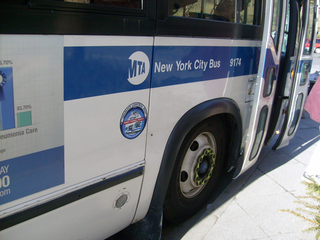
MTA Regional Bus Operations operates local and express buses serving New York City in the United States out of 29 bus depots. These depots are located in all five boroughs of the city, with one located in nearby Yonkers in Westchester County. 21 of these depots serve MTA New York City Transit (NYCT)'s bus operations, while the remaining eight serve the MTA Bus Company. These facilities perform regular maintenance, cleaning, and painting of buses, as well as collection of revenue from bus fareboxes. Several of these depots were once car barns for streetcars, while others were built much later and have only served buses. Employees of the depots are represented by local divisions of the Transport Workers Union of America (TWU), particularly the TWU Local 100 and 101, or of the Amalgamated Transit Union (ATU)'s Local's 726 for all depots in Staten Island, 1056 for Casey Stengel, Jamaica, and Queens Village Depots, and 1179 for JFK & Far Rockaway Depots.
Westchester Creek is a tidal inlet of the East River located in the south eastern portion of the Bronx in New York City. It is 2.1 miles (3.39 km) in length. The creek formerly traveled further inland, to what is now Pelham Parkway, extending almost to Eastchester Bay and making Throggs Neck into an island during heavy storms. However, much of the route has been filled in, replaced by such structures as the New York City Subway's Westchester Yard and the Hutchinson Metro Center. Westchester Creek's present-day head is at Herbert H. Lehman High School; the remaining portion is largely inaccessible and surrounded by industrial enterprises or empty lots. Westchester Creek is traversed by the Bruckner Interchange at about its midpoint.

Paerdegat Basin is a channel that connects to Jamaica Bay between the neighborhoods of Bergen Beach and Canarsie in southeast Brooklyn, New York, United States. It connects to Jamaica Bay to the south, and the north end of the basin is adjacent to the intersection of Ralph Avenue and Flatlands Avenue. "Paerdegat" derives from the old Dutch paardengat, meaning "horse gate".
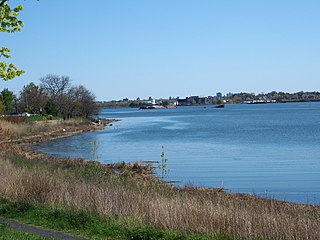
Bowery Bay is a bay off the East River in New York City. It is located near the Steinway neighborhood of Queens and is bordered on the west by the Bowery Bay Water Pollution Control Plant and on the south and east by LaGuardia Airport.

The Brighton Beach Race Course was an American Thoroughbred horse racing facility in Brighton Beach, Brooklyn, New York, opened on June 28, 1879 by the Brighton Beach Racing Association. Headed by real estate developer William A. Engeman, who owned the Brighton Beach Hotel, the one-mile race track was located in back of the hotel and bounded by Ocean Parkway on the west, Neptune Avenue on the north, Coney Island Avenue on the east, and Brighton Beach Avenue on the south. An instant success, the race track drew wealthy patrons from New York City, and harness racing was introduced there in 1901.

Piping Rock Club is a country club in Locust Valley, New York.

Howard was a former Long Island Rail Road station on the Rockaway Beach Branch. Located on marshland along the coast of Jamaica Bay south of the "WD Tower" near Hawtree Creek, it had no fixed address, and was south of what is today 165th Avenue, evidently within the Gateway National Recreation Area's Hamilton Beach Park.
Mussel Island was an island in Newtown Creek located near its confluence with Maspeth Creek, between the Brooklyn neighborhood of Greenpoint and the Queens neighborhood of Maspeth in New York City.

Mill Pond Park is a public park in the Bronx, New York City. It was built to compensate for the loss of parkland resulting from the construction of new Yankee Stadium between 2006 and 2009. The park’s name was inspired by a dam near the site of a creek that emptied into the Harlem River.

Albemarle Hotel was located at 1101 Broadway in the Flatiron District of Manhattan, New York City. Built in 1860 and overlooking Madison Square, it was one of the largest hotels on the avenue in its day.
Book Row was a district in New York City from the 1890s to the 1960s composed of six city blocks which, at its peak, contained over three dozen bookstores. Many – if not most – of the places were used bookstores. In its heyday, Book Row spanned the stretch of Park Avenue between Union Square and Astor Place. Other names for it included "Booksellers' Row" and "Second-Hand Row."
