Raritan Bay

Last updated

Raritan Bay
Wpdms usgs photo raritan bay.jpg
Raritan Bay is shown as highlighted area south of Lower New York Bay and north of Monmouth County.
Location map of Monmouth County, New Jersey.svg
Red pog.svg
Raritan Bay
Coordinates 40°29′00″N74°10′59″W / 40.48333°N 74.18306°W / 40.48333; -74.18306
Part of New York Bight
Primary inflows
Ocean/sea sources Atlantic Ocean
Basin  countriesUnited States
Max. length9 miles (14 km) [1]
Max. width12 miles (19 km) [1]
Surface area69,188 acres (27,999 ha) [1]
Average depth11–30 feet (3.4–9.1 m) [1]
Max. depth45 feet (14 m) [1]
Residence time 60 tidal cycles [2]
Salinity 12-32 ppt [2]
Settlements

Raritan Bay is a bay located at the southern portion of Lower New York Bay between the U.S. states of New York and New Jersey and is part of the New York Bight. The bay is bounded on the northwest by New York's Staten Island, on the west by Perth Amboy, New Jersey, on the south by the Raritan Bayshore communities in the New Jersey counties of Middlesex and Monmouth, and on the east by Sandy Hook Bay. The bay is named after the Raritans, a branch of the Lenape tribe who lived in the vicinity of the bay and its river for thousands of years, prior to the arrival of Dutch and English colonists in the 17th century.

Contents

History

Archeological evidence suggests that humans were already in the region at the close of the Pleistocene. The early "Big Game Hunters" vanished, but the coastal regions were resettled by peoples accustomed to village-style living ("tidewater communities") that subsisted on hunting and gathering marine shellfish, and eventually, on agriculture. In pre-Columbian times "woodlands cultures" probably centered in the Ohio Valley became the dominant cultural influence in the region. Large shell middens were found around Raritan Bay and on Staten Island, a testament of the utilization of the bay for food by Algonquin Indian tribes (Lenapes) who occupied the area when early Colonialists arrived. Early settlers used these shell piles for road construction and field fertilizer. Tottenville was once well known for its roads paved with oyster shells. [3]

Geology

The south side of Raritan Bay RaritanBay1.JPG
The south side of Raritan Bay

The Raritan River was perhaps the major drainage channel along the ice front throughout the Wisconsin glaciation (Stages 1, 2, 3 and 4). Prior to that time the region drained southward across the saddle between the Atlantic Highlands and the Newark Basin into the Delaware River Valley. This saddle area is a very broad flood plain that preserves river terrace gravels (Pensauken Formation) from the Sangemon Interglacial State (Stage 5), as well as older Pleistocene fluvial deposits (Bridgetown Formation). During the lowstand in sea level caused by the Wisconsin glacier, the Raritan River carved back into its headlands and captured the major drainages from the Newark Basin. [3]

As the Wisconsin glaciers melted, the Flandrian Transgression eventually flooded the deeper valleys of the Hudson, Raritan, and Arthur Kill. During warming at the end of the Pleistocene and Early Holocene, the area encompassing Raritan Bay changed from tundra to a landscape dominated by spruce and pine forests. These forests gradually gave way to the modern deciduous forest in the region by mid-Holocene time. Lagoons and bays in the area around Sandy Hook hosted oysters, hard and soft shell clams, lobsters, blue crabs, and a variety of other invertebrates common in bays in the region today. South of western Long Island, tidal flats and wetlands occupied the margins of a tidal estuary (now submerged by marine waters). Inner Raritan Bay began to fill about 2,500 years ago with large oyster beds forming along the estuarine tributaries. Sea level continued to rise about one foot per century. This rise in sea level has resulted in the landward migration of the shoreline (aided by storm-induced coastal erosion) as much as two miles in some portions of the coast since colonial times. [3]

Economy and ecology

The south coast of Raritan Bay RAritanBAyCOast1.JPG
The south coast of Raritan Bay

The bay supported a lucrative fishing and shellfish industry during the nineteenth and early twentieth centuries, especially oysters, which helped to support a stable population around the bay and aided, in part, to feed the flood of immigration. Stable communities continued to grow and change with new industries supporting a larger population base. Advances in methods of fishing and shellfish collecting resulted in overextraction of these resources from the bay. The peak of the fishing industry occurred in the late 1880s to 1910s.[ citation needed ]

Fishing and farming slowly gave way to industries including ship building, ceramics, chemicals and paint manufacturing, electrolytic copper refining, and petroleum refining. In the Keasbey, New Jersey area, large pits were dug to extract the clays for ceramics and bricks, and huge chemical dumps, fly ash piles, and landfills were created to accommodate the waste from the growing industrial empire. The building of shore management structures (dikes, groins, seawalls), the spraying of DDT (and other pesticides) to control the mosquito problem, the carving of ditches to drain wetlands, the filling of shore lowlands, the channelization of creeks, highway and sewer construction, neighborhood development, and a myriad point and non-point sources of household, automobile, industrial chemicals, and ocean dumping all contributed to growing toxicity of the bay.[ citation needed ]

For most of the 20th century, the shores of Arthur Kill have been home to the largest petroleum importing, refining, and storage facilities on Earth; as a consequence the estuary has been host to major and minor oil spills. In addition, Arthur Kill drains the area encompassing the second largest landfill on Earth (Fresh Kills Landfill). This landfill, and others along the Raritan River, provide an ample supply of leachate to the waterways. Chemical wastes cause stress and disruption of the life cycles of plankton, shellfish and other invertebrates, and the fish, birds, and other wildlife that they support.[ citation needed ]

The result was an ecological disaster. The bay approached sterile conditions at the peak of pollution and algal bloom-induced anoxia. Environmental actions from the 1970s to present have helped slowly bring back sea life, but current conditions pale to the wealth of marine resources of the past; certain species of fish and birds continue to decline, and the introduction of tenacious exotic species from around the world contribute to their decline. As a sign of optimism though, oysters are beginning to naturally reappear in the Hudson River after having vanished completely about the time of World War II. [3]

Regional industrial overdevelopment and other pollution factors have raised PCB levels in the fish catch and prompted government recommendations against its routine consumption. [1] [4]

The bay is crossed by a dredged channel allowing commercial ships to enter the Arthur Kill.[ citation needed ]

Aquatic species

Raritan Bay's fish include striped bass, fluke, winter flounder, bluefish, porgy, black sea bass, smoothhound shark, northern puffer, northern king fish, oyster toadfish, tautog and weakfish. The crustacean species represented include the blue crab, fiddler crab, green crab, horseshoe crab and spider crab. Clams and mussels also live in Raritan Bay.[ citation needed ] The bay is a popular destination for recreational fishing due to its proximity to the densely populated areas of Central Jersey and New York City.[ citation needed ]

See also

Related Research Articles

<span class="mw-page-title-main">Shellfish</span> Culinary and fisheries term for exoskeleton-bearing aquatic invertebrates

Shellfish is a colloquial and fisheries term for exoskeleton-bearing aquatic invertebrates used as food, including various species of molluscs, crustaceans, and echinoderms. Although most kinds of shellfish are harvested from saltwater environments, some are found in freshwater. In addition, a few species of land crabs are eaten, for example Cardisoma guanhumi in the Caribbean. Shellfish are among the most common food allergens.

<span class="mw-page-title-main">Chesapeake Bay</span> Estuary in the U.S. states of Maryland and Virginia

The Chesapeake Bay is the largest estuary in the United States. The Bay is located in the Mid-Atlantic region and is primarily separated from the Atlantic Ocean by the Delmarva Peninsula, including parts of the Eastern Shore of Maryland, the Eastern Shore of Virginia, and the state of Delaware. The mouth of the Bay at its southern point is located between Cape Henry and Cape Charles. With its northern portion in Maryland and the southern part in Virginia, the Chesapeake Bay is a very important feature for the ecology and economy of those two states, as well as others surrounding within its watershed. More than 150 major rivers and streams flow into the Bay's 64,299-square-mile (166,534 km2) drainage basin, which covers parts of six states, New York, Pennsylvania, Delaware, Maryland, Virginia, and West Virginia, and all of Washington, D.C.

<span class="mw-page-title-main">Estuary</span> Partially enclosed coastal body of brackish water

An estuary is a partially enclosed coastal body of brackish water with one or more rivers or streams flowing into it, and with a free connection to the open sea. Estuaries form a transition zone between river environments and maritime environments and are an example of an ecotone. Estuaries are subject both to marine influences such as tides, waves, and the influx of saline water, and to fluvial influences such as flows of freshwater and sediment. The mixing of seawater and freshwater provides high levels of nutrients both in the water column and in sediment, making estuaries among the most productive natural habitats in the world.

<span class="mw-page-title-main">Oyster</span> Variety of families of Mollusc

Oyster is the common name for a number of different families of salt-water bivalve molluscs that live in marine or brackish habitats. In some species, the valves are highly calcified, and many are somewhat irregular in shape. Many, but not all oysters, are in the superfamily Ostreoidea.

<span class="mw-page-title-main">Raritan River</span> Major river in the U.S. state of New Jersey

The Raritan River is a major river of New Jersey. Its watershed drains much of the mountainous area of the central part of the state, emptying into the Raritan Bay on the Atlantic Ocean.

<span class="mw-page-title-main">Long Island Sound</span> Tidal estuary on the U.S. East Coast

Long Island Sound is a marine sound and tidal estuary of the Atlantic Ocean. It lies predominantly between the U.S. state of Connecticut to the north and Long Island in New York to the south. From west to east, the sound stretches 110 mi (180 km) from the East River in New York City, along the North Shore of Long Island, to Block Island Sound. A mix of freshwater from tributaries, and saltwater from the Atlantic Ocean, Long Island Sound is 21 mi (34 km) at its widest point and varies in depth from 65 to 230 feet.

<span class="mw-page-title-main">Arthur Kill</span> Navigational channel of the Port of New York and New Jersey

The Arthur Kill is a tidal strait in the New York–New Jersey Harbor Estuary between Staten Island, New York and Union and Middlesex counties, New Jersey. It is a major navigational channel of the Port of New York and New Jersey.

<span class="mw-page-title-main">Newark Bay</span> Estuary in northeastern New Jersey, US

Newark Bay is a tidal bay at the confluence of the Passaic and Hackensack Rivers in northeastern New Jersey. It is home to the Port Newark-Elizabeth Marine Terminal, the largest container shipping facility in Port of New York and New Jersey, the second busiest in the United States. An estuary, it is periodically dredged to accommodate seafaring ships.

<span class="mw-page-title-main">Lower New York Bay</span> Bay in New York, USA

Lower New York Bay is a section of New York Bay south of the Narrows. The eastern end of the Bay is marked by two spits of land, Sandy Hook, New Jersey, and Rockaway, Queens. The waterway between the spits connects the Bay to the Atlantic Ocean at the New York Bight. Traversing the floor of the Bay southeasterly from the Narrows to the Bight and beyond is Hudson Canyon.

<span class="mw-page-title-main">New York–New Jersey Harbor Estuary</span> One of the most intricate natural harbors in the world

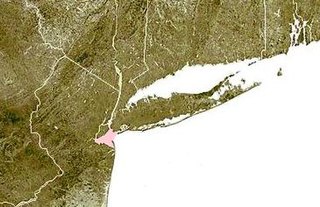
The New York–New Jersey Harbor Estuary, also known as the Hudson-Raritan Estuary, is in the northeastern states of New Jersey and New York on the East Coast of the United States. The system of waterways of the Port of New York and New Jersey forms one of the most intricate natural harbors in the world and one of the busiest ports of the United States. The harbor opens onto the New York Bight in the Atlantic Ocean to the southeast and Long Island Sound to the northeast.

<span class="mw-page-title-main">Marine life of New York–New Jersey Harbor Estuary</span>

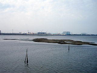
The New York–New Jersey Harbor Estuary has a variety of flora and fauna. Much of the harbor originally consisted of tidal marshes that have been dramatically transformed by the development of port facilities. The estuary itself supports a great variety of thriving estuarine aquatic species; contrary to popular stereotypes, New York Harbor and its adjacent, interdependent waters are very much alive, and steadily recovering from pollution; ecologically it is true that these waters were once dead or extremely toxic but after 45 years of cleaning the estuary is in a much better state than it has been in a hundred years. Tidal flow occurs as far north as Troy, over 150 miles away. The salt front can reach Poughkeepsie in drought conditions and is present in the lower reaches of the Raritan River for most of the year.

<span class="mw-page-title-main">Shrewsbury River</span> Estuary in New Jersey, United States

The Shrewsbury River is a short stream and navigable estuary. The stream is approximately 8 mi (13 km) long and is located in Central New Jersey.

<span class="mw-page-title-main">Lemon Creek (Staten Island)</span> Urban stream in Staten Island, New York

Lemon Creek is a stream located on the South Shore of Staten Island in New York City. It is one of the few remaining ground-level creeks in New York City.

Oyster farming is an aquaculture practice in which oysters are bred and raised mainly for their pearls, shells and inner organ tissue, which is eaten. Oyster farming was practiced by the ancient Romans as early as the 1st century BC on the Italian peninsula and later in Britain for export to Rome. The French oyster industry has relied on aquacultured oysters since the late 18th century.

<span class="mw-page-title-main">Yaquina Bay</span> Small bay partially within Newport, Oregon, United States

Yaquina Bay is a coastal estuarine community found in Newport, Oregon. Yaquina Bay is a semi-enclosed body of water, approximately 8 km2 (3.2 mi2) in area, with free connection to the Pacific Ocean, but also diluted with freshwater from the Yaquina River land drainage. The Bay is traversed by the Yaquina Bay Bridge.

<span class="mw-page-title-main">Port of New York and New Jersey</span> Port in New York and New Jersey, United States

The Port of New York and New Jersey is the port district of the New York-Newark metropolitan area, encompassing the region within approximately a 25-mile (40 km) radius of the Statue of Liberty National Monument.

<span class="mw-page-title-main">Great Bay (New Jersey)</span> Bay in New Jersey, U.S.

Great Bay is located in southern New Jersey's Atlantic Coastal Plain in Ocean and Atlantic Counties, about ten miles (16 km) north of Atlantic City and is about 5.5 miles northwest of Brigantine, and 5.5 miles southwest of Beach Haven. The Mullica River flows into the bay, and together they form the Mullica River - Great Bay estuary habitat. The bay is connected to the Atlantic Ocean via the Little Egg Inlet. Great Bay is considered one of the least-disturbed marine wetlands habitats in the northeastern United States.

<span class="mw-page-title-main">Netarts Bay</span> Bay in Oregon

Netarts Bay is an estuarine bay on the northern Oregon Coast of the U.S. state of Oregon, located about 5 miles (8.0 km) southwest of Tillamook. The unincorporated community of Netarts is located on the north end of the bay and Netarts Bay Shellfish Preserve, managed by Oregon Department of Fish and Wildlife, is located on the south side of the bay. The sand spit on the west side of Netarts bay is part of Cape Lookout State Park.

<span class="mw-page-title-main">Oyster reef restoration</span> Process of rebuilding or restoring of oyster reefs

Oyster reef restoration refers to the reparation and reconstruction of degraded oyster reefs. Environmental changes, modern fishing practices, over harvesting, water pollution, and other factors, have resulted in damage, disease, and ultimately, a large decline in global population and prevalence of oyster habitats. Aside from ecological importance, oyster farming is an important industry in many regions around the world. Both natural and artificial materials have been used in efforts to increase population and regenerate reefs.

<span class="mw-page-title-main">John's Cove (New Jersey)</span> Cove in Elizabeth, New Jersey, United States

John's Cove is located on the Arthur Kill on the Elizabeth, New Jersey waterfront facing Howland Hook Marine Terminal in Staten Island, New York.

References

  1. 1 2 3 4 5 6 "Raritan Bay - Sandy Hook Bay Complex". nctc.fws.gov. Retrieved October 22, 2016.
  2. 1 2 Frank, Dave. "Geology of National Parks - Geologic History of Raritan Bay". 3dparks.wr.usgs.gov. National Park Service. Retrieved October 22, 2016.
  3. 1 2 3 4 Geologic History of Raritan Bay Archived 2006-09-23 at the Wayback Machine from the U.S. Department of the Interior, U.S. Geological Survey, accessed June 24, 2008
  4. Reynolds, Joe (April 27, 2006). "Don't Eat the Fish: PCBs in the Raritan Bay". Atlantic Herald. Archived from the original on May 9, 2006. Retrieved October 22, 2016.