Newark Bay

Last updated
Newark Bay
Manhattan.jpg
Port Newark is seen in the foreground looking northeast across the bay to Jersey City and the Manhattan borough of New York City.
Location map of Hudson County, New Jersey.svg
Red pog.svg
Newark Bay
USA New Jersey relief location map.svg
Red pog.svg
Newark Bay
Usa edcp relief location map.png
Red pog.svg
Newark Bay
Location New Jersey
Coordinates 40°40′47″N74°07′53″W / 40.679597°N 74.131451°W / 40.679597; -74.131451
Type Bay

Newark Bay is a tidal bay at the confluence of the Passaic and Hackensack Rivers in northeastern New Jersey. It is home to the Port Newark-Elizabeth Marine Terminal, the largest container shipping facility in Port of New York and New Jersey, the second busiest in the United States. An estuary, it is periodically dredged to accommodate seafaring ships.

Contents

Geography

Newark Bay is entered by passing under the Bayonne Bridge Bayon Bridge Map.png
Newark Bay is entered by passing under the Bayonne Bridge

Newark Bay is rectangular, approximately 5.5 miles (8.9 km) long, varying in width from 0.6 to 1.2 miles (0.97 to 1.93 km). [1] It is enclosed on the west by the cities of Newark and Elizabeth, and on the east by Jersey City and Bayonne. At the south is Staten Island, New York and at the north Kearny Point and Droyer's Point mark the mouth of the Hackensack. Shooters Island is a bird sanctuary where the borders of Staten Island, Bayonne and Elizabeth meet at one point. [2] The southern tip of Bergen Neck, known as Bergen Point, juts into the bay and lent its name to the former Bergen Point Lighthouse. Built offshore in 1849 it was demolished and replaced with a skeletal tower in the mid 20th century. [3]

The Atlantic Ocean at Sandy Hook and Rockaway Point is approximately 11 miles (18 km) away and reached by tidal straits dredged to maintain shipping lanes. Newark Bay is connected to Upper New York Bay by the Kill Van Kull and to Raritan Bay by the Arthur Kill. The names of the channels reflect the period of Dutch colonialization. The area around the bay was called Achter Kol, which translates as behind or beyond the ridge and refers to Bergen Hill. The emergence of the Hudson Palisades begins on Bergen Neck, the peninsula between the bay and the Hudson River. Kill in Dutch means stream or channel. During the British colonial era the bay was known as Cull bay. [4] Kill van Kull literally translates as channel from the ridge. Arthur Kill is an anglicization of achter kill meaning back channel, which would speak to its location behind Staten Island.

Many of the maritime and distribution facilities along the bay are part of Foreign Trade Zone 49. [5]

Bridges

Upper Bay Bridge and Newark Bay Bridge. New Jersey Turnpike and Interstate 78. Oak Island Yard and Port Newark in foreground with Bayonne and Staten Island seen in the distance. Bayonne, New Jersey and Staten Island, New York.jpg
Upper Bay Bridge and Newark Bay Bridge. New Jersey Turnpike and Interstate 78. Oak Island Yard and Port Newark in foreground with Bayonne and Staten Island seen in the distance.

The bay is spanned by the Vincent R. Casciano Memorial Bridge which carries the Newark Bay Extension (Interstate 78) of the New Jersey Turnpike. The Upper Bay Bridge is a vertical-lift bridge north of the Casciano that is now used by CSX Transportation for freight shipment, including the notable Juice Train. Central Railroad of New Jersey's Newark Bay Bridge crossed the bay from 1864 to connect its Communipaw Terminal. Last used in 1978, it was determined to be a hazard to maritime navigation and demolished in the 1980s.

Shoreline

Elizabethport to the Ironbound

The CRRNJ Newark Bay Bridge, demolished in the 1980s, crossed to Elizabethport, seen in the distance. Elizabeth across Newark Bay.JPG
The CRRNJ Newark Bay Bridge, demolished in the 1980s, crossed to Elizabethport, seen in the distance.
Bergen Point looking northwest to Elizabeth Marine Terminal Bergen Point barge tow jeh.JPG
Bergen Point looking northwest to Elizabeth Marine Terminal

Elizabeth is the site of the first English speaking European settlement (1675) in New Jersey, its port at the southern end of the bay a major maritime hub during the colonial era. Jersey Gardens, an outlet mall, has been located north of Elizabethport since 1999. There are plans to construct a mixed used community adjacent to it along the bay. [6]

The western edge of Newark Bay was originally shallow tidal wetlands covering approximately 12 square miles (31 km2). In the 1910s, the city of Newark began excavating an angled shipping channel in the northeastern quadrant of the wetland which formed the basis of Port Newark. [7] [8] Work on the channel and terminal facilities on its north side accelerated during World War I, when the federal government took control of Port Newark. During the war there were close to 25,000 troops stationed at the Newark Bay Shipyard. [9] [10]

The city decided to expand the port at the end of the war. [11] The Port Authority of New York and New Jersey was formed in 1921 [12] and the Newark Bay Channels were authorized by the Rivers and Harbors Acts in 1922. Shipping operations languished after the war, and in 1927, the City of Newark started construction of Newark Liberty International Airport on the northwest quadrant of the wetlands which lay between Port Newark and the edge of the developed city. Port Authority took over the operations of Port Newark and the Newark Airport in 1948 and began modernizing and expanding both facilities southward. In 1958, the Port Authority dredged another shipping channel which straightened the course of Bound Brook, the tidal inlet forming the boundary between Newark and Elizabeth. Dredged materials was used to create new upland south of the new Elizabeth Channel, where the Port Authority constructed the Elizabeth Marine Terminal. The first shipping facility to open upon the Elizabeth Channel was the new 90-acre (36 ha) Sea-Land Container Terminal, which was the prototype for virtually every other container terminal constructed thereafter. [13]

The Ironbound is an industrial area along the bay which becomes residential farther inland near Downtown Newark.

Kearny Point

The Central Railroad of New Jersey first built the Newark and New York Railroad across the rivers and tip of New Barbadoes Neck in 1869. One bridge was taken out of service in 1946 after a ship collided into it. Passenger service on the other bridge, the PD Draw, was discontinued in 1967. The Kearny Point peninsula is site of the River Terminal, a massive distribution facility. [14] It comprises the former Western Electric Kearny Works and Federal Shipbuilding and Drydock Company, the shipyards of which operated from 1917 to 1949, and played a prominent role in both World War I and World War II. [15]

Bergen Point to Droyer's Point

The shoreline at Bayonne Decayed pier remnant.JPG
The shoreline at Bayonne

While there was some maritime development on the eastern banks of the bay closer Bergen Point most of the eastern shore abuts residential and recreational areas. The Hackensack RiverWalk is a partially completed linear park greenway intended to link the string of parks along its banks and that of the Hackensack River from the Bayonne Bridge to the Hackensack Meadowlands in Secaucus and North Bergen. In Bayonne, much of the bay has not seen bulkhead development, and hence has a natural shoreline. The city's largest parks are its shores. [16] [17] At Droyer's Point recreational and residential development have included a promenade.

Howland Hook

The Howland Hook Marine Terminal is a container port facility located at the northwestern corner of Staten Island at the entrance to the Arthur Kill. Nearby is Port Ivory, named for the Ivory Soap plant once located there. [18] To the east is the residential neighborhood of Mariners Harbor which overlooks the bay. In the first half of the 20th century, Bethlehem Steel maintained a plant which built military transports during World War I and World War II. [19] [20] Currently, tugboat companies and number of smaller dry docks operate along the shore.

Pollution and marine life

The watershed which drains into the bay Passaicwatershedmap.png
The watershed which drains into the bay

The bay is notoriously polluted, and it is now a Superfund site. "One blue crab in Newark Bay has enough dioxin to give somebody cancer," said David Pringle, spokesman for Clean Water Action. [21]

Both the tributaries, particularly the Passaic River, have sections which are lined with heavy industry. [22] Some industrial facilities discharged wastes into the tributaries during the nineteenth and twentieth centuries, prior to passage of the 1972 Clean Water Act. High levels of PCBs and dioxin have been detected in the bay. It also has high levels of mercury, copper and other toxic chemicals. [23]

While illegal discharges of chemical waste have been stopped, crabbing is illegal and fishing is limited due to chemicals that remain in the sediment. [24] [25]

Pronounced endocrine disruption and reproductive effects have been reported in Newark Bay Mummichog, often used as a sentinel and bioindicator species. [26] Reproductive effects reported are primarily due to a chemical inhibition of vitellogenesis and oogenesis, which are highly conserved processes for oviparous (egg-laying) animals. [27] Killifish within Newark Bay have also been reported to chemically adapt (desensitize) to aryl hydrocarbon receptor mediated pollutants (i.e. dioxins). [28] Killifish within Newark Bay have emerged as a popular tool for studying population effects of historical and emerging chemicals of concern due to their chronic exposure to complex mixtures of common contaminants, and subsequent effects due to living within a polluted environment.

2008 Liberian freighter collision

In January 2008, a 117 ft. Great Lakes Dredge and Dock Company dredge in Newark Bay was struck by a 669-ft Liberian-flagged orange juice freighter named the Orange Sun. Newark Bay had to be closed for five hours by the U.S. Coast Guard until damages to the GLD&D dredge were mitigated. The dredge had begun to take on water and a diving crew was sent in order to make repairs. [29] In December 2009, the National Transportation Safety Board issued a report that blamed the Orange Sun for the accident. The Orange Sun's master had not informed the captain or crew about the ship's tendency to deviate from its course. [30]

See also

Related Research Articles

<span class="mw-page-title-main">Mummichog</span> Species of fish

The mummichog is a small killifish found along the Atlantic coast of the United States and Canada. Also known as Atlantic killifish, mummies, gudgeons, and mud minnows, these fish inhabit brackish and coastal waters including estuaries and salt marshes. The species is noted for its hardiness and ability to tolerate highly variable salinity, temperature fluctuations from 6 to 35 °C, very low oxygen levels, and heavily polluted ecosystems. As a result, the mummichog is a popular research subject in embryological, physiological, and toxicological studies. It is also the first fish ever sent to space, aboard Skylab in 1973.

<span class="mw-page-title-main">New York Harbor</span> Harbor in New York and New Jersey

New York Harbor is at the mouth of the Hudson River where it empties into New York Bay near the East River tidal estuary, and then into the Atlantic Ocean on the United States East coast.

<span class="mw-page-title-main">Arthur Kill</span> Navigational channel of the Port of New York and New Jersey

The Arthur Kill is a tidal strait in the New York–New Jersey Harbor Estuary between Staten Island, New York and Union and Middlesex counties, New Jersey. It is a major navigational channel of the Port of New York and New Jersey.

<span class="mw-page-title-main">Kill Van Kull</span> Tidal strait between Staten Island, New York and Bayonne, New Jersey, United States

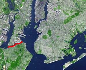
The Kill Van Kull is a tidal strait between Staten Island, New York and Bayonne, New Jersey in the United States. It is approximately 3 miles (4.8 km) long and 1,000 feet (305 m) wide and connects Newark Bay with Upper New York Bay. The Robbins Reef Light is at the eastern end of the Kill, and Bergen Point marks its western end. It is spanned by the Bayonne Bridge and is one of the most heavily traveled waterways in the Port of New York and New Jersey.

<span class="mw-page-title-main">Port Newark–Elizabeth Marine Terminal</span> Major component of the Port of New York and New Jersey

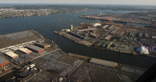
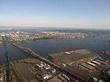
Port Newark–Elizabeth Marine Terminal, a major component of the Port of New York and New Jersey, is the principal container ship facility for goods entering and leaving the New York metropolitan area and the northeastern quadrant of North America. Located on Newark Bay, the facility is run by the Port Authority of New York and New Jersey. Its two components, Port Newark and the Elizabeth Marine Terminal sit side by side within the cities of Newark and Elizabeth, New Jersey, just east of the New Jersey Turnpike and Newark Liberty International Airport.

<span class="mw-page-title-main">New York–New Jersey Harbor Estuary</span> One of the most intricate natural harbors in the world

The New York–New Jersey Harbor Estuary, also known as the Hudson-Raritan Estuary, is in the northeastern states of New Jersey and New York on the East Coast of the United States. The system of waterways of the Port of New York and New Jersey forms one of the most intricate natural harbors in the world and one of the busiest ports of the United States. The harbor opens onto the New York Bight in the Atlantic Ocean to the southeast and Long Island Sound to the northeast.

<span class="mw-page-title-main">Passaic River</span> River in New Jersey, United States

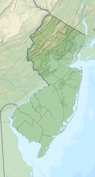
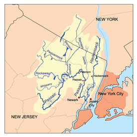
The Passaic River is a river, approximately 80 miles (130 km) long, in Northern New Jersey. The river in its upper course flows in a highly circuitous route, meandering through the swamp lowlands between the ridge hills of rural and suburban northern New Jersey, called the Great Swamp, draining much of the northern portion of the state through its tributaries.

<span class="mw-page-title-main">Hackensack River</span> River in the U.S. states of New York and New Jersey

The Hackensack River is a river, approximately 45 miles (72 km) long, in the U.S. states of New York and New Jersey, emptying into Newark Bay, a back chamber of New York Harbor. The watershed of the river includes part of the suburban area outside New York City just west of the lower Hudson River, which it roughly parallels, separated from it by the New Jersey Palisades. It also flows through and drains the New Jersey Meadowlands. The lower river, which is navigable as far as the city of Hackensack, is heavily industrialized and forms a commercial extension of Newark Bay.

<span class="mw-page-title-main">Central Railroad of New Jersey Terminal</span> Former intermodal terminal in Jersey City, New Jersey

The Central Railroad of New Jersey Terminal, also known as Communipaw Terminal and Jersey City Terminal, was the Central Railroad of New Jersey's waterfront passenger terminal in Jersey City, New Jersey. The terminal was built in 1889, replacing an earlier one that had been in use since 1864. It operated until April 30, 1967.

<span class="mw-page-title-main">Port of New York and New Jersey</span> Port in New York and New Jersey, United States

The Port of New York and New Jersey is the port district of the New York-Newark metropolitan area, encompassing the region within approximately a 25-mile (40 km) radius of the Statue of Liberty National Monument.

<span class="mw-page-title-main">Military Ocean Terminal at Bayonne</span> Former shipping terminal in New Jersey, US

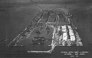
Military Ocean Terminal at Bayonne (MOTBY) was a U.S. military ocean terminal located in the Port of New York and New Jersey which operated from 1967 to 1999. From 1942 to 1967 the site was the Bayonne Naval Drydock. The site is on Upper New York Bay south of Port Jersey on the eastern side of Bayonne, New Jersey. Since its closure, it has undergone maritime, residential, commercial, and recreational mixed-use development. Part of the Hudson River Waterfront Walkway runs along its perimeter.

<span class="mw-page-title-main">Bergen Point</span> Populated place in Hudson County, New Jersey, US

Bergen Point is a point of land that lends its name to the adjacent neighborhood in Bayonne in Hudson County, in the U.S. state of New Jersey. The point is located on the north side of Kill van Kull at Newark Bay. It is the section of the city closest to the Bayonne Bridge. Historically the term has been used more broadly as synonymous with Constable Hook, from which it is geographically separated at Port Johnson.

<span class="mw-page-title-main">Gateway Region</span> Urbanized area of northeastern New Jersey, US

The Gateway Region is the primary urbanized area of the northeastern section of New Jersey. It is anchored by Newark, the state's most populous city. It is part of the New York metropolitan area.

<span class="mw-page-title-main">Bergen Neck</span> Peninsula in northeastern New Jersey, United States

Bergen Neck is the peninsula between the Upper New York Bay and the Newark Bay in the Hudson County, New Jersey municipalities of Bayonne and Jersey City. Its southernmost tip, Bergen Point, is separated from Staten Island by the Kill van Kull, which is crossed by the Bayonne Bridge.

<span class="mw-page-title-main">Port Jersey</span> Freight terminal on Upper New York Bay

Port Jersey, officially the Port Jersey Port Authority Marine Terminal and referred to as the Port Jersey Marine Terminal, is an intermodal freight transport facility that includes a container terminal located on the Upper New York Bay in the Port of New York and New Jersey. The municipal border of the Hudson County cities of Jersey City and Bayonne runs along the long pier extending into the bay.

<span class="mw-page-title-main">Upper Bay Bridge</span> Bridge in Newark and Bayonne, New Jersey

The Upper Bay Bridge, or the Lehigh Valley Railroad Bridge, is a vertical lift bridge spanning the Newark Bay in northeastern New Jersey. It is used by CSX Transportation travelling through the North Jersey Shared Assets Area of the United States rail network along the National Docks Secondary line. The bridge is just north and parallel to the New Jersey Turnpike's Newark Bay Bridge. A notable train using the bridge is the Juice Train, which originates in Florida.

<span class="mw-page-title-main">Newark and New York Railroad</span>

The Newark and New York Railroad was a passenger rail line that ran between Downtown Newark and the Communipaw Terminal at the mouth of the North River in Jersey City, bridging the Hackensack River and Passaic River just north of their mouths at the Newark Bay in northeastern New Jersey. The Central Railroad of New Jersey operated it from its opening in 1869. Though operations ended in 1946; portions remained in use until 1967.

<span class="mw-page-title-main">PD Draw</span> Bridge in Northeastern New Jersey, USA

The PD Draw is a partially dismantled railroad bridge on the Passaic River between Newark and Kearny in the US state of New Jersey. It was built as part of Central Railroad of New Jersey branch known as the Newark and New York Railroad. The swing bridge is the first crossing upstream from Newark Bay at mile point 1.2.

<span class="mw-page-title-main">ExpressRail</span> Intermodal rail facilities at New York Harbor

ExpressRail is a network of on- or near-dock rail yards supporting intermodal freight transport at the major container terminals of the Port of New York and New Jersey. The development of dockside trackage and rail yards for transloading has been overseen by the Port Authority of New York and New Jersey, which works in partnership with other public and private stakeholders. As of 2019, four ExpressRail facilities were in operation, with a total built capacity of 1.5 million lifts.

References

  1. "US Army Corps of Engineers: Newark Bay" (PDF). Archived from the original (PDF) on 2010-05-28. Retrieved 2010-04-18.
  2. Hudson County New Jersey Street Map. Hagstrom Map Company, Inc. 2008. ISBN   978-0-88097-763-0.
  3. Bergen Point Lighthouse, 1849-1949, New Jersey Lighthouse Society.
  4. Grabas, Joseph A. "Land Speculation and Proprietary Beginnings of New Jersey" (PDF). The Advocate. XVI (4): 3, 20, 14. Archived from the original (PDF) on November 20, 2008. Retrieved April 15, 2010.
  5. PANYNJ FTZ 49
  6. $2B MXD Planned for Elizabeth Waterfront Archived 2012-06-12 at the Wayback Machine
  7. "TO MAKE NEWARK BAY A BIG PORT; The Jersey Meadow's Being Transformed Into a Busy Spot, with Docks and Reclaimed Land" (PDF). The New York Times. 27 June 1915.
  8. French, Kenneth (February 24, 2002). Images of America:Railroads of Hoboken and Jersey City. Portsmouth, New Hampshire: Arcadia Publishing. pp. 25–29. ISBN   978-0-7385-0966-2 . Retrieved November 21, 2009.
  9. "Newark Bay Shipyard".
  10. Newark Bay Shipyard
  11. "THE CITY OF NEWARK TO EXPEND $1,250,000 IN THE DEVELOPMENT OF NEWARK BAY AS A SEAPORT; Unwilling in Wait Langer for Government Aid the City Authorities Authorize the Issuance of bonds to Provide Funds for Deepening of Channel to Accommodate the Largest Vessels--Plan Endorsed by Business Men" (PDF). The New York Times. 31 July 1921.
  12. of New York and New Jersey
  13. "History - Port of New York and New Jersey - Port Authority of New York & New Jersey".
  14. River Terminal
  15. Kearny Yard
  16. Hackenack Riverwalk Plan proposal 2003 Archived 2009-09-10 at the Library of Congress Web Archives
  17. Hudson County Master Plan [ permanent dead link ]
  18. "Ongoing Projects :: Port Ivory". Longleaf Lumber. Archived from the original on 2010-10-15. Retrieved 2010-04-15.
  19. Mariners Harbor Shipyard
  20. Bethlehem Shipbuilding: List of Ships built at Staten Island
  21. "Outrage Over Company Backing Out of Superfund Cleanup Through Bankruptcy". NJTV News. 2017-04-18.
  22. "Watershed Database and Mapping Projects/Newark Bay (New Jersey)." National Ocean Service, Office of Response and Restoration. Silver Spring, MD. March 2007.
  23. "Comprehensive Conservation and Management Plan: Management of Toxic Contamination" (PDF). U.S. Environmental Protection Agency (EPA). March 1996.
  24. "Fish Advisories". Trenton, NJ: New Jersey Department of Environmental Protection (NJDEP). 29 May 2009.
  25. "Blue Claw Crab Alert". NJDEP. 2009-12-02.
  26. Bugel, Sean M.; White, Lori A.; Cooper, Keith R. (18 Feb 2010). "Impaired reproductive health of killifish (Fundulus heteroclitus) inhabiting Newark Bay, NJ, a chronically contaminated estuary". Aquatic Toxicology. 96 (3): 182–193. doi:10.1016/j.aquatox.2009.10.016. PMID   20079544.
  27. Bugel, S. M.; White, L. A.; Cooper, K. R. (22 Mar 2011). "Decreased vitellogenin inducibility and 17β-estradiol levels correlated with reduced egg production in killifish (Fundulus heteroclitus) from Newark Bay, NJ". Aquatic Toxicology. 105 (1–2): 1–12. doi:10.1016/j.aquatox.2011.03.013. PMC   4798252 . PMID   21684236.
  28. Prince, Ruth; Cooper, Keith R. (26 Oct 1995). "Comparisons of the effects of 2,3,7,8-tetrachlorodibenzo-p-dioxin on chemically impacted and nonimpacted subpopulations of Fundulus heteroclitus: I. TCDD toxicity". Environmental Toxicology and Chemistry. 14 (4): 579–587. doi:10.1002/etc.5620140405.
  29. "Accident Closes Major Shipping Channel for Hours". The New York Times. 2008-01-25.
  30. "Federal report blames ship carrying orange juice for Newark Bay collision last year". NJ On-Line. 2009-12-09.