The first known European to explore and write about the area was Martin Pring in 1603. The Piscataqua River is a tidal estuary with a swift current, but forms a good natural harbor. The west bank of the harbor was settled by European colonists in 1630 and named Strawbery Banke, after the many wild strawberries growing there. The village was protected by Fort William and Mary on what is now New Castle Island. Strategically located for trade between upstream industries and mercantile interests abroad, the port prospered. Fishing, lumber and shipbuilding were principal businesses of the region.[3]Enslaved Africans were imported as laborers as early as 1645 and were integral to building the city's prosperity.[4] Portsmouth was part of the Triangle Trade, which made significant profits from slavery.
Market Square in 1853Portsmouth Harbor, New Hampshire by William James Glackens (1909)Waterfront, 1917
At the town's incorporation in 1653, it was named "Portsmouth" in honor of the colony's founder, John Mason. He had been captain of the English port of Portsmouth, Hampshire, after which New Hampshire is named.
In 1774, in the lead-up to the Revolution, Paul Revere rode to Portsmouth warning that the BritishRoyal Navy was coming to capture the port.[5] Although Fort William and Mary protected the harbor, the Patriot government moved the capital inland to Exeter, which ensured that it would be under no threat from the Royal Navy, which bombarded Falmouth (now Portland, Maine) instead on October 18, 1775. Portsmouth was the destination for several of Beaumarchais's ships containing materiel, such as artillery, tents, and gunpowder, to help the American revolutionary effort.[6] African Americans helped defend Portsmouth and New England during the war. In 1779, 19 enslaved African Americans from Portsmouth wrote a petition to the state legislature and asked that it abolish slavery, in recognition of their war contributions and in keeping with the principles of the Revolution.[4] The legislature tabled their petition. New Hampshire abolished slavery in 1857, by which time the institution was effectively extinct in the state.
Thomas Jefferson's 1807 embargo against American trade with Britain severely disrupted New England's trade with Canada, and several local businessmen went bankrupt. Portsmouth was host to numerous privateers during the War of 1812. In 1849, Portsmouth was incorporated as a city.[3]
Once one of the nation's busiest ports and shipbuilding cities, Portsmouth expressed its wealth in fine architecture. It has significant examples of Colonial, Georgian, and Federal style houses, some of which are now museums. Portsmouth's heart has stately brick Federalist stores and townhouses, built all-of-a-piece after devastating early 19th-century fires. The worst was in 1813 when 244 buildings burned.[3] A fire district was created that required all new buildings within its boundaries to be built of brick with slate roofs; this created the downtown's distinctive appearance. The city was also noted for the production of boldly wood-veneered federal-style (neoclassical) furniture, particularly by the master cabinet maker Langley Boardman.
In the 20th century, the city founded a Historic District Commission, which has worked to protect much of the city's irreplaceable architectural legacy. In 2008, the National Trust for Historic Preservation named Portsmouth one of the "Dozen Distinctive Destinations".[7] The compact and walkable downtown on the waterfront draws tourists and artists, who each summer throng the cafes, restaurants and shops around Market Square. Portsmouth annually celebrates the revitalization of its downtown (in particular Market Square) with Market Square Day,[8] a celebration dating back to 1977, produced by the non-profit Pro Portsmouth, Inc.
This emphasis on historic preservation and revitalization was the result of much pain and destruction. Portsmouth is largely walkable due to its network of streets and tight blocks filled with preserved Revolution-era homes. However, like many other cities all over the region (and nation), Portsmouth was hit by Urban Renewal, a planning tool used nationwide to provide Federal funds to address “urban blight” and revitalize downtown cores after decades of suburbanization and loss of tax revenue. An urban renewal district for Portsmouth was its North End neighborhood, which similar to Boston’s, was home to an Italian-American population.[9]
In 1964, federal funds were allocated to the North End project area in Portsmouth, for urban renewal. Prior to redevelopment, the North End was a mix of residential and commercial buildings, with many older houses converted into storefronts with apartments above. In the mid-1960s, the area was considered overcrowded, run down, and a fire hazard. As a result, the Portsmouth Housing Authority proposed the destruction of approximately 200 buildings, a school, and a church and redevelopment for commercial, industrial, and public use, rather than for residences. The project would displace approximately 300 families as a result. In 1968, Portsmouth Preservation Inc., a preservation organization was formed to attempt to save some of the historic building stock in the area slated for redevelopment. After bitter fighting and preservation advocacy, just fourteen houses were saved and mostly moved to an area known today as “The Hill”.[10] This preservation was only the beginning, and eventually efforts conspired to created the afformentioned historic district. Urban renewal was many events that led to its creation.
Portsmouth shipbuilding history has had a long symbiotic relationship with Kittery, Maine, across the Piscataqua River. In 1781–1782, the naval hero John Paul Jones lived in Portsmouth while he supervised construction of his ship Ranger, which was built on nearby Badger's Island in Kittery. During that time, he boarded at the Captain Gregory Purcell house, which now bears Jones' name, as it is the only surviving property in the United States associated with him. Built by the master housewright Hopestill Cheswell, an African American,[11] it has been designated as a National Historic Landmark. It now serves as the Portsmouth Historical Society Museum.
The Portsmouth Naval Shipyard, established in 1800 as the first federal navy yard, is on Seavey's Island in Kittery, Maine.[12] The base is famous for being the site of the 1905 signing of the Treaty of Portsmouth[13] which ended the Russo-Japanese War. Though US President Theodore Roosevelt orchestrated the peace conference that brought Russian and Japanese diplomats to Portsmouth and the Shipyard, he never came to Portsmouth, relying on the Navy and people of New Hampshire as the hosts. Roosevelt won the 1906 Nobel Peace Prize for his diplomacy in bringing about an end to the war.
Geography
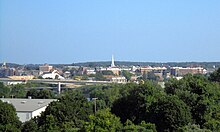
Portsmouth downtown from I-95
According to the United States Census Bureau, the city has a total area of 16.8 square miles (43.6km2), of which 15.7 square miles (40.6km2) are land and 1.2 square miles (3.0km2), or 6.92%, are water.[14] Portsmouth is drained by Berrys Brook, Sagamore Creek and the Piscataqua River, which is the boundary between New Hampshire and Maine. The highest point in the city is 110 feet (34m) above sea level, within Pease International Airport.
Climate
Portsmouth has a humid continental climate[15] (Dfb) in spite of its maritime position, due to prevailing inland winds. Summers are moderately warm with winter days averaging around the freezing point, but with cold nights bringing it below the required −3°C (27°F) isotherm to have a humid continental climate. With high year-round precipitation, the cold winters can often be very snowy and summers wet.[16]
Portsmouth is the sole city in Rockingham County, but the fourth-largest municipality, with fewer people than the towns of Derry, Londonderry, and Salem.
As of the census of 2010, there were 21,233 people, 10,014 households, and 4,736 families residing in the city. The population density was 1,361.1 peopleper square mile (525.5 people/km2). There were 10,625 housing units at an average density of 681.1 per square mile (263.0/km2). The racial makeup of the city was 91.5% White, 1.7% African American, 0.2% Native American, 3.5% Asian, 0.01% Pacific Islander, 0.7% some other race, and 2.3% from two or more races. Hispanic or Latino of any race were 2.8% of the population.[20]
There were 10,014 households, out of which 20.2% had children under the age of 18 living with them, 35.5% were headed by married couples living together, 8.3% had a female householder with no husband present, and 52.7% were non-families. 39.2% of all households were made up of individuals, and 11.8% were someone living alone who was 65 years of age or older. The average household size was 2.03, and the average family size was 2.75.[20]
In the city, the population was spread out, with 16.6% under the age of 18, 7.7% from 18 to 24, 32.2% from 25 to 44, 27.6% from 45 to 64, and 15.9% who were 65 years of age or older. The median age was 40.3 years. For every 100 females, there were 94.2 males. For every 100 females age 18 and over, there were 92.6 males.[20]
For the period 2010–2014, the city's estimated median annual household income was $67,679, and the median family income was $90,208. Male full-time workers had a median income of $58,441 versus $45,683 for females. The city's per capita income for the city was $42,724. About 4.0% of families and 7.6% of the population were below the poverty line, including 6.9% of those under age 18 and 7.1% of those age 65 or over.[21]
Heinemann USA is based in Portsmouth. Before its dissolution, Boston-Maine Airways (Pan Am Clipper Connection), a regional airline, was also headquartered in Portsmouth.[22] Companies with headquarters in Portsmouth include packaged software producer Bottomline Technologies and frozen yogurt maker Sweet Scoops.
Top employers
According to the city's 2020 Comprehensive Annual Financial Report,[23] the top ten employers in the city are:
The Portsmouth Downtown Historic District encompasses the city's historic urban core and Market Square.[24] The city has a vibrant restaurant culture. In 2023, it was reported that the city had 36,000 restaurant seats for a population of 22,000.[25]
Sites of interest
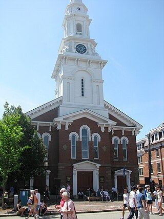
Street musicians perform across from North Church (July 2014)
USS Albacore Museum & Park – a museum featuring the USS Albacore, a U.S. Navy submarine used for testing, which was decommissioned in 1972 and moved to the park in 1985. The submarine is open for tours.
Buckminster House – built in 1725, formerly a funeral parlor.[26][27]
Cabot Lyford four public sculptures – including "The Whale" and "My Mother the Wind," a seven-ton blank granite statue which was installed on Portsmouth's waterfront in 1975.[28]
New Hampshire Theatre Project – founded in 1986, a non-profit theater organization producing contemporary and classical works, and offering educational programs.[30]
North Church – historic church, the steeple of which is visible from most of Portsmouth
The Player's Ring Theater – a black-box theater that produces original work from local playwrights.
Pontine Theatre – produces original theater works based on the history, culture and literature of New England at their 50-seat black box venue.[31]
Portsmouth African Burying Ground – a memorial park and the only archeologically verified 18th-century African burying ground in New England.
Portsmouth Athenæum – a private membership library, museum and art gallery open to the public at certain times.
Portsmouth Harbor Lighthouse – first established in 1771, the current structure was built in 1878 and is open for monthly tours from May through September.
Portsmouth Historical Society – founded in 1917, includes museum galleries, a gift shop, welcome center, walking tours, and operates the John Paul Jones House.[32]
Prescott Park Arts Festival – summer entertainments in Portsmouth's waterfront park since 1974.[33]
Rockingham Hotel and the Library Restaurant – historic former hotel and contemporary restaurant. Built in 1885, it is a prominent early example of Colonial Revival architecture.
Seacoast Repertory Theatre – founded in 1988, a professional theater troupe.[34]
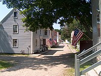
Strawbery Banke Museum – a neighborhood featuring several dozen restored historic homes in Colonial, Georgian and Federal styles of architecture. The site of one of Portsmouth's earliest settlements.
Whaling Wall – Painting of Isles of ShoalsHumpbacks created by Robert Wyland, situated on the back of Cabot House Furniture. It is in disrepair, and restoration has not been allowed by the owners of Cabot Furniture.[35]
Freedom Rugby Football Club is a men's rugby union team based in Portsmouth, founded in the summer of 2014. The club is an active member of USA Rugby and New England Rugby Football Union (NERFU).
Government
The city of Portsmouth operates under a council-manager system of government. Portsmouth elects a nine-member at-large City Council to serve as the city's primary legislative body.[36] The candidate who receives the most votes is designated the Mayor (currently Deaglan McEachern), while the candidate receiving the second-highest vote total is designated the Assistant Mayor (currently Joanna Kelley). While the mayor and council convene to establish municipal policy, the City Manager (currently Karen Conard) oversees the city's day-to-day operations.[37]
Portsmouth city vote by party in presidential elections[38]
In March 2014, Portsmouth became the first municipality in New Hampshire to implement protections for city employees from discrimination on the basis of gender identity, by a 9–0 vote of the city council.[43]
The Cooperative Alliance for Seacoast Transportation (COAST) operates a publicly funded bus network in the Seacoast region of New Hampshire and neighboring Maine including service in, to and from Portsmouth.[44] C&J is a private intercity bus carrier connecting Portsmouth with coastal New Hampshire and Boston, as well as direct service to New York City.[45]Wildcat Transit, operated by the University of New Hampshire, provides regular bus service to the UNH campus in Durham and intermediate stops. The service is free for students, faculty and staff and $1.50 for the general public.[46]Amtrak's Downeaster train service, is available in Dover and Durham, nearby to the northwest. Allegiant Air offers scheduled airline service from Portsmouth International Airport at Pease (PSM).[47]
Rockingham County is a county in the U.S. state of New Hampshire. As of the 2020 census, the population was 314,176, making it New Hampshire's second-most populous county. The county seat is Brentwood. Rockingham County is part of the Boston-Cambridge-Newton, MA-NH Metropolitan Statistical Area and the greater Boston-Worcester-Providence, MA-RI-NH-CT Combined Statistical Area. Per the 2020 census, it was New Hampshire's fastest growing county from 2010 to 2020.
Eliot is a town in York County, Maine, United States. Originally settled in 1623, it was formerly a part of Kittery, to its east. After Kittery, it is the next most southern town in the state of Maine, lying on the Piscataqua River across from Portsmouth and Newington, New Hampshire. The population was 6,717 at the 2020 census. It is part of the Portland–South Portland–Biddeford, Maine metropolitan statistical area.
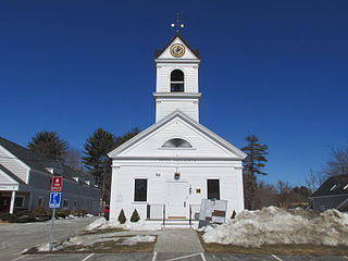
Fremont is a town in Rockingham County, New Hampshire, United States. The population was 4,739 at the 2020 census, up from 4,283 at the 2010 census. Fremont is crossed by the Rockingham Recreation Trail and NH Route 107.
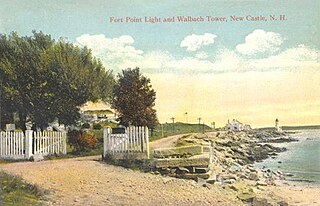
New Castle is a town in Rockingham County, New Hampshire, United States. The population was 1,000 at the 2020 census. It is the smallest and easternmost town in New Hampshire, and the only one located entirely on islands. It is home to Fort Constitution Historic Site, Fort Stark Historic Site, and the New Castle Common, a 31-acre (13 ha) recreation area on the Atlantic Ocean. New Castle is also home to a United States Coast Guard station, as well as the historic Wentworth by the Sea hotel.
Newington is a town in Rockingham County, New Hampshire, United States. The population was 811 at the 2020 census. It is bounded to the west by Great Bay, northwest by Little Bay and northeast by the Piscataqua River. It is home to Portsmouth International Airport at Pease and to the New Hampshire Air National Guard. The 110-acre (45 ha) Old Town Center Historic District is listed on the National Register of Historic Places.
North Hampton is a town in Rockingham County, New Hampshire, United States. The population was 4,538 at the 2020 census. While the majority of the town is inland, North Hampton includes a part of New Hampshire's limited Atlantic seacoast.
Rye is a town in Rockingham County, New Hampshire, United States. The population was 5,543 at the 2020 census. The town is home to several state parks along the Atlantic coastline.
Dover is a city in Strafford County, New Hampshire, United States. The population was 32,741 at the 2020 census, making it the most populous city in the New Hampshire Seacoast region and the 5th most populous city in New Hampshire. It is the county seat of Strafford County, and home to Wentworth-Douglass Hospital, the Woodman Institute Museum, and the Children's Museum of New Hampshire.
Exeter is a town in Rockingham County, New Hampshire, United States. Its population was 16,049 at the 2020 census, up from 14,306 at the 2010 census. Exeter was the county seat until 1997, when county offices were moved to neighboring Brentwood. Home to Phillips Exeter Academy, a private university-preparatory school, Exeter is situated where the Exeter River becomes the tidal Squamscott River.
Derry is a town in Rockingham County, New Hampshire, United States. The population was 34,317 at the 2020 census. Although it is a town and not a city, Derry is the most populous community in Rockingham County and the 4th most populous in the state. The town's nickname, "Spacetown", derives from the fact that Derry is the birthplace of Alan Shepard, the first astronaut from the United States in space. Derry was also for a time the home of the poet Robert Frost and his family.
The Piscataqua River is a 12-mile-long (19 km) tidal river forming the boundary of the U.S. states of New Hampshire and Maine from its origin at the confluence of the Salmon Falls River and Cochecho River to the Atlantic Ocean. The drainage basin of the river is approximately 1,495 square miles (3,870 km2), including the subwatersheds of the Great Works River and the five rivers flowing into Great Bay: the Bellamy, Oyster, Lamprey, Squamscott, and Winnicut.
The Seacoast Region is the southeast area of the U.S. state of New Hampshire that is centered around the city of Portsmouth. It includes the eastern portion of Rockingham County and the southern portion of Strafford County. At its narrowest definition, the region stretches 13 miles (21 km) along the Atlantic Ocean from New Hampshire's border with Salisbury, Massachusetts, to the Piscataqua River and New Hampshire's border with Kittery, Maine. The shoreline alternates between rocky and rough headlands and areas with sandy beaches. Some of the beaches are bordered by jetties or groins, particularly in the towns of Rye and Hampton. Most definitions of the Seacoast Region includes some inland towns as well, including the Great Bay area cities of Dover and Rochester, the college town of Durham, and areas as far west as Epping. Some definitions also include nearby portions of York County, Maine that are culturally aligned with the Portsmouth area rather than the Portland, Maine metropolitan area.
Interstate 95 (I-95) is an Interstate Highway on the east coast of the United States, connecting Florida to Maine. Within the state of New Hampshire, it serves the Seacoast Region and is a toll road named the Blue Star Turnpike or New Hampshire Turnpike. The 16.11-mile (25.93 km) turnpike is maintained by the New Hampshire Department of Transportation (NHDOT) Bureau of Turnpikes and has a single toll plaza near Hampton.
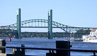
The World War I Memorial Bridge is a vertical-lift bridge that carries U.S. Route 1 across the Piscataqua River between Portsmouth, New Hampshire, and Badger's Island in Kittery, Maine, United States. The current bridge was opened in 2013, replacing a bridge of similar design that existed from 1923 to 2012. A large overhead plaque carried over from the original reads "Memorial to the Sailors and Soldiers of New Hampshire who gave their lives in the World War 1917–1919."
Strawbery Banke is an outdoor history museum located in the South End historic district of Portsmouth, New Hampshire. It is the oldest neighborhood in New Hampshire to be settled by Europeans, and the earliest neighborhood remaining in the present-day city of Portsmouth. It features more than 37 restored buildings built between the 17th and 19th centuries in the Colonial, Georgian, and Federal style architectures. The buildings once clustered around a waterway known as Puddle Dock, which was filled in around 1900. Today the former waterway appears as a large open space.
U.S. Route 1 (US 1) is a north–south U.S. Route is the U.S. state of New Hampshire through Hampton and Portsmouth. It lies between Interstate 95 (I-95) and New Hampshire Route 1A (NH 1A).
A gundalow is a type of flat-bottomed sailing barge once common in Maine and New Hampshire rivers, United States. It first appeared in the mid-1600s, reached maturity of design in the 1700 and 1800s, and lingered into the early 1900s before nearly vanishing as a commercial watercraft.
The North Church of Portsmouth, New Hampshire, United States, is a historic Congregational church located in Market Square. Sited directly across from the Portsmouth Athenæum, it features an Italianate edifice and a steeple visible from most of the city, the Piscataqua River, and communities on its western bank in Maine. Its spire has been referred to as Portsmouth's "landmark of record". The church is home to Portsmouth's United Church of Christ congregation.
Helen "Eileen" Foley was an American politician. Foley served as the Mayor of Portsmouth, New Hampshire, eight terms from 1968–1971, 1984–1985, and 1988–1997. She remains the longest-serving mayor in the city's history. She represented the 24th District in the New Hampshire Senate for seven terms, including one term as the Democratic Party Minority Leader.
The Portsmouth Downtown Historic District encompasses the historic urban core of Portsmouth, New Hampshire. With a history dating to the 17th century, Portsmouth was New Hampshire's principal seaport and the center of its economy for many decades, and the architecture of its urban center is reflective of nearly four centuries of history. The district is roughly L-shaped, radiating from the downtown Market Square area to South Street in the south and Madison and Columbia streets in the west, with more than 1,200 historically significant buildings. It was listed on the National Register of Historic Places in 2017. The district includes 35 previous listings on the National Register, and five National Historic Landmarks.
This page is based on this Wikipedia article Text is available under the CC BY-SA 4.0 license; additional terms may apply. Images, videos and audio are available under their respective licenses.