
Arunachal Pradesh is a state in Northeastern India. It was formed from the erstwhile North-East Frontier Agency (NEFA) region, and became a state on 20 February 1987. It borders the states of Assam and Nagaland to the south. It shares international borders with Bhutan in the west, Myanmar in the east, and a disputed border with China in the north at the McMahon Line. Itanagar is the state capital of Arunachal Pradesh. Arunachal Pradesh is the largest of the Seven Sister States of Northeast India by area. Arunachal Pradesh shares a 1,129 km border with China's Tibet Autonomous Region.

Dibang Valley (Pron:/dɪˈbæŋ/) is a district of Arunachal Pradesh named after the Dibang River or the Talon as the Mishmis call it. It is the least populated district in India and has an area of 9,129 square kilometres (3,525 sq mi).

Lohit is an administrative district in the state of Arunachal Pradesh in India. The district headquarters is located at Tezu. As of 2011 it is the third most populous district of Arunachal Pradesh, after Papum Pare and Changlang.
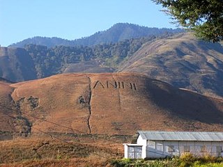
Anini is the headquarters of the Dibang Valley district in the state of Arunachal Pradesh in Northeast India. Anini was also the district headquarters of the undivided Dibang Valley district. Most of this location's population consists of the Idu Mishmi tribal people. Due to its remote location, Anini remains a small and underdeveloped town. However, it still has basic road and air links to the rest of India. The town is fully dependent on the nearest major settlement, Roing, which is in the Lower Dibang Valley District, for most commercial needs.

Pasighat is the headquarters of East Siang district in the Indian state of Arunachal Pradesh. Situated at the eastern foothills of the Himalayas at 155 meters (509 ft) above mean sea level, Pasighat is Arunachal's oldest town. The Government of India included Pasighat in the Smart Cities Mission development scheme in June 2017.
Tezu is a census town and the headquarters of Lohit district in the Indian state of Arunachal Pradesh. It is the fifth largest town in Arunachal Pradesh and one of its most developed.

Walong is an administrative town and the headquarters of eponymous circle in the Anjaw district in eastern-most part of Arunachal Pradesh state in India. It also has a small cantonment of the Indian Army. Walong is on banks of Lohit River, which enters India 35 km north of Walong at India-China LAC at Kaho pass.

Roing is the district headquarter of Lower Dibang Valley district in the Indian state of Arunachal Pradesh. It is the last major township at the north-eastern frontier of India.

Anjaw District (Pron:/ˈændʒɔ:/) is an administrative district in the state of Arunachal Pradesh in north-east India. It was created district in 2004, by splitting off from the Lohit district under the Arunachal Pradesh Re-organization of Districts Amendment Act. The district borders China on the north. Hawai, at an altitude of 1296 m above sea level, is the district headquarters, located on the banks of the Lohit River, a tributary of the Brahmaputra River. It is the easternmost district in India. The furthest villages towards the border with China are Dong, Walong, Kibithu and Kaho.
Hawai is the district headquarters of the newly created Anjaw District in the state of Arunachal Pradesh in north-east India.
Kibithu, also spelled Kibithoo, is a village in Arunachal Pradesh in Anjaw district. It is one of the easternmost permanently populated towns of India, located on the LAC at 28°16′49″N97°01′04″E. It is nearly 70 km north of district headquarter at Hawai, nearly 15 km south of India-China LAC (Kaho), and 40 km west of Diphu Pass near India-China-Myanmar tri-junction. The Lohit River enters India north of Kibithu at Kaho. Nearest air connectivity is 20 km in the south at Walong airstrip in Walong.

Kalikho Pul was an Indian politician and former Chief Minister of the north-eastern state of Arunachal Pradesh for a brief time in 2016. He was elected five times from the Hayuliang Vidhan Sabha constituency representing the Indian National Congress. With the support of a few elected members of Congress and the opposing Bharatiya Janata Party, he took Chief Ministership of Arunachal Pradesh. However, the Supreme Court of India ruled against this appointment on various grounds. On 9 August 2016, Pul allegedly committed suicide by hanging at his official residence in Itanagar; Pul's supporters protested in Itanagar demanding an investigation by the Central Bureau of Investigation (CBI).

Tuting is a town and headquarters of an eponymous circle in the Upper Siang district in Arunachal Pradesh, India. It is situated on the bank of Siang river (Brahmaputra) at a distance of 34 km (21 mi) south of Line of Actual Control and 170 km (110 mi) north of Yingkiong. Tuting is the center of an assembly constituency, and also home to an Indian Military headquarters. The border area reports frequent incursion attempts by the Chinese People's Liberation Army, including an attempt to construct a road in Indian territory.
Chaglagam is a village and the headquarters of an eponymous circle in the Anjaw district in the north-eastern state of Arunachal Pradesh, India. It is on the bank of the Delei River.
Vijaynagar is the most remote town and circle headquarters in the Changlang district, Arunachal Pradesh, India.

Mayodia Pass, 56 km from Roing in Dibang Valley district of Arunachal Pradesh state in India, is a popular local tourist attraction due to the November to March winter snow fall which is heaviest in January and February.
Kaho is a small village on the banks of Lohit River at an elevation of 1,240 metres (4,070 ft) on the India-China LAC in Anjaw district of Arunachal Pradesh state in India. It is 580 km east of Itanagar, nearly 70 km north of district headquarter at Hawai, nearly 8 km south of India-China LAC, 30 km west of Diphu Pass near India-China-Myanmar tri-junction, and 10 km north of Kibithu. Nearest air connectivity is 30 km in the south at Walong airstrip in Walong. The village has an Indian Army check-post. Kaho will be projected as the first village of the country by team Discover FarEast with the help of district administration.
Metengliang is a village and the headquarters of an eponymous circle in the Anjaw district in the north-eastern state of Arunachal Pradesh, India.
Goiliang is a village and the headquarters of an eponymous circle in the Anjaw district in the north-eastern state of Arunachal Pradesh, India.

