High Street Kensington tube station

Last updated

High Street Kensington Underground no-text.svg
High Street Kensington station October 2013.jpg
Entrance is through Kensington Arcade
Open street map central london.svg
Red pog.svg
High Street Kensington
Location of High Street Kensington in Central London
Location Kensington High Street
Local authority Royal Borough of Kensington and Chelsea
Managed by London Underground
Number of platforms4
Fare zone 1
London Underground annual entry and exit
2018Decrease2.svg 11.50 million [1]
2019Increase2.svg 11.69 million [2]
2020Decrease2.svg 3.57 million [3]
2021Increase2.svg 4.45 million [4]
2022Increase2.svg 8.54 million [5]
Key dates
1 October 1868Opened
25 November 1963Goods yard closed [6]
Other information
External links
Coordinates 51°30′03″N0°11′33″W / 51.5008°N 0.1925°W / 51.5008; -0.1925
Underground sign at Westminster.jpg London transportportal

High Street Kensington is a London Underground station on Kensington High Street, in Kensington. The station is on the Circle line between Gloucester Road and Notting Hill Gate, and the District line between Earl's Court and Notting Hill Gate and is in Travelcard Zone 1. Kensington Arcade forms the entrance to the station.

Contents

Station layout

The station itself has four platforms─two through platforms and two bay platforms. Platform 1 is used for anticlockwise Circle line and westbound District line trains towards Gloucester Road and Earl's Court respectively. Platform 2 is for clockwise Circle line and eastbound District line trains towards Edgware Road. Platforms 3 and 4 are used for terminating District line trains from Earl's Court. Platform 3 is usually used for the Olympia service, which runs weekends and for special events, and platform 4 is usually only used at the start and end of the day. There used to be a waiting room between Platform 2 and 3 for customer use, but this was turned into a staff room for drivers shortly before the Circle line extension to Hammersmith was implemented in December 2009.

On Platform 3, westbound, there is one of the few surviving K8 telephone kiosks. Now used for the TfL internal system, the kiosk is Grade II listed. [7]

Just south of the station is the junction where the Circle and District lines diverge.

Services

The typical off-peak service from this station is:

Weekends and Special Events only:

Connections

London Buses routes 9, 23, 27, 28, 49, 52, 70, 328, 452 and C1, night routes N9, N27, N28 and N31 and Green Line route 702 serve the station. [8] [9]

Brief history

The station platforms in 1892 High Street Kensington 1892.jpg
The station platforms in 1892

The station was originally built by the Metropolitan Railway after parliament passed the Metropolitan Railway's and Metropolitan District Railway's Bill in 1864. Work started in 1865, and in 1867 a barrel roof enclosed the station designed by the Metropolitan Railway's engineer Sir John Fowler. [10] The station, originally titled Kensington Station, had four lines, two for the Metropolitan Railway and two for the Metropolitan District Railway. The station was further redeveloped under the plans of the Metropolitan Railway's consultant architect George Campbell Sherrin between 1906 and 1907. [10] [11] [12] Sherrin's designs saw the barrel roof was taken off with the platforms covered by plain wooden shelters on iron columns. The North end of the platforms saw a new superstructure built over them, which contained a new octagonal booking hall, and an arcade that lead to the High Street. The space in the arcade was taken by neighbouring department stores Pontings and Derry & Toms. [10] [13] [14] [15] The octagonal booking hall was rebuilt by London Transport in 1937-38 to increase its capacity. [10] [14]

See also

Related Research Articles

<span class="mw-page-title-main">District line</span> London Underground line

The District line is a London Underground line running from Upminster in the east and Edgware Road in the west to Earl's Court in west London, where it splits into multiple branches. One branch runs to Wimbledon in south-west London and a short branch, with a limited service, only runs for one stop to Kensington (Olympia). The main route continues west from Earl's Court to Turnham Green after which it divides again into two western branches, to Richmond and Ealing Broadway.

<span class="mw-page-title-main">Baker Street tube station</span> London Underground station

Baker Street is a London Underground station at the junction of Baker Street and the Marylebone Road in the City of Westminster. It is one of the original stations of the Metropolitan Railway (MR), the world's first underground railway, opened on 10 January 1863.

<span class="mw-page-title-main">Bayswater tube station</span> London Underground station

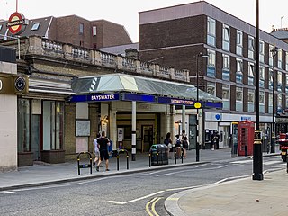
Bayswater is a London Underground station in the Bayswater area of the City of Westminster. The station is on the Circle and District lines, between Notting Hill Gate and Paddington stations and is in Travelcard Zone 1. It is less than 100 metres (330 ft) away from the Central line's Queensway station.

<span class="mw-page-title-main">South Kensington tube station</span> London Underground station

South Kensington is a London Underground station in the district of South Kensington, south west London. It is served by the District, Circle and Piccadilly lines. On the District and Circle lines it is between Gloucester Road and Sloane Square, and on the Piccadilly line between Gloucester Road and Knightsbridge. It is in Travelcard Zone 1. The main station entrance is located at the junction of Old Brompton Road (A3218), Thurloe Place, Harrington Road, Onslow Place and Pelham Street. Subsidiary entrances are located in Exhibition Road giving access by pedestrian tunnel to the Natural History, Science and Victoria and Albert Museums. Also close by are the Royal Albert Hall, Imperial College London, the Royal College of Music, the London branch of the Goethe-Institut and the Ismaili Centre.

<span class="mw-page-title-main">Westminster tube station</span> London Underground station

Westminster is a London Underground station in the City of Westminster. It is served by the Circle, District and Jubilee lines. On the Circle and District lines, the station is between St James's Park and Embankment, and on the Jubilee line it is between Green Park and Waterloo. It is in Travelcard Zone 1. The station is located at the corner of Bridge Street and Victoria Embankment and is close to the Houses of Parliament, Westminster Abbey, Parliament Square, Whitehall, Westminster Bridge, and the London Eye. Also close by are Downing Street, the Cenotaph, Westminster Millennium Pier, the Treasury, the Foreign and Commonwealth Office, and the Supreme Court.

<span class="mw-page-title-main">Moorgate station</span> London Underground and railway station

Moorgate is a central London railway terminus and connected London Underground station on Moorgate in the City of London. Main line railway services for Hertford, Welwyn Garden City and Stevenage are operated by Great Northern, while the Underground station is served by the Circle, Hammersmith & City, Metropolitan and Northern lines.

<span class="mw-page-title-main">Edgware Road tube station (Circle, District and Hammersmith & City lines)</span> London Underground station on the Circle, District and Hammersmith & City lines

Edgware Road is a London Underground station on the Circle, District and Hammersmith & City lines, located on the corner of Chapel Street and Cabbell Street, within Travelcard zone 1. A separate station of the same name but served by the Bakerloo line is located about 150 metres away on the opposite side of Marylebone Road.

<span class="mw-page-title-main">Gloucester Road tube station</span> London Underground station

Gloucester Road is a London Underground station in Kensington, west London. The station entrance is located close to the junction of Gloucester Road and Cromwell Road. Close by are the Cromwell Hospital and Baden-Powell House.

<span class="mw-page-title-main">Mansion House tube station</span> London Underground station

Mansion House is a London Underground station in the City of London which takes its name from Mansion House, the residence of the Lord Mayor of London. It opened in 1871 as the eastern terminus of the Metropolitan District Railway. Today, Mansion House is served by the Circle and District lines. It is between Blackfriars and Cannon Street stations and it is in fare zone 1. The station is located at the junction of Queen Victoria Street and Cannon Street.

<span class="mw-page-title-main">Sloane Square tube station</span> London Underground station

Sloane Square is a London Underground station in Chelsea, serving Sloane Square. It is served by the District and Circle lines, between South Kensington and Victoria stations and is in Travelcard Zone 1.

<span class="mw-page-title-main">St James's Park tube station</span> London Underground station

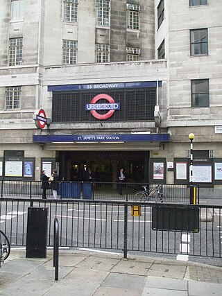
St James's Park is a London Underground station near St James's Park in the City of Westminster, central London. It is served by the District and Circle lines and is between Victoria and Westminster stations. It is in Travelcard Zone 1.

<span class="mw-page-title-main">Kentish Town station</span> London Underground and railway station

Kentish Town is an interchange station located in Kentish Town in the London Borough of Camden for London Underground and National Rail services.

<span class="mw-page-title-main">Chalfont & Latimer station</span> London Underground and railway station

Chalfont & Latimer is a London Underground and National Rail station in Travelcard Zone 8 on the Metropolitan line, in Buckinghamshire. It also serves the Chiltern Railways line to Aylesbury. Chalfont & Latimer station is located just before the junction for trains to Chesham. The station serves Chalfont St Giles, Chalfont St Peter, Little Chalfont and Latimer. It is located in Little Chalfont. It opened as "Chalfont Road" on 8 July 1889 but changed to the present name from 1 November 1915. The station is a good location to alight from to explore the Chess Valley.

<span class="mw-page-title-main">Kensington (Olympia) station</span> London Underground, London Overground and National rail station

Kensington (Olympia) is an interchange station located in Kensington, in West London for London Overground and National Rail services. Limited London Underground services also run here.

<span class="mw-page-title-main">Northwick Park tube station</span> London Underground station

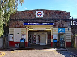
Northwick Park is a London Underground station in Kenton in the London Borough of Brent on the Metropolitan line. It lies between Harrow-on-the-Hill and Preston Road stations and is in Travelcard zone 4. The station takes its name from the nearby public park, Northwick Park.

<span class="mw-page-title-main">Burnt Oak tube station</span> London Underground station

Burnt Oak is a London Underground station in Burnt Oak, north London, on Watling Avenue, off the A5. The station is on the Edgware branch of the Northern line, between Edgware and Colindale stations, and is in Travelcard Zone 4.

<span class="mw-page-title-main">Latimer Road tube station</span> London Underground station

Latimer Road is a London Underground station in North Kensington, in the Royal Borough of Kensington and Chelsea. It is on the Circle and Hammersmith & City lines between Wood Lane and Ladbroke Grove stations and is in Travelcard Zone 2.

<span class="mw-page-title-main">Chorleywood station</span> London Underground and railway station

Chorleywood is a London Underground and National Rail station in Travelcard Zone 7 on the Metropolitan line. The village of Chorleywood is in the Three Rivers district of Hertfordshire about 20 miles (32 km) from London. Chorleywood station is also served by Chiltern Railways, which runs trains from London Marylebone station through to Aylesbury.

<span class="mw-page-title-main">West Brompton station</span> London Underground, London Overground and National Rail station

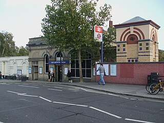
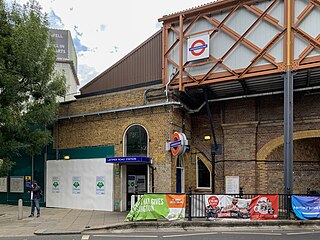
West Brompton is a station located on Old Brompton Road (A3218) in West Brompton, West London for London Underground, London Overground and National Rail services. It is immediately south of the demolished Earls Court Exhibition Centre and west of Brompton Cemetery in the Royal Borough of Kensington and Chelsea.

<span class="mw-page-title-main">Paddington tube station (Bakerloo, Circle and District lines)</span> London Underground station

Paddington is a London Underground station served by the Bakerloo, Circle and District lines. It is located on Praed Street to the south of Paddington mainline station and has entrances from Praed Street and from within the mainline station. On the Bakerloo line the station is between Warwick Avenue and Edgware Road and on the Circle and District lines it is between Bayswater and Edgware Road. It is in London Fare Zone 1.

References

  1. "Station Usage Data" (CSV). Usage Statistics for London Stations, 2018. Transport for London. 23 September 2020. Archived from the original on 14 January 2023. Retrieved 11 October 2023.
  2. "Station Usage Data" (XLSX). Usage Statistics for London Stations, 2019. Transport for London. 23 September 2020. Archived from the original on 9 November 2020. Retrieved 9 November 2020.
  3. "Station Usage Data" (XLSX). Usage Statistics for London Stations, 2020. Transport for London. 16 April 2021. Retrieved 1 January 2022.
  4. "Station Usage Data" (XLSX). Usage Statistics for London Stations, 2021. Transport for London. 12 July 2022. Retrieved 7 September 2022.
  5. "Station Usage Data" (XLSX). Usage Statistics for London Stations, 2022. Transport for London. 4 October 2023. Retrieved 10 October 2023.
  6. Hardy, Brian, ed. (March 2011). "How it used to be – freight on The Underground 50 years ago". Underground News (591). London Underground Railway Society: 175–183. ISSN   0306-8617.
  7. Historic England (31 May 2023). "K8 kiosk at Chalfont and Latimer Station (Grade II) (1484974)". National Heritage List for England .
  8. "Buses from Kensington High Street" (PDF). TfL. 12 November 2022. Retrieved 24 December 2022.
  9. "Night buses from Kensington High Street" (PDF). TfL. 10 July 2021. Retrieved 24 December 2022.
  10. 1 2 3 4 London County Council, London (1986). Survey of London: Volume 42, Kensington Square To Earl's Court. pp. 77–98.
  11. Jackson, Alan Arthur (1986). London's Metropolitan Railway. p. 197. ISBN   0715388398.
  12. "B/W print; Exterior view of High Street Kensington Underground station by H K Nolan, 4 Feb 1959". London Transport Museum. Retrieved 7 June 2024.
  13. 1 2 "High Street Kensington". Heritage Gateway. Retrieved 7 June 2024.
  14. "Company: Ponting Brothers". House of Fraser Archive at University of Glasgow. Retrieved 7 June 2024.
Preceding station Underground no-text.svg London Underground Following station
Gloucester Road
towards Hammersmith via  Tower Hill
Circle line
Notting Hill Gate
towards Edgware Road
Earl's Court
towards Wimbledon
District line
Edgware Road branch
Earl's Court District line Terminus