Sloane Square tube station

Last updated

Sloane Square Underground no-text.svg
Sloane Square stn entrance.JPG
Entrance on Sloane Square
Open street map central london.svg
Red pog.svg
Sloane Square
Location of Sloane Square in Central London
Location Chelsea
Local authority Royal Borough of Kensington and Chelsea
Managed by London Underground
Number of platforms2
Fare zone 1
London Underground annual entry and exit
2018Decrease2.svg 15.62 million [1]
2019Increase2.svg 16.59 million [2]
2020Decrease2.svg 6.28 million [3]
2021Increase2.svg 7.38 million [4]
2022Increase2.svg 12.77 million [5]
Key dates
24 December 1868Opened (DR)
1 February 1872Started "Outer Circle" (LNWR)
1 August 1872Started "Middle Circle" (GWR)
30 June 1900Ended "Middle Circle"
31 December 1908Ended "Outer Circle"
Other information
External links
Coordinates 51°29′33″N0°09′24″W / 51.4925°N 0.1566°W / 51.4925; -0.1566
Underground sign at Westminster.jpg  London transportportal

Sloane Square is a London Underground station in Chelsea, serving Sloane Square. It is served by the District and Circle lines, between South Kensington and Victoria stations and is in Travelcard Zone 1. [6]

Contents

The entrance to the station is on the east side of Sloane Square (A3217). It is adjacent to the Royal Court Theatre and is the nearest station for King's Road shopping, the Peter Jones department store and the Cadogan Hall. [7]

History

Plan of Sloane Square station, Sloane Square and surrounding streets, as they were in 1888. DISTRICT(1888) p125 - Sloane Square (map).jpg
Plan of Sloane Square station, Sloane Square and surrounding streets, as they were in 1888.

The station was opened on 24 December 1868 by the District Railway (DR, now the District line) when the company opened the first section of its line between South Kensington and Westminster stations. [8]

The River Westbourne, one of London's many subterranean rivers, flows above the station in a large iron conduit. Above ground platforms at Sloane Square tube station September 2022.jpg
The River Westbourne, one of London's many subterranean rivers, flows above the station in a large iron conduit.

The construction of the station was complicated by the crossing of the site by the River Westbourne which ran through Hyde Park as the Serpentine Lake and was originally crossed by the Knight's Bridge at Knightsbridge. The river was carried above the platform in a large iron pipe suspended from girders. This pipe remains in place today. [9]

The DR connected to the Metropolitan Railway (MR, later the Metropolitan line) at South Kensington and, although the two companies were rivals, each company operated its trains over the other's tracks in a joint service known as the "Inner Circle".

On 1 February 1872, the DR opened a northbound branch from its station at Earl's Court to connect to the West London Extension Joint Railway (WLEJR, now the West London line) to which it connected at Addison Road (now Kensington (Olympia)). From that date the "Outer Circle" service began running over the DR's tracks. [10] The service was run by the London and North Western Railway (LNWR) from Broad Street (now demolished) in the City of London via the North London line to Willesden Junction, then the West London Line to Addison Road. From Addison Road it ran over DR tracks to Mansion House. [10]

From 1 August 1872, the "Middle Circle" service also began operations through Sloane Square running from Moorgate along the MR's tracks on the north side of the Inner Circle to Paddington then over the Hammersmith & City Railway (H&CR) track to Latimer Road then, via a now demolished link, to the West London line to Addison Road and the DR to Mansion House. The service was operated by the Great Western Railway. [11]

On 30 June 1900, the Middle Circle service was withdrawn between Earl's Court and Mansion House. [12] On 31 December 1908, the Outer Circle service was also withdrawn. [12]

In the late 1930s, the station building was rebuilt in the modern style. Escalators were installed between the ticket hall and the platforms in early 1940, making the station the first on the sub-surface network to have escalators. [13] The new station building did not last long as it was mostly destroyed during World War II. A German bomb that fell in November 1940 killed 37 and injured 79 passengers on a train [14] [ self-published source ] in the station and destroyed the ticket hall, escalators and the glazed roof over the tracks.

In 1949, the Metropolitan line operated Inner Circle route was given its own identity on the tube map as the Circle line. By 1951 the station had been rebuilt again in a similar style to the 1930s building. The arched glass roof was not replaced and the current station does not have the light open atmosphere of the original. The office building above the station entrance is a later addition.

The Hole in the Wall pub on the eastbound platform existed from 1868 to 1985. [15]

Incidents and accidents

On 5 April 1960, Peter Llewelyn Davies, one of the Llewelyn Davies boys who were the inspiration for the boy characters of J. M. Barrie's Peter Pan, or The Boy Who Wouldn't Grow Up , and who resented the public association with the character named after him, committed suicide by throwing himself under a train as it was pulling into the station. [16]

On 26 December 1973, a terrorist bomb exploded in the telephone kiosk in the booking office. No one was injured. [17] [ self-published source ]

Former Chelsea-Hackney line proposal

Sloane Square was considered as a potential station on the long-proposed Chelsea-Hackney line which has been absorbed into plans for Crossrail 2. The station is no longer on the planned route. [18]

Connections

London Buses routes 11, 19, 22, 137, 170, 211, 319, 360, 452, C1 and night routes N11, N19, N22 and N137 serve the station. [19] [20]

Sloane Square is one of two tube stations (the other being South Kensington) mentioned in the song "When you're lying awake" from the operetta Iolanthe by Gilbert and Sullivan. [21]

Related Research Articles

<span class="mw-page-title-main">Tottenham Court Road station</span> National rail and London Underground station

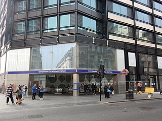
Tottenham Court Road is a London Underground and Elizabeth line station in St Giles in the West End of London. The London Underground station is served by the Central and Northern lines. On the Central line it is between Oxford Circus and Holborn stations, and on the Charing Cross branch of the Northern line it is between Goodge Street and Leicester Square stations. The station is located at St Giles Circus, the junction of Tottenham Court Road, Oxford Street, New Oxford Street and Charing Cross Road and is in Travelcard Zone 1, with a second entrance at Dean Street.

<span class="mw-page-title-main">Notting Hill Gate tube station</span> London Underground station

Notting Hill Gate is a London Underground station near Notting Hill, London, located on the street called Notting Hill Gate. On the Central line, it is between Holland Park to the west and Queensway to the east. On the District line and Circle line, it is between High Street Kensington and Bayswater stations. It is on the boundary of Travelcard Zone 1 and Zone 2.

<span class="mw-page-title-main">Embankment tube station</span> London Underground station

Embankment is a London Underground station in the City of Westminster, known by various names during its history. It is served by the Bakerloo, Circle, District and Northern lines. On the Bakerloo line and the Charing Cross branch of the Northern line, the station is between Charing Cross and Waterloo stations; on the Circle and District lines, it is between Westminster and Temple and is in Travelcard Zone 1. The station has two entrances, one on Victoria Embankment and the other on Villiers Street. The station is adjacent to Victoria Embankment Gardens and is close to Charing Cross station, Embankment Pier, Hungerford Bridge, Cleopatra's Needle, the Royal Air Force Memorial, the Savoy Chapel and Savoy Hotel and the Playhouse and New Players Theatres.

<span class="mw-page-title-main">King's Cross St Pancras tube station</span> London Underground station

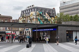
King's Cross St Pancras is a London Underground station on Euston Road in the Borough of Camden, Central London. It serves King's Cross and St Pancras main line stations in fare zone 1, and is an interchange between six Underground lines. The station was one of the first to open on the network. As of 2022, it is the most used station on the network for passenger entrances and exits combined.

<span class="mw-page-title-main">Baker Street tube station</span> London Underground station

Baker Street is a London Underground station at the junction of Baker Street and the Marylebone Road in the City of Westminster. It is one of the original stations of the Metropolitan Railway (MR), the world's first underground railway, opened on 10 January 1863.

<span class="mw-page-title-main">Bayswater tube station</span> London Underground station

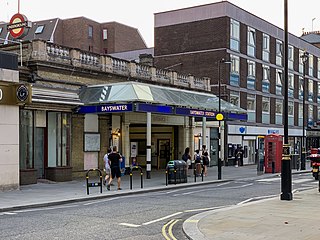
Bayswater is a London Underground station in the Bayswater area of the City of Westminster. The station is on the Circle and District lines, between Notting Hill Gate and Paddington stations and is in Travelcard Zone 1. It is less than 100 metres (330 ft) away from the Central line's Queensway station.

<span class="mw-page-title-main">South Kensington tube station</span> London Underground station

South Kensington is a London Underground station in the district of South Kensington, south west London. It is served by the District, Circle and Piccadilly lines. On the District and Circle lines it is between Gloucester Road and Sloane Square, and on the Piccadilly line between Gloucester Road and Knightsbridge. It is in Travelcard Zone 1. The main station entrance is located at the junction of Old Brompton Road (A3218), Thurloe Place, Harrington Road, Onslow Place and Pelham Street. Subsidiary entrances are located in Exhibition Road giving access by pedestrian tunnel to the Natural History, Science and Victoria and Albert Museums. Also close by are the Royal Albert Hall, Imperial College London, the Royal College of Music, the London branch of the Goethe-Institut and the Ismaili Centre.

<span class="mw-page-title-main">Westminster tube station</span> London Underground station

Westminster is a London Underground station in the City of Westminster. It is served by the Circle, District and Jubilee lines. On the Circle and District lines, the station is between St James's Park and Embankment, and on the Jubilee line it is between Green Park and Waterloo. It is in Travelcard Zone 1. The station is located at the corner of Bridge Street and Victoria Embankment and is close to the Houses of Parliament, Westminster Abbey, Parliament Square, Whitehall, Westminster Bridge, and the London Eye. Also close by are Downing Street, the Cenotaph, Westminster Millennium Pier, the Treasury, the Foreign and Commonwealth Office, and the Supreme Court.

<span class="mw-page-title-main">Earl's Court tube station</span> London Underground station

Earl's Court tube station is a Grade II listed London Underground station in Earl's Court, London, on the District and Piccadilly lines. It is an important interchange for both lines and is situated in both Travelcard Zone 1 and Zone 2. The station has an eastern entrance on Earl's Court Road and a western entrance on Warwick Road. Another former entrance allowed passengers to enter the station from the other side of Warwick Road, via a ticket hall and subway leading to a concourse beneath the District line platforms. Earl's Court is a step-free tube station; the Earls Court Road entrance provides lift access between street and platform levels.

<span class="mw-page-title-main">Gloucester Road tube station</span> London Underground station

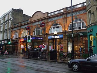
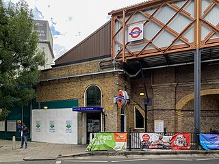
Gloucester Road is a London Underground station in Kensington, west London. The station entrance is located close to the junction of Gloucester Road and Cromwell Road. Close by are the Cromwell Hospital and Baden-Powell House.

<span class="mw-page-title-main">Mansion House tube station</span> London Underground station

Mansion House is a London Underground station in the City of London which takes its name from Mansion House, the residence of the Lord Mayor of London. It opened in 1871 as the eastern terminus of the Metropolitan District Railway. Today, Mansion House is served by the Circle and District lines. It is between Blackfriars and Cannon Street stations and it is in fare zone 1. The station is located at the junction of Queen Victoria Street and Cannon Street.

<span class="mw-page-title-main">Temple tube station</span> London Underground station

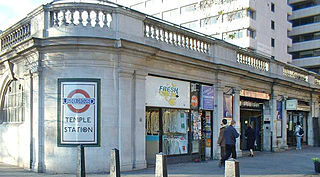
Temple is a London Underground station located at Victoria Embankment in the City of Westminster, close to its boundary with the City of London. It is on the Circle and District lines between Embankment and Blackfriars, and is in fare zone 1.

<span class="mw-page-title-main">Barbican tube station</span> London Underground station

Barbican is a London Underground station situated near the Barbican Estate, on the edge of the ward of Farringdon Within, in the City of London in Central London. It has been known by various names since its opening in 1865, mostly in reference to the neighbouring ward of Aldersgate.

<span class="mw-page-title-main">St James's Park tube station</span> London Underground station

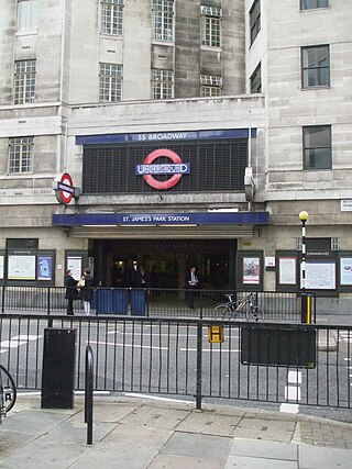
St James's Park is a London Underground station near St James's Park in the City of Westminster, central London. It is served by the District and Circle lines and is between Victoria and Westminster stations. It is in Travelcard Zone 1.

<span class="mw-page-title-main">Kensington (Olympia) station</span> London Underground, London Overground and National rail station

Kensington (Olympia) is an interchange station located in Kensington, in West London for London Overground and National Rail services. Limited London Underground services also run here.

<span class="mw-page-title-main">Latimer Road tube station</span> London Underground station

Latimer Road is a London Underground station in North Kensington, in the Royal Borough of Kensington and Chelsea. It is on the Circle and Hammersmith & City lines between Wood Lane and Ladbroke Grove stations and is in Travelcard Zone 2.

<span class="mw-page-title-main">Turnham Green tube station</span> London Underground station

Turnham Green is a London Underground station in Chiswick of the London Borough of Hounslow, west London. The station is served by the District and Piccadilly lines although currently Piccadilly line trains normally stop at the station only at the beginning and end of the day, running through non-stop at other times. To the east, District line trains stop at Stamford Brook and Piccadilly line trains stop at Hammersmith. To the west, District line trains run to either Chiswick Park or Gunnersbury and Piccadilly line trains stop at Acton Town. The station is in both Travelcard Zone 2 and Zone 3.

<span class="mw-page-title-main">Westbourne Park tube station</span> London Underground station

Westbourne Park is a London Underground station in the Notting Hill area of the Royal Borough of Kensington and Chelsea. It is on the Circle and Hammersmith and City lines, between Ladbroke Grove and Royal Oak stations, and is in Travelcard Zone 2.

<span class="mw-page-title-main">Stamford Brook tube station</span> London Underground station

Stamford Brook is a London Underground station on the eastern edge of Chiswick in west London. The station is served by the District line and is between Ravenscourt Park and Turnham Green stations. The main entrance is located on Goldhawk Road (A402) with a secondary entrance on Prebend Gardens. It is in Travelcard Zone 2.

<span class="mw-page-title-main">Paddington tube station (Bakerloo, Circle and District lines)</span> London Underground station

Paddington is a London Underground station served by the Bakerloo, Circle and District lines. It is located on Praed Street to the south of Paddington mainline station and has entrances from Praed Street and from within the mainline station. On the Bakerloo line the station is between Warwick Avenue and Edgware Road and on the Circle and District lines it is between Bayswater and Edgware Road. It is in London Fare Zone 1.

References

  1. "Station Usage Data" (CSV). Usage Statistics for London Stations, 2018. Transport for London. 23 September 2020. Archived from the original on 14 January 2023. Retrieved 11 October 2023.
  2. "Station Usage Data" (XLSX). Usage Statistics for London Stations, 2019. Transport for London. 23 September 2020. Archived from the original on 9 November 2020. Retrieved 9 November 2020.
  3. "Station Usage Data" (XLSX). Usage Statistics for London Stations, 2020. Transport for London. 16 April 2021. Retrieved 1 January 2022.
  4. "Station Usage Data" (XLSX). Usage Statistics for London Stations, 2021. Transport for London. 12 July 2022. Retrieved 7 September 2022.
  5. "Station Usage Data" (XLSX). Usage Statistics for London Stations, 2022. Transport for London. 4 October 2023. Retrieved 10 October 2023.
  6. Standard Tube Map (PDF) (Map). Not to scale. Transport for London. November 2022. Archived (PDF) from the original on 7 November 2022. Retrieved 12 November 2022.
  7. "Sloane Square Tube Station". Google Maps.
  8. Rose 1999.
  9. Jones, Ian (28 November 2012). "69. The river over Sloane Square". 150 Great Things About the Underground. Retrieved 1 December 2012.
  10. 1 2 Horne 2006, p. 15.
  11. Bruce 1983, p. 11.
  12. 1 2 Lee 1956, p. 29.
  13. Middleton, Peter (producer & writer) (1989). Metropolitan and District 1989 Driver's Eye View (documentary). Video125.
  14. Cooper, Nick. "Sloane Square 12/11/40". The Underground at War.
  15. "A History of Pubs on the London Underground". IanVisits. 25 December 2014. Retrieved 25 September 2017.
  16. Birkin, Andrew (1979). J. M. Barrie and the Lost Boys. Yale University Press.
  17. Cooper, Nick. "Terrorist Attacks on the London Underground". The Underground at War. Archived from the original on 13 October 2006.
  18. "Citizen Space – Crossrail 2 – October 2015". Archived from the original on 1 August 2017. Retrieved 22 November 2015.
  19. "Buses from Sloane Square" (PDF). TfL. 12 November 2022. Retrieved 24 December 2022.
  20. "Night buses from Sloane Square" (PDF). TfL. June 2022. Retrieved 24 December 2022.
  21. "When You're Lying Awake (lyrics)". Boise State University. Archived from the original on 7 October 2012. Retrieved 4 February 2016.

Bibliography

Preceding station Underground no-text.svg London Underground Following station
South Kensington
towards Edgware Road
Circle line
Victoria
towards Hammersmith via  Tower Hill
South Kensington District line
Victoria
towards Upminster