East Putney tube station

Last updated

East Putney Underground no-text.svg
East Putney stn District look north.JPG
Greater London UK location map 2.svg
Red pog.svg
East Putney
Location of East Putney in Greater London
Location Putney
Local authority London Borough of Wandsworth
Managed by London Underground
Number of platforms2
Fare zone 2 and 3
OSI Putney National Rail logo.svg [1]
London Underground annual entry and exit
2018Decrease2.svg 5.74 million [2]
2019Increase2.svg 6.45 million [3]
2020Decrease2.svg 3.06 million [4]
2021Decrease2.svg 3.01 million [5]
2022Increase2.svg 5.02 million [6]
Key dates
3 June 1889Opened (DR)
1 July 1889Started (LSWR)
4 May 1941Ended (SR)
Other information
External links
Coordinates 51°27′31″N0°12′41″W / 51.4587°N 0.2113°W / 51.4587; -0.2113
Underground sign at Westminster.jpg London transportportal

East Putney is a London Underground station in Putney in the London Borough of Wandsworth. It is on the Wimbledon branch of the District line, between Putney Bridge and Southfields, and is on the boundary between Travelcard Zones 2 and 3. The entrance to the station is on Upper Richmond Road (A205).

Contents

History

The station was opened by the District Railway (DR, now the District line) on 3 June 1889 as part of an extension from Putney Bridge station to Wimbledon. The extension was built by the London and South Western Railway (LSWR), which from 1 July 1889 ran its own trains over the line via connecting tracks from its Waterloo to Reading line at Point Pleasant Junction, just west of Wandsworth station (now Wandsworth Town), to East Putney.

The section of the District line from Putney Bridge to Wimbledon was the last part of the line to be converted from steam operation to electric. Electric trains began running on 27 August 1905.

Regular passenger services between Waterloo and Wimbledon through East Putney were ended by the Southern Railway (successor to the LSWR) on 4 May 1941, although the line remained in British Rail ownership until 1 April 1994 when it was sold to London Underground for the nominal sum of £1. Until the sale, the station was branded as a British Rail station. The route from Wandsworth Town to Wimbledon, including the connection between Point Pleasant Junction and East Putney (largely reduced to single track in 1990 [7] ), is still used by South Western Railway for empty stock movements and occasional service train diversions, as well as three daily SWR services which run to and from Waterloo via the route in the early hours of the morning (to maintain train crews' knowledge of the route) without stopping at East Putney.[ citation needed ] There are very infrequent movements of Network Rail engineering trains and light engine movements through the station as well.

Station layout

A 1914 Railway Clearing House Junction Diagram showing (left) the lines around East Putney station. Putney Bridge & Fulham, Evesham, Romford RJD 133.jpg
A 1914 Railway Clearing House Junction Diagram showing (left) the lines around East Putney station.

The junction between the District line and the connection to the Waterloo–Reading line is immediately to the south of the station, with the District line tracks on the western side of the station and the connection's tracks on the eastern side. The station is thus laid out as follows, from west to east: a side platform for northbound District line trains, a Y-shaped central island platform for southbound District line trains and eastbound main line trains, and a side platform for westbound main line trains. The street-level station entrance and buildings lie between the two arms of the island platform.

The side platform for westbound main line trains has been out of use since regular services between Waterloo and Wimbledon through the station were ended in 1941, and is overgrown, while a barrier seals off the right arm of the island platform, previously used by eastbound main line trains. The rest of the eastern side of the island platform remains in working order, and although not served by regular trains is very occasionally used for terminating services from Wimbledon in connection with engineering works.

The station has four staircases, two up to the island platform and one up to each side platform, although the one up to the disused side platform for westbound main line trains is not accessible to the public.

The connection to the Waterloo–Reading line was originally double track throughout, with the eastbound track diverging from the westbound track north-east of East Putney to cross over the Waterloo–Reading line on a viaduct, then running parallel to the line before joining it at Point Pleasant Junction. In 1990, this track was lifted between the divergence point and Point Pleasant Junction, and the decking over the Waterloo–Reading line was removed, although the central piers and abutments of the viaduct remain intact. The westbound track is now bi-directional between Point Pleasant Junction and the former divergence point. South Western Railway continues to use the connection for empty stock movements and occasional train service diversions.

Services

The typical offpeak service on a Monday to Friday at this station in trains per hour (tph) is as follows: [8] [9]

Connections

London Buses routes 37 and 337 serve the station.

Past plans

East Putney was a proposed stop on the Chelsea-Hackney Line (now Crossrail 2). It was envisaged that the station's District line service would have been replaced by the new line.

Related Research Articles

<span class="mw-page-title-main">South Kensington tube station</span> London Underground station

South Kensington is a London Underground station in the district of South Kensington, south west London. It is served by the District, Circle and Piccadilly lines. On the District and Circle lines it is between Gloucester Road and Sloane Square, and on the Piccadilly line between Gloucester Road and Knightsbridge. It is in Travelcard Zone 1. The main station entrance is located at the junction of Old Brompton Road (A3218), Thurloe Place, Harrington Road, Onslow Place and Pelham Street. Subsidiary entrances are located in Exhibition Road giving access by pedestrian tunnel to the Natural History, Science and Victoria and Albert Museums. Also close by are the Royal Albert Hall, Imperial College London, the Royal College of Music, the London branch of the Goethe-Institut and the Ismaili Centre.

<span class="mw-page-title-main">Richmond station (London)</span> London Underground, London Overground and National Rail station

Richmond, also known as Richmond (London), is a National Rail station in Richmond, Greater London on the Waterloo to Reading and North London Lines. South Western Railway services on the Waterloo to Reading Line are routed through Richmond, which is between North Sheen and St Margarets stations, 9 miles 57 chains (15.6 km) down the line from London Waterloo. For London Overground and London Underground services, the next station is Kew Gardens.

<span class="mw-page-title-main">Edgware Road tube station (Circle, District and Hammersmith & City lines)</span> London Underground station on the Circle, District and Hammersmith & City lines

Edgware Road is a London Underground station on the Circle, District and Hammersmith & City lines, located on the corner of Chapel Street and Cabbell Street, within Travelcard zone 1. A separate station of the same name but served by the Bakerloo line is located about 150 metres away on the opposite side of Marylebone Road.

<span class="mw-page-title-main">Rayners Lane tube station</span> London Underground station

Rayners Lane is a London Underground station in the district of Rayners Lane in north west London, amid a 1930s development originally named Harrow Garden Village. The station is on the Uxbridge branch of both the Metropolitan line, between Eastcote and West Harrow stations, and the Piccadilly line, between Eastcote and South Harrow stations. The station is located to the west of the junction of Rayners Lane, Alexandra Avenue and Imperial Drive (A4090). It is in Travelcard Zone 5. Just east of the station, the Piccadilly and Metropolitan lines tracks join for services to Uxbridge and separate for those to Central London.

<span class="mw-page-title-main">Barons Court tube station</span> London Underground station

Barons Court is a London Underground station in West Kensington in the London Borough of Hammersmith and Fulham, Greater London. This station serves the District line and the Piccadilly line. Barons Court is between West Kensington and Hammersmith on the District line, and between Earl's Court and Hammersmith on the Piccadilly line and is in Travelcard Zone 2. East of the station, the Piccadilly line descends into tunnel towards Earl's Court and the District line continues in a cutting to West Kensington. The station is the last open air stop for eastbound trains on the Piccadilly line until Arnos Grove and has cross-platform interchange with the District line.

<span class="mw-page-title-main">Wimbledon station</span> National rail, London Underground and tram station

Wimbledon is an interchange station in the centre of Wimbledon in London for London Underground, London Trams and National Rail services, and is the only station in London that provides an interchange between the London Underground and Tramlink.

<span class="mw-page-title-main">Bromley-by-Bow tube station</span> London Underground station

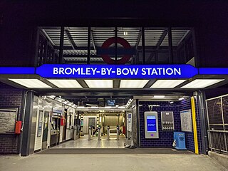
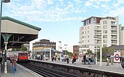
Bromley-by-Bow is a London Underground station located on the Blackwall Tunnel Northern Approach Road in the Bromley-by-Bow area of London, United Kingdom. The station is below the Blackwall Tunnel Northern Approach Road and lies between Bow Road and West Ham stations on the District and Hammersmith & City lines, and is in both Travelcard Zones 2 and 3.

<span class="mw-page-title-main">Ruislip tube station</span> London Underground station

Ruislip is a London Underground station in Ruislip in west London. The station is on the Uxbridge branch of both the Metropolitan line and Piccadilly line, between Ruislip Manor and Ickenham stations. The station is located on Station Approach. It is in Travelcard Zone 6. It is the oldest station on the Uxbridge branch and was originally the only intermediate station on the line between Uxbridge and Harrow-on-the-Hill.

<span class="mw-page-title-main">South Harrow tube station</span> London Underground station

South Harrow is a London Underground station on the Uxbridge branch of the Piccadilly line. It is between Rayners Lane and Sudbury Hill stations. It is located on Northolt Road (A312). The station is in Travelcard Zone 5. There are several bus stands outside the station as well as overnight train stabling sidings.

<span class="mw-page-title-main">Sudbury Hill tube station</span> London Underground station

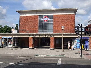
Sudbury Hill is a London Underground station on the Uxbridge branch of the Piccadilly line. The station is between Sudbury Town and South Harrow, and is in Travelcard Zone 4. It is located on Greenford Road (A4127) north of the junction with Whitton Avenue, on the border between the London Boroughs of Harrow and Ealing. The station is close to Sudbury Hill Harrow railway station.

<span class="mw-page-title-main">Alperton tube station</span> London Underground station

Alperton is a London Underground station in Alperton, north-west London. It is on the Uxbridge branch of the Piccadilly line between Sudbury Town and Park Royal stations, in Travelcard Zone 4. It is located on Ealing Road (A4089), a short distance from the junction with Bridgewater Road (A4005), and is close to the Paddington branch of the Grand Union Canal.

<span class="mw-page-title-main">Ealing Common tube station</span> London Underground station

Ealing Common is a London Underground station on the Uxbridge branch of the Piccadilly line and on the Ealing Broadway branch of the District line. Eastbound, the next station is Acton Town; westbound, the next station is North Ealing on the Piccadilly line and Ealing Broadway on the District line. Here, the District and Piccadilly lines share the same pair of tracks through the station – the only other example where a deep level line and a sub surface line share the same pair of tracks is further up the Uxbridge branch, where the Piccadilly line shares tracks with the Metropolitan line from Rayners Lane to Uxbridge. It is the only station west of Acton Town to be served by both the Piccadilly and District lines.

<span class="mw-page-title-main">Putney Bridge tube station</span> London Underground station

Putney Bridge is a London Underground station on the Wimbledon branch of the District line. It is between Parsons Green and East Putney stations and is in Zone 2. The station is located in the south of Fulham, adjacent to Fulham High Street and New Kings Road (A308) and is a short distance from the north end of Putney Bridge from which it takes its name.

<span class="mw-page-title-main">Putney railway station</span> National Rail station in London, England

Putney railway station serves Putney in the London Borough of Wandsworth, in southwest London straddling Travelcard zone 2 and zone 3. It is 5 miles 72 chains (9.5 km) down the line from London Waterloo.

<span class="mw-page-title-main">Hillingdon tube station</span> London Underground station

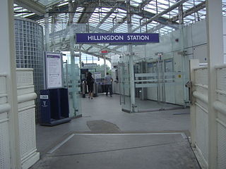
Hillingdon tube station is a London Underground station in North Hillingdon in the London Borough of Hillingdon, West London. Located between Uxbridge and Ickenham, it is in Travelcard Zone 6. It is the penultimate station on the Uxbridge branch of both the Metropolitan line and the Piccadilly line. Resited in 1992, it is also the most recently constructed station on the Metropolitan line.

<span class="mw-page-title-main">Sudbury Town tube station</span> London Underground station

Sudbury Town is a London Underground station on the Uxbridge branch of the Piccadilly line. The station is between Alperton and Sudbury Hill, and is in Travelcard Zone 4. It is located on the border between the London Boroughs of Brent and Ealing, with its main entrance on Station Approach in Sudbury. The forecourt of the station is known as Station Crescent. The station serves Sudbury, which forms the western part of Wembley.

<span class="mw-page-title-main">North Ealing tube station</span> London Underground station

North Ealing is a London Underground station on the Uxbridge branch of the Piccadilly line between Ealing Common and Park Royal. The station is located on Station Road, a short distance from the junction of Queen's Drive and Hanger Lane. It is in Travelcard Zone 3. West Acton station on the Central line is located about 550 metres to the east at the other end of Queen's Drive.

<span class="mw-page-title-main">Wimbledon Park tube station</span> London Underground station

Wimbledon Park is a London Underground station in Wimbledon. The station is on the District line and is between Southfields and Wimbledon stations. The station is located on Arthur Road close to the junction with Melrose Avenue close to the eastern side of Wimbledon Park. It is about 200 metres (660 ft) west of Durnsford Road (A218) and is in Travelcard Zone 3.

<span class="mw-page-title-main">Southfields tube station</span> London Underground station

Southfields is a London Underground station in Southfields in the London Borough of Wandsworth. The station is on the District line between East Putney and Wimbledon Park stations. The station is located on Wimbledon Park Road at the junction with Augustus Road and Replingham Road. It is in Travelcard Zone 3.

<span class="mw-page-title-main">Parsons Green tube station</span> London Underground station

Parsons Green is an above-ground London Underground station on the Wimbledon branch of the District line that opened in 1880. It is between Fulham Broadway and Putney Bridge stations and is in Zone 2. There are entrances on Parsons Green Lane and in Beaconsfield Walk. The station is a short distance north of the green itself. It was previously a train-operator depot, until functions were transferred to Earl's Court.

References

  1. "Out of Station Interchanges" (XLSX). Transport for London. 16 June 2020. Retrieved 5 November 2020.
  2. "Station Usage Data" (CSV). Usage Statistics for London Stations, 2018. Transport for London. 23 September 2020. Archived from the original on 14 January 2023. Retrieved 11 October 2023.
  3. "Station Usage Data" (XLSX). Usage Statistics for London Stations, 2019. Transport for London. 23 September 2020. Archived from the original on 9 November 2020. Retrieved 9 November 2020.
  4. "Station Usage Data" (XLSX). Usage Statistics for London Stations, 2020. Transport for London. 16 April 2021. Retrieved 1 January 2022.
  5. "Station Usage Data" (XLSX). Usage Statistics for London Stations, 2021. Transport for London. 12 July 2022. Retrieved 7 September 2022.
  6. "Station Usage Data" (XLSX). Usage Statistics for London Stations, 2022. Transport for London. 4 October 2023. Retrieved 10 October 2023.
  7. Brown, Joe (2009). London Railway Atlas (2nd ed.). Ian Allan Publishing. ISBN   978-0-7110-3397-9.
  8. "CULG - District Line". www.davros.org. Retrieved 23 December 2023.
  9. Matters, Transport for London | Every Journey. "District line timetable". Transport for London. Retrieved 23 December 2023.
Preceding station Underground no-text.svg London Underground Following station
Southfields
towards Wimbledon
District line
Wimbledon branch
Putney Bridge