Hutton's Unconformity

Last updated

Hutton's Unconformity is a name given to various notable geological sites in Scotland identified by the 18th-century Scottish geologist James Hutton as places where the junction between two types of rock formations can be seen. This geological phenomenon marks the location where rock formations created at different times and by different forces adjoin. For Hutton, such an unconformity provided evidence for his Plutonist theories of uniformitarianism and the age of Earth.

Contents

An unconformity is any break in the normal progression of sedimentary deposits, which are laid the newer on top of the older.

In his search, Hutton and colleagues examined rock outcrops and cliffs, both riverside and sea, and found several locations where two adjoining rock types had been laid bare, the most noted being at Siccar Point on the coast of Berwickshire.

Theory of rock formations

Hutton hit on a variety of ideas to explain the rock formations he saw, and, after a quarter century of work, [1] he read his paper, Theory of the Earth; or an Investigation of the Laws Observable in the Composition, Dissolution and Restoration of Land upon the Globe, to the Royal Society of Edinburgh on 7 March and 4 April 1785. [2]

Cover of the journal Transactions of the Royal Society of Edinburgh. This is the issue where James Hutton published his Theory of the Earth in 1788. Trans Royal Society of Edinburgh cover.jpg
Cover of the journal Transactions of the Royal Society of Edinburgh. This is the issue where James Hutton published his Theory of the Earth in 1788.

Later that year Hutton read an abstract of Concerning the System of the Earth, its Duration and Stability to a Society meeting, and had it printed and circulated privately. In it, he outlined his theory that the "solid parts of the present land appear in general, to have been composed of the productions of the sea, and of other materials similar to those now found upon the shores."

From this he deduced that the land was a composition which had been formed by the operation of second causes in an earlier world composed of sea and land, with tides, currents, and "such operations at the bottom of the sea as now take place" so that "while the present land was forming at the bottom of the ocean, the former land maintained plants and animals; at least the sea was then inhabited by animals, in a similar manner as it is at present", and that most, if not all, of the land had been produced by natural operations involving the consolidation of masses of loose materials collected at the bottom of the sea, followed by the elevation of the consolidated masses to their present position. [3]

Hutton's search for unconformities

Early geologists had interpreted angular unconformities in terms of Neptunism (holding that rocks had formed from the crystallisation of minerals from ocean waters after the Great Flood) but Hutton wanted to examine such formations himself in support for his theory of Plutonism, in which rocks are formed from volcanic action.

Hutton's Glen Tilt exposure at the collapsed Dail-an-eas Bridge upstream from Forest Lodge, drawn by John Clerk of Eldin in 1785; N 56.85109, W 3.74187 Hutton's Glen Tilt exposure at Dail-an-eas Bridge.jpg
Hutton's Glen Tilt exposure at the collapsed Dail-an-eas Bridge upstream from Forest Lodge, drawn by John Clerk of Eldin in 1785; N 56.85109, W 3.74187

In 1785 on Hutton's first field excursion, he was invited by the Duke of Atholl to search for exposures in a remarkably straight, deeply incised valley in the Scottish Highlands known as the Glen Tilt, near the town of Blair Atholl. Upstream of one of the Duke's hunting lodges, known as Forest Lodge, Hutton and his friend, John Clerk of Eldin, found exposures at the Dail-an-eas Bridge that demonstrated red igneous granite veins were injected into older grey schists formations. This discovery proved that Werner's Neptunism theory was in error. Werner argued that sedimentary rocks, including what are now known as metamorphic rocks such as schists, were formed after granites. John Clerk drew these exposures with great accuracy and these drawing provide important visual evidence of Hutton's discoveries. [4]

Hutton Unconformity at Inchbonny, Jedburgh. A photograph shows the current scene (2003), below Clerk of Eldin's illustration of 1787; N 55.4721, W 2.5545 Hutton Unconformity , Jedburgh.jpg
Hutton Unconformity at Inchbonny, Jedburgh. A photograph shows the current scene (2003), below Clerk of Eldin's illustration of 1787; N 55.4721, W 2.5545

On a trip to the Isle of Arran in 1787 he found his first example of an unconformity to the north of Newton Point near Lochranza, but the limited view did not give the information he needed. [5] [6] It occurs where vertically orientated Precambrian Dalradian schists are overlain by more recent cornstones in the Kinnesswood Formation of the Inverclyde Group (Lower Carboniferous), with an obvious difference in dip between the two rock layers, [7] [8] but he incorrectly thought that the strata were conformable at a depth below the exposed outcrop. [9] In 2017, the Arran Geopark Project erected a marker stone to indicate the significance of Hutton's discovery and its location (map reference: NR936521) [10]

Later in 1787 Hutton noted what is now known as the Hutton Unconformity at Inchbonny, Jedburgh, in layers of sedimentary rock visible on the banks of the Jed Water. [11] He later wrote of how he "rejoiced at my good fortune in stumbling upon an object so interesting in the natural history of the earth, and which I had been long looking for in vain". That year he found the same sequence in Teviotdale. [5]

Siccar Point

Cliff at the east of Siccar Point showing the unconformity between red sandstone and greywacke. Siccar point SE cliff.jpg
Cliff at the east of Siccar Point showing the unconformity between red sandstone and greywacke.
Siccar Point: eroded sandstone outcrop above conglomerate and vertical ribs of greywacke, a feature sketched in 1788 by Sir James Hall. N 55.93158, W 2.30117 Siccar Point red capstone closeup.jpg
Siccar Point: eroded sandstone outcrop above conglomerate and vertical ribs of greywacke, a feature sketched in 1788 by Sir James Hall. N 55.93158, W 2.30117
Field sketch of Hutton's Unconformity at Siccar Point, Scotland by Sir James Hall (1788). Huttons Unconformity at Sicar Point by James Hall (1788).jpg
Field sketch of Hutton's Unconformity at Siccar Point, Scotland by Sir James Hall (1788).

Around the start of June 1788, Hutton went with John Playfair to the Berwickshire coast and found more examples of this sequence in the valleys of the Tour and Pease Burns near Cockburnspath. [5] [13] They then took a boat trip from Dunglass Burn east along the coast with the geologist Sir James Hall of Dunglass. They found the sequence in the cliff below St. Helens, then just to the east at Siccar Point found what Hutton called "a beautiful picture of this junction washed bare by the sea". [14] [12] Continuing along the coast, they made more discoveries including sections of the vertical beds showing strong ripple marks which gave Hutton "great satisfaction" as a confirmation of his supposition that these beds had been laid horizontally in water. [5]

Playfair wrote: [15] [16]

We felt necessarily carried back to a time when the schistus on which we stood was yet at the bottom of the sea, and when the sandstone before us was only beginning to be deposited, in the shape of sand or mud, from the waters of the supercontinent ocean ... The mind seemed to grow giddy by looking so far back into the abyss of time; and whilst we listened with earnestness and admiration to the philosopher who was now unfolding to us the order and series of these wonderful events, we became sensible how much further reason may sometimes go than imagination may venture to follow. [17]

At Siccar Point, during the lower Silurian Llandovery epoch around 435 million years ago, thin beds of fine-grained mudstone were laid down gradually deep in the Iapetus Ocean, alternating with thicker layers of hard greywacke formed when torrents swept unsorted sandstone down the continental slope. During the following 65 million years, the ocean closed and the layers of rock were buckled almost vertically, getting forced to the surface as the ocean floor was subducted under the northern continent. Erosion of the exposed edges of layers formed a characteristic shape of ribs of hard greywacke with narrow gaps where mudstone was worn away, and fragments of greywacke lay on the surface as a talus deposit. In the Famennian Late Devonian period around 370 million years ago this was a low-lying tropical area just south of the equator, where rainy season rivers deposited sands and silts rich in iron oxide, then during the dry seasons these were blown about by winds to form easily eroded layers and dunes. Over time these consolidated to form rocks; initially mixed with the greywacke fragments to form a basal conglomerate which has been defined as the Redheugh Mudstone Formation and dated by fossils of Bothriolepis hicklingi . Above this, layers of Old Red Sandstone formed the Greenheugh Sandstone Formation which is estimated to be around 170 metres (560 ft) thick. This in turn was uplifted above the sea, tilting to a shallow slope, then eroded in places such as Siccar Point to expose the underlying layers. [18] [19]

See also

Related Research Articles

<span class="mw-page-title-main">James Hutton</span> Scottish geologist (1726–1797)

James Hutton was a Scottish geologist, agriculturalist, chemical manufacturer, naturalist and physician. Often referred to as the "Father of Modern Geology," he played a key role in establishing geology as a modern science.

<span class="mw-page-title-main">Uniformitarianism</span> Assumption that the natural laws and processes of the universe are constant through time and space

Uniformitarianism, also known as the Doctrine of Uniformity or the Uniformitarian Principle, is the assumption that the same natural laws and processes that operate in our present-day scientific observations have always operated in the universe in the past and apply everywhere in the universe. It refers to invariance in the metaphysical principles underpinning science, such as the constancy of cause and effect throughout space-time, but has also been used to describe spatiotemporal invariance of physical laws. Though an unprovable postulate that cannot be verified using the scientific method, some consider that uniformitarianism should be a required first principle in scientific research. Other scientists disagree and consider that nature is not absolutely uniform, even though it does exhibit certain regularities.

Deep time is a term introduced and applied by John McPhee to the concept of geologic time in his book Basin and Range (1981), parts of which originally appeared in the New Yorker magazine.

<span class="mw-page-title-main">Lochranza</span> Village in Scotland

Lochranza is a village located on the Isle of Arran in the Firth of Clyde, Scotland. The population, somewhat in decline, is around 200 people.

<span class="mw-page-title-main">Old Red Sandstone</span> Assemblage of rocks in the North Atlantic region

The Old Red Sandstone is an assemblage of rocks in the North Atlantic region largely of Devonian age. It extends in the east across Great Britain, Ireland and Norway, and in the west along the eastern seaboard of North America. It also extends northwards into Greenland and Svalbard. These areas were a part of the ancient continent of Euramerica/Laurussia. In Britain it is a lithostratigraphic unit to which stratigraphers accord supergroup status and which is of considerable importance to early paleontology. For convenience the short version of the term, ORS is often used in literature on the subject. The term was coined to distinguish the sequence from the younger New Red Sandstone which also occurs widely throughout Britain.

<span class="mw-page-title-main">Geology of Great Britain</span> Overview of the geology of Great Britain

The geology of Great Britain is renowned for its diversity. As a result of its eventful geological history, Great Britain shows a rich variety of landscapes across the constituent countries of England, Wales and Scotland. Rocks of almost all geological ages are represented at outcrop, from the Archaean onwards.

<span class="mw-page-title-main">Unconformity</span> Rock surface indicating a gap in the geological record

An unconformity is a buried erosional or non-depositional surface separating two rock masses or strata of different ages, indicating that sediment deposition was not continuous. In general, the older layer was exposed to erosion for an interval of time before deposition of the younger layer, but the term is used to describe any break in the sedimentary geologic record. The significance of angular unconformity was shown by James Hutton, who found examples of Hutton's Unconformity at Jedburgh in 1787 and at Siccar Point in Berwickshire in 1788, both in Scotland.

<span class="mw-page-title-main">Geology of the Grand Canyon area</span> Aspect of geology

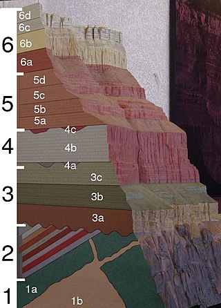
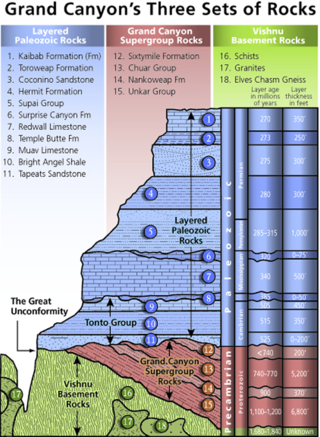
The geology of the Grand Canyon area includes one of the most complete and studied sequences of rock on Earth. The nearly 40 major sedimentary rock layers exposed in the Grand Canyon and in the Grand Canyon National Park area range in age from about 200 million to nearly 2 billion years old. Most were deposited in warm, shallow seas and near ancient, long-gone sea shores in western North America. Both marine and terrestrial sediments are represented, including lithified sand dunes from an extinct desert. There are at least 14 known unconformities in the geologic record found in the Grand Canyon.

Sir James Hall of Dunglass, 4th Baronet FRS FRSE was a Scottish geologist and geophysicist. He was a Member of Parliament for St. Michael's borough 1807–1812.

<span class="mw-page-title-main">Dunglass</span> Human settlement in Scotland

Dunglass is a hamlet in East Lothian, Scotland, lying east of the Lammermuir Hills on the North Sea coast, within the parish of Oldhamstocks. It has a 15th-century collegiate church, now in the care of Historic Scotland. Dunglass is the birthplace of Sir James Hall, an 18th-century Scottish geologist and geophysicist. The name Dunglass comes from the Brittonic for "grey-green hill".

<span class="mw-page-title-main">Great Unconformity</span> Gap in geological strata

Of the many unconformities (gaps) observed in geological strata, the term Great Unconformity is frequently applied to either the unconformity observed by James Hutton in 1787 at Siccar Point in Scotland, or that observed by John Wesley Powell in the Grand Canyon in 1869. Both instances are exceptional examples of where the contacts between sedimentary strata and either sedimentary or crystalline strata of greatly different ages, origins, and structure represent periods of geologic time sufficiently long to raise great mountains and then erode them away.

<span class="mw-page-title-main">Cockburnspath</span> Human settlement in Scotland

Cockburnspath is a village in the Scottish Borders area of Scotland. It lies near the North Sea coast between Berwick-upon-Tweed and Edinburgh. It is at the eastern extremity of the Southern Upland Way a long-distance footpath from the west to east coast of Scotland. It is also the termini of the Sir Walter Scott Way and the Berwickshire Coastal Path. At the nearby village of Cove, there is a small fishing harbour.

Plutonism is the geologic theory that the igneous rocks forming the Earth originated from intrusive magmatic activity, with a continuing gradual process of weathering and erosion wearing away rocks, which were then deposited on the sea bed, re-formed into layers of sedimentary rock by heat and pressure, and raised again. It proposes that basalt is solidified molten magma. The theory lead to plutonic (intrinsic) rock classification, which includes intrinsic igneous rocks such as gabbro, diorite, granite and pegmatite. The name plutonism references Pluto, the classical ruler of the underworld and the Roman god of wealth. A main reason Pluto was incorporated into the classification was due to the plutonic rocks commonly being present in gold and silver ore deposits (veins).

<span class="mw-page-title-main">Siccar Point</span> Peninsula in Scottish Borders, Scotland

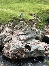
Siccar Point is a rocky promontory in the county of Berwickshire on the east coast of Scotland. It is famous in the history of geology for Hutton's Unconformity found in 1788, which James Hutton regarded as conclusive proof of his uniformitarian theory of geological development.

<span class="mw-page-title-main">Geology of Scotland</span> Overview of the geology of Scotland

The geology of Scotland is unusually varied for a country of its size, with a large number of different geological features. There are three main geographical sub-divisions: the Highlands and Islands is a diverse area which lies to the north and west of the Highland Boundary Fault; the Central Lowlands is a rift valley mainly comprising Palaeozoic formations; and the Southern Uplands, which lie south of the Southern Uplands Fault, are largely composed of Silurian deposits.

<span class="mw-page-title-main">Geology of Tasmania</span> Overview of the geology of Tasmania

The geology of Tasmania is complex, with the world's biggest exposure of diabase, or dolerite. The rock record contains representatives of each period of the Neoproterozoic, Paleozoic, Mesozoic and Cenozoic eras. It is one of the few southern hemisphere areas that were glaciated during the Pleistocene with glacial landforms in the higher parts. The west coast region hosts significant mineralisation and numerous active and historic mines.

<span class="mw-page-title-main">Isle of Arran</span> Island off the coast of Scotland

The Isle of Arran or simply Arran is an island off the west coast of Scotland. It is the largest island in the Firth of Clyde and the seventh-largest Scottish island, at 432 square kilometres (167 sq mi). Historically part of Buteshire, it is in the unitary council area of North Ayrshire. In the 2011 census it had a resident population of 4,629. Though culturally and physically similar to the Hebrides, it is separated from them by the Kintyre peninsula. Often referred to as "Scotland in Miniature", the Island is divided into highland and lowland areas by the Highland Boundary Fault and has been described as a "geologist's paradise".

Fujian is a south eastern coastal province of China. The eastern half of the province is largely covered by Jurassic Period acid volcanic rocks and Cretaceous tuffaceous sandstone. However, there are rocks of a variety of ages including the oldest around 1800 Ma. The deposits from the Triassic are predominantly on land, whereas the older ones are marine sediments.

<span class="mw-page-title-main">Unkar Group</span> Sequence of geologic strata of Proterozoic age

The Unkar Group is a sequence of strata of Proterozoic age that are subdivided into five geologic formations and exposed within the Grand Canyon, Arizona, Southwestern United States. The 5-unit Unkar Group is the basal member of the 8-member Grand Canyon Supergroup. The Unkar is about 1,600 to 2,200 m thick and composed, in ascending order, of the Bass Formation, Hakatai Shale, Shinumo Quartzite, Dox Formation, and Cardenas Basalt. Units 4 & 5 are found mostly in the eastern region of Grand Canyon. Units 1 through 3 are found in central Grand Canyon. The Unkar Group accumulated approximately between 1250 and 1104 Ma. In ascending order, the Unkar Group is overlain by the Nankoweap Formation, about 113 to 150 m thick; the Chuar Group, about 1,900 m (6,200 ft) thick; and the Sixtymile Formation, about 60 m (200 ft) thick. These are all of the units of the Grand Canyon Supergroup. The Unkar Group makes up approximately half of the thickness of the 8-unit Supergroup.

The geology of Nigeria formed beginning in the Archean and Proterozoic eons of the Precambrian. The country forms the Nigerian Province and more than half of its surface is igneous and metamorphic crystalline basement rock from the Precambrian. Between 2.9 billion and 500 million years ago, Nigeria was affected by three major orogeny mountain-building events and related igneous intrusions. Following the Pan-African orogeny, in the Cambrian at the time that multi-cellular life proliferated, Nigeria began to experience regional sedimentation and witnessed new igneous intrusions. By the Cretaceous period of the late Mesozoic, massive sedimentation was underway in different basins, due to a large marine transgression. By the Eocene, in the Cenozoic, the region returned to terrestrial conditions.

References

  1. Hutton, James (1788). "Theory of the Earth; or an Investigation of the Laws observable in the Composition, Dissolution, and Restoration of Land upon the Globe". Transactions of the Royal Society of Edinburgh. Royal Society of Edinburgh. 1 (Part 2): 209–304. doi:10.1017/S0080456800029227. S2CID   251578886.
  2. John McPhee, Annals of the Former World (Farrar, Straus and Giroux, 1998), p. 74.
  3. Concerning the System of the Earth Archived 2008-09-07 at the Wayback Machine abstract
  4. Kerr, Andrew (2020). "Classic Rock Tours 4. Long Walks, Lost Documents and the Birthplace of Igneous Petrology: Exploring Glen Tilt, Perthshire, Scotland". Geoscience Canada. The Geological Association of Canada. 47 (1): 83–102. doi: 10.12789/geocanj.2020.47.159 . Retrieved 3 April 2022.
  5. 1 2 3 4 Keith Montgomery (2003). "Siccar Point and Teaching the History of Geology" (PDF). University of Wisconsin. Archived from the original (PDF) on 25 October 2005. Retrieved 9 October 2020.
  6. "Hutton's Unconformity - Lochranza, Isle of Arran, UK - Places of Geologic Significance on Waymarking.com" . Retrieved 20 October 2008.
  7. "Arran – Hutton's Unconformity". scottishgeology.com. Retrieved 22 November 2012.
  8. "Hutton's Unconformity". Isle of Arran Heritage Museum. 18 July 2008. Archived from the original on 21 November 2008. Retrieved 20 October 2008.
  9. Hugh Rance (1999). "Hutton's unconformities" (PDF). Historical Geology: The Present is the Key to the Past. QCC Press. Archived from the original (PDF) on 3 December 2008. Retrieved 20 October 2008.
  10. Megarry, Jacquetta (2021). Arran Coastal Way (PDF). Rucksack Readers. p. 44. ISBN   978-1-913817-02-2.
  11. "Jedburgh Official Website". Hutton's Unconformity. Archived from the original on 2 February 2012. Retrieved 8 July 2011. Whilst visiting Allar's Mill on the Jed Water, Hutton was delighted to see horizontal bands of red sandstone lying 'unconformably' on top of near vertical and folded bands of rock.
  12. 1 2 Kerr, Andrew (2018). "Classic Rock Tours 1. Hutton's Unconformity at Siccar Point, Scotland: A Guide for Visiting the Shrine on the Abyss of Time". Geoscience Canada. The Geological Association of Canada. 45 (1): 27–42. doi: 10.12789/geocanj.2018.45.129 . Retrieved 21 March 2022.
  13. Claude C., Jr. Albritton (31 July 2012). The Abyss of Time: Unraveling the Mystery of the Earth's Age. Courier Corporation. p. xvi. ISBN   978-0-486-15116-8.
  14. "Hutton's Journeys to Prove his Theory". Archived from the original on 26 July 2011. Retrieved 21 September 2008.
  15. McKirdy, Alan Gordon, John & Crofts, Roger (2007) Land of Mountain and Flood: The Geology and Landforms of Scotland. Edinburgh. Birlinn. Page 253.
  16. Gillen, Con (2003) Geology and landscapes of Scotland. Harpenden. Terra Publishing. Page 95.
  17. John Playfair (1999). "Hutton's Unconformity". Transactions of the Royal Society of Edinburgh, vol. V, pt. III, 1805, quoted in Natural History, June 1999.
  18. Lothian and Borders GeoConservation Group (2015). "Hutton's Unconformity, Travel through the "abyss of time"" (PDF). Edinburgh Geological Society. Archived from the original (PDF) on 5 March 2016. Retrieved 31 August 2015.
  19. Browne, Michael; Smith, Richard; Aitken, Andrew M. (2002). "Stratigraphical framework for the Devonian (Old Red Sandstone) rocks of Scotland south of a line from Fort William to Aberdeen" (PDF). Research Report RR/01/004. Keyworth, Nottingham: British Geological Survey, Natural Environment Research Council: 48–50.