Koyambedu is a neighbourhood in Chennai, India. Situated in the western part of Chennai city, the Koyambedu area has become a major hub of activity in Chennai City after the inauguration of the Koyambedu market in 1996 and the Chennai Mofussil Bus Terminus (CMBT) in 2002. The area is active round the clock owing to the movement of people and goods through the day, with uninterrupted transport facilities such as long-route buses, autos, share autos, vegetable goods carriers and so forth.

Chennai Mofussil Bus Terminus, officially Puratchi Thalaivar Dr. M.G.R. Bus Terminus, is a bus terminus located in Chennai, India, providing inter-state bus transport services. It is located on the 100 feet (30 m) Jawaharlal Nehru Salai in Koyambedu between SAF Games Village and the Koyambedu Vegetable Market. It is the second largest bus terminus in India as well as Asia. Chennai Metro Rail has operated a coach depot behind the bus terminus since 2015.

Anna Nagar, is a neighbourhood in the metropolitan city of Chennai, India. Named after former chief minister of Tamil Nadu C. N. Annadurai, it is located in the north-western part of Chennai and forms a part of the Aminjikarai taluk and the Anna Nagar Zone. It is one of the prime residential areas in Chennai and is home to several prominent doctors, lawyers and politicians. Real estate prices are among the highest in the city. A recent addition to the area is VR Chennai Mall, located near Shanthi Colony and Thirumangalam junction.
Arumbakkam is a residential locality in Chennai.
Vandalur is a census town and taluk headquarters in the Chengalpattu district lying south of the metropolitan city of Chennai, India. Vandalur serves as the southern gateway to Chennai city. It has the Arignar Anna Zoological Park, which contain some rare species of wild flora and fauna. The town is served by Vandalur railway station of the Chennai Suburban Railway network.

Anna Salai, formerly known as St. Thomas Mount Road or simply Mount Road, is an arterial road in Chennai, India. It starts at the Cooum Creek, south of Fort St George, leading in a south-westerly direction towards St. Thomas Mount, and ends at the Kathipara Junction in Guindy. Beyond the Kathipara Junction, a branch road arises traversing westwards to Poonamallee to form the Mount-Poonamallee Road while the main branch continuing southwards to Chennai Airport, Tambaram and beyond to form Grand Southern Trunk Road. Anna Salai, which is more than 400 years old, is acknowledged as the most important road in Chennai city. The head offices of many commercial enterprises and public buildings are located along Anna Salai. It is the second longest road in Chennai, after EVR Periyar Salai.
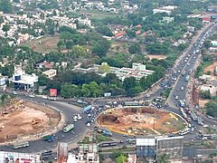
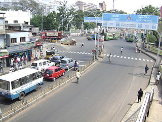
Koyambedu Junction, also called the Koyambedu Roundtana, is an important road junction in Chennai, Tamil Nadu, India. It is located north of the Chennai Mofussil Bus Terminus at the junction of the Inner Ring Road and the Poonamallee High Road (NH4) in the Koyambedu area/locality. The junction is a part of the Golden Quadrilateral project taken up under the National Highways Development Project.
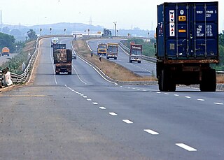
The Chennai Bypass Road is a full-access controlled expressway that interconnects four radial Indian National Highways around Chennai, India covering a distance of 32 km (20 mi) from Perungalathur on NH-32 to puzhal on NH-16 via Maduravoyal at a cost of ₹ 4.05 billion. Constructed as part of the National Highway Development Project to decongest the city of transiting vehicles, the expressway interconnects NH-32, NH-48, NH-716 and NH-16. This expressway now forms a part of the circular transportation corridor.
The city of Nagpur is strategically located in central India. It has a vast railway network and its road network is well-maintained to avoid congestion. There are 4 modes of transportation in Nagpur. Nagpur is connected to India's four major metropolitan areas by road, rail and air. Auto rickshaws operate in most parts of the city, and are the main form of hired transport.
The Chennai Port – Maduravoyal Expressway is a 20.6-kilometre (12.8 mi) long, six lane, double-decker elevated expressway under construction in the city of Chennai, Tamil Nadu, India. The corridor begins at Chennai Port Gate No. 10 and travels along the bank of the Cooum River till it reaches Koyambedu and along the median of NH 48 thereon till it reaches Maduravoyal.
The Padi Lucas Junction is the intersection of NH 205 and Inner Ring Road in the city of Chennai and is one of the most important junctions in the city. It is located in Anna Nagar north of Koyambedu Junction. An elevated rotary has been constructed at this junction as part of the NHDP by NHAI to ease the traffic congestion. It was built at a cost of ₹ 1,300 million and was opened for traffic on 20 February 2009.
Maduravoyal Junction is an important junction in Chennai. It is located to the west of Koyambedu Junction at the intersection of National Highway 4 (India) (NH4) and Chennai Bypass.
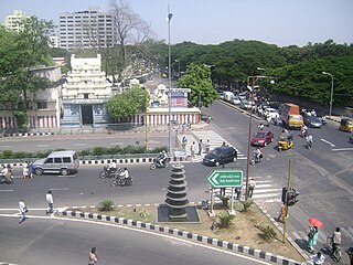
The Madhya Kailash Junction is an important junction in the southern part of the city of Chennai. It is located at the beginning of the Rajiv Gandhi Salai which intersects the Sardar Patel Road in the form of "T".

The Inner Ring Road (IRR), also known as Jawaharlal Nehru Salai or 100-Feet road or State Highway 2, is a major transportation corridor encircling the city of Chennai. It was developed by the Chennai Metropolitan Development Authority (CMDA). It is 25.2 km long with three distinct arms viz., Northern arm, Central arm and Southern arm, connecting SH 49A in Tiruvanmiyur, Velachery main road at Vijayanagar, NH 32 at Kathipara, NH 4 at Koyambedu, NH 205 at Padi, NH 5 at Madhavaram and joining SH 104 at Manali.
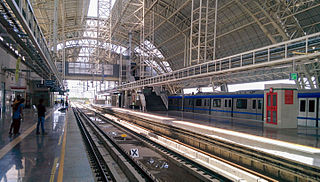
Koyambedu is an important elevated metro station on the South-East Corridor of the Green Line of Chennai Metro in Chennai, India. This station will serve the neighbourhoods of Koyambedu, Koyambedu vegetable market, and Koyambedu Private Bus Terminus.
EVR Periyar Salai (EVR High Road), earlier known as Poonamallee High Road(NH 48) and originally the Grand Western Trunk Road, is an arterial road in Chennai, India. It is the longest road in Chennai. Running from east to west, the 14-kilometre (8.7 mi) road starts at Muthuswamy Bridge near Madras Medical College at Park Town and ends near Maduravoyal Junction via Kilpauk, Aminjikarai, Anna Nagar Arch, Arumbakkam, Koyambedu. It further continues west towards Poonamallee and traverses the towns of Sriperumbudur, Walajapet, and Ranipet.
Moolakadai Junction is an important road junction in Chennai, India. It is located at Moolakadai at the intersection of the Grand Northern Trunk Road, Madhavaram High Road, Tondiarpet High Road, Kamaraj Road.

Vadapalani is an elevated metro station on the South-East Corridor of the Green Line of Chennai Metro in Chennai, India. This station serves the neighbourhoods of Vadapalani and Kodambakkam and is one of the major stations on the Koyambedu-Alandur stretch and became operational by early 2015.

Thirumangalam is an underground metro station on the South-East Corridor of the Green Line of Chennai Metro in Chennai, India. This station will serve the neighbourhoods where the old village of Thirumangalam once stood and now the area where the Thirumangalam Flyover, a prominent landmark and referred to by residents when giving directions.
The Red Line or Line 5 is one of the three lines of Chennai Metro, Phase 2 Project. The under construction line stretches from Madhavaram Milk Colony to Sholinganallur. The line will consist of 45 stations, of which 6 are underground, 1 is at grade and 38 are elevated. The government has announced feasibility studies to extend metro rail's corridor-5 from Koyambedu to Pattabiram via Thirumangalam, Mogappair, Ambattur and Avadi. At present, the proposed corridor-5 links Madhavaram with Sholinganallur via Koyambedu, Alandur and Madipakkam.