Kumbhalgarh

Last updated

Kumbhalgarh Fort
Native name
Rajasthani: कुम्भलगढ़ दुर्ग
Kumbhalgarh 055.jpg
Kumbhalgarh Fort
Type Fortress
Location Rajsamand district, Rajasthan, India
Coordinates 25°8′56″N73°34′49″E / 25.14889°N 73.58028°E / 25.14889; 73.58028
Area268 ha (1.03 sq mi) (662 acres)
Built15th century
TypeCultural
Criteriaii, iii
Designated 2013 (36th session)
Part of Hill Forts of Rajasthan
Reference no. 247
Country Flag of India.svg  India
Region South Asia
India Rajasthan location map.svg
Red pog.svg
Location of Kumbhalgarh Fort in Rajasthan
India location map.svg
Red pog.svg
Kumbhalgarh (India)

Kumbhalgarh (lit. "Kumbhal fort"), also known as the Great Wall of India, [1] is a fortress on the westerly range of Aravalli Hills in the Rajsamand district of the Rajasthan state in India.

Contents

Situated approximately 84 km (52 mi) from Udaipur, it was built during the 15th century by Rana Kumbha. [2] The wall of Kumbhalgarh is the second longest continuous wall in the world, spanning 38 kilometers, second only to the Great Wall of China. [3] [4] It is also the birthplace of great king and military leader Maharana Pratap of Mewar. [5]

In 2013, at the 37th session of the World Heritage Committee held in Phnom Penh, Cambodia, Kumbhalgarh Fort, along with five other forts of Rajasthan, was declared a UNESCO World Heritage Site under the group Hill Forts of Rajasthan. [6]

Etymology

The etymology of "Kumbhalgarh" originates from "Kumbha," denoting the ruler Rana Kumbha who constructed it, and "Garh," meaning fort. [7]

History

The early history of the fort could not be ascertained on account of lack of evidence. Before Rana Kumbha built the new fort, there was a small fort, limited to small hilly area, believed to have been built by King Samprati of the Maurya and was known as Matsyendra Durg. Rana Lakha won this entire area and plains of Godwar from Chauhan Rajputs of Nadol in late 14th century. [8]

Kumbhalgarh, as the fort we see it was built by Rana Kumbha who was the Rana of Mewar from the Sisodia rajput clan. Rana Kumbha took the aid of the famous architect of the era, "Mandan". Rana Kumbha's kingdom of Mewar stretched from Ranthambore to Gwalior and included large tracts of what is now Madhya Pradesh and Rajasthan. Out of the 84 forts in his dominion, Rana Kumbha is said to have built 32 of them, of which Kumbhalgarh is the largest and most elaborate. [9]

Kumbhalgarh also separated Mewar and Marwar from each other and was used as a place of refuge for the rulers of Mewar at times of danger. A notable instance was in the case of Prince Udai, the infant king of Mewar who was smuggled here in 1535, when Chittor was under siege. Prince Udai later succeeded to the throne. The fort remained impregnable to direct assault.[ citation needed ]

Ahmad Shah II of Gujarat attacked the fort in 1457, but found the effort futile. There was a local belief then that the Banmata deity in the fort protected it and hence he destroyed the temple. There were further attempts in 1458–59 and 1467 by Mahmud Khalji, but it also proved futile. Akbar's general, Shahbaz Khan, attacked this fort in October 1577 and after the siege of 6 months, he was able to capture the fort in April 1578. But it was recaptured by Pratap in 1583. In 1818, an armed band of sanyasis formed a garrison to protect the fort, but was convinced[ clarification needed ] by James Tod and the fort was taken over by the British and later returned to Udaipur State. There were additions made by Maharanas of Mewar, but the original structure built by Maharana Kumbha remains. The residential buildings and temples are well-preserved. [9] The fort is also known to be the birthplace of Maharana Pratap. [10]

Temple in Kumbalgarh fortress.JPG
Vedi Temple
Temple in Kumbalgarh fortress 01.JPG
Trikuta Temple, dedicated to Brahma, Vishnu and Shiva

Architecture

The massive gate of Kumbhalgarh fort, called the Ram Pol (Ram Gate) Ram Pol.jpg
The massive gate of Kumbhalgarh fort, called the Ram Pol (Ram Gate)

The chief architect who built this fort was Mandan, who documented his style of work in his text, Rajvallabh. [11] Built on a hilltop 1,100 m (3,600 ft) above sea level on the Aravalli range, the fort of Kumbhalgarh has perimeter walls that extend 36 km (22 mi), making it among the longest walls in the world. [12] The frontal walls are 4.5 m (15 ft). Kumbhalgarh has seven fortified gateways. There are over 360 temples within the fort, both Jain and Hindu Temples. [13] From the palace top, it is possible to see Kilometres into the Aravalli Range.

Important structures in the fort

Aerial view of Kumbhalgarh.jpg
Kumbhalgarh fort.JPG
Aerial view of a portion of the Kumbhalgarh wall

Aaret Pol was the first entry gate of the fort. Halla Pol is on the downward slope from the entrance. Just after Halla Pol is Badshahi Bavdi, a stepped tank, built after the invasion of Shahbaz Khan in 1578, the general of Mughal emperor Akbar to provide water to the troops. [14]

Hanuman Pol, the next gate is half a KM away from Halla Pol. Hanuman Pol is a double-storeyed gate with octagonal bastions. The gate got its name from the stone image of Hanuman located in front of the gate, which was brought by Maharana Kumbha. [15]

Ram Pol is the main entrance of the fort, there is another entrance towards the east, called Vijay Pol. [16]

There are five more gates between Ram Pol to Badal Mahal, the Palace built on the highest point of the fort. Names of these gates are Bhairon Pol, Nimboo Pol, Chaugan Pol, Pagda Pol and Ganesh Pol. [17]

Most buildings are visible from the Ram Pol. [ citation needed ]

Hindu Temple
Jain Temple

Culture

The Rajasthan Tourism Department organises a three-day annual festival in the fort in remembrance of the passion of Maharana Kumbha towards art and architecture. Sound and light shows are organised with the fort as the background. Various concerts and dance events are also organised to commemorate the function. The other events during the festival are Heritage Fort Walk, turban tying, tug-of war and mehendi mandana among others. [29]

Six forts of Rajasthan, namely, Amber Fort, Chittor Fort, Gagron Fort, Jaisalmer Fort, Kumbhalgarh and Ranthambore Fort were included in the UNESCO World Heritage Site list during the 37th meeting of the World Heritage Committee in Phnom Penh during June 2013. They were recognized as a serial cultural property and examples of Rajput military hill architecture. [30] [31]

This fort (Kumbhalgarh) is previously described as Wikisource-logo.svg The Fortress of Bowrie, in Rajpootana ., as painted by William Westall with an engraving in Fisher's Drawing Room Scrap Book, 1836 [32]

See also

Notes

  1. Pai, Sanjay A. "Kumbhalgarh, the Great Wall of India". Deccan Herald. Retrieved 18 March 2024.
  2. "Incredible India | Kumbhalgarh". www.incredibleindia.org. Retrieved 29 October 2021.
  3. Henbest, Nigel; Brew, Simon; Tomley, Sarah; Okona-Mensah, Ken; Parfitt, Tom; Davies, Trevor; Newkey-Burden, Chas (14 September 2023). The Colossal Book of Incredible Facts for Curious Minds: 5,000 staggering facts on science, nature, history, movies, music, the universe and more!. Octopus. ISBN   978-1-78840-470-9.
  4. "Incredible India | Kumbhalgarh". www.incredibleindia.org. Retrieved 12 February 2024.
  5. Mayur, Dan (12 November 2020). Global Nomad: Travels and Travails. Xlibris Corporation. ISBN   978-1-6641-3698-4.
  6. Centre, UNESCO World Heritage. "Hill Forts of Rajasthan". UNESCO World Heritage Centre. Retrieved 10 February 2024.
  7. "Kumbhalgarh Fort – History of Kumbhalgarh Fort, Rajasthan". www.tourmyindia.com. Retrieved 12 February 2024.
  8. Ram Vallabh Somani (2018). Garh ki Kahani, Garh ki Jubani. RG Group. p. 5. ISBN   9788186103487. , Kumbhalgarh, R.V. Somani
  9. 1 2 Verma, Amrit (2003). Forts of India. New Delhi: The Director, Publication Division, Ministry of Information and Broadcasting, Government of India. pp. 30–31. ISBN   81-230-1002-8.
  10. "The Fantastic 5 Forts: Rajasthan Is Home to Some Beautiful Forts, Here Are Some Must-See Heritage Structures". DNA : Daily News & Analysis. 28 January 2014. Archived from the original on 24 September 2015. Retrieved 5 July 2015.
  11. Pai, Sanjay A. "Kumbhalgarh, the Great Wall of India". Deccan Herald. Retrieved 10 February 2024.
  12. "View from the clouds". The Hindu. 7 May 2006. Retrieved 4 June 2015.
  13. ASI 2012, p 10
  14. Asawa 2004, pp. 13–15
  15. ASI 2012, p10
  16. ASI 2012, p10
  17. ASI 2012, p10
  18. Kumbhalgarh, ARCHAEOLOGICAL SURVEY OF INDIA, 2012 p.12
  19. Kumbhalgarh, ARCHAEOLOGICAL SURVEY OF INDIA, 2012 p.13
  20. Asawa 2004, p. 16
  21. Asawa 2004, pp. 18–19
  22. ASI 2012, p 16
  23. ASI 2012, p 19
  24. ASI 2012, p 17
  25. Tejas, Bharat (13 February 2024). "Story of Kumbhalgarh Fort" . Retrieved 27 February 2024.
  26. ASI 2012, p 15
  27. ASI 2012, p 16
  28. Asawa 2004, pp. 22–23
  29. "Kumbhalgarh Festival: It's Time to Gear Up, as This Cultural Fiesta, Held at One of the Most Famous and Historical Forts of Rajasthan, Is All Set to Open Its Doors to the Public". DNA : Daily News & Analysis. 28 January 2015. Archived from the original on 24 September 2015. Retrieved 5 July 2015.
  30. "Heritage Status for Forts". Eastern Eye. 28 June 2013. Archived from the original on 24 September 2015. Retrieved 5 July 2015.
  31. "Iconic Hill Forts on UN Heritage List". New Delhi, India: Mail Today. 22 June 2013. Archived from the original on 24 September 2015. Retrieved 5 July 2015.
  32. Landon, Letitia Elizabeth (1835). "picture". Fisher's Drawing Room Scrap Book, 1836. Fisher, Son & Co.Landon, Letitia Elizabeth (1835). "text". Fisher's Drawing Room Scrap Book, 1836. Fisher, Son & Co.

Related Research Articles

<span class="mw-page-title-main">Maharana Pratap</span> Rajput ruler of Mewar from 1572–1597

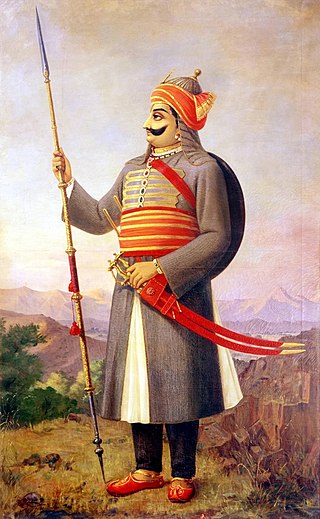
Pratap Singh I, popularly known as Maharana Pratap, was a king of Kingdom of Mewar, in north-western India in the present-day state of Rajasthan. He is notable for leading the Rajput resistance against the expansionist policy of the Mughal Emperor Akbar including the Battle of Haldighati.

<span class="mw-page-title-main">Chittorgarh</span> City in Rajasthan, India

Chittorgarh is a major city in the state of Rajasthan in western India. It lies on the Berach River, a tributary of the Banas, and is the administrative headquarters of Chittorgarh District. It was a major stronghold of the Rajput State of Medapata. The city of Chittorgarh is located on the banks of river Gambhiri and Berach.

<span class="mw-page-title-main">Mandore</span> Town in Rajasthan, India

Mandore is a suburb Historical town located 9 km north of Jodhpur city in Jodhpur district in the Indian state of Rajasthan.

<span class="mw-page-title-main">Jodha of Mandore</span> Rao of Marwar and founder of Jodhpur (1416–1489)

Rao JodhaRathore was the 15th Rajput chief of Rathore clan who ruled the Kingdom of Marwar in the present-day state of Rajasthan. He was the fifth son of Rao Ranmal. He is known for his illustrious military career and for founding the city of Jodhpur in 1459, which subsequently became the new capital of Marwar after Mandore.

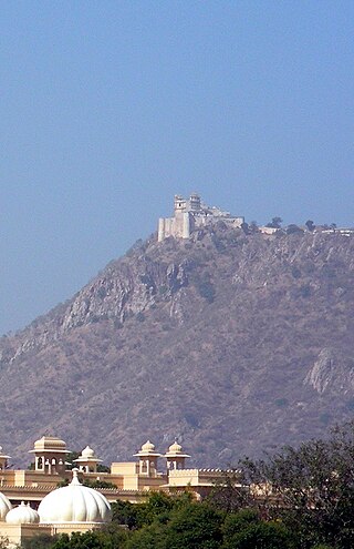
Gogunda is a town and tehsil headquarters of Gogunda Tehsil in Udaipur district, located about 35 km (22 mi) in north-west from Udaipur city in the Indian state of Rajasthan. It is situated on a high mountain in Aravalli hills and is reached by crossing a difficult mountain pass.

<span class="mw-page-title-main">Kumbha of Mewar</span> Maharana of Mewar from 1433–1468

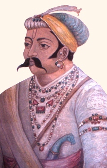
Rana Kumbha or Kumbhkaran Singh (1433–1468), popularly known as Maharana Kumbha, was the ruler of the Kingdom of Mewar. He belonged to the Sisodia clan of Rajputs. It was during his reign that Mewar became one of the most powerful political powers in northern India. He is considered to be the most powerful ruler of his time in India.

<span class="mw-page-title-main">Chittor Fort</span> Historic fort in Rajasthan, India

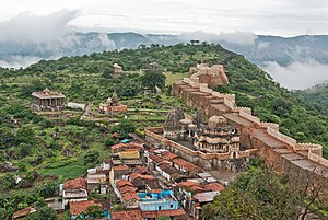
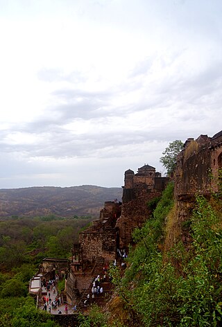
The Chittorgarh, also known as Chittod Fort, is one of the largest living forts in India. It is a UNESCO World Heritage Site. The fort was the capital of Mewar and is located in the present-day city of Chittorgarh. It sprawls over a hill 180 m (590.6 ft) in height spread over an area of 280 ha above the plains of the valley drained by the Berach River. The fort covers 65 historic structures, which include four palaces, 19 large temples, 20 large water bodies, 4 memorials and a few victory towers.

<span class="mw-page-title-main">Monsoon Palace</span> Palatial hilltop residence in Udaipur, Rajasthan

The Monsoon Palace, also known as the Sajjan Garh Palace, is a hilltop palatial residence in the city of Udaipur, Rajasthan in India, overlooking the Fateh Sagar Lake. It is named Sajjangarh after Maharana Sajjan Singh (1874–1884) of the Mewar dynasty, whom it was built for in 1884. The palace offers a panoramic view of the city's lakes, palaces and surrounding countryside. It was built chiefly to watch the monsoon clouds; hence, appropriately, it is popularly known as Monsoon Palace. It is said that the Maharana built it at the top of the hill to get a view of his ancestral home, Chittorgarh. Previously owned by the Mewar royal family, it is now under the control of the Forest Department of the Government of Rajasthan and has recently been opened to the public. The palace provides a beautiful view of the sunset.

<span class="mw-page-title-main">Ranthambore Fort</span> Fort in Sawai Madhopur, Rajasthan, India

Ranthambore Fort lies within the Ranthambore National Park, near the city of Sawai Madhopur in Sawai Madhopur district of Rajasthan, India. the park being the former hunting grounds of the Maharajahs of Jaipur until the time of India's Independence. It is a formidable fort having been a focal point of the historical developments of Rajasthan. The fort is believed to be constructed by numerous kings from Several Dynasties including The Yadavas, Chahamana Rajputs, Hada Rajputs, Mewar Rajput Kings and then the Delhi Sultanate captured it for a brief time. The fort provides a panoramic view of the surrounding Ranthambore National Park and is now a popular tourist attraction.

<span class="mw-page-title-main">Kingdom of Mewar</span> Kingdom in India (550s–1949)

The Kingdom of Mewar, also called Medapata, was an independent kingdom that existed in the Rajputana region of the Indian Subcontinent and later became a dominant state in medieval India. The kingdom was initially founded and ruled by the Guhila dynasty followed by the Sisodiya Dynasty. The earliest kingdom was centered around the south-central part of Rajasthan, state of India. It was bordered by the Aravali Range to the northwest, Ajmer to the north, Gujarat, Vagad and Malwa regions to the south and the Hadoti region to the east.

<span class="mw-page-title-main">City Palace, Udaipur</span> Building in Udaipur, India

City Palace, Udaipur is a palace complex situated in the city of Udaipur in the Indian state of Rajasthan. It was built over a period of nearly 400 years, with contributions from several rulers of the Mewar dynasty. Its construction began in 1553, started by Maharana Udai Singh II of the Sisodia Rajput family as he shifted his capital from the erstwhile Chittor to the newfound city of Udaipur. The palace is located on the east bank of Lake Pichola and has several palaces built within its complex.

Devi Garh Palace is a heritage hotel and resort, housed in the 18th-century Devi Garh palace in the village of Delwara. It was the royal residence of the rulers of Delwara principality, from the mid-18th century till the mid-20th century. Situated in the Aravalli hills, 28 km northeast of Udaipur, Rajasthan, Devigarh forms one of the three main passes into the valley of Udaipur.

<span class="mw-page-title-main">Tourism in Rajasthan</span> Overview of tourism in Rajasthan, India

Rajasthan is one of the most popular tourist destinations in India, for both domestic and international tourists. Rajasthan attracts tourists for its historical forts, palaces, art and culture with its slogan "Padharo Mhare Desh " The capital city, Jaipur, also known as Pink City, is a very popular tourist destination and is a part of the Golden Triangle. The Walled City of Jaipur is only the second Indian city to be recognized as a UNESCO World Heritage Site, after Ahmedabad.

<span class="mw-page-title-main">Hill Forts of Rajasthan</span> UNESCO World Heritage Site in northern India

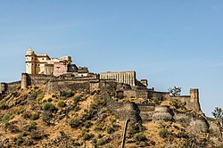
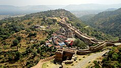
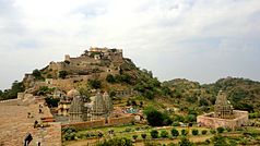
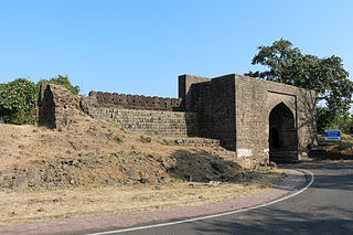
Hill Forts of Rajasthan are six forts, spread across Rajasthan state in northern India. They have been clustered as a series and designated as a UNESCO World Heritage Site in 2013. The hill forts series include—Chittor Fort at Chittorgarh, Kumbhalgarh Fort at Rajsamand, Ranthambore Fort at Sawai Madhopur, Gagron Fort at Jhalawar, Amer Fort at Jaipur and Jaisalmer Fort at Jaisalmer.

<span class="mw-page-title-main">Battle of Sarangpur</span>

The Battle of Sarangpur was fought between Rana Kumbha and Sultan Mahmud Khilji. Mahpa Panwar, who was one of the assassins of Rana Mokal, was sheltered by the Sultan of Mandu. A demand for this person was made by Rana Kumbha, but Mahmud Khilji refused to surrender the refugee. The Rana prepared for hostilities and advanced to attack Mandu. The Sultan advanced with a powerful army to meet Kumbha.

Delwara, nestled in the Aravalli Range hills, is a small town about 28 kms away from Udaipur, Mewar, and close to Eklingji Temple, on the way to the temple town of Nathdwara, in the state of Rajasthan, India. Delwara was originally known as ‘Devkul Patan Nagri’, which means the town of god. It boasted over 1500 temples at one time, out of which there were over 400 Jain temples. Delwara was the center of learning and culture before the 15th century AD. Around the middle of the 13th century, Raja Sagar, a Deora Chauhan and a descendant of Rao Kirtipal of Jalore, was a very brave king of Delwara (Mewar). Descendants of Raja Sagar sacrificed their lives whilst fighting alongside Ranas of Mewar against Muslim invaders. Raja Sagar was the progenitor of Bachhawat and Bothra clan of Oswals. Sagar's son, Kunwar Bohitya was immensely influenced and inspired by Jain philosophy. Samdhar, a grandson of Bohitya and a Deora Chauhan, was the first man in his genealogy to convert to Jainism.

Prithviraj Sisodia, generally known as Kunwar Prithviraj, was the eldest son of Maharana Raimal of Mewar and heir apparent of Mewar, of the Sisodia Rajputs. His mother was Jhali Rani Ratan Kanwar. His rapidity of moving from one place to another and lightning speed of attack earned him the title of Udno Prithviraj, the flying Prithviraj. He added the regions of Godwar and Ajmer to the territory of Mewar.

<span class="mw-page-title-main">Mewar-Malwa Conflict</span> Military conflict between the Kingdoms of Mewar and Malwa

The Mewar- Malwa conflict was a series of wars between the Kingdom of Mewar and the Islamic Sultanate of Malwa. The conflict erupted due to mutual territorial expansion triggered by both sides on each other. The war was fought in what is now known as the Indian states of Rajasthan and Madhya Pradesh. The Rana branch of the Guhilas, following their successful recovery of the Rajput stronghold of Chittorgarh and the entire region of Mewar alongside Rajputana after the Battle of Singoli, embarked on an ambitious expansion at the cost of their neighboring kingdoms. On the other side, with the invasion of Timur, the Lame Delhi Sultanate grew weak with its multiple subahs gaining independence which included Malwa, adjacent to Mewar.

References