See also
Rivers of India: Saraswathi, Kaveri, Ganga, Indus,Yamuna and so more...
| This Indian location article is a stub. You can help Wikipedia by expanding it. |
Rivers of India: Saraswathi, Kaveri, Ganga, Indus,Yamuna and so more...
| This Indian location article is a stub. You can help Wikipedia by expanding it. |

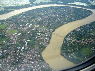
The Ganges, or Ganga, is a trans-boundary river of South Asia which flows through India and Bangladesh. The 2,601 km (1,616 mi) river originates from the Gangotri Glacier of western Himalayas in the Indian state of Uttarakhand, and flows south and east through the Gangetic Plain of India and Bangladesh, eventually emptying into the Bay of Bengal.

Haryana is one of the 28 states in India, located in the northern part of the country. It was carved out of the former state of East Punjab on 1 November 1966 on a linguistic basis. It is ranked 22nd in terms of area, with less than 1.4% of India's land area. Chandigarh is the state capital, Faridabad in National Capital Region is the most populous city of the state, and Gurugram is a leading financial hub of the NCR, with major Fortune 500 companies located in it. Haryana has 6 administrative divisions, 22 districts, 72 sub-divisions, 93 revenue tehsils, 50 sub-tehsils, 140 community development blocks, 154 cities and towns, 6,848 villages, and 6222 villages panchayats.

The Indus River is one of the longest rivers in Asia. It flows through China, India (Ladakh) and Pakistan. Originating in the Tibetan Plateau in the vicinity of Lake Manasarovar, the river runs a course through the Ladakh region of India, towards Gilgit-Baltistan and then flows in a southerly direction along the entire length of Pakistan to merge into the Arabian Sea near the port city of Karachi in Sindh. It is the longest river of Pakistan.

A valley is a low area between hills or mountains typically with a river running through it. In geology, a valley or dale is a depression that is longer than it is wide. The terms U-shaped and V-shaped are descriptive terms of geography to characterize the form of valleys. Most valleys belong to one of these two main types or a mixture of them, at least with respect to the cross section of the slopes or hillsides.

Madhya Pradesh is a state in central India. Its capital is Bhopal, and the largest city is Indore, with Jabalpur, Gwalior, Ujjain, Sagar being the other major cities. Madhya Pradesh is the second largest Indian state by area and the fifth largest state by population with over 75 million residents. It borders the states of Uttar Pradesh to the northeast, Chhattisgarh to the southeast, Maharashtra to the south, Gujarat to the west, and Rajasthan to the northwest. Before 2000, when Chhattisgarh was a part of Madhya Pradesh, Madhya Pradesh was the largest state in India and the distance between the two furthest points inside the state, Singoli and Konta, was 1500 km.

The Brahmaputra, called Yarlung Tsangpo in Tibet, Siang/Dihang River in Arunachal Pradesh and Luit,Dilao in Assam, is a trans-boundary river which flows through China, India and Bangladesh. It is the ninth largest river in the world by discharge, and the 15th longest.

Jharkhand is a state in eastern India. The state shares its border with the states of Bihar to the north, Uttar Pradesh to the northwest, Chhattisgarh to the west, Odisha to the south and West Bengal to the east. It has an area of 79,710 km2 (30,778 sq mi). It is the 15th largest state by area, and the 14th largest by population. Hindi is the official language of the state. The city of Ranchi is its capital and Dumka its sub capital. The state is known for its waterfalls, hills and holy places; Baidyanath Dham, Parasnath and Rajrappa are major religious sites.

The South Asian river dolphin is an endangered freshwater or river dolphin found in the region of Indian subcontinent, which is split into two subspecies, the Ganges river dolphin and the Indus river dolphin. The Ganges river dolphin is primarily found in the Ganges and Brahmaputra Rivers and their tributaries in India, Bangladesh, and Nepal, while the Indus river dolphin is now found only in the main channel of the Indus River in Pakistan and active channels connected to it between the Jinnah and Kotri barrages, and in the River Beas in Punjab in India. From the 1970s until 1998, they were regarded as separate species; however, in 1998, their classification was changed from two separate species to subspecies of a single species. The Ganges river dolphin has been recognized by the government of India as its National Aquatic Animal and is the official animal of the Indian city of Guwahati. The Indus river dolphin has been named as the National Mammal of Pakistan.

The Yamuna, also known as the Jumna or Jamna, is the second-largest tributary river of the Ganges (Ganga) and the longest tributary in India. Originating from the Yamunotri Glacier at a height of 6,387 metres (20,955 ft) on the southwestern slopes of Banderpooch peaks of the Lower Himalaya in Uttarakhand, it travels a total length of 1,376 kilometres (855 mi) and has a drainage system of 366,223 square kilometres (141,399 sq mi), 40.2% of the entire Ganges Basin. It merges with the Ganges at Triveni Sangam, Prayagraj, which is a site of the Kumbh Mela, a Hindu festival held every 12 years.

The Hooghly River or the Bhāgirathi-Hooghly, originally and in local tongues the 'Ganga', and also called Kati-Ganga, is an approximately 260-kilometre-long (160 mi) distributary of the Ganges River in West Bengal, India. The Ganges splits into the Padma and the Hooghly near Giria, Murshidabad. Today there is a further man-made bifurcation of the river upstream at Farakka. The Padma flows eastward into Bangladesh, whereas the Hooghly flows south through West Bengal. The river flows through the Rarh region, the lower deltaic districts of West Bengal, and eventually into the Bay of Bengal. The upper riparian zone of the river is called Bhagirathi while the lower riparian zone is called Hooghly. Major rivers that drain into the Bhagirathi-Hooghly include Mayurakshi, Jalangi, Ajay, Damodar, Rupnarayan and Haldi rivers other than the Ganges. Kolkata and Hugli-Chinsura, the headquarters of Hooghly (district), are located on the banks of this river.

The Koyna River is a tributary of the Krishna River which originates in Mahableshwar, Satara district, western Maharashtra, India. It rises near Mahabaleshwar, a famous hill station in the Western Ghats. Unlike most of the other rivers in Maharashtra which flow East-West direction, the Koyna river flows in North-South direction. The Koyna River is famous for the Koyna Dam and the Koyna Hydroelectric Project. Today the Koyna Hydroelectric Project is the largest completed hydroelectric project in India. The reservoir – Shivasagar Lake, is a huge lake of 50 km in length.

The Sutlej River is the longest of the five rivers that flow through the historic crossroads region of Punjab in northern India and Pakistan. The Sutlej River is also known as Satadree. It is the easternmost tributary of the Indus River.

The Ulhas River is a west flowing river in Western India in the state of Maharashtra draining an area of 4,637 km2.
The Barak River is a 900-kilometre-long (560 mi) river flowing through the states of Manipur, Nagaland, Mizoram and Assam in India and into the Bay of Bengal via Bangladesh. Of the 900 km, 524 km is in India, 31 km on Indo – Bangladesh border and the rest is in Bangladesh. The navigable portion of Barak River in India, the 121 km stretch between Lakhipur and Bhanga has been declared as National Waterway 6, (NW-6) in the year 2016. The river drains an area of 52,000 km2 (20,000 sq mi), of which 41,723 km2 (16,109 sq mi) lies in India which is nearly 1.38% of the total geographical area of the country. The environment of Barak's basin hosts a wide variety of flora and fauna.

The Kali River or Kali nadi is a river flowing through Uttara Kannada district of Karnataka state in India. The river rises near Diggi, a small village in Uttar Kannada district. The river is the lifeline to some 4 lakh people in the Uttara Kannada district and supports the livelihoods of tens of thousands of people including fishermen on the coast of Karwar. There are many dams built across this river for the generation of electricity. One of the important dams build across Kali river is the Supa Dam at Ganeshgudi. The river runs 184 kilometers before joining Arabian Sea.
The territorial disputes of India and Nepal include a few areas: the Kalapani territory, Kuthi Valley and Susta.
National Highway 333B, commonly referred to as NH 333B is a national highway in India. It is a spur road of National Highway 33. NH-333B traverses the state of Bihar in India.