List of extreme points of India

Last updated

The extreme points of India include the coordinates that are further north, south, east or west than any other location in India; and the highest and the lowest altitudes in the country. The northernmost point claimed by India is in territory disputed between India and Pakistan, and administered partially by both. With the exception of Kanyakumari (Cape Comorin), the southernmost location of mainland India, all other extreme locations are uninhabited.

Contents

The latitude and longitude are expressed in decimal degree notation, in which a positive latitude value refers to the northern hemisphere, and a negative value refers to the southern hemisphere. Similarly, a positive longitude value refers to the eastern hemisphere, and a negative value refers to the western hemisphere. The coordinates used in this article are sourced from Google Earth, which makes use of the WGS84 geodetic reference system. Additionally, a negative altitude value refers to land below sea level.

Extreme points

Extreme points of India marked on the map of India Extreme points of India en.svg
Extreme points of India marked on the map of India

The northernmost point claimed by India lies in the Pakistani-administered territory of Gilgit-Baltistan, which India claims as a part of the union territory of Ladakh. The northernmost point administered by India lies in the union territory of Ladakh, which is claimed by Pakistan as a part of the autonomous territory of Azad Kashmir. This list provides the northernmost point as claimed by India; the northernmost disputed point that is administered by India; and the northernmost undisputed point in India. This case also applies to the highest elevated regions.

India's easternmost state is Arunachal Pradesh. Part of the state is claimed by China as part of Tibet Autonomous Region, though administered by India, The easternmost of Indian-administered territory is located in this disputed region. [1] Consequently, this list mentions both the disputed and undisputed easternmost points in India.

All astronomical calculations are performed with respect to a Central Station at longitude 82°30’ East, latitude 23°11’ North.

HeadingLocationAdministrative entityBordering entityCoordinates [nb 1] Ref(s)
North
(disputed, administered)
East of Indira Col at Siachen Glacier Ladakh Xinjiang, China 35°40′28″N76°50′40″E / 35.674521°N 76.844485°E / 35.674521; 76.844485 (Near Indira Col (Northernmost — disputed, administered)) [2]
North
(disputed, claimed)
East of Kilik Pass in the Karakoram Mountains on Xinjiang-Gilgit-Baltistan border Gilgit-Baltistan, Pakistan Xinjiang, China 37°05′09″N74°42′10″E / 37.08586°N 74.70291°E / 37.08586; 74.70291 (Xinjian-Gilgit-Baltistan border) [3]
North (undisputed)North of Kang La at the northern end of Miyar Valley in Lahaul and Spiti district Himachal Pradesh Ladakh 33°15′22″N76°47′56″E / 33.25615°N 76.79877°E / 33.25615; 76.79877 (Near Kangla (Northernmost — undisputed)) [4]
South Indira Point on the southernmost end of Great Nicobar Island of the Nicobar Islands Andaman and Nicobar Islands Indian Ocean 6°44′48″N93°50′33″E / 6.74678°N 93.84260°E / 6.74678; 93.84260 (Indira Point (Southernmost)) [5] [6]
South (mainland) Cape Comorin near Kanyakumari Tamil Nadu Indian Ocean 8°04′08″N77°33′08″E / 8.06890°N 77.55230°E / 8.06890; 77.55230 (Cape Comorin (Southernmost — mainland) [5] [7]
East
(disputed, administered)
Southeast of Dong (before Kibithu in Anjaw district) Arunachal Pradesh Kachin State, Myanmar 28°00′42″N97°23′44″E / 28.01168°N 97.39564°E / 28.01168; 97.39564 (near Kibithu (Easternmost — disputed, administered)) [5] [8]
East (undisputed)Chaukan Pass, east of Vijaynagar in Changlang district Arunachal Pradesh Kachin State, Myanmar 27°08′10″N97°09′57″E / 27.13611°N 97.16575°E / 27.13611; 97.16575 (Near Vijaynagar (Easternmost — undisputed)) [9]
West Sir Creek in Kutch district Gujarat Indus River Delta, Sindh, Pakistan 23°37′34″N68°11′39″E / 23.6261°N 68.1941°E / 23.6261; 68.1941 (Ghuar Mota (Westernmost)) [10]

Altitudes

ExtremityNameAltitudeLocationStateCoordinatesRef(s)
Highest (undisputed) Kangchenjunga 8,586 m (28,169 ft) Eastern Himalaya on the India-Nepal border Sikkim 27°42′09″N88°08′54″E / 27.70250°N 88.14833°E / 27.70250; 88.14833 (West Sikkim (Highest — undisputed)) [5]
Highest (disputed, claimed) K2 8,611 m (28,251 ft) Karakoram on border between Gilgit-Baltistan (administered by Pakistan) and Xinjiang (administered by China)Gilgit-Baltistan, Pakistan 35°52′57″N76°30′48″E / 35.88250°N 76.51333°E / 35.88250; 76.51333 (Border between Kashmir and Xinjiang (Highest — disputed)) [5]
Highest
(undisputed and entirely within India)
Nanda Devi 7,816 m (25,643 ft) Garhwal Himalaya Uttarakhand 30°22′36″N79°58′15″E / 30.37667°N 79.97083°E / 30.37667; 79.97083 (Uttarakhand (Highest completely within India)) [5]
Lowest Kuttanad −2.2 m (−7.2 ft) Alappuzha district Kerala 9°09′13″N76°28′23″E / 9.15360°N 76.47300°E / 9.15360; 76.47300 (Kuttanad (Lowest)) [11]

See also

India related
Other related topics

Notes

  1. Coordinates obtained from Google Earth. Google Earth makes use of the WGS84 geodetic reference system.

Related Research Articles

<span class="mw-page-title-main">Tropic of Cancer</span> Line of northernmost latitude at which the Sun can be directly overhead

The Tropic of Cancer, also known as the Northern Tropic, is the northernmost circle of latitude on Earth at which the Sun is perceived to be directly overhead. This occurs on the June solstice, when the Northern Hemisphere is tilted toward the Sun to its maximum extent. It also reaches 90 degrees below the horizon at solar midnight on the December Solstice. Using a continuously updated formula, the circle is currently 23°26′10.1″ (or 23.43613°) north of the Equator.

The extreme points of Norway include the coordinates that are farther north, south, east or west than any other location in Norway; and the highest and the lowest altitudes in the country. The northernmost point is Rossøya on Svalbard, the southernmost is Pysen in Mandal, the easternmost is Kræmerpynten on Svalbard, and the westernmost is Hoybergodden on Jan Mayen. The highest peak is Galdhøpiggen, standing at 2,469 m (8,100 ft) above mean sea level, while the lowest elevation is sea level at the coast.

<span class="mw-page-title-main">Kathua</span> City administered by India in Jammu and Kashmir

Kathua is a city and municipal council of the Jammu division of Indian-administered Jammu and Kashmir in the disputed Kashmir region. The city is the headquarters of Kathua district and is divided into 27 wards which constitute the Kathua Municipal Council. It is situated along NH-44 The city has a bustling industrial area and an army cantonment adjoining it. Being a transit hub for industrial activity in the state, the city has a large industrial base with textile park, Biotechnology and Pharma industrial and research park, Cement industry and many medium scale MSMEs.

<span class="mw-page-title-main">Leh district</span> District of Ladakh, administered by India

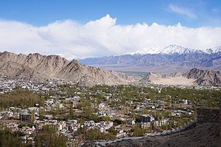
Leh district is a district in Indian-administered Ladakh in the disputed Kashmir-region. Ladakh is an Indian-administered union territory. With an area of 45,110 km2, it is the second largest district in the country, second only to Kutch. It is bounded on the north by Gilgit-Baltistan's Kharmang and Ghanche districts and Xinjiang's Kashgar Prefecture and Hotan Prefecture, to which it connects via the historic Karakoram Pass. Aksai Chin and Tibet are to the east, Kargil district to the west, and Lahul and Spiti to the south. The district headquarters is in Leh. It lies between 32 and 36 degree north latitude and 75 to 80 degree east longitude.

<span class="mw-page-title-main">Skardu District</span> District of Gilgit-Baltistan administered by Pakistan

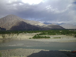
The Skardu District is a district of Pakistan-administered Gilgit-Baltistan in the disputed Kashmir region. Skardu District is bounded on the east by the Ghanche District, on the south by the Kharmang District, on the west by the Astore District, on the north-west by the Rondu District and on the north by the Shigar district. The district headquarters is the town of Skardu, which is also the division headquarters.

<span class="mw-page-title-main">Gilgit District</span> District of Gilgit-Baltistan in Pakistan

The Gilgit District is one of the 14 districts of Pakistan-administered territory of Gilgit-Baltistan in the disputed Kashmir region. The headquarters of the district is the town of Gilgit. At the 1998 census, the Gilgit District had a population of 243,324. The district includes Gilgit, the Bagrot Valley, Juglot, Danyore, Sultanabad, Naltar Peak, and the Nomal Valley. The highest peak in the district is Distaghil Sar 7,885 metres (25,869 ft), which is the seventh-highest peak in Pakistan and 19th highest in the world.

The extreme points of the Faroe Islands include the coordinates that are further north, south, east or west than any other location in the Faroe Islands; and the highest and the lowest elevations in the territory.

<span class="mw-page-title-main">Kupwara district</span> District of Jammu and Kashmir administered by India

Kupwara district is an administrative district of Indian-administered Jammu and Kashmir in the disputed Kashmir region. It is one of the 10 districts located in the Kashmir Valley Division of Indian administered Kashmir. The Pohru River and Mawar river are two main rivers in the district. Both of them meet Jhelum river in Baramulla district.

<span class="mw-page-title-main">Samba district</span> District of Jammu and Kashmir administered by India

Samba district is an administrative district in the Jammu division of Indian-administered Jammu and Kashmir in the disputed Kashmir region. It was formed in 2006. Before its formation, this area was part of Jammu district and Kathua district.

<span class="mw-page-title-main">Kulgam district</span> Kulgam, Jammu and Kashmir

Kulgam district is an administrative district of Indian-administered Jammu and Kashmir in the disputed Kashmir region. It is in the Kashmir division and is located at a distance of 18 kilometres (11 mi) towards south-west of Anantnag. The district comprises block, tehsil and town of Kulgam.

<span class="mw-page-title-main">Disputed territories of India</span>

There are several disputed territories of India. A territorial dispute is a disagreement over the possession or control of land between two or more states or over the possession or control of land by a new state and occupying power after it has conquered the land from a former state no longer currently recognized by the new state.

<span class="mw-page-title-main">Baltistan Division</span> Administrative division of Pakistan-administered Gilgit-Baltistan

Baltistan Division is a first-order administrative division of Pakistan-administered Gilgit-Baltistan in the disputed Kashmir region. It overlaps with the historical Baltistan region.

<span class="mw-page-title-main">Diamer Division</span> Administrative division of Gilgit-Baltistan, Pakistan

Diamer Division, also known as Diamer-Astore Division, is a first-order administrative division of Gilgit-Baltistan region in Pakistan.

References

  1. "Why China claims Arunachal Pradesh". Rediff.com. 2006-11-16. Archived from the original on 2008-06-17. Retrieved 2008-09-11.
  2. "Google Maps (Jammu and Kashmir)". Google. Archived from the original on 2014-06-14. Retrieved 2014-05-11.
  3. "Google Maps (Gilgit-Baltistan)". Google. Retrieved 2017-11-17.
  4. "Google Maps (Himachal Pradesh)". Google. Retrieved 2008-09-11.
  5. 1 2 3 4 5 6 Thomas (2003). Manorama Yearbook 2003. Malayala Manorama Co. Ltd. p. 649. ISBN   81-900461-8-7.
  6. "Google Maps (Kashmir)". Google. Retrieved 2008-09-11.
  7. "Google Maps (Tamil Nadu)". Google. Retrieved 2008-09-11.
  8. "Google Maps (Arunachal Pradesh)". Google. Retrieved 2008-09-11.
  9. "Google Maps (Arunachal Pradesh)". Google. Retrieved 2008-09-11.
  10. "Google Maps (Gujarat)". Google. Retrieved 2008-09-11.
  11. Suchitra, M (2003-08-13). "Thirst below sea level". The Hindu . Archived from the original on 2019-09-22. Retrieved 2014-05-11.