Loch Tummel

Last updated

Loch Tummel
Schotland Queen's View 8-05-2010 10-39-44.JPG
The 'Queen's View'
Perth and Kinross UK relief location map.jpg
Red pog.svg
Loch Tummel
Loch Rannoch shown within Perth and Kinross.
Location Perth and Kinross, Scotland
Coordinates 56°42′39″N3°55′44″W / 56.7107°N 3.9290°W / 56.7107; -3.9290
Type freshwater loch
Basin  countriesScotland
Max. length11 km (7 mi) [1]
Max. width0.95 km (0.59 mi) [1]
Surface area579.1 ha (1,431 acres) [2]
Max. depth44 m (145 ft) [1]
Shore length127.2 km (16.9 mi) [2]
Surface elevation142 m (466 ft) [2]
1 Shore length is not a well-defined measure.

Loch Tummel (Scottish Gaelic: Loch Teimheil) is a long, narrow loch, seven kilometres (4+12 miles) northwest of Pitlochry in the council area of Perth and Kinross, Scotland. It is fed and drained by the River Tummel, which flows into the River Tay about 13 km (8 mi) south-east of the Clunie Dam at the loch's eastern end. [3] [4] [2]

Contents

The loch is traversed by roads to both north and south. Along the northern side the road is numbered as the B8019, and runs from the Pass of Killiecrankie on the A9 in the east to Tummel Bridge at the head of the loch. The road on the southern side is unclassified, and meets the A9 further south, near to Pitlochry. [3]

The loch gives its name to the Loch Tummel National Scenic Area (NSA), one of 40 such areas in Scotland, which are defined so as to identify areas of exceptional scenery and to ensure its protection by restricting certain forms of development. [5] The Loch Tummel Lyon NSA covers 9,013 hectares (22,272 acres), all of which lies within Perth and Kinross. [6] The NSA covers the hills surrounding the loch, and extends along the River Tummel to also take in the area surrounding the Pass of Killiecrankie on the River Garry. [7]

Leisure and tourism

Loch Tummel is popular with anglers who fish for brown trout and pike. Fishing is managed by the Loch Rannoch Conservation Association, who issue permits and control catches. [8] Loch Tummel Sailing Club is based at Foss on the south west shore of the loch. [9] The loch is also very popular with campers during the spring and summer. [1] The roads on either side of the loch both offer splendid views of the surrounding countryside, [1] especially from the well-known 'Queen's View' from the north shore, which was made famous by Queen Victoria in 1866. This viewpoint offers a magnificent vista over the loch with Schiehallion in the background. It is also claimed that the view was originally named after Queen Isabel, wife of Robert the Bruce, who is said to have hidden in the nearby woods after the Bruce's defeat at the Battle of Methven in 1306. [10] [11]

Areas of forestry around Loch Tummel owned by Forestry and Land Scotland (FLS) form part of the Tay Forest Park, a network of FLS forests spread across the Highland parts of Perthshire that are managed to provide walks and amenities for visitors. [10]

Nature and conservation

Loch Tummel National Scenic Area
Loch Tummel NSA.png
A map showing the extent of the Loch Tummel National Scenic Area.
Location 56°42′40″N3°55′40″W / 56.71111°N 3.92778°W / 56.71111; -3.92778
Area90.1 km2 (34.8 sq mi) [6]
Established1981
Governing body NatureScot

The River Tummel is a tributary of the River Tay, and Loch Tummel is included as part of the River Tay Special Area of Conservation. The designation notes the river system's importance for salmon, otters, brook lampreys, river lampreys and sea lampreys. [12] Brown trout and pike are also present in the loch. [8]

The woods to the north of the loch are home to a number of protected species, including capercaillie, black grouse, red squirrel, pearl-bordered fritillary and juniper. [13]

Hydro-electricity

Loch Tummel from the Queen's View in about 1895. Note the lower water level when compared to the modern image. (Loch Tummel, Queen's View, Scotland) (LOC) (3449506779).jpg
Loch Tummel from the Queen's View in about 1895. Note the lower water level when compared to the modern image.

Loch Tummel became part of the Tummel Hydro-Electric Power Scheme when the Clunie Dam was constructed by Wimpey Construction at its eastern end in 1950, [14] raising the water level by 4.5 m (15 ft). [1] Prior to this the loch, which is now approximately 11 km (7 mi) long and just under 0 km (1 mi) wide was much smaller, being 4.4 km (2+34 mi) long and 0.8 km (12 mi) wide. [4]

Water from Loch Tummel is diverted to Loch Faskally, running via Clunie power station, which has a vertical head of 53 m (174 ft) and a total generating capacity of 61  MW. There is also a power station at Tummel Bridge at the western end of the loch that takes water from Dunalastair reservoir below Loch Rannoch, and discharges into Loch Tummel: this station has a vertical head of 53 m (174 ft) and a total generating capacity of 34 MW. [15]

Historical sites

The northern side of the loch has many archeological sites, including an Iron Age ring fort, abandoned townships, [13] and the remains of Pictish fortified villages. [1] This area also includes the standing stones of Clachan Aoraidh, located at the head of Glen Fincastle in the Allean Forest. [16] Fincastle House, a 17th-century Category A listed building, sits at the eastern end of the strath. [17]

The raising of the loch for hydroelectricity led to the drowning of an artificial island of a type known as a crannog lying off Port an Eilean on the northern side of the loch. The island is now 3 m underwater, and was investigated by the Scottish Trust for Underwater Archaeology and Perth & Kinross Heritage Trust in 2004. A well-made flagstone floor and a flight of steps that led down a distance of 2 m to the loch bed were found. Analysis of one of the timbers found on the site revealed that it dated from around 1840. [18]

Above the head of the loch, there are two bridges over the River Tummel at Tummel Bridge. The original humpbacked bridge was built by General Wade in about 1734 [19] as part of his construction of some 240 miles (390 km) of roads and 30 bridges in Scotland between 1725 and 1737. [20] A modern replacement alongside Wade's bridge carries the traffic from Aberfeldy on the B846 road. [3] The historic drove road of the Road to the Isles leaves Wade's military road at Tummel Bridge, from where it heads west into Lochaber, [21] and Tummel is one of the places mentioned in the Scottish folk song named after the road. [22]

See also

Related Research Articles

<span class="mw-page-title-main">Perthshire</span> Historic administrative division in Scotland

Perthshire, officially the County of Perth, is a historic county and registration county in central Scotland. Geographically it extends from Strathmore in the east, to the Pass of Drumochter in the north, Rannoch Moor and Ben Lui in the west, and Aberfoyle in the south; it borders the counties of Inverness-shire and Aberdeenshire to the north, Angus to the east, Fife, Kinross-shire, Clackmannanshire, Stirlingshire and Dunbartonshire to the south and Argyllshire to the west. It was a local government county from 1890 to 1930.

<span class="mw-page-title-main">Perth and Kinross</span> Council area of Scotland

Perth and Kinross is one of the 32 council areas of Scotland and a lieutenancy area. It borders onto the Aberdeenshire, Angus, Argyll and Bute, Clackmannanshire, Dundee, Fife, Highland and Stirling council areas. Perth is the administrative centre. With the exception of a large area of south-western Perthshire, the council area mostly corresponds to the historic counties of Perthshire and Kinross-shire.

<span class="mw-page-title-main">River Tay</span> Longest river in Scotland

The River Tay is the longest river in Scotland and the seventh-longest in Great Britain. The Tay originates in western Scotland on the slopes of Ben Lui, then flows easterly across the Highlands, through Loch Dochart, Loch Iubhair and Loch Tay, then continues east through Strathtay, in the centre of Scotland, then southeasterly through Perth, where it becomes tidal, to its mouth at the Firth of Tay, south of Dundee. It is the largest river in the United Kingdom by measured discharge. Its catchment is approximately 2,000 square miles, the Tweed's is 1,500 sq mi (3,900 km2) and the Spey's is 1,097 sq mi (2,840 km2).

<span class="mw-page-title-main">Pitlochry</span> Town in Perthshire, Scotland

Pitlochry is a town in the Perth and Kinross council area of Scotland, lying on the River Tummel. It is historically in the county of Perthshire, and has a population of 2,776, according to the 2011 census.

<span class="mw-page-title-main">Loch Rannoch</span> Freshwater loch in Perth and Kinross, Scotland

Loch Rannoch is a freshwater loch in Perth and Kinross, Scotland. It is over 15 kilometres (9.3 mi) long in a west–east direction with an average width of about 1.2 kilometres (0.75 mi), and is deepest at its eastern end, reaching a depth of 130 metres (440 ft). The River Tummel begins at its eastern end, where the small village of Kinloch Rannoch can be found, whilst the wild expanse of Rannoch Moor extends to the west of the loch. The area surrounding Loch Rannoch, along with Rannoch Moor itself, was formerly part of the native Caledonian Forest that stretched across much of Northern Scotland. Native forest is now largely absent from much of the area, due partly to logging, and partly to the climate becoming wetter, and Loch Rannoch is now largely surrounded by commercial forestry and open hillsides, although a small area remains at the Black Wood of Rannoch on the southern shore of the loch.

Rannoch is an area of the Scottish Highlands between the A9 road, to the east, and the A82, to the west. The area is crossed from south to north by the West Highland railway line.

<span class="mw-page-title-main">Aberfeldy, Perth and Kinross</span> Human settlement in Scotland

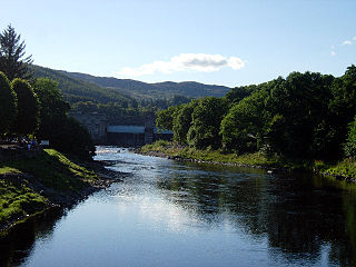
Aberfeldy is a burgh in Perth and Kinross, Scotland, on the River Tay. A small market town, Aberfeldy is located in Highland Perthshire. It was mentioned by Robert Burns in the poem The Birks Of Aberfeldy and in the Ed Sheeran song The Hills of Aberfeldy.

<span class="mw-page-title-main">Pass of Killiecrankie</span>

Three miles north of Pitlochry by the A9 road, the Pass of Killiecrankie, is a gorge lying between Ben Vrackie and Tenandry Hill in Perth and Kinross on the River Garry.

<span class="mw-page-title-main">River Tummel</span> River in Perth and Kinross, Scotland

The River Tummel is a river in Perth and Kinross, Scotland. Water from the Tummel is used in the Tummel hydro-electric power scheme, operated by SSE.

<span class="mw-page-title-main">Loch Faskally</span> Reservoir in Perth and Kinross, Scotland

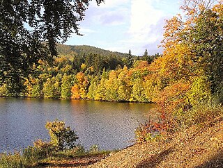
Loch Faskally is a man-made reservoir in Perth and Kinross, Scotland, 2.5 kilometres (1.6 mi) northwest of Pitlochry.

<span class="mw-page-title-main">Kinloch Rannoch</span> Human settlement in Scotland

Kinloch Rannoch is a village in Perth and Kinross, Scotland, at the eastern end of Loch Rannoch, 18 miles (29 km) west of Pitlochry, on the banks of the River Tummel. The village is a tourist and outdoor pursuits centre. It has a small population and is fairly remote.

<span class="mw-page-title-main">Tummel hydro-electric power scheme</span> Dam in Perth and Inverness

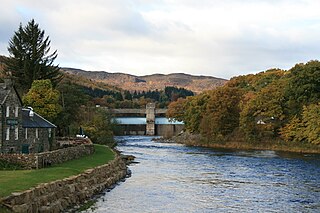
The Tummel hydro-electric power scheme is an interconnected network of dams, power stations, aqueducts and electric power transmission in the Grampian Mountains of Scotland. Roughly bounded by Dalwhinnie in the north, Rannoch Moor in the west and Pitlochry in the east it comprises a water catchment area of around 1,800 square kilometres and primary water storage at Loch Ericht, Loch Errochty, Loch Rannoch and Loch Tummel, in Perth and Kinross. Water, depending on where it originates and the path it takes, may pass through as many as five of the schemes nine power stations as it progresses from north-west to south-east. The scheme was constructed in the 1940s and 50s incorporating some earlier sites. It is managed by SSE plc.

<span class="mw-page-title-main">Dunalastair Water</span> Freshwater loch, reservoir in Perth and Kinross, Scotland

Dunalastair Water is an entirely man made reservoir in Scotland which lies between Loch Rannoch and Loch Tummel in Strath Tummel in Perth and Kinross council area. The loch provides water power for the Tummel hydroelectricity power station and has the reputation as one of the best wild trout fishing locations in the United Kingdom.

<span class="mw-page-title-main">Military roads of Scotland</span>

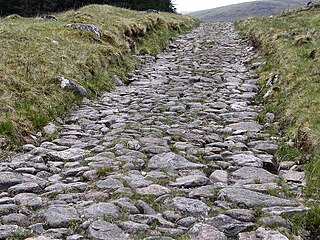
A network of military roads, sometimes called General Wade's Military Roads, was constructed in the Scottish Highlands during the middle part of the 18th century as part of an attempt by the British Government to bring order to a part of the country which had risen up in the Jacobite rebellion of 1715.

<span class="mw-page-title-main">Ben Nevis and Glen Coe National Scenic Area</span>

Ben Nevis and Glen Coe is a national scenic area (NSA) covering part of the Highlands of Scotland surrounding Ben Nevis and Glen Coe, in which certain forms of development are restricted. It is one of 40 such areas in Scotland, which are defined so as to identify areas of exceptional scenery and to ensure its protection from inappropriate development. The Ben Nevis and Glen Coe NSA covers 903 km2 (349 sq mi) of land, lying within the Highland, Argyll and Bute and Perth and Kinross council areas. A further 19 km2 (7.3 sq mi) of the NSA are marine, covering the sea loch of Loch Leven.

<span class="mw-page-title-main">Loch Rannoch and Glen Lyon National Scenic Area</span>

The Loch Rannoch and Glen Lyon National Scenic Area is a national scenic area (NSA) covering the area surrounding Loch Rannoch, Glen Lyon, and the Ben Lawers ranges of mountains in Scotland. It is one of 40 such areas in Scotland, which are defined so as to identify areas of exceptional scenery and to ensure its protection from inappropriate development by restricting certain forms of development. The Loch Rannoch and Glen Lyon NSA covers 48,625 ha, most of which lies in the council area of Perth and Kinross, with a small portion lying in Stirling.

<span class="mw-page-title-main">Tay Forest Park</span>

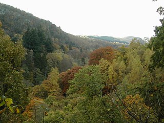
Tay Forest Park is a forest park in the council area of Perth and Kinross in Scotland. It consists of a network of forests managed by Forestry and Land Scotland (FLS) that are spread across the Highland parts of Perthshire, and covers 194 km2 (75 sq mi) in total. The park contains a series of disparate woods that are managed for multiple benefits, with an emphasis on recreation facilities for visitors.

<span class="mw-page-title-main">Ballechin Wood</span>

Ballechin Wood is a large coniferous forest site, around 805 acres (326 ha) in area, located above Ballechin in Perth and Kinross, Scotland. It is located a short distance northwest of where the River Tay and River Tummel merge at Balmacneil and around 2 miles (3.2 km) south of Pitlochry. The wood merges into Clunie Wood to the northwest and Logierait Wood to the southeast.

References

  1. 1 2 3 4 5 6 7 Tom Weir. The Scottish Lochs. pp. 77. Published by Constable and Company, 1980. ISBN   0-09-463270-7
  2. 1 2 3 4 "Loch Tummel". British Lakes. Archived from the original on 24 July 2018. Retrieved 24 July 2018.
  3. 1 2 3 Ordnance Survey. Explorer Map 1:25000. Sheet OL49, Pitlochry & Loch Tummel.
  4. 1 2 John, Murray; Lawrence, Pullar (1910). Bathymetrical Survey of the Fresh-Water Lochs of Scotland, 1897-1909 Lochs of the Tay Basin Volume II - Loch Tumme. National Library of Scotland: National Challenger Officer. p. 78. Retrieved 24 July 2018.PD-icon.svg This article incorporates text from this source, which is in the public domain .
  5. "National Scenic Areas". NatureScot. Retrieved 6 October 2020.
  6. 1 2 "National Scenic Areas - Maps". Scottish Natural Heritage. 20 December 2010. Archived from the original on 12 June 2018. Retrieved 2 May 2018.
  7. "Loch Tummel National Scenic Area". NatureScot. Retrieved 6 October 2020.
  8. 1 2 "Fishing around Rannoch and Tummel". Loch Rannoch Conservation Association. 2016. Retrieved 1 May 2018.
  9. "Where are we". Loch Tummel Sailing Club. 2015. Retrieved 2 May 2018.
  10. 1 2 "Tay Forest Park: Tall Trees & Big Views" (PDF). Forestry and Land Scotland. Retrieved 7 July 2020.
  11. "The special qualities of the National Scenic Areas" (PDF). Scottish Natural Heritage. 2010. pp. 125–120. Retrieved 24 January 2018.
  12. "River Tay SAC". NatureScot. Retrieved 6 October 2020.
  13. 1 2 "North Tummel Land Management Plan" (PDF). Forestry and Land Scotland. Retrieved 6 October 2020.
  14. White, Valerie (1980). Wimpey: The first hundred years. George Wimpey. p. 29.
  15. "Power from the Glens/Neart nan Gleann" (PDF). Scottish Hydro Electric. pp. 18–19. Retrieved 2 May 2018.
  16. "Na Clachan Aoraidh". Historic Environment Scotland. Retrieved 2 May 2018.
  17. "Old Fincastle House". Historic Environment Scotland. Retrieved 2 May 2018.
  18. "Loch Tummel: Crannog (Period Unassigned)(Possible)". Historic Environment Scotland. Retrieved 2 May 2018.
  19. "Canmore Archaeology Notes (Tummel Old Bridge)". Historic Environment Scotland. Retrieved 2 May 2018.
  20. "George Wade". Oxford Dictionary of National Biography. Retrieved 5 May 2012.
  21. "Kinloch Rannoch". Undiscovered Scotland. Retrieved 11 May 2018.
  22. "Lyrics - Road to the Isles". www.scottish-folk-music.com. 2011. Retrieved 26 April 2018.