McConnellsburg, Pennsylvania | |
---|---|
Etymology: Daniel McConnell | |
Coordinates: 39°55′58″N77°59′46″W / 39.93278°N 77.99611°W | |
Country | United States |
State | Pennsylvania |
County | Fulton County |
Founded | 1786-04-20 |
Government | |
• Mayor | Jeremy A Hollinshead |
Area | |
• Total | 0.35 sq mi (0.90 km2) |
• Land | 0.35 sq mi (0.90 km2) |
• Water | 0.00 sq mi (0.00 km2) |
Elevation | 892 ft (272 m) |
Population | |
• Total | 1,151 |
• Density | 3,317.00/sq mi (1,279.31/km2) |
Time zone | UTC-4 (EST) |
• Summer (DST) | UTC-5 (EDT) |
ZIP code | 17233 |
Area codes | 717 |
FIPS code | 42-46000 |
McConnellsburg is a borough and the county seat of Fulton County, Pennsylvania, United States. The population was 1,150 at the 2020 census. [3]
The McConnellsburg Historic District was recognized by the United States Department of the Interior in 1993 when it was listed in the National Register of Historic Places. The district consists of 144 structures that contribute to its historic character. Of notable meaning are the numerous taverns, inns, automotive garages and other travel-related structures still in existence today, which includes the Fulton House, the Fulton County Courthouse, and the log cabin of Daniel McConnell, who laid out the borough on April 20, 1786. It was further incorporated on March 26, 1814.
Currently McConnellsburg's largest economic driver is Oshkosh Corporation-owned JLG Industries, a major manufacturer of construction and maintenance access-related lifting equipment such as boomlifts, etc.
McConnellsburg is located in eastern Fulton County at 39°55′58″N77°59′46″W / 39.93278°N 77.99611°W (39.932673, -77.995986). [4]
According to the United States Census Bureau, the borough has a total area of 0.35 square miles (0.9 km2), all land. [5] The elevation in the center of town is 896 feet (273 m) above sea level.
The borough is located in the Ridge and Valley section of the Appalachian Mountains in southern Pennsylvania. It is situated in a 2-mile-wide (3 km) valley between Tuscarora Mountain to the east and Little Scrub Ridge and Meadow Grounds Mountain to the west.
U.S. Route 522 passes north–south through the center of town as Second Street. The main east–west street through the town center is Lincoln Way, or old U.S. Route 30 (the Lincoln Highway). U.S. Route 30 now bypasses the borough on a limited access highway to the north. The west end of Pennsylvania Route 16 is in McConnellsburg, following Lincoln Way and then the Buchanan Trail southeast out of town.
Via US 522 it is 24 miles (39 km) south to Hancock, Maryland, and 9 miles (14 km) north to the Pennsylvania Turnpike. US 30 leads east 21 miles (34 km) to Chambersburg and 19 miles (31 km) west to Breezewood. PA 16 leads southeast 10 miles (16 km) to Mercersburg and 20 miles (32 km) to Greencastle.
Census | Pop. | Note | %± |
---|---|---|---|
1850 | 477 | — | |
1860 | 556 | 16.6% | |
1870 | 552 | −0.7% | |
1880 | 584 | 5.8% | |
1890 | 594 | 1.7% | |
1900 | 576 | −3.0% | |
1910 | 579 | 0.5% | |
1920 | 689 | 19.0% | |
1930 | 768 | 11.5% | |
1940 | 1,055 | 37.4% | |
1950 | 1,136 | 7.7% | |
1960 | 1,245 | 9.6% | |
1970 | 1,228 | −1.4% | |
1980 | 1,178 | −4.1% | |
1990 | 1,106 | −6.1% | |
2000 | 1,073 | −3.0% | |
2010 | 1,220 | 13.7% | |
2020 | 1,150 | −5.7% | |
2021 (est.) | 1,141 | [3] | −0.8% |
Sources: [6] [7] [8] [2] |
As of the census [7] of 2000, there were 1,073 people, 506 households, and 271 families residing in the borough. The population density was 2,998.2 inhabitants per square mile (1,157.6/km2). There were 551 housing units at an average density of 1,539.6 per square mile (594.4/km2). The racial makeup of the borough was 97.02% White, 0.84% African American, 0.19% Native American, 0.09% Asian, 0.09% Pacific Islander, and 1.77% from two or more races. Hispanic or Latino of any race were 0.56% of the population.
There were 506 households, out of which 22.9% had children under the age of 18 living with them, 37.7% were married couples living together, 12.1% had a female householder with no husband present, and 46.4% were non-families. 42.1% of all households were made up of individuals, and 21.3% had someone living alone who was 65 years of age or older. The average household size was 2.01 and the average family size was 2.72.
In the borough the population was spread out, with 19.9% under the age of 18, 6.9% from 18 to 24, 24.9% from 25 to 44, 20.4% from 45 to 64, and 28.0% who were 65 years of age or older. The median age was 44 years. For every 100 females there were 80.0 males. For every 100 females age 18 and over, there were 75.9 males.
The median income for a household in the borough was $25,987, and the median income for a family was $33,125. Males had a median income of $28,478 versus $20,577 for females. The per capita income for the borough was $16,884. About 14.9% of families and 17.3% of the population were below the poverty line, including 31.7% of those under age 18 and 14.9% of those age 65 or over.
Newspaper: The Fulton County News
Television
McConnellsburg, and the rest of Fulton County, are located in the Washington, D.C. television market, but also are covered by Altoona and Harrisburg channels-but stations are difficult to catch with an antenna, requiring cable or satellite. An antenna can, however, sometimes get stations based out of the Hagerstown sub-market, such as WDVM and WWPB.
Local stations include
The CW: WDCW, WHP-DT3
MyNetworkTV: WDCA, WHP-DT2
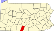
Fulton County is a county in the Commonwealth of Pennsylvania. As of the 2020 census, the population was 14,556, making it the fourth-least populous county in Pennsylvania. Its county seat is McConnellsburg. The county was created on April 19, 1850, from a part of Bedford County and named after inventor Robert Fulton.
Christiana is a borough in Lancaster County, Pennsylvania, United States. The population was 1,100 at the time of the 2020 census.
Conewago Township is a township in Adams County, Pennsylvania, United States. The population was 7,875 at the 2020 census.
Littlestown is a borough in Adams County, Pennsylvania, United States. The population was 4,782 at the 2020 census.
Loretto is a borough in Cambria County, Pennsylvania, United States. As of the 2010 census it had a population of 1,302. Like the rest of Cambria County, it is part of the Johnstown, Pennsylvania Metropolitan Statistical Area. Loretto is the home of Saint Francis University.
Emporium is a borough and the county seat of Cameron County in the U.S. state of Pennsylvania. It is located 100 miles (160 km) west-northwest of Williamsport. Early in the twentieth century, there were large power plants and manufacturers of radio tubes and incandescent lamps, paving brick, flour, iron, lumber, and sole leather. In 1900, 2,463 people lived in Emporium, and in 1910, the population was 2,916. By 2010, the population had dropped to 2,073, and at the 2020 census, the population was 1,961.
Parkesburg is a borough in Chester County, Pennsylvania, United States. The population was counted as 3,866 at the 2020 census. The ZIP code is 19365.
Newburg is a borough in Cumberland County, Pennsylvania, United States. The population was 336 at the 2010 census. It is part of the Harrisburg–Carlisle metropolitan statistical area.
Newville is a borough in Cumberland County, Pennsylvania, United States. The borough is located west of Carlisle. The population was 1,376 at the 2020 census. It is part of the Harrisburg–Carlisle metropolitan statistical area.
Yeadon is a borough in Delaware County, Pennsylvania, United States. It borders the city of Philadelphia. The population was 11,443 at the 2010 census.
Hamilton Township is a township in Franklin County, Pennsylvania, United States. The population was 11,374 at the 2020 census, up from 8,949 at the 2000 census.
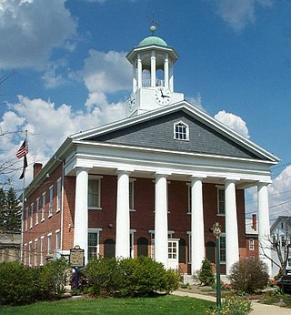
Mercersburg is a borough in Franklin County, Pennsylvania, United States. The borough is 72 miles (116 km) southwest of Harrisburg, the state capital.
Mont Alto is a borough in Franklin County, Pennsylvania, United States. The population was 1,580 at the 2020 census.
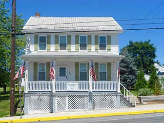
Orrstown is a borough in Franklin County, Pennsylvania, United States. The population was 214 at the 2020 census.
Peters Township is a township in Franklin County, Pennsylvania, United States. The population was 4,462 at the 2020 census.
Wayne Heights is a census-designated place (CDP) in Franklin County, Pennsylvania, United States. The population was 2,606 at the 2020 census.
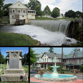
Orbisonia is a borough in Huntingdon County, Pennsylvania, United States. The population was 428 at the 2010 census.
Shade Gap is a borough in Huntingdon County, Pennsylvania, United States. The population was 105 at the 2010 census.
Quarryville is a borough in Lancaster County, Pennsylvania, United States. The population was 2,852 at the 2020 census, an increase over the figure of 2,576 tabulated in 2010.
Addison is a borough in Somerset County, Pennsylvania, United States. It is part of the Johnstown, Pennsylvania, Metropolitan Statistical Area. The population was 165 at the 2020 census.