Warren, Pennsylvania

Last updated

Warren, Pennsylvania
Warren Municipal Building Jul 12.jpg
Warren Municipal Building in Warren in July 2012
Flag of Warren, Pennsylvania.png
Seal of Warren, Pennsylvania.png
Etymology: General Joseph Warren
Motto: 
"On the Banks of the Allegheny"
Warren County Pennsylvania Incorporated and Unincorporated areas Warren Highlighted.svg
Location of Warren in Warren County, Pennsylvania (left) and of Warren County in Pennsylvania (right)
USA Pennsylvania location map.svg
Red pog.svg
Warren, Pennsylvania
Location of Warren in Pennsylvania
Coordinates: 41°50′39″N79°8′33″W / 41.84417°N 79.14250°W / 41.84417; -79.14250
Country United States
State Pennsylvania
County Warren
Founded1795
Government
  MayorDavid Wortman
Area
[1]
  Total3.09 sq mi (8.00 km2)
  Land2.91 sq mi (7.54 km2)
  Water0.18 sq mi (0.46 km2)
Elevation
1,210 ft (370 m)
Population
 (2010)
  Total9,710
  Estimate 
(2019) [2]
9,049
  Density3,108.55/sq mi (1,200.27/km2)
Time zone UTC-5 (EST)
  Summer (DST) UTC-4 (EDT)
ZIP Code
16365
Area code 814
FIPS code 42-81000
Website www.cityofwarrenpa.org

Warren is a city in and the county seat of Warren County, Pennsylvania, United States, located along the Allegheny River. [3] The population was 9,404 at the 2020 census. [4] It is home to the headquarters of the Allegheny National Forest and the Cornplanter State Forest. It is also the headquarters for the Chief Cornplanter Council, the oldest continuously chartered Boy Scouts of America Council, and the catalog company Blair. Warren is the principal city of the Warren micropolitan area.

Contents

History

United Refining in Warren United Refining.jpg
United Refining in Warren

Warren was initially inhabited by Native Americans of the Seneca nation. French explorers had longstanding claims to the area which they acted to secure in an unambiguous fashion with a military-Amerindian expedition in 1749 that buried a succession of plaques claiming the territory as France's in response to the formation of the colonial Ohio Company and the first of these was buried in Warren [5] but ultimately control was transferred to the British after the French and Indian War.

After the Revolutionary War, General William Irvine and Andrew Ellicott were sent to the area to lay out a town in 1795. It was named after Major General Joseph Warren. [6]

The first permanent structure in Warren, a storehouse built by the Holland Land Company, was completed in 1796. Daniel McQuay of Ireland was the first permanent inhabitant of European descent.

Lumber was the main industry from 18101840, as the abundance of wood and access to water made it profitable to float lumber down the Allegheny River to Pittsburgh.

David Beaty discovered oil in Warren in 1875 while drilling for natural gas in his wife's flower garden. Oil came to dominate the city's economy. Many of the town's large Victorian homes were built with revenue generated by the local oil and timber industries. [7]

Pittsburgh Des Moines, which was formerly located in Warren, manufacturered the Gateway Arch in St. Louis. [8] [9] Pittsburgh-Des Moines (PDM) also made railroad car tanks, storage tanks and other plate work. Several miniature replicas are located within the county, including one at the new visitors center on Routes US 6 and US 62 [9] next to the Pennsylvania State Police barracks.

Warren has struggled through hard economic times and a steady decline in population, which peaked at nearly 15,000 in 1940. The city is attempting to bounce back with the Impact Warren project, a riverfront development project in downtown Warren. The completed project will include new townhouses and senior citizen housing, retail and commercial development, a parking garage, convention center and bus depot. [10]

Major employers include Walmart, the United Refining Company (gas supplier for Kwik Fill and Red Apple Food Mart gas stations), Allegheny National Forest, Northwest Bank, Whirley-Drinkworks, Superior Tire and Rubber Corp, Pennsylvania General Energy, Betts Industries, Inc, Blair Corporation, Sheetz, and Interlectric.

The Warren Historic District, A.J. Hazeltine House, John P. Jefferson House, Struthers Library Building, Warren Armory, Warren County Courthouse, Wetmore House, Guy Irvine House. and Woman's Club of Warren are listed on the National Register of Historic Places. [11]

Geography

Warren is located at the confluence of the Allegheny River and the Conewango Creek. Conewango Creek flows between New York state and Warren. Allegheny Reservoir and Kinzua Dam are nearby.

According to the U.S. Census Bureau, Warren has a total area of 3.1 square miles (8.0 km2), 2.9 square miles (7.5 km2) of which is land and 0.2 square miles (0.52 km2) (6.11%) of which is water.

The Allegheny River from the Kinzua Dam to the City of Warren has been designated a "Recreational Waterway" by the United States Congress.

Climate

Climate data for Warren, Pennsylvania (1991–2020 normals, extremes 1896–present)
MonthJanFebMarAprMayJunJulAugSepOctNovDecYear
Record high °F (°C)74
(23)
74
(23)
83
(28)
92
(33)
95
(35)
98
(37)
102
(39)
100
(38)
100
(38)
90
(32)
84
(29)
74
(23)
102
(39)
Mean daily maximum °F (°C)32.6
(0.3)
35.2
(1.8)
44.3
(6.8)
58.3
(14.6)
69.8
(21.0)
77.4
(25.2)
81.3
(27.4)
80.4
(26.9)
74.0
(23.3)
60.8
(16.0)
47.9
(8.8)
37.2
(2.9)
58.3
(14.6)
Daily mean °F (°C)25.2
(−3.8)
26.5
(−3.1)
34.2
(1.2)
46.4
(8.0)
57.5
(14.2)
66.0
(18.9)
70.0
(21.1)
69.0
(20.6)
62.7
(17.1)
50.9
(10.5)
39.9
(4.4)
30.7
(−0.7)
48.2
(9.0)
Mean daily minimum °F (°C)17.8
(−7.9)
17.7
(−7.9)
24.2
(−4.3)
34.4
(1.3)
45.2
(7.3)
54.5
(12.5)
58.7
(14.8)
57.7
(14.3)
51.5
(10.8)
40.9
(4.9)
32.0
(0.0)
24.3
(−4.3)
38.2
(3.4)
Record low °F (°C)−26
(−32)
−34
(−37)
−24
(−31)
0
(−18)
20
(−7)
29
(−2)
36
(2)
35
(2)
26
(−3)
14
(−10)
1
(−17)
−22
(−30)
−34
(−37)
Average precipitation inches (mm)3.64
(92)
2.77
(70)
3.26
(83)
4.13
(105)
4.29
(109)
4.66
(118)
4.76
(121)
4.07
(103)
3.95
(100)
4.02
(102)
3.62
(92)
3.81
(97)
46.98
(1,193)
Average snowfall inches (cm)18.2
(46)
14.9
(38)
10.0
(25)
2.4
(6.1)
0.0
(0.0)
0.0
(0.0)
0.0
(0.0)
0.0
(0.0)
0.0
(0.0)
0.1
(0.25)
7.5
(19)
18.5
(47)
71.6
(182)
Average precipitation days (≥ 0.01 in)19.114.514.615.114.113.713.011.511.515.015.317.7175.1
Average snowy days (≥ 0.1 in)11.08.65.51.40.00.00.00.00.00.23.58.138.3
Source: NOAA [12] [13]

Demographics

Historical population
CensusPop.Note
1840 737
1850 1,01337.4%
1860 1,73871.6%
1870 2,01415.9%
1880 2,81039.5%
1890 4,33254.2%
1900 8,04385.7%
1910 11,08037.8%
1920 14,27228.8%
1930 14,8634.1%
1940 14,8910.2%
1950 14,849−0.3%
1960 14,505−2.3%
1970 12,998−10.4%
1980 12,146−6.6%
1990 11,122−8.4%
2000 10,259−7.8%
2010 9,710−5.4%
2019 (est.)9,049 [2] −6.8%
Sources: [14] [15] [16]

As of 2000 census, [16] there were 10,259 people, 4,565 households, and 2,606 families residing in the city. The population density was 3,508.3 inhabitants per square mile (1,354.6/km2). There were 5,046 housing units at an average density of 1,725.6 per square mile (666.3/km2). The racial makeup of the city was 98.53% White, 0.20% African American, 0.20% Native American, 0.36% Asian, 0.02% Pacific Islander, 0.13% from other races, and 0.56% from two or more races. Hispanic or Latino of any race were 0.39% of the population.

There were 4,566 households, out of which 27.2% had children under the age of 18 living with them, 43.0% were married couples living together, 10.8% had a female householder with no husband present, and 42.9% were non-families. 37.6% of all households were made up of individuals, and 16.4% had someone living alone who was 65 years of age or older. The average household size was 2.17 and the average family size was 2.87.

In the city, the population was spread out, with 23.1% under the age of 18, 7.0% from 18 to 24, 28.4% from 25 to 44, 23.4% from 45 to 64, and 18.1% who were 65 years of age or older. The median age was 39 years. For every 100 females, there were 88.5 males. For every 100 females age 18 and over, there were 83.9 males.

The median income for a household in the city was $32,384, and the median income for a family was $41,986. Males had a median income of $32,049 versus $22,969 for females. The per capita income for the city was $18,272. About 8.0% of families and 10.7% of the population were below the poverty line, including 11.5% of those under age 18 and 6.0% of those age 65 or over.

Sports

Warren hosted minor league baseball in three different leagues. The 1895 "Warren" team first played minor league baseball as members of the Iron and Oil League. [17] Between 1908 and 1916, Warren hosted the Warren Blues (1908), Warren Bingoes (1914–1915) and Warren Warriors (1916) teams, who all played as members of the Class D level Interstate League. [18] [19]

In 1940 and 1941, the Warren Redskins and Warren Buckeyes played in the Class D level Pennsylvania State Association. [18] [19] The team was a minor league affiliate of the Cleveland Indians in 1940. [20] The Warren teams played home minor league games at Russell Park. [21]

Education

For public K-12 education, the Warren County School District provides four elementary schools (Eisenhower, Sheffield Area, Warren Area, and Youngsville), one middle school (Beaty-Warren), three middle-high schools (Eisenhower, Sheffield Area, and Youngsville), and one high school (Warren Area).

Northern Pennsylvania Regional College (or NPRC) is an open-admissions college established in 2017 and, as of May 28, 2019, is authorized by the Pennsylvania Department of Education to grant degrees and certificates in the Commonwealth of Pennsylvania. [22]

The Warren County Career Center is an area vocational-technical school serving only the students in the Warren County School District. The Career Center provides training in multiple vocational fields to students in grades 10 through 12.

Notable people

See also

Related Research Articles

<span class="mw-page-title-main">Allegheny River</span> River in Pennsylvania and New York, United States

The Allegheny River is a 325-mile-long (523 km) headwater stream of the Ohio River that is located in western Pennsylvania and New York in the United States. It runs from its headwaters just below the middle of Pennsylvania's northern border, northwesterly into New York, then in a zigzag southwesterly across the border and through Western Pennsylvania to join the Monongahela River at the Forks of the Ohio at Point State Park in Downtown Pittsburgh, Pennsylvania.

<span class="mw-page-title-main">Warren County, Pennsylvania</span> County in Pennsylvania, United States

Warren County is a county in the Commonwealth of Pennsylvania. As of the 2020 census, the population was 38,587. Its county seat is Warren. The county was established in 1800 from parts of Allegheny and Lycoming counties; attached to Crawford County until 1805 and then to Venango County until Warren was formally established in 1819.

<span class="mw-page-title-main">Venango County, Pennsylvania</span> County in Pennsylvania, United States

Venango County is a county in the Commonwealth of Pennsylvania. As of the 2020 census, the population was 50,454. Its county seat is Franklin. The county was created in 1800 and later organized in 1805. The county is part of the Northwest Pennsylvania region of the state.

Coldspring is a town in Cattaraugus County, New York, United States. As of the 2020 census it had a population of 661. It is located in the southwest part of the county, west of the city of Salamanca.

South Valley is a town in Cattaraugus County, New York, United States. The population was 250 at the 2020 census. The name is derived from the town's geographical attributes.

<span class="mw-page-title-main">Carroll, New York</span> Town in New York, United States

Carroll is a town in Chautauqua County, New York, United States. The population was 3,456 at the 2020 census. The town is named after Charles Carroll, a signer of the Declaration of Independence.

<span class="mw-page-title-main">Kiantone, New York</span> Town in New York, United States

Kiantone is a town in Chautauqua County, New York, United States. As of the 2020 census, the town had a population of 1,388. The town is immediately south of Jamestown and is at the south border of the county.

<span class="mw-page-title-main">Hydetown, Pennsylvania</span> Borough in Pennsylvania, United States

Hydetown is a borough in Crawford County, Pennsylvania, United States. The population was 526 at the 2020 census, up from 526 at the 2010 census, down from 605 in 2000. It was established in 1862.

<span class="mw-page-title-main">Oil Creek Township, Crawford County, Pennsylvania</span> Township of Titusville Pennsylvania in the United States

Oil Creek Township is a township in Crawford County, Pennsylvania, United States. The population was 1,702 at the 2020 census, a decrease from 1,877 at the 2010 census.

<span class="mw-page-title-main">Rome Township, Crawford County, Pennsylvania</span> Township in Pennsylvania, United States

Rome Township is a township in Crawford County, Pennsylvania, United States. The population was 1,993 at the 2020 census, up from 1,840 at the 2010 census.

<span class="mw-page-title-main">Townville, Pennsylvania</span> Borough in Pennsylvania, United States

Townville is a borough in Crawford County, Pennsylvania, United States. The population was 326 at the 2020 census, up from 323 at the 2010 census.

<span class="mw-page-title-main">Tionesta Township, Forest County, Pennsylvania</span> Township in Pennsylvania, United States

Tionesta Township is a township in Forest County, Pennsylvania, United States. The population was 670 at the time of the 2020 census, up from the total of 729 that was documented by the 2010, up from 610 at the 2000 census.

<span class="mw-page-title-main">Cornplanter Township, Pennsylvania</span> Township in Pennsylvania, United States

Cornplanter Township is a township in Venango County, Pennsylvania, United States. The population was 2,317 at the 2020 census, a decrease from 2,487 at the 2010 and 2,687 at the 2000 census.

<span class="mw-page-title-main">Oil City, Pennsylvania</span> City in Pennsylvania, United States

Oil City is the largest city in Venango County, Pennsylvania, United States. Known for its prominence in the initial exploration and development of the petroleum industry, it is located at a bend in the Allegheny River at the mouth of Oil Creek. The population was 9,608 at the 2020 census, and it is the principal city of the Oil City micropolitan area.

<span class="mw-page-title-main">Brokenstraw Township, Warren County, Pennsylvania</span> Township in Pennsylvania, United States

Brokenstraw Township is a township in Warren County, Pennsylvania, United States. It was formed in 1800. The population was 1,730 at the 2020 census, down from 1,884 at the 2010 census.

<span class="mw-page-title-main">Eldred Township, Warren County, Pennsylvania</span> Township in Pennsylvania, United States

Eldred Township is a township in Warren County, Pennsylvania, United States. The population was 587 at the 2020 census, down from 650 at the 2010 census.

<span class="mw-page-title-main">Mead Township, Pennsylvania</span> Township in Pennsylvania, United States

Mead Township is a township in Warren County, Pennsylvania, United States. The population was 1,300 at the 2020 census, down from 1,386 at the 2010 census and 1,555 at the 2000 census.

<span class="mw-page-title-main">Southwest Township, Warren County, Pennsylvania</span> Township in Pennsylvania, United States

Southwest Township is a township in Warren County, Pennsylvania, United States. The population was 426 at the 2020 census, down from 527 at the 2010 census. 561 at the 2000 census.

<span class="mw-page-title-main">Randolph (CDP), New York</span> Hamlet and CDP in New York, United States

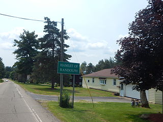
Randolph is a hamlet, census-designated place (CDP) and former village in Cattaraugus County, New York, United States. It is located within the town of Randolph. The population of the village was 1,286 at the 2010 census, out of 2,602 in the town as a whole. Randolph borders the community of East Randolph.

<span class="mw-page-title-main">Kinzua Township, Warren County, Pennsylvania</span> Township in Pennsylvania, United States

Kinzua Township was a township in Warren County, Pennsylvania in the United States. The township was merged in 1963 into Mead Township.

References

  1. "2019 U.S. Gazetteer Files". United States Census Bureau. Retrieved July 28, 2020.
  2. 1 2 "Population and Housing Unit Estimates". United States Census Bureau. May 24, 2020. Retrieved May 27, 2020.
  3. "Find a County". National Association of Counties. Retrieved June 7, 2011.
  4. "U.S. Census Bureau QuickFacts: Warren city, Pennsylvania".
  5. Commissioners: Thomas Lynch Montgomery, Henry Melchior Muhlenberg Richards, John M. Buckalew, George Dallas Albert, Sheldon Reynolds, Jay Gilfillan Weiser, report compiled by George Dallas Albert (1916). The frontier forts of western Pennsylvania. W.S. Ray, state printer. Report By the Commission to Locate the Site of the Frontier Forts of Pennsylvania. p. 4 (Introduction). Retrieved November 29, 2010. Thereupon to counteract the designs of the English, the Governor-General of Canada, the Marquis de la Galissoniere, sent Celoron in 1749 down the Allegheny and Ohio riversm to take possession of the country in the name of the King of France. His command consisted of 215 French and Canadian soldiers and 55 Indians of various tribes. ... omitted ... Provided with a number of leaden plates, the left... omitted ... by means of Chatauqua creek, a portage, Chautauqua Lake and Conewango creek, they came on the 29th, to the Allegheny river, near the point now occupied by the town of Warren, in Warren County, Pa. The first of the leaden plates was buried at this point. (Q.E.D.){{cite book}}: CS1 maint: multiple names: authors list (link)
  6. "Profile for Warren, Pennsylvania". ePodunk . Retrieved May 15, 2010.
  7. Waples, David A. (2012). The Natural Gas Industry in Appalachia: A History from the First Discovery to the Tapping of the Marcellus Shale. pp. 20–21. ISBN 9780786470006.
  8. "Pennsylvania boilermakers want you to know that they helped build the Arch, too". St. Louis Public Radio. October 23, 2015. Retrieved April 11, 2021.
  9. 1 2 "New 'Baby Arch' in Pennsylvania honors boilermakers who built Gateway Arch". St. Louis Public Radio. July 4, 2017. Retrieved April 11, 2021.
  10. Source?: September 2022
  11. "National Register Information System". National Register of Historic Places . National Park Service. July 9, 2010.
  12. "NowData – NOAA Online Weather Data". National Oceanic and Atmospheric Administration. Retrieved August 7, 2021.
  13. "Station: Warren, PA". U.S. Climate Normals 2020: U.S. Monthly Climate Normals (1991-2020). National Oceanic and Atmospheric Administration. Retrieved August 7, 2021.
  14. "Number of Inhabitants: Pennsylvania" (PDF). 18th Census of the United States. U.S. Census Bureau. Retrieved November 22, 2013.
  15. "Pennsylvania: Population and Housing Unit Counts" (PDF). U.S. Census Bureau. Retrieved November 22, 2013.
  16. 1 2 "U.S. Census website". United States Census Bureau . Retrieved January 31, 2008.
  17. "1895 Warren Statistics". Baseball-Reference.com.
  18. 1 2 "Warren, Pennsylvania Encyclopedia". Baseball-Reference.com.
  19. 1 2 Johnson, Lloyd; Wolff, Miles, eds. (2007). The Encyclopedia of Minor League Baseball (Third ed.). Baseball America. ISBN   978-1932391176.
  20. "1940 Warren Redskins Statistics". Baseball-Reference.com.
  21. "Russell Park in Warren, PA minor league baseball history and teams on StatsCrew.com". www.statscrew.com.
  22. "Our Story". Northern Pennsylvania Regional College. Retrieved January 4, 2023.