Tredyffrin Township, Pennsylvania

Last updated

Tredyffrin Township
Anthony Wayne statue.jpeg
Chester County Pennsylvania incorporated and unincorporated areas Tredyffrin highlighted.svg
Location in Chester County and the state of Pennsylvania.
Pennsylvania in United States (US48).svg
Location of Pennsylvania in the United States
Coordinates: 40°03′48″N75°22′14″W / 40.06333°N 75.37056°W / 40.06333; -75.37056
CountryUnited States
StatePennsylvania
County Chester
Founded1707
Area
[1]
  Total19.85 sq mi (51.41 km2)
  Land19.77 sq mi (51.19 km2)
  Water0.09 sq mi (0.22 km2)
Elevation
397 ft (121 m)
Population
 (2010)
  Total29,332
  Estimate 
(2016) [2]
29,423
  Density1,488.57/sq mi (574.75/km2)
Time zone UTC-5 (EST)
  Summer (DST) UTC-4 (EDT)
Area code 610
FIPS code 42-029-77344
Website www.tredyffrin.org

Tredyffrin Township ( /trɪˈdɪfrɪn/ Welsh: [trɛˈdɘfrɪn] ) is a township located in eastern Chester County, Pennsylvania, United States. The population was 29,332 at the 2010 census.

Contents

Settled in the late 17th century, Tredyffrin is bounded by Delaware and Montgomery counties. It includes on its northern boundary a small part of Valley Forge National Historical Park, where George Washington encamped during the American War of Independence. Tredyffrin and the entire Great Valley region also have many limestone deposits. Tredyffrin is the most populous township in Chester County.

Unincorporated communities within Tredyffrin Township include Chesterbrook, Strafford, a portion of Paoli, and a portion of Wayne, Howellville (the intersection of Swedesford and Howellville Roads) and East Howellville (along Howellville Road, west of the intersection of Howellville Road and the border between Tredyffrin and Easttown Townships). Tredyffrin is bordered by Easttown, East Whiteland, Willistown, Charlestown, Upper Merion, Radnor and Schuylkill townships.

History

On March 13, 1684, William Penn decided to set aside a portion of Pennsylvania for the Welsh to settle in. This area, known as the "Welsh Tract", was surveyed in 1684 and included several modern-day townships, including Tredyffrin. Although the Welsh Tract was originally meant to be a self-ruling municipality, it was divided between Chester County and Philadelphia when that county was created in 1685, and the Welsh subsequently submitted to the authority of Chester County. In 1707, Tredyffrin was incorporated as a township. This name comes from the Welsh tre(f) , which means "town", joined to dyffryn , which means "wide, cultivated valley". Tredyffrin was quick to develop into a thriving township. In 1710, the first mill in Tredyffrin was started by Thomas Jerman on what is now North Valley Road. Swedesford Road, one of the first roads in the township, was created by 1718.

As the population of the township grew, with 30 resident landowners in 1722 and 83 in 1774, churches sprung up to meet the demand by religious residents. In 1710, the Baptist minister Hugh Davis moved to the Great Valley from Britain and, there being several Baptist families in this area, the Baptist Church in the Great Valley was formed on April 22, 1711. The church originally met in Radnor. However, there were enough members of this Baptist church that by 1722, a log building was erected in Tredyffrin to serve the congregation.

As Tredyffrin includes part of Valley Forge National Historical Park, there are many Revolutionary War-related sites in the township, especially the park and houses where various generals were quartered.

Development in the township was sparked in the 19th century by construction and advertisement of the "Main Line" railroad service, which terminated in Paoli, which straddles the western border of the township.

Tredyffrin-Easttown school district was unusual for the area in being racially integrated during the early part of the century. [3] In 1932, the district planned to segregate after building a new school, and African Americans in the township boycotted the school system for two years in protest (the "School Fight"). In 1934 a negotiated settlement was reached whereby the schools remained integrated, and helped kill school segregation in Pennsylvania.

During the Cold War, a Nike anti-aircraft missile site was active in the township. It was located off Le Boutillier Road, near Swedesford Road.

Historic buildings

County Bridge No. 171, Cramond, Cressbrook Farm, Federal Barn, Great Valley Mill, Greenwood Farm, David Havard House, Lafayette's Quarters, Maj. Gen. Lord Stirling Quarters, Mount Zion A.M.E. Church, Strafford Railroad Station, Valley Forge National Historical Park, Joseph Walker House, Van Leer Cabin, and Wetherby–Hampton–Snyder–Wilson–Erdman Log House are listed on the National Register of Historic Places. In addition, the Wharton Esherick Museum is listed as a National Historic Landmark; it was built starting in 1926. [4]

Other notable buildings are:

Geography

According to the U.S. Census Bureau, the township has a total area of 19.9 square miles (52 km2), of which 19.8 square miles (51 km2) is land and 0.04 square miles (0.10 km2), or 0.15%, is water.

Tredyffrin's climate borders upon hot-summer humid continental (Dfa) and humid subtropical (Cfa). The hardiness zone is 7a as in almost all of Chester County.

Transportation

Pennsylvania Turnpike/I-76 eastbound in Tredyffrin Township 2022-09-18 13 57 22 View east along Interstate 76 (Pennsylvania Turnpike Philadelphia Extension) from the overpass for the ramps to Pennsylvania State Route 29 (Charlestown Road) in Tredyffrin Township, Chester County, Pennsylvania.jpg
Pennsylvania Turnpike/I-76 eastbound in Tredyffrin Township

As of 2018, there were 150.13 miles (241.61 km) of public roads in Tredyffrin Township, of which 6.30 miles (10.14 km) were maintained by the Pennsylvania Turnpike Commission (PTC), 36.94 miles (59.45 km) were maintained by the Pennsylvania Department of Transportation (PennDOT) and 106.89 miles (172.02 km) were maintained by the township. [6]

The Pennsylvania Turnpike (I-76) is the most prominent road serving Tredyffrin Township. It follows a southwest-northeast alignment across the northwestern portion of the township. U.S. Route 202 follows a similar alignment across the center of the township. U.S. Route 422 begins at US 202 in the northeastern corner of the township and follows the County Line Expressway northwestward. U.S. Route 30 follows Lancaster Avenue along an east-west alignment through the southern section of the township. Finally, Pennsylvania Route 252 follows Leopard Road, Bear Hill Road, Swedesford Road, Valley Forge Road and Valley Creek Road along a north-south alignment through the middle of the township.

Demographics

Historical population
CensusPop.Note
1930 5,458
1940 6,26014.7%
1950 7,83625.2%
1960 16,004104.2%
1970 23,40446.2%
1980 23,019−1.6%
1990 28,02821.8%
2000 29,0623.7%
2010 29,3320.9%
2020 31,9278.8%
[7] [8]

At the 2010 census, the township was 83.3% non-Hispanic White, 3.3% Black or African American, 0.1% Native American, 9.8% Asian, and 1.4% were two or more races. 2.2% of the population were of Hispanic or Latino ancestry. [9]

As of the 2000 United States census, there were 29,062 people, 12,223 households, and 7,834 families residing in the township. The population density was 1,464.9 inhabitants per square mile (565.6/km2). [10] There were 12,551 housing units at an average density of 632.6 per square mile (244.2/km2). The racial makeup of the township was 90.88% White, 2.84% African American, 0.11% Native American, 5.12% Asian, 0.01% Pacific Islander, 0.29% from other races, and 0.74% from two or more races. Hispanic or Latino of any race were 1.20% of the population.

There were 12,223 households, out of which 29.0% had children under the age of 18 living with them, 55.9% were married couples living together, 6.2% had a female householder with no husband present, and 35.9% were non-families. 30.1% of all households were made up of individuals, and 9.1% had someone living alone who was 65 years of age or older. The average household size was 2.36 and the average family size was 2.99.

In the township the population was spread out, with 23.3% under the age of 18, 4.7% from 18 to 24, 30.1% from 25 to 44, 27.2% from 45 to 64, and 14.7% who were 65 years of age or older. The median age was 40 years. For every 100 females there were 89.9 males. For every 100 females age 18 and over, there were 86.7 males.

The median income for a household in the township was $82,258, and the median income for a family was $105,183 (these figures had risen to $90,915 and $121,809 respectively as of a 2007 estimate). [11] Males had a median income of $76,393 versus $46,124 for females. The per capita income for the township was $47,584. About 2.2% of families and 3.7% of the population were below the poverty line, including 4.6% of those under age 18 and 2.8% of those age 65 or over.

Government

Tredyffrin is governed by a seven-member Board of Supervisors. Four members are elected from the township at-large, while three members are elected from specific districts, though all supervisors are treated equally once on the Board.

as of November 5,2021: [12]

DistrictSupervisorPartyTerm ends
At-LargeMark Freed Democratic 2023
Sharon Humble Democratic 2023
Matt Holt Democratic 2025
Murph Wysocki Democratic 2025
Eastern DistrictJulie Gosse Democratic 2023
Middle DistrictDavid Miller Democratic 2025
Western DistrictKasi Bhaskar Democratic 2023

Politics

Party registration as of July 2010 were 45% Republican, 39% Democratic, and 16% Independent and third parties. In the 2008 presidential election, Tredyffrin voters gave 58% of its votes to Democratic candidate Barack Obama over John McCain, a significant change from previous elections. Mitt Romney vastly improved upon McCain's performance, but still fell short as Obama carried the township with 52% of the vote in the 2012 presidential election.

Party registration as of December 2019 stood at 43% Democratic, 39% Republican, 18% Independent and third parties.

Geology

The rocks of Tredyffrin were laid down in the upper Paleozoic, meaning that they are primarily metamorphic. Limestone is often at the surface in the Great Valley, so many limestone kilns were created in the 18th century. Mine owner William Rennyson sold the fizzy water from his Howellville limestone quarry as "Tredyffrin Water" around 1900. [13] The northern edge of the township is a ridge of quartzite and sandstone (the Cambrian Chickies Formation) including Valley Forge Mountain (or Mount Misery), which was mined for quartz in the 18th century through the mid-19th century.

Education

Primary and secondary schools

Conestoga High School Conestoga High School.jpg
Conestoga High School

Tredyffrin Township lies within the Tredyffrin/Easttown School District. [14] Students residing within township boundaries attend Hillside Elementary School, New Eagle Elementary School, and Valley Forge Elementary School for grades K–4. Tredyffrin/Easttown Middle School and Valley Forge Middle School serve students in grades 5–8, and Conestoga High School serves students in grades 9–12. [15]

Private schools in Tredyffrin Township include:

Public libraries

Tredyffrin Township Libraries operates Tredyffrin Public Library and Paoli Library. [16]

The Tredyffrin Library, with 18,000 square feet (1,700 m2) of space as of 1977, is located in the Strafford community. [17] The architectural firm Mitchell/Giurgola developed the Tredyffrin Library. It has an amphitheater that is focused on a park in a southward direction. [18] The library has a single large reading room. [17] The library building has a larger two-story end, while the other end has only one story at the upper level. [19] Offices at the main level are in a separate element of the structure from the main reading room, and this structure juts out from the flue. Architectural Record said that this "allows direct access to the reading room from the public entrance." [17] In 1990 a new children's library was created on the lower level of the building in previously unfinished space. [20]

As the community continued to grow and change, plans were finalized in 2004 to renovate and expand Tredyffrin Library. In September 2007, the library broke ground for a $6 million renovation and expansion. On January 31, 2009, the entire expanded building was open to the public for the first time. [20]

Architectural Record stated that Tredyffrin Library and the library built in Condon Hall of the University of Washington School of Law, which was also designed by Mitchell/Giurgola, have common underlying concepts. According to the publication, the shared concepts were "unusual sensitivity in using natural light to best advantage while warding off the sun," a "quickly apparent organization of functions," and being "responsive to the varying situations in which it is built." [18]

Related Research Articles

<span class="mw-page-title-main">Chester County, Pennsylvania</span> County in Pennsylvania, United States

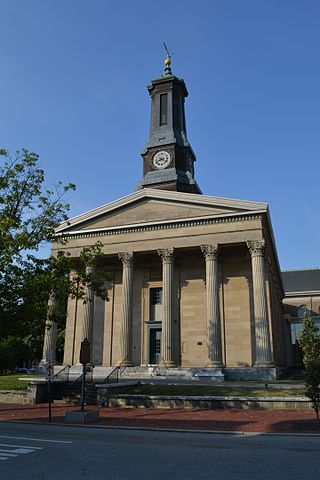
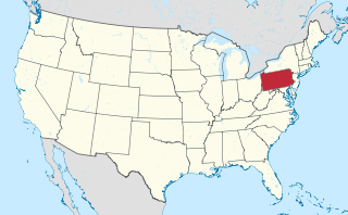
Chester County, colloquially referred to as Chesco, is a county in the Commonwealth of Pennsylvania. It is located in the Delaware Valley region, located in the southeastern part of the state. As of the 2020 census, the population was 545,823(As of 2022), increasing by 7.1% from 498,886 in 2010. The county seat is the Borough of West Chester. The most populous of its 73 municipalities is Tredyffrin Township. The most populous boroughs are West Chester and Phoenixville. Coatesville is the only municipality in the County organized under the City form of government, a technical rather than demographic distinction. Chester County was one of the three original Pennsylvania counties created by William Penn in 1682. It was named for Chester, England. The county is part of the Southeast Pennsylvania region of the state.

<span class="mw-page-title-main">Charlestown Township, Pennsylvania</span> Township in Pennsylvania, United States

Charlestown Township is a township in Chester County, Pennsylvania, United States. The population was 6,003 at the 2020 census.

<span class="mw-page-title-main">Chesterbrook, Pennsylvania</span> Census-designated place in Pennsylvania, United States

Chesterbrook is a census-designated place (CDP) in Chester County, Pennsylvania, United States. It is located within the Philadelphia metropolitan area and just south of Valley Forge National Historical Park. The population was 4,589 at the 2010 census.

<span class="mw-page-title-main">East Goshen Township, Pennsylvania</span> Township in Pennsylvania, United States

East Goshen Township is a township in Chester County, Pennsylvania, United States. The population was 18,026 at the 2010 census.

<span class="mw-page-title-main">East Whiteland Township, Pennsylvania</span> Township in Pennsylvania, United States

East Whiteland Township is a township in Chester County, Pennsylvania, United States. The population was 13,913 at the 2020 Census. Mailing addresses associated with East Whiteland include Malvern, Frazer, and a small area of Exton.

<span class="mw-page-title-main">Easttown Township, Pennsylvania</span> Township in Pennsylvania, United States

Easttown Township is a township in Chester County, Pennsylvania, United States. The population was 10,984 at the 2020 census. The township, which lies in the western half of Philadelphia's Main Line suburbs, is comprised predominantly of parts of two unincorporated areas: Devon and Berwyn. A small portion of the township has a Paoli address.

<span class="mw-page-title-main">Malvern, Pennsylvania</span> Borough in Pennsylvania, United States

Malvern is a borough in Chester County, Pennsylvania, United States. Malvern is the terminus of the Main Line, a series of highly affluent Philadelphia suburbs located along the railroad tracks of the Pennsylvania Railroad. It is 19.4 miles (31.2 km) west of Philadelphia. The population was 3,419 at the 2020 census.

<span class="mw-page-title-main">Paoli, Pennsylvania</span> Census-designated place in Pennsylvania, United States

Paoli is a census-designated place (CDP) in Chester County near Philadelphia, Pennsylvania, United States. It is situated in portions of two townships: Tredyffrin and Willistown. At the 2020 census, it had a total population of 6,002.

<span class="mw-page-title-main">Willistown Township, Pennsylvania</span> Township in Pennsylvania, United States

Willistown Township is a township in Chester County, Pennsylvania, United States. The population was 10,497 at the 2010 census. At the 1860 census, the population of Willistown was 1,521, and in 1980 it was 8,269.

<span class="mw-page-title-main">Radnor Township, Pennsylvania</span> Township with home rule in Pennsylvania, United States

Radnor Township, often called simply Radnor, is a first class township with home rule status in Delaware County, Pennsylvania, United States.

<span class="mw-page-title-main">Philadelphia Main Line</span> Collection of suburban communities in Pennsylvania, United States

The Philadelphia Main Line, known simply as the Main Line, is an informally delineated historical and social region of suburban Philadelphia, Pennsylvania. Lying along the former Pennsylvania Railroad's once prestigious Main Line, it runs northwest from Center City Philadelphia parallel to Lancaster Avenue, also known as U.S. Route 30.

<span class="mw-page-title-main">Berwyn, Pennsylvania</span> Census-designated place in Pennsylvania, United States

Berwyn is a census-designated place (CDP) in Chester County, Pennsylvania, United States. Berwyn is located in Tredyffrin and Easttown townships. The area is part of the Philadelphia Main Line suburbs.

<span class="mw-page-title-main">Devon, Pennsylvania</span> Census-designated place in Pennsylvania, United States

Devon is a census-designated place (CDP) located in Easttown township in Chester County, Pennsylvania, United States. The population was 1,515 at the 2010 census. The area is part of the Philadelphia Main Line suburbs.

<span class="mw-page-title-main">Wayne, Pennsylvania</span> Unincorporated community in Delaware County, Pennsylvania, United States

Wayne is an unincorporated community centered in Delaware County, Pennsylvania, United States, on the Main Line, a series of highly affluent Philadelphia suburbs located along the railroad tracks of the Pennsylvania Railroad and one of the wealthiest areas in the nation. While the center of Wayne is in Radnor Township, Wayne extends into both Tredyffrin Township in Chester County and Upper Merion Township in Montgomery County. The center of Wayne was designated the Downtown Wayne Historic District in 2012. Considering the large area served by the Wayne post office, the community may extend slightly into Easttown Township, Chester County, as well.

<span class="mw-page-title-main">Strafford station</span>

Strafford station is a commuter rail station located in the western suburbs of Philadelphia at Old Eagle School Road and Crestline Road, in Tredyffrin Township, and it is served by most Paoli/Thorndale Line trains.

<span class="mw-page-title-main">Tredyffrin/Easttown School District</span> Public school district in Chester County, Pennsylvania

Tredyffrin/Easttown School District is a school district based in Tredyffrin Township, Chester County, Pennsylvania.

<span class="mw-page-title-main">Strafford, Pennsylvania</span> Unincorporated community in Pennsylvania, United States

Strafford is an unincorporated community in the southeastern part of the U.S. state of Pennsylvania, located partly in Tredyffrin Township, Chester County, and partly in Radnor Township, Delaware County. It is served by its own stop on the SEPTA Paoli/Thorndale Line regional rail train. The SEPTA station at Strafford is one of the few buildings that survives from the 1876 Centennial Exposition at Philadelphia. It is also the site of the Strafford School, and the Old Eagle School. It is in the Eastern Standard time zone. Elevation is 440 feet.

<span class="mw-page-title-main">Pennsylvania Route 252</span> State highway in Pennsylvania, US

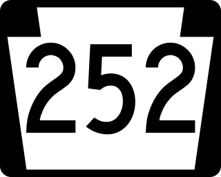
Pennsylvania Route 252 is a north–south state highway in the U.S. state of Pennsylvania that connects PA 320 in Nether Providence Township at its southern terminus to PA 23 in Valley Forge at its northern terminus. The route runs through the western suburbs of Philadelphia in Delaware, Chester, and Montgomery counties, including Nether Providence Township, the borough of Media, Upper Providence Township, Marple Township, Newtown Township, Easttown Township, Tredyffrin Township, and Upper Merion Township. The route intersects many roads including U.S. Route 1 north of Media, PA 3 in Newtown Square, US 30 in Paoli, and US 202 near Berwyn.

<span class="mw-page-title-main">U.S. Route 202 in Pennsylvania</span> US Highway in Pennsylvania

U.S. Route 202 is a US Highway running from New Castle, Delaware, northeast to Bangor, Maine. In the U.S. state of Pennsylvania, the route runs for 59 miles (95 km), from the Delaware state line in Bethel Township, Delaware County, to the New Hope–Lambertville Toll Bridge over the Delaware River in Solebury Township, where the route crosses into New Jersey. The highway runs through the western and northern suburbs of Philadelphia in the Delaware Valley metropolitan area, and serves as a toll-free bypass around the city, avoiding the busy traffic and congestion on Interstate 95 (I-95). It is signed north–south and follows a general southwest–northeast direction through the state.

<span class="mw-page-title-main">David Havard House</span> Historic house in Pennsylvania, United States

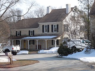
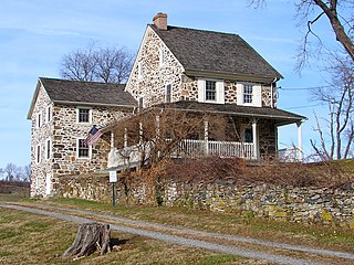
The David Havard House, also known as the Former Quarters of Lee and Bradford, is a historic home located near Valley Forge in Tredyffrin Township, Chester County, Pennsylvania. During the American Revolutionary War, it served as quarters for several of George Washington's senior officers.

References

  1. "2016 U.S. Gazetteer Files". United States Census Bureau. Retrieved August 13, 2017.
  2. "Population and Housing Unit Estimates" . Retrieved June 9, 2017.
  3. Bill Cosby and Main Line education Archived August 14, 2007, at the Wayback Machine
  4. "National Register Information System". National Register of Historic Places . National Park Service. July 9, 2010.
  5. Tredyffrin historic sites Archived November 29, 2010, at the Wayback Machine
  6. "Tredyffrin Township map" (PDF). PennDOT. Retrieved March 13, 2023.
  7. "DVRPC > Site Search". Archived from the original on April 9, 2019. Retrieved March 21, 2014.
  8. "Census 2020".
  9. https://web.archive.org/web/20110314234139/http://www.usatoday.com/news/nation/census/profile/pa
  10. "U.S. Census website". United States Census Bureau . Retrieved January 31, 2008.
  11. "Explore Census Data". data.census.gov. Retrieved November 5, 2021.
  12. "Votes Nearly Tallied In Tredyffrin Township Races". Tredyffrin-Easttown, PA Patch. November 4, 2021. Retrieved November 5, 2021.
  13. https://patch.com/pennsylvania/te/tredyffrin-water-was-known-medicinal-qualities-historical-society-says "'Tredyffrin Water' Was Known For Medicinal Qualities, Historical Society Says", Justin Heinze, Patch, August 4, 2016
  14. "Maps." Tredyffrin Township. Retrieved on October 9, 2018. See Zoning map
  15. "TESDmap2015.pdf." Tredyffrin/Easttown School District. Retrieved on October 9, 2018.
  16. Home page. Tredyffrin Township Libraries. Retrieved on September 8, 2009.
  17. 1 2 3 "Relating common solutions: two libraries by Mitchell/Giurgola." p. 95.
  18. 1 2 "Relating common solutions: two libraries by Mitchell/Giurgola." p. 93.
  19. "Relating common solutions: two libraries by Mitchell/Giurgola." p. 94.
  20. 1 2 http://www.tredyffrinlibraries.org/tredyffrin-public-library/history/ . Tredyffrin Township Libraries. Retrieved on December 14, 2018.

Sources