
Chester County, colloquially known as Chesco, is a county in the Commonwealth of Pennsylvania. It is located in the Delaware Valley region, located in the southeastern part of the state. As of the 2020 census, the population was 534,413, increasing by 7.1% from 498,886 in 2010. The county seat and most populated municipality is West Chester. Chester County was one of the three original Pennsylvania counties created by William Penn in 1682. It was named for Chester, England.

Pennsylvania House of Representatives District 160 includes parts of Chester County and Delaware County. It is currently represented by Republican Craig Williams.
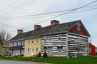
Wagontown is an unincorporated community in West Caln Township, Chester County, Pennsylvania, United States. Wagontown is located along Pennsylvania Route 340, 2.15 miles (3.46 km) north-northwest of Coatesville. Wagontown has a post office with ZIP code 19376. The Hibernia House, which is listed on the National Register of Historic Places, is located near Wagontown.
Russellville is an unincorporated community in Upper Oxford Township in Chester County, Pennsylvania, United States. Russellville is located at the intersection of state routes 10 and 896.

Chatham is an unincorporated community in London Grove Township in Chester County, Pennsylvania, United States. Chatham is located at the intersection of Pennsylvania Route 41 and Pennsylvania Route 841.
Springdell is an unincorporated community in West Marlborough Township in Chester County, Pennsylvania, United States. Springdell is located at the intersection of Pennsylvania Route 841 and Spring Dell Road.
Pocopson is an unincorporated community in Pocopson Township in Chester County, Pennsylvania, United States. Pocopson is located at the intersection of Pennsylvania Route 926 and Pocopson Road.
Devault is an unincorporated community in Charlestown Township in Chester County, Pennsylvania, United States. Devault is located at the intersection of Pennsylvania Route 29, Phoenixville Pike, and Charlestown Road.
Compass is an unincorporated community in West Caln Township in Chester County, Pennsylvania, United States. Compass is located at the intersection of Pennsylvania Route 10 and Pennsylvania Route 340.
Goshenville is an unincorporated community in East Goshen Township in Chester County, Pennsylvania, United States. Goshenville is located at the intersection of Pennsylvania Route 352 and Paoli Pike.
Lenape is an unincorporated community in Pocopson Township in Chester County, Pennsylvania, United States. Lenape is centered on the intersection of Pennsylvania Route 52 and Pocopson Road west of the Brandywine Creek.
Mendenhall is an unincorporated community in Kennett Township in Chester County, Pennsylvania, United States. Mendenhall is located at the intersection of Pennsylvania Route 52 and Hillendale Road.
Lewisville is an unincorporated community in Elk Township in Chester County, Pennsylvania, United States. Lewisville is located at the intersection of state routes 472 and 841, just north of the Maryland border.
Doe Run is an unincorporated community in West Marlborough Township in Chester County, Pennsylvania, United States. Doe Run is located at the intersection of Pennsylvania Route 82 and Pennsylvania Route 841.
Chesterville is an unincorporated community in Franklin Township in Chester County, Pennsylvania, United States. Chesterville is located at the intersection of Pennsylvania Route 841, Chesterville Road, and North Creek Road.
Kelton is an unincorporated community in Penn Township in Chester County, Pennsylvania, United States. Kelton is located at the intersection of Pennsylvania Route 796 and Kelton Road.
Brandamore is an unincorporated community in West Brandywine Township in Chester County, Pennsylvania, United States. Brandamore is located at the intersection of Hibernia Road and Brandamore Road north of Coatesville.
Sadsburyville is an unincorporated area in Sadsbury Township in Chester County, Pennsylvania, United States. Sadsburyville is located at the intersection of U.S. Route 30 Business and Old Wilmington Road about 4 miles west of Coatesville and about 3 miles northeast of Parkesburg.
Suplee is an unincorporated community in Honey Brook Township in Chester County, Pennsylvania, United States. Suplee is located along Suplee Road, east of Honey Brook.
Darlington Corners is an unincorporated community in Thronbury and Westtown townships in Chester County, Pennsylvania, United States. Darlington Corners is located at the intersection of U.S. Route 202/U.S. Route 322 and Pennsylvania Route 926 south of West Chester.

