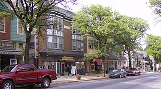
Strasburg is a borough in Lancaster County, Pennsylvania, United States. It developed as a linear village stretching approximately 2 miles (3 km) along the Great Conestoga Road, later known as the Strasburg Road. The population was 3,117 at the 2020 census.

Lenhartsville is a borough in Berks County, Pennsylvania, United States. The population was 165 at the 2010 census.

Shoemakersville is a borough in Berks County, Pennsylvania, United States. The population was 1,378 at the 2010 census, a decline from the figure of 2,124 tabulated in 2000.

Wernersville is a borough in Berks County, Pennsylvania, United States. The population was 2,494 at the 2010 census.
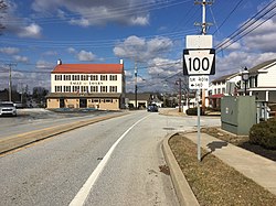
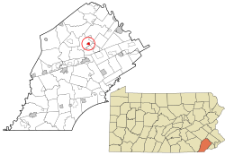
Womelsdorf is a borough in Berks County, Pennsylvania, United States. The population was 2,810 at the 2010 census. The main thoroughfares through Womelsdorf are High Street, which runs east–west, and Pennsylvania Route 419, which runs north–south. U.S. Route 422 runs along the northern edge of town.

Dublin is a borough in Bucks County, Pennsylvania, United States. The population was 2,158 at the 2010 census. Dublin is part of Pennridge School District.

Warrington Township is a township in Bucks County, Pennsylvania, United States. Warrington Township is a northern suburb of Philadelphia. The population was 25,639 at the 2020 census.

Boalsburg is an unincorporated community and census-designated place (CDP) in Harris Township, Centre County, Pennsylvania, United States. It is part of the State College, Pennsylvania Metropolitan Statistical Area. The population was 3,722 at the 2010 census. The village claims to be the birthplace of Memorial Day. However, that claim was brought into question by Bellware and Gardiner in their book, The Genesis of the Memorial Day Holiday in America, in 2014. In their book, Bellware and Gardiner point out that the Boalsburg story was first published in 1904, forty years after the fact with no indication that General Logan drew inspiration from any activities in Boalsburg and no evidence that it started the holiday.

Downingtown is a borough in Chester County, Pennsylvania, United States, 33 miles (53 km) west of Philadelphia. As of the 2020 census, it had a population of 7,898. Downingtown was settled by European colonists in the early 18th century and has a number of historic buildings and structures.
Kennett Square is a borough in Chester County, Pennsylvania, United States. As of the 2020 U.S. census, Kennett Square had a population of 5,943.

Parkesburg is a borough in Chester County, Pennsylvania, United States. The population was counted as 3,866 at the 2020 census. The ZIP code is 19365.

Upper Uwchlan Township is a township in Chester County, Pennsylvania, United States. The population was 11,227 at the 2010 census. The township included the community of Milford Mills before it was inundated by the creation of the Marsh Creek Dam in 1972.

Uwchlan Township is a township in Chester County, Pennsylvania, United States. The population was 19,161 at the 2020 census.
Hopwood is a census-designated place (CDP) in Fayette County, Pennsylvania, United States. The population was 2,090 at the 2010 census, up from 2,006 at the 2000 census. It is located in North Union and South Union townships. The village was named after John Hopwood.
South Union Township is a township in Fayette County, Pennsylvania, United States. The population was 10,895 at the 2020 census, an increase over the figure of 10,681 tabulated in 2010.

McConnellsburg is a borough in Fulton County, Pennsylvania, United States. The population was 1,150 at the 2020 census. It is the county seat of Fulton County.

Coopersburg is a borough in Lehigh County, Pennsylvania, United States. The population of Coopersburg was 2,447 as of the 2020 census. It is a suburb of Allentown and is located 7 miles (11 km) miles southeast of Allentown, 40 miles (64 km) north of Philadelphia, and 76 miles (122 km) west of New York City.

Wyncote is a census-designated place (CDP) in Cheltenham Township, Montgomery County, Pennsylvania, United States. It borders the northwestern and northeastern section of Philadelphia. Wyncote is located 11 miles from Center City Philadelphia at the southeasternmost tip of Montgomery County. The Jenkintown-Wyncote SEPTA station is the fifth busiest regional rail station in the SEPTA system.
Shippensburg is a borough in Cumberland and Franklin counties in the U.S. Commonwealth of Pennsylvania. Settled in 1730, Shippensburg lies in the Cumberland Valley, 41 miles (66 km) southwest of Harrisburg, and is part of the Harrisburg–Carlisle Metropolitan Statistical Area. The population was 5,478 at the 2020 census.

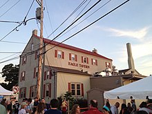
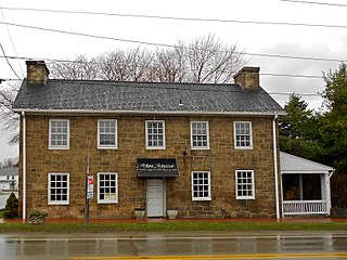
Eagle Tavern in Eagle, Pennsylvania, is a historic tavern built in 1702 situated at the intersection of Pottstown Pike and Little Conestoga Road. The current building was built over the original structure in 1799. The original Eagle Tavern liquor licence dates to August 17, 1727. It was a hangout for the notorious outlaws, the Doan brothers, who operated before the Revolutionary War.