Erie County, Pennsylvania

Last updated

Erie County
ErieCtyCourthouse EriePA.JPG
Flag of Erie County, Pennsylvania.png
Seal of Erie County, Pennsylvania.png
Map of Pennsylvania highlighting Erie County.svg
Location within the U.S. state of Pennsylvania
Pennsylvania in United States.svg
Pennsylvania's location within the U.S.
Coordinates: 42°06′N80°06′W / 42.1°N 80.1°W / 42.1; -80.1
CountryFlag of the United States.svg United States
StateFlag of Pennsylvania.svg  Pennsylvania
FoundedNovember 7, 1803
Named for Erie people
Seat Erie
Largest cityErie
Area
  Total1,558 sq mi (4,040 km2)
  Land799 sq mi (2,070 km2)
  Water759 sq mi (1,970 km2)  49%
Population
 (2020)
  Total270,876
  Density339.1/sq mi (130.9/km2)
Time zone UTC−5 (Eastern)
  Summer (DST) UTC−4 (EDT)
Congressional district 16th
Website www.eriecountypa.gov

Erie County is a county in the Commonwealth of Pennsylvania. It is the northernmost county in Pennsylvania. As of the 2020 census, the population was 270,876. [1] Its county seat is Erie. [2] The county was created in 1800 and later organized in 1803. [3] The county is part of the Northwest Pennsylvania region of the state. [lower-alpha 1]

Contents

Erie County comprises the Erie–Meadville combined statistical area.

History

Erie County was established on March 12, 1800, from part of Allegheny County, which absorbed the lands of the disputed Erie Triangle in 1792. Prior to 1792, the region was claimed by both New York and Pennsylvania and so no county demarcations were made until the federal government intervened. [4]

Since Erie County and its newly established neighboring Counties of Crawford, Mercer, Venango, and Warren were initially unable to sustain themselves, a five-county administrative organization was established at Crawford County's Meadville to temporarily manage government affairs in the region. Erie first elected its own county officials in 1803. [5] Unfortunately, on March 23, 1823, the Erie County Courthouse burned and all county records to that point were destroyed. [6]

The county was originally settled by immigrants of "Yankee" stock (immigrants from New England and the western part of New York descended from the English Puritans whose ancestors settled New England in the colonial era). Erie County resembled Upstate New York more than it did Pennsylvania with its population primarily consisting of settlers from Connecticut, Rhode Island and Maine. [7] Roads were laid out, post routes established, public buildings erected and people were invited to move there. The original settlers were entirely of New England origins or were Yankees from upstate New York whose families had moved to that place from New England only one generation earlier, in the aftermath of the Revolutionary War. This resulted in Erie County being culturally very contiguous with early New England culture.

Erie County was part of the Underground Railroad giving slaves the ability to gain freedom through Lake Erie into Canada, East through New York State, or to stay in Erie with the help of abolitionists and the free black community. Today, the "Journey to Freedom" educational program provides an interactive program on the Underground Railroad experience. [8]

Geography

According to the U.S. Census Bureau, the county has a total area of 1,558 square miles (4,040 km2), of which 799 square miles (2,070 km2) is land and 759 square miles (1,970 km2) (49%) is water. [9] It is the largest county in Pennsylvania by total area. With the exception of a high ridge several miles from the lake, running nearly parallel with its shore, the terrain is generally rolling and well watered. [10] It is the only county in the state that occupies a significant amount of land north of the 42nd parallel.

There are two cities in Erie County: the city of Erie and the city of Corry. Other notable population centers include Millcreek, Harborcreek and Fairview townships, and the boroughs of Edinboro, North East, Girard, Waterford and Union City. Erie County is bordered on the northeast by Chautauqua County, New York, on the east by Warren County, on the south by Crawford County, and on the west by Ashtabula County, Ohio. Directly north of the county is Lake Erie. This position on the water makes Erie County the only county in Pennsylvania to share a border with Canada, which is located on the far shore of the lake.

Most of the county has a warm-summer humid continental climate (Dfb), except at lower elevations near enough to the lake, where a hot-summer humid continental climate (Dfa) exists. Average monthly temperatures in downtown Erie range from 26.4 °F in January to 70.8 °F in July, while in Corry they range from 23.8 °F in January to 68.2 °F in July. [11] The hardiness zone in most of Erie County by area is 6a. It has warmed to 7a along the Lake and the area between the shore and a line a little south of Interstate 90 is 6b.

Because of its location in the northwesternmost part of the state, Erie County is the only county to border both New York and Ohio, and is also the only county in the state on the Canadian border.

Adjacent counties

Major highways

Demographics

Historical population
CensusPop.Note
1800 1,468
1810 3,758156.0%
1820 8,553127.6%
1830 17,04199.2%
1840 31,34483.9%
1850 38,74223.6%
1860 49,43227.6%
1870 65,97333.5%
1880 74,68813.2%
1890 86,07415.2%
1900 98,47314.4%
1910 115,51717.3%
1920 153,53632.9%
1930 175,27714.2%
1940 180,8893.2%
1950 219,38821.3%
1960 250,68214.3%
1970 263,6545.2%
1980 279,7806.1%
1990 275,572−1.5%
2000 280,8451.9%
2010 280,566−0.1%
2020 270,876−3.5%
[12]

According to the 2010 census, there were 280,566 people, 110,413 households, and 70,196 families residing in the county. The population density was 351.2 inhabitants per square mile (135.6/km2). There were 119,138 housing units at an average density of 149.1 per square mile (57.6/km2). The racial makeup of the county was 88.2 percent White, 7.2 percent Black or African American, 0.2 percent Native American, 1.1 percent Asian, 0.03 percent Pacific Islander, 1.2 percent from other races, and 2.1 percent from two or more races. A further 3.4 percent of the population were Hispanic or Latino of any race. 24.4% were of German, 12.5% Polish, 12.3% Italian, 10.1% Irish, 6.5% English and 6.4% American ancestry.

Of the total number of household, 27.2 percent had children under the age of 18 living with them, 45.4 percent were married couples living together, 13.2 percent had a female householder with no husband present, and 36.4 percent were non-families. 29.3 percent of all households were made up of individuals, and 11.3 percent had someone living alone who was 65 years of age or older. The average household size was 2.42 and the average family size was 3.00.

In the county, the population was spread out, with 26.5 percent under the age of 20. The median age was 38.6 years. For every 100 females there were 96.73 males.

2020 census

Erie County Racial Composition [13]
RaceNum.Perc.
White (NH)219,18081%
Black or African American (NH)19,8217.32%
Native American (NH)3430.13%
Asian (NH)6,3582.35%
Pacific Islander (NH)580.02%
Other/Mixed (NH)13,0864.83%
Hispanic or Latino 12,0304.44%

Metropolitan Statistical Area

Map of the Erie-Meadville, PA Combined Statistical Area (CSA), composed of:
.mw-parser-output .legend{page-break-inside:avoid;break-inside:avoid-column}.mw-parser-output .legend-color{display:inline-block;min-width:1.25em;height:1.25em;line-height:1.25;margin:1px 0;text-align:center;border:1px solid black;background-color:transparent;color:black}.mw-parser-output .legend-text{}
Erie, PA Metropolitan Statistical Area
Meadville, PA Micropolitan Statistical Area Erie-Meadville, PA CSA 2014.jpg
Map of the Erie-Meadville, PA Combined Statistical Area (CSA), composed of:

The United States Office of Management and Budget [14] has designated Erie County as the Erie, PA Metropolitan Statistical Area (MSA). As of the 2010 U.S. Census [15] the metropolitan area ranked 11th-most populous in Pennsylvania and the 164th-most populous in the United States with a population of 280,566.

Erie County is part of the larger Erie-Meadville, PA Combined Statistical Area (CSA), which combines the populations of Erie County as well as Crawford County to the south. The Combined Statistical Area ranked seventh in Pennsylvania and 102nd-most populous in the United States with a population of 369,331.

Largest populations in Erie County

2015 rankCityType2016 estimate2010 CensusChangeHighest Population (Year)
1 Erie City98,593101,786−3.14%138,440 (1960)
2 Millcreek Township53,77353,515+0.48%54,256 (2013)
3 Harborcreek Township17,51717,234+1.64%17,629 (2014)
4 Fairview Township10,15010,102+0.48%10,217 (2013)
5 Summit Township6,9166,603+4.74%6,916 (2016)
6 Corry City6,3606,605−3.71%7,911 (1950)
7 North East Township6,2696,315−0.73%7,702 (2000)
8 Edinboro Borough6,2366,438−3.14%7,736 (1990)

Government and politics

Prior to 1960, Erie County was primarily Republican in presidential elections, only backing Democratic Party candidates in four elections from 1888 to 1956. Since 1960, it has become primarily Democratic, with only four Republican wins in the county in presidential elections from 1960 to the present. Nevertheless, since the 2016 presidential election, the county has become increasingly competitive, with Donald Trump narrowly winning the county that year, and Joe Biden narrowly flipping the county in 2020.

United States presidential election results for Erie County, Pennsylvania [16] [17]
Year Republican Democratic Third party
No.%No.%No.%
2020 66,86948.63%68,28649.66%2,3391.70%
2016 60,06948.01%58,11246.44%6,9485.55%
2012 49,02541.16%68,03657.12%2,0531.72%
2008 50,35139.25%75,77559.07%2,1451.67%
2004 57,37245.57%67,92153.95%6050.48%
2000 49,02743.64%59,39952.88%3,9093.48%
1996 39,88436.66%57,50852.86%11,39910.48%
1992 39,28333.35%56,38147.86%22,14018.79%
1988 48,30646.76%53,91352.19%1,0811.05%
1984 55,86051.12%52,47148.02%9350.86%
1980 48,91847.42%45,94644.54%8,2988.04%
1976 49,64146.20%55,38551.55%2,4132.25%
1972 61,54258.22%42,02239.75%2,1492.03%
1968 43,13443.20%51,60451.68%5,1095.12%
1964 31,39329.93%72,94469.55%5490.52%
1960 51,52548.82%53,72350.90%2950.28%
1956 54,43061.46%33,80238.17%3230.36%
1952 48,83656.89%36,61942.66%3910.46%
1948 33,80653.45%28,15944.52%1,2802.02%
1944 35,24751.40%32,91247.99%4190.61%
1940 36,60853.28%31,73546.18%3710.54%
1936 25,60739.18%33,04250.56%6,70610.26%
1932 18,37145.43%19,59248.44%2,4796.13%
1928 30,54260.97%19,27838.48%2770.55%
1924 19,48061.29%3,50211.02%8,80227.69%
1920 19,46563.68%6,31120.65%4,79315.68%
1916 8,93343.30%9,64146.73%2,0569.97%
1912 4,95826.93%5,63330.60%7,81742.47%
1908 10,82855.76%6,17331.79%2,41812.45%
1904 11,95162.84%5,11926.92%1,94810.24%
1900 11,81658.47%7,28136.03%1,1105.49%
1896 11,81954.74%9,21042.65%5632.61%
1892 8,91849.76%7,58942.34%1,4167.90%
1888 9,37254.23%7,11141.15%7984.62%
1884 9,23054.77%6,72539.91%8965.32%
1880 8,75255.12%6,47140.76%6544.12%

The county seat of government is in Erie. The county has a home-rule charter and is run by a county executive. The current County Executive is Brenton Davis. [18] Davis assumed the office on January 3, 2022, following the retirement of County Executive Kathy Dahlkemper. The remaining elected officials of the executive branch are the Erie County Controller, Erie County Coroner, Erie County District Attorney, Erie County Sheriff, and Erie County Clerk of Records. see latest list

Erie County Executives
NamePartyTerm startTerm end
Russell Robison Republican 19781982
Judith M. Lynch Democratic 19822002
Richard SchenkerRepublican20022006
Mark A. DiVecchioDemocratic20062010
Barry GrossmanDemocratic20102014
Kathleen Dahlkemper Democratic20142022
Brenton DavisRepublican2022Incumbent

Judiciary

The judiciary is made up of nine judges serving the Erie County Court of Common Pleas and fifteen magisterial district judges serve the district courts. Court administration is managed by a district court administrator, deputy court administrator, and assistant court administrator. The Erie County Courthouse is located near Perry Square in downtown Erie. Erie County also operates a County Prison, and a combined 911/Emergency Management Agency under the Erie County Department of Public Safety, which is located in Summit Township.

Politics

As of February 5, 2024, there are 173,388 registered voters in Erie County. [19]

Chart of Voter Registration

   Democratic (46.16%)
   Republican (39.14%)
   Independent (10.40%)
  Third Party (4.30%)

Unlike most of northwestern Pennsylvania, Erie County tends to lean Democratic in statewide and national elections. All four statewide winners carried the county in 2008. The margins of victory for the Democratic presidential candidate in the 2000, 2004, and 2008 elections in Erie County were 9, 8, and 20 percentage points, respectively.

The county is considered a bellwether politically. [20]

State senate

State House of Representatives

United States House of Representatives

United States Senate

Education

Public school districts

Map of Erie County, Pennsylvania School Districts Map of Erie County Pennsylvania School Districts.png
Map of Erie County, Pennsylvania School Districts

Approved private schools

Community College

After years of advocacy on the issue, Erie County Council approved sponsorship of an Erie County Community College on June 28, 2017. Council Chairman Jay Breneman and colleagues Andre Horton, Kathy Fatica and Fiore Leone voted in favor of sponsoring the community college, which was later signed by County Executive Kathy Dahlkemper. The County Executive's administration took the lead in presenting the proposal to the Pennsylvania State Board of Education for approval, supported by a cross-section of business, civic, labor, and community leaders. [21] [22]

Recreation

There are two Pennsylvania state parks in Erie County and both are on the shores of Lake Erie.

Recreation

Annual events

Libraries

The foremost public library in Erie is part of the Erie County library system, which consists of five branches and a bookmobile. [24] The Raymond M. Blasco, M. D. Memorial Library, named for its benefactor, opened in 1996. [25] Now called the Main Library or the Erie County Public Library, is the third-largest library in Pennsylvania. [26] It is connected to the Erie Maritime Museum, both of which are part of a bayfront improvement project that includes the Bayfront Convention Center and the Bicentennial Tower on Dobbins Landing. The Main Library is praised for its waterfront views of the Presque Isle Bay, where the historic U.S. Brig Niagara is often located. The library was moved to this location approximately 25 years ago, from its previous home in the center of downtown Erie. The library's renovation directly contributed to the revitalization of the waterfront, which was previously underdeveloped. [27]

The second floor of the Main Library is home to an art collection, containing historic pieces like Summer Afternoon, Isle of Shoals by Frederick Childe Hassam. The display also features several local artists. [27] The library works with the International Institute of Erie (IIE) to offer tours of the library, a collection of foreign-language books, and other practical information about immigration processes. [27] The library also provides a heritage room where one can conduct genealogy research concerning their ancestors who resided in Erie County or Northwest Pennsylvania. [28]

The four remaining libraries within the Erie County library system are the Edinboro Branch Library, Iroquois Avenue Branch Library, Lincoln Community Center Branch Library, and Millcreek Branch Library. [24] The other public libraries of Erie County include the Albion Area Public Library, Corry Public Library, McCord Memorial Library, Rice Avenue Public Library, Union City Public Library, and Waterford Public Library. [29]

Communities

Map of Erie County, Pennsylvania with Municipal Labels showing Cities and Boroughs (red), Townships (white), and Census-designated places (blue). Map of Erie County Pennsylvania With Municipal and Township Labels.png
Map of Erie County, Pennsylvania with Municipal Labels showing Cities and Boroughs (red), Townships (white), and Census-designated places (blue).

Under Pennsylvania law, there are four types of incorporated municipalities: cities, boroughs, townships, and, in at most two cases, towns. There are 38 incorporated municipalities in Erie County, including 2 cities, 14 boroughs, and 22 townships. The following cities, boroughs and townships are located in Erie County:

Cities

Boroughs

Townships

Census-designated places

Census-designated places are geographical areas designated by the U.S. Census Bureau for the purposes of compiling demographic data. They are not actual jurisdictions under Pennsylvania law. Other unincorporated communities, such as villages, may be listed here as well.

Population ranking

The population ranking of the following table is based on the 2010 census of Erie County. [15]

county seat

RankCity/Town/etc.Municipal typePopulation (2010 Census)
1Erie City101,786
2 Northwest Harborcreek CDP8,949
3 Corry City6,605
4 Edinboro Borough6,438
5 North East Borough4,294
6 Lawrence Park CDP3,982
7 Wesleyville Borough3,341
8 Union City Borough3,320
9 Girard Borough3,104
10 Lake City Borough3,031
11 Fairview CDP2,348
12 Penn State Erie (Behrend) CDP1,629
13 Waterford Borough1,517
14 Albion Borough1,516
15 Avonia CDP1,205
16 Cranesville Borough638
17 Platea Borough430
18 Mill Village Borough412
19 Wattsburg Borough403
20 McKean Borough388
21 Elgin Borough218

See also

Related Research Articles

<span class="mw-page-title-main">Warren County, Pennsylvania</span> County in Pennsylvania, United States

Warren County is a county in the Commonwealth of Pennsylvania. As of the 2020 census, the population was 38,587. Its county seat is Warren. The county was established in 1800 from parts of Allegheny and Lycoming counties; attached to Crawford County until 1805 and then to Venango County until Warren was formally established in 1819.

<span class="mw-page-title-main">Mercer County, Pennsylvania</span> County in Pennsylvania, United States

Mercer County is a county in the Commonwealth of Pennsylvania. As of the 2020 census, the population was 110,652. Its county seat is Mercer, and its largest city is Hermitage. The county is part of the Northwest Pennsylvania region of the state.

<span class="mw-page-title-main">Crawford County, Pennsylvania</span> County in Pennsylvania, United States

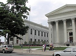
Crawford County is a county in the Commonwealth of Pennsylvania. As of the 2020 census, the population was 83,938. Its county seat is Meadville. The county was created on March 12, 1800, from part of Allegheny County and named for Colonel William Crawford. The county is part of the Northwest Pennsylvania region of the state.

<span class="mw-page-title-main">Presque Isle County, Michigan</span> County in Michigan, United States

Presque Isle County is a county in the Lower Peninsula of the U.S. state of Michigan. As of the 2020 census, the population was 12,982. The county seat is Rogers City. The county was authorized by state legislative action on April 1, 1840, but the county government was not established until 1871. The government was reorganized in 1875.

<span class="mw-page-title-main">Edinboro, Pennsylvania</span> Borough in Pennsylvania, United States

Edinboro is a borough in Erie County, Pennsylvania, United States. It is part of the Erie Metropolitan Statistical Area. As home to Edinboro University of Pennsylvania, it is a small college town, as well as a resort community. The population was 4,920 at the 2020 census, down from 6,438 in 2010.

<span class="mw-page-title-main">Erie, Pennsylvania</span> City in Pennsylvania, United States

Erie is a city on the south shore of Lake Erie and the county seat of Erie County, Pennsylvania, United States. It is the fifth-most populous city in Pennsylvania and the most populous in Northwestern Pennsylvania with a population of 94,831 at the 2020 census. The Erie metropolitan area, equivalent to all of Erie County, had a population of 270,876 in 2020. Erie is located approximately 80 miles (130 km) from Buffalo, 90 miles (140 km) from Cleveland, and 120 miles (190 km) from Pittsburgh.

<span class="mw-page-title-main">Fairview Township, Erie County, Pennsylvania</span> Township in Pennsylvania, United States

Fairview Township is a township in Erie County, Pennsylvania, United States. Situated on the southern shore of Lake Erie, it was one of the county's sixteen original townships, and was founded in 1797.

<span class="mw-page-title-main">Harborcreek Township, Pennsylvania</span> Township in Pennsylvania, United States

Harborcreek Township is a township in Erie County, Pennsylvania, United States. The population was 16,630 at the 2020 census, down from 17,234 at the 2010 census, up from 15,178 in 2000. It is part of the Erie Metropolitan Statistical Area.

<span class="mw-page-title-main">Millcreek Township, Erie County, Pennsylvania</span> Township in Pennsylvania

Millcreek Township is a township in Erie County, Pennsylvania, United States. The population was 54,065 at the 2020 census, making it the 14th-largest municipality in the state. and the largest township in Western Pennsylvania.

<span class="mw-page-title-main">Summit Township, Erie County, Pennsylvania</span> Township in Pennsylvania, United States

Summit Township is a township in Erie County, Pennsylvania. The population was 7,341 at the time of the 2020 census, up from 6,603 at the 2010 census.

<span class="mw-page-title-main">Presque Isle State Park</span> Pennsylvania state park on Lake Erie

Presque Isle State Park is a 3,112-acre (1,259 ha) Pennsylvania State Park on an arching, sandy peninsula that juts into Lake Erie, 4 miles (6 km) west of the city of Erie, in Millcreek Township, Erie County, Pennsylvania, in the United States. The peninsula sweeps northeastward, surrounding Presque Isle Bay along the park's southern coast. It has 13 miles (21 km) of roads, 21 miles (34 km) of recreational trails, 13 beaches for swimming, and a marina. Popular activities at the park include swimming, boating, hiking, biking, and birdwatching.

<span class="mw-page-title-main">Pennsylvania Route 5</span> State highway in Erie County, Pennsylvania, United States

Pennsylvania Route 5 is a westward continuation of New York State Route 5. Located in the Commonwealth of Pennsylvania, in the United States, it runs from North East, Pennsylvania at the New York-Pennsylvania border to Springfield Township in western Erie County, for a total of 44.85 miles (72.18 km).

The 4th District of the Pennsylvania House of Representatives is located in northwest Pennsylvania and has been represented by Jake Banta since 2023.

<span class="mw-page-title-main">Pennsylvania Route 832</span> State highway in Erie County, Pennsylvania, US

Pennsylvania Route 832, known locally as Sterrettania Road and Peninsula Drive, is a state highway located in Erie County, Pennsylvania. Its northern terminus is at the entrance to Presque Isle State Park in Erie. The southern terminus is at PA 98, two miles (3 km) west of Sterrettania in Fairview Township. PA 832 has junctions with U.S. Route 20, PA 5 and PA 5 Alternate. PA 832 is exit 18 off Interstate 90 (I-90). PA 832 was designated in 1928 between PA 99 and Presque Isle. The route was extended south to US 20 by 1940. PA 832 was further extended to I-90 by 1959 and PA 98 by 1970.

<span class="mw-page-title-main">Interstate 90 in Pennsylvania</span> Section of Interstate Highway in Erie County, Pennsylvania, United States

Interstate 90 (I-90) within the US state of Pennsylvania spans 46.297 miles (74.508 km), all within Erie County, from the Ohio border near West Springfield to the New York border near North East. I-90 is the primary west–east highway in the Erie area, passing south of downtown and having interchanges with I-79, which connects Downtown Erie to southern Pennsylvania and beyond, and I-86, linking Erie to the Southern Tier of New York. U.S. Route 20 (US 20), which has an interchange with I-90 near the New York–Pennsylvania border, parallels I-90 across the county. Throughout its length, I-90 has also been designated as the AMVETS Memorial Highway, with signs posted at each state line.

Lake Erie Watershed is a major drainage catchment in northwestern Pennsylvania, United States, consisting of lands with direct runoff and sub-watersheds with waterways that flow into Lake Erie and Presque Isle Bay from Crawford and Erie counties, as well as from New York. The watershed is part of the Lake Erie Basin.

Pennsylvania State Senate District 49 includes part of Erie County. It is currently represented by Republican Dan Laughlin.

<span class="mw-page-title-main">U.S. Route 20 in Pennsylvania</span> Segment of American highway

U.S. Route 20 (US 20) is an east–west United States Numbered Highway in Pennsylvania, which clips the northwestern corner of the state, running entirely in Erie County. While it is part of the nation's longest road, it features the shortest segment of any two-digit U.S. Route in the commonwealth. Although bypassed by Interstate 90 (I-90) as the primary through route in the area, heavy traffic has led to nearly the entire highway being widened to four lanes in width.

<span class="mw-page-title-main">Erie–Meadville combined statistical area</span> Place in Pennsylvania, United States

The Erie–Meadville, PA Combined Statistical Area (CSA) is made up of two counties in northwestern Pennsylvania. The United States Office of Management and Budget has recognized the Erie and Meadville areas along with the counties of Erie and Crawford to make a Combined Statistical Area, located in northwestern Pennsylvania. Though these county line boundaries are rather arbitrary since Erie serves as the regional hub for the bordering areas of southwestern New York and northeastern Ohio, including the cities of Jamestown and Conneaut.

References

  1. Includes Erie, Mercer, Crawford and Venango Counties
  1. "2020 Population and Housing State Data". United States Census Bureau. Retrieved August 13, 2021.
  2. "Find a County". National Association of Counties. Archived from the original on May 31, 2011. Retrieved June 7, 2011.
  3. "Pennsylvania: Individual County Chronologies". Pennsylvania Atlas of Historical County Boundaries. The Newberry Library. 2008. Archived from the original on March 25, 2015. Retrieved March 12, 2015.
  4. "State and County Maps of Pennsylvania". Archived from the original on February 18, 2013. Retrieved May 31, 2012.
  5. Whitman, Benjamin; et al. (1884). "Part II, Chapter I". History of Erie County, Pennsylvania: Containing a History of the County, Its Townships, Towns, Villages, Schools, Churches, Industries, Etc. Vol. 1. Erie, Pennsylvania: Warner, Beers and Company. p.  137.
  6. Whitman, Benjamin; et al. (1884). "Chapter XVII County Buildings". History of Erie County, Pennsylvania: Containing a History of the County, Its Townships, Towns, Villages, Schools, Churches, Industries, Etc. Vol. 1. Erie, Pennsylvania: Warner, Beers and Company. p.  283.
  7. Rosenberry, Lois Kimball Mathews (1909). The expansion of New England: the spread of New England settlement and institutions to the Mississippi River, 1620–1865. Boston: Houghton Mifflin. p. 151.
  8. Meyer, Melinda.Journey to Freedom National Park Service. Erie County Historical Society. November 17, 2010. http://www.nps.gov. (December 6, 2012)
  9. "2010 Census Gazetteer Files". United States Census Bureau. August 22, 2012. Retrieved March 5, 2015.
  10. "Erie. II. A county of Pennsylvania"  . Encyclopedia Americana . 1920.
  11. "PRISM Climate Group at Oregon State University".
  12. "Census 2020".
  13. "P2 HISPANIC OR LATINO, AND NOT HISPANIC OR LATINO BY RACE – 2020: DEC Redistricting Data (PL 94-171) – Erie County, Pennsylvania".
  14. "Office of Management and Budget". February 7, 2017.
  15. 1 2 "2010 Census". Archived from the original on December 6, 2013. Retrieved May 25, 2014.
  16. Leip, David. "Dave Leip's Atlas of U.S. Presidential Elections". uselectionatlas.org.
  17. The leading "other" candidate, Progressive Theodore Roosevelt, received 5,019 votes, while Socialist candidate Eugene Debs received 1,972 votes, Prohibition candidate Eugene Chafin received 800 votes, and Socialist Labor candidate Arthur Reimer received 26 votes.
  18. Rao, A. J. "Davis vows to usher in 'era of change,' unity as new Erie County executive". Erie Times-News. Retrieved January 18, 2022.
  19. Pennsylvania Department of State (February 5, 2024). "Voter registration statistics by county". dos.pa.gov. Retrieved February 5, 2024.
  20. David Wasserman (October 6, 2020), "The 10 Bellwether Counties That Show How Trump Is in Serious Trouble", The New York Times
  21. Erie County Council approves community college sponsorship
  22. "Community College Proposal". Archived from the original on November 14, 2019. Retrieved November 14, 2019.
  23. Pennsylvania Department of Community and Economic Development, Presque Isle State Park: Tranquility Found. Retrieved May 8, 2014.
  24. 1 2 "Facilities – Erie County Public Library".
  25. "History of the Library – Erie County Public Library".
  26. "Facts". www.ci.erie.pa.us. Archived from the original on August 8, 2007. Retrieved January 11, 2022.
  27. 1 2 3 "This Seaport is Now a Library, but It's Still a Portal to the World". The Atlantic . September 5, 2016.
  28. "Genealogy – Heritage Room at Blasco – Erie County Public Library".
  29. "Public Libraries of Erie County".

42°06′N80°06′W / 42.10°N 80.10°W / 42.10; -80.10