Geology of Pennsylvania

Last updated

The physiographic provinces of Pennsylvania Physiographic provinces of Pennsylvania, Pennsylvania Geological Survey, 4th ser., Map 13, Pennsylvania Geological Survey of the PennDepCons&NatRes.jpg
The physiographic provinces of Pennsylvania
Eastern Pennsylvania has abundant anthracite coal, a high-value energy source. Coal anthracite.jpg
Eastern Pennsylvania has abundant anthracite coal, a high-value energy source.

The Geology of Pennsylvania consists of six distinct physiographic provinces, three of which are subdivided into different sections. Each province has its own economic advantages and geologic hazards and plays an important role in shaping everyday life in the state. From the southeast corner to the northwest corner of the state, the include: the Atlantic Plain Province province, the Piedmont Province, the New England Province, the Ridge and Valley Province, the Appalachain Province, and the Central Lowlands Province. [1]

Contents

A majority of the rocks in Pennsylvania exposed at the surface are sedimentary and were deposited during the Paleozoic Era. Almost all of the metamorphic and igneous rocks are confined to the southeast portion of the state. A total of four orogenies have affected the rocks of the Commonwealth including the Grenville orogeny, the Taconic orogeny, the Acadian orogeny, and the Appalachian orogeny. The Appalachian event has left the most evidence and has continued to shape the landscape of the state. The Pennsylvania terrain has also been affected by continental rifting during the Mesozoic era. [2]

Pleistocene glaciers have also repeatedly visited the state over the last 100,000 years. These glaciers have left some evidence and carved out much of the landscape of the northern tier of the state. [2]

A rock with high economic value from Pennsylvania is anthracite coal. Before mining began, there was an estimated 22.8 billion tons of anthracite in Pennsylvania. In 2001, 12 billion tons still remained in the ground, most of which was not economically feasible to mine. [3] American geologists recognized the importance of Pennsylvania's coal region and named the Upper Carboniferous Period the Pennsylvanian Period because of the abundance of coal in the state. Despite this, Celestine was proposed as the state mineral in 2002. The proposal however, was not approved by the state legislature. [4] [5]

Pennsylvania is also home to the famous Drake Oil Well in Titusville which helped give rise to the modern oil industry and two brand name motor oils, Quaker State (now owned by Royal Dutch Shell) and Pennzoil. Pennsylvania also has reserves of natural gas from both deeply buried source rocks and coal-bed areas.

Atlantic Coastal Plain

One of the smallest physiographic provinces in the state is confined to Philadelphia, Delaware, and Bucks counties along the Delaware River. Local relief is less than 200 feet (61 m) and much of the bedrock is buried under recent alluvial deposits. On the geologic map, "Trenton Gravel" is used to describe most of these sediments. However, much of the alluvial sediments that exist here are sand, silt, and clays. [6] The traditional boundary of the coastal plain is the Fall Line. The coastal plain in Pennsylvania was once home to thousands of acres of fresh water tidal marsh. This was important in the early development of Philadelphia and Chester. [7] Many of the small tributaries to the Delaware have cut small but impressive gorges into the bedrock, including the Ridley Creek, the Chester Creek, and the Wissahickon Creek. Flash floods are becoming a local problem in the province. [2]

Piedmont

The Piedmont in Pennsylvania is divided into three distinct sections: the Piedmont Uplands, the Piedmont Lowlands, and the Gettysburg-Newark Lowlands. Much of the Piedmont is becoming urbanized and developed. Some of the best farmland in the state is in this region, specifically Lancaster and Chester counties.

Piedmont Uplands

The top plate illustrates the tectonic setting for the deposition of much of the sediments that make up this section. Taconic orogeny.gif
The top plate illustrates the tectonic setting for the deposition of much of the sediments that make up this section.

This section is characterized by the metamorphic rocks that provide much of the bedrock for this area. The oldest exposed rocks in Pennsylvania are found here and consist of the Baltimore Gneiss. [8] These rocks have a complex history and a vast array of different minerals. They are similar in many respects to their cousins in northern and central Maryland, immediately to the south. Much of the rock was altered during the formation of Rodinia during the Grenville orogeny. These rocks eventually provided the platform for the deposition of sediment that would become the Wissahickon Formation during a rifting of Rodinia. Sea floor spreading continued until a passive margin developed along the new Iapetus Ocean and a beach strandline developed. These sediments eventually became the Chickies Formation. [8]

Siliclasitc and carbonate deposition continued through the Cambrian and into the Ordovician period. During the Taconic orogeny, more igneous intrusions and metamorphism occurred as the ancestral Taconic Mountains were pushed up. The sediments that were deposited in a sea between an island-arc and the Iapetus eventually were squeezed and deformed along a subduction zone. The sediments deposited in that sea are now located in the Great Valley section. (See below) The sediments placed from the rifting of Rodinia became the roots of the ancestral Taconics and went through their first wave of metamorphism during the Taconic orogeny. Additional waves of metamorphism continued up until the Alleghanian orogeny. [8]

Piedmont Lowlands

The lowlands are underlain primarily by more easily eroded rocks such as limestone, dolomite, and phyllite. These rocks are relatively younger in age than the surrounding uplands and are likely the result of a quiet stretch of shallow sea deposition. Some of the rocks deposited during this time are also found in the Great Valley section but have been separated by the Gettysburg-Newark Lowland section. Relief is low and generally never rises above 700 feet (210 m). Karst terrain is problematic in this section. [2]

Gettysburg-Newark Lowlands

This section is a bit misleading since there are hills as high as 1,200 feet (366 m) in this section. It is separated from the rest of the Piedmont sections due to the distinctive rock types found here. Also called the Triassic Basin, most of the bedrock are red sandstone, siltstone, and shale. A few formations are brown and black. The sediment accumulated during the rifting of Pangea in the Triassic age. Also, a basaltic igneous rock called diabase formed dykes and sills later in the Jurassic as the Atlantic Ocean began to form. [9] Much of the rocks from this area have been eroded away, but the more erosion resistant diabase has left hills and small elevated regions throughout the section. The erosion patterns of these rocks played a pivotal role in the Battle of Gettysburg. [10]

Buckingham Valley

A small slice of Paleozoic rocks, mostly carbonates, exists in Buckingham Township. These rocks lie north of the Furlong fault which is an offshoot of the larger Chalfont fault. [11] Buckingham Mountain rises south of the valley and comprises quartzite. The other ridge is less prominent and is underlain by the conglomerates of the Stockton Formation. Karst is a localized problem in this area.

New England

A small and fragmented province in northeastern Pennsylvania called the Reading Prong is akin to the crystalline bedrock found in much of New England. This is the southern end of the Hudson Highlands of New York and New Jersey (known as the Ramapo Mountains in New Jersey) and the Taconic Mountains of New York. The granitic rocks and quartzite of this area are highly metamorphosed and are Pre-Cambrian to Cambrian in age. Hills and ridges are locally steep and rounded at the top and form the hills around Reading, and to the south of the Lehigh Valley on South Mountain. [2]

Ridge and valley

This region in Pennsylvania, made famous by NASA's LANDSAT images, is the second-largest in the state and home to the famous anthracite fields. The rocks here are severely folded and contain numerous anticlines and synclines that plunge and fold back over each other. There are numerous thrust faults that help create a chaotic mess. Most of the deformation is result of continent to continent collision during the Alleghenian orogeny. There are seven distinct regions of the province and they are listed below. Much of the drainage patterns in the province is trellis.

South Mountain

South Mountain is the northern tip of the Blue Ridge Mountains. This region is characterized by broad flat ridges with deep narrow valleys. The rocks here are highly metamorphosed igneous and sedimentary rocks with some occasional dolomite. These rocks are Pre-Cambrian in age. [2]

Great Valley

The Great Appalachian Valley is a long broad valley that extends from Canada to Alabama. In Pennsylvania, the valley is known by three names: (listed from north to south) the Lehigh Valley, the Lebanon Valley, and the Cumberland Valley. Rocks that characterize this region include: limestone, dolomite, slate, shale, sandstone, siltstone, and some scattered basalt. Almost all of the rocks in the Great Valley in Pennsylvania are Ordovician in age and were deposited during a quiet period before the Taconic orogeny. The limestones and dolomites of this area are extensively quarried in Pennsylvania. These carbonate rocks are used for variety of purposes including, crushed stone, cement manufacturing, fertilizers, and coal-mine dust (reduces acid mine drainage) [12] Karst features are problematic in the Great Valley.

Blue Mountain

Lehigh Gap from its east peak Blue Mountain at Lehigh Gap.jpg
Lehigh Gap from its east peak

The Blue Mountain or Blue Ridge region, like the ridgelines to its north and west, is one of a series of near parallel ridges that run for tens of miles, and are equally likely to be called Ridge or Mountain. Hence Blue Mountain is not to be confused with the Blue Ridge Mountains but instead, represents the sharp escarpment, a step in elevation separating the Appalachian Mountains from the pastoral basin famous as the landscape associated with the Pennsylvania Dutch in southern Pennsylvania called the Great Valley (A 'Physiographic Province', as are these section titles). Many of Pennsylvania's water gaps cut through Blue Mountain including Delaware Water Gap, Lehigh Gap, Schuylkill Gap, Susquehanna Gap, and Swatara Gap. Also along the ridge, many "wind gaps" also exist. (see separate article) The rocks of the Blue Mountain section include mostly Silurian aged sandstone, conglomerate, siltstone, shale, and some limestone. Blue mountain is also known by the names Kittatinny Mountain (especially in New Jersey) and Hawk Mountain. One of the most prominent rock types of this section is the Shawangunk Formation which is named after the Shawangunk Ridge of New York.

The sediments that comprise Blue Mountain were deposited as a result of the highlands that formed after the Taconic orogeny. The first wave of sediments were coarse, gray, and poorly sorted. (The Shawngunk Formation) This combination of depositional features means that the source area was relatively close and deposited in a moist climate. These sediments grade into finer reddish sands and silts, (Bloomsburg Formation) as the source area became more distant and/or less productive. The climate during this time was drier. [2]

Anthracite Upland

Arguably the most complex and most studied section in the Pennsylvania. The state's Ridge and Valley province is home to one of Pennsylvania's most profitable coal fields in history, containing high-grade anthracite coal. The sediments deposited during the Mississippian Period came from highlands located to the southeast. Waves of mountain-building occasionally brought coarser-grained sediments onto the plain. As the mountains eroded, the sediments became more fine-grained. As the highlands became more distant, or eroded, the sands would grade into silt or clay.

Since the North American Plate was near the equator, a tropical climate existed and allowed dense forests to flourish. Beginning in the Late Mississippian, forests of Lycopodiophyta, Arthrophyta, Pteridophyta, and Pteridospermatophyta began to grow in these plains. [13] As the conditions became more favorable for the dense forests to survive for hundred of thousands of years, much of the dead plant material became preserved in oxygen-depleted environments. The accumulation of this material became preserved in the vast coal deposits. The rise and fall of the mountains, along with changes in sea level, occurred numerous times (often in conjunction). These cyclical stratagraphic events sequences are preserved in the rock record and are often called cyclothems. By the Late Permian, much of the continental plate collision had subsided; the mountain building however, still continued. All of the sediments deposited during the previous 30 million years became folded and faulted as the supercontinent Pangea was finally formed.

It would take 150 million years for the mountains of this area to achieve the shapes seen today. These mountains are steep-sided and valleys are canoe-shaped, largely due to the area's complex folded structure. Most of the coal being mined from this section is from the Pennsylvanian-aged formations. Along with the Mazon Creek fossil field in Illinois, a tremendous amount of plant fossils has been studied from this area. [13] Landslides and acid mine drainage are two principal hazards of the area. In the past, underground mine fires have also been a threat. The Centralia Mine Fire is located within this section of the Ridge and Valley province.

Anthracite Valley

Wyoming Valley and the Susquehanna River in Luzerne County Luzerne (Pennsylvania).jpg
Wyoming Valley and the Susquehanna River in Luzerne County

Detached from the rest of Pennsylvania's anthracite fields, this canoe-shaped valley is also known as the Wyoming Valley and is home to the cities of Scranton and Wilkes-Barre. The largest city in the Wyoming Valley is Scranton, with a population of 77,291. The whole structure of the section is a double plunging syncline with sharp mountain ridges on either side of the valley. The ridges meet just north of Carbondale. The North Branch of the Susquehanna River and the Lackawanna River flow through this valley. Large-scale coal mining and its accompanying industry and railroads have long been abandoned.

Unlike the southern and middle anthracite fields, the anthracite valley has been recently glaciated repeatedly. This action has left many talus slopes at the base of Moosic Mountains, and the soils often contain large boulders that make excavation difficult.

Susquehanna Lowland

This region has also seen its landscape altered by glaciation and the fluvial processes of the Susquehanna River. Most of the ridges in this region are parallel to the streams that drain the area. The Susquehanna also cuts through many of the mountain ridges leading some to believe that the Susquehanna is an ancient river system that existed even before the recent continental glaciation. (Some speculate as far back as the Jurassic Period) [14] None of the mountains in this section rise above 1,700 feet (518 m) and the river valley is as low as 250 feet (76 m).

Appalachian Mountain

View west towards Appalachian Ridge from Clarks Knob Ridgecountry.jpg
View west towards Appalachian Ridge from Clarks Knob

Standard long, narrow, and steep-sided ridges with narrow valleys define the state in LANDSAT photos. Many of the valleys have karst features due to carbonate rocks that reside in them. Road-building generally follows the valleys and rarely cuts across the ridges. The Pennsylvania Turnpike used tunnels cut through the ridges rather than scaling the mountain tops. Mount Nittany, Tuscarora Mountain, Jacks Mountain, Wills Mountain, and Sideling Hill are five prominent mountains in this section. The section contains Cambrian- through Pennsylvanian-aged sediments all deposited into the Appalachian Basin. During the Appalachian orogeny, these sediments became folded, faulted, and moved around. Only during the past few million years has the landscape we see today taken shape. The relatively softer or easily weathered rocks became valleys while the harder and erosion-resistant rocks became the mountain ridges. The development of this landscape continues to this day. Uplift of the province has caused rivers to cut water gaps through the mountain ranges, and has continuously presented new softer rocks in the valleys to be eroded away.

Appalachian Plateau

This is by far the largest province in the state, and most of the rocks in this region are not folded and faulted and sit relatively flat. However, parts of the Appalachian Plateau appear to be mountainous due to erosion caused by streams and glaciers. In western Pennsylvania, large bituminous coal fields exist in rocks with a similar age as the rocks in the anthracite region. Many of the folds in the province are high amplitude and stretch for miles. In glaciated sections, steep canyons developed and much of the terrain have many glacial features. The drainage pattern in this area is dendritic.

Glaciated Pocono Plateau

The Pocono Mountain section of Pennsylvania is the same (geologically speaking) as the Catskill Mountains of New York. The red-green-gray sedimentary rocks of the Catskill Formation are the predominant bedrock type in the Poconos. The elevation of the plateau is between 1,200 feet (366 m) and 2,300 feet (701 m) with only a few steep hills such as Camelback Mountain (Big Pocono). Much of the rock sits in gently dipping horizontal beds, unlike the neighboring Appalachian Mountain section. [2]

Glaciated Low Plateau

Considered a part of the Pocono Plateau, this area lies to the north of the Poconos and contains many of the same types of rock. The local relief is less than that of the Pocono region and bounded to the southeast by the Delaware River. The Big Bushkill Creek cuts a gorge through this section and has many waterfalls, especially around the area of Resica Falls Scout Reservation. Dingmans Falls and Bushkill Falls are waterfalls within the Delaware Water Gap National Recreation Area, also a part of the Endless Mountains region of Pennsylvania.

Glaciated High Plateau

Also an extension of the Catskill Mountains of New York, this section generally has higher elevations than the low plateau section as well as deeper valleys. Younger strata also outcrops in this area with a few minor coal beds. The uplands are rounded or flat along mostly broad hills. An excellent example of the escarpment that divides this section are Ricketts and Ganoga Glen located within Ricketts Glen State Park.

Deep Valleys

This section is home to the Grand Canyon of Pennsylvania and some of the most remote areas of the state. As the name implies, the streams of this area have cut deep valleys with steep sided-slopes on the surrounding ridges. Some of the gorges are at least 1,000 feet (305 m) deep. Much of the area was forested at the end of the 19th century, and much of the area is owned by the Pennsylvania Bureau of Forestry.

Allegheny Front

Snow covered Blue Knob Mountain (3,146 ft.) looming above the countryside Snowcovered.jpg
Snow covered Blue Knob Mountain (3,146 ft.) looming above the countryside

The Allegheny Front section includes the abrupt escarpment that divides the Ridge and Valley Province from the Allegheny Plateau. The region is a large broad ridge with a steep ascent from east to west and rolling hills away from the ridge. The Allegheny Front reaches its highest elevation in Pennsylvania at Blue Knob, 3,136 feet (956 m), an unusual bulge along this symmetrical ridgeline. Streams that cut into the ridge are often shallow and steep.

Allegheny Mountain

This section includes Pennsylvania's highest point, Mount Davis, which stands at 3,213 feet (979 m) above sea level. Many of the mountains are long and broad with relatively shallow and broad valleys. Unlike the Appalachian Mountain section, the streams of this area have not cut deep and well defined valleys into the earth. Much of the drainage pattern is dendritic with a little trellis where erosion resistant rocks have created higher and more well defined ridges. Elevations increase to the south, and Mt. Davis resides only 4.5 miles (7 km) from the Maryland border. A few of the ridge tops contain some low-volatile bituminous coal fields including the Broad Top field. [3] This region is also home to two national stories: the Quecreek Mine Rescue and the crash of United Airlines Flight 93.

Waynesburg Hills

Located in the southwest corner of the state, the Waynesburg hills are another major coal-producing area for the state. Much of the 64.4 billion tons of bituminous coal that is remaining in the state resides under these hills in near horizontal beds. The hills are narrow and steep-sided, with some deeper valleys. [3]

Pittsburgh Low Plateau

Another section that is a significant coal producer. It is similar to the Waynesburg hills section except for higher local relief and deeper valleys. Landslides and mine subsidence are common hazards. [3]

High Plateau

This section consists of high, broad, and flat uplands cut by sharp and shallow river valleys. Much of this area was not covered by the Late Wisconsinan glacier, but there is evidence of pre-Wisconsinan glaciers in the area. Along with the Endless Mountains, it is one of the most remote places in the eastern United States.

Northwestern Glaciated Plateau

This section has been influenced by glaciers and many of the valleys cut into the bedrock trend northwestward- in the direction of the retreating glaciers. There are many signs of glaciers including kames, eskers, kettles, and moraines. This section is home to Pennsylvania's largest natural lake, Conneaut Lake as well as one of the longest eskers in the state, West Liberty Esker. [15] Some of the drainage patterns have shifted and only a few of the streams flow into Lake Erie.

Central Lowlands

Along with the Coastal Plain Province, the smallest province in the state, the central lowlands are a part of the Great Lakes area and exist along a glacial escapement adjacent to Lake Erie.

Geologic features

The following is a list of Pennsylvania geologic features noted for their beauty and/or uniqueness.

Periglacial

Boulder Field at Hickory Run State Park Boulder Field (HRSP).jpg
Boulder Field at Hickory Run State Park

Glacial

Structural

upright=1.1Bear Valley Strip Mine, southwest of Shamokin in the Coal Region Bear Valley Whaleback DCP 0776.jpg
upright=1.1Bear Valley Strip Mine, southwest of Shamokin in the Coal Region

Rock formations

Pennsylvania has been updating its base geologic map last printed in 1980. New research has shifted the names of several formations and promoted or demoted many different sequences on the stratigraphic chart.

See also

Related Research Articles

<span class="mw-page-title-main">Appalachian Mountains</span> Mountain range in eastern North America

The Appalachian Mountains, often called the Appalachians, are a mountain range in eastern to northeastern North America. Here, the term "Appalachian" refers to several different regions associated with the mountain range, and its surrounding terrain. The general definition used is one followed by the US Geological Survey and the Geologic Survey of Canada to describe the respective countries' physiographic regions. The US uses the term Appalachian Highlands and Canada uses the term Appalachian Uplands..

<span class="mw-page-title-main">Geology of the Appalachians</span> Geologic description of the Appalachian Mountains

The geology of the Appalachians dates back more than 1.1 billion years to the Mesoproterozoic era when two continental cratons collided to form the supercontinent Rodinia, 500 million years prior to the later development of the range during the formation of the supercontinent Pangea. The rocks exposed in today's Appalachian Mountains reveal elongate belts of folded and thrust faulted marine sedimentary rocks, volcanic rocks and slivers of ancient ocean floor – strong evidence that these rocks were deformed during plate collision. The birth of the Appalachian ranges marks the first of several mountain building plate collisions that culminated in the construction of the supercontinent Pangea with the Appalachians and neighboring Anti-Atlas mountains near the center. These mountain ranges likely once reached elevations similar to those of the Alps and the Rocky Mountains before they were eroded.

<span class="mw-page-title-main">Ridge-and-Valley Appalachians</span> Physiographic province of the larger Appalachian division

The Ridge-and-Valley Appalachians, also called the Ridge and Valley Province or the Valley and Ridge Appalachians, are a physiographic province of the larger Appalachian Highlands division. The physiographic province is divided into three sections, the Hudson Valley, the Central, and the Tennessee.

<span class="mw-page-title-main">Acadian orogeny</span> North American orogeny

The Acadian orogeny is a long-lasting mountain building event which began in the Middle Devonian, reaching a climax in the early Late Devonian. It was active for approximately 50 million years, beginning roughly around 375 million years ago, with deformational, plutonic, and metamorphic events extending into the Early Mississippian. The Acadian orogeny is the third of the four orogenies that formed the Appalachian orogen and subsequent basin. The preceding orogenies consisted of the Potomac and Taconic orogeny, which followed a rift/drift stage in the Late Neoproterozoic. The Acadian orogeny involved the collision of a series of Avalonian continental fragments with the Laurasian continent. Geographically, the Acadian orogeny extended from the Canadian Maritime provinces migrating in a southwesterly direction toward Alabama. However, the Northern Appalachian region, from New England northeastward into Gaspé region of Canada, was the most greatly affected region by the collision.

<span class="mw-page-title-main">Taconic orogeny</span> Mountain-building period that affected most of New England

The Taconic orogeny was a mountain building period that ended 440 million years ago and affected most of modern-day New England. A great mountain chain formed from eastern Canada down through what is now the Piedmont of the East coast of the United States. As the mountain chain eroded in the Silurian and Devonian periods, sediments from the mountain chain spread throughout the present-day Appalachians and midcontinental North America.

<span class="mw-page-title-main">Geology of Georgia (U.S. state)</span> Overview of the geology of the U.S. state of Georgia

The state of Georgia is commonly divided into four geologic regions that influence the location of the state's four traditional physiographic regions. The four geologic regions include the Appalachian foreland, Blue Ridge, Piedmont, and Coastal Plain. These four geologic regions commonly share names with and typically overlap the four physiographic regions of the state: the Appalachian Plateau and adjacent Valley and Ridge; the Blue Ridge; the Piedmont and the Coastal Plain. The geologic regions of the state, established by geologists based on relationships between stratigraphic units, significantly influence the physiographic regional names used by physical geographers. Geologic regions of the state, however, do not perfectly coincide with physiographic regions of the state. Most geologic regions (terranes) in the state are separated from one another by major thrust faults that formed during the growth of the Appalachian Mountains. The Appalachian foreland, for example, is separated from the geologic Blue Ridge by the Talladega-Cartersville-Great Smoky fault. The geologic Blue Ridge is separated from the geologic Piedmont by the Brevard fault zone. The Fall Line, the surface expression of the Coastal Plain unconformity, is the geologic boundary between the Piedmont and the Coastal Plain.

<span class="mw-page-title-main">Appalachian Highlands</span> Physiographic division of the United States

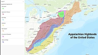
The Appalachian Highlands is one of eight government-defined physiographic divisions of the contiguous (conterminous) United States. The land area is linked together with the Appalachian Uplands of Canada to make up the Appalachian Mountains. Therefore, from a geographic standpoint, the term Appalachian Highlands is not a synonym for the term Appalachian Mountains. The Highlands includes seven physiographic provinces, which is the second level in the physiographic classification system in the United States. At the next level of physiographic classification, called section/subsection, there are 20 unique land areas,.

<span class="mw-page-title-main">Bloomsburg Formation</span>

The Silurian Bloomsburg Formation is a mapped bedrock unit in Pennsylvania, New Jersey, New York and Maryland. It is named for the town of Bloomsburg, Pennsylvania in which it was first described. The Bloomsburg marked the first occurrence of red sedimentary rocks in the Appalachian Basin.

<span class="mw-page-title-main">Tuscarora Sandstone</span> Bedrock unit in Pennsylvania, Maryland, West Virginia, and Virginia, US

The Silurian Tuscarora Formation — also known as Tuscarora Sandstone or Tuscarora Quartzite — is a mapped bedrock unit in Pennsylvania, Maryland, West Virginia, and Virginia, US.

New Jersey is a very geologically and geographically diverse region in the United States' Middle Atlantic region, offering variety from the Appalachian Mountains and the Highlands in the state's northwest, to the Atlantic Coastal Plain region that encompasses both the Pine Barrens and the Jersey Shore. The state's geological features have impacted the course of settlement, development, commerce and industry over the past four centuries.

The Mississippian Mauch Chunk Formation is a mapped bedrock unit in Pennsylvania, Maryland, and West Virginia. It is named for the township of Mauch Chunk, now known as borough of Jim Thorpe, Pennsylvania and for nearby Mauch Chunk Ridge where the formation crops out.

<span class="mw-page-title-main">Geology of West Virginia</span>

West Virginia's geologic history stretches back into the Precambrian, and includes several periods of mountain building and erosion. At times, much of what is now West Virginia was covered by swamps, marshlands, and shallow seas, accounting for the wide variety of sedimentary rocks found in the state, as well as its wealth of coal and natural gas deposits. West Virginia has had no active volcanism for hundreds of millions of years, and does not experience large earthquakes, although smaller tremors are associated with the Rome Trough, which passes through the western part of the state.

<span class="mw-page-title-main">Kittatinny Valley</span>

The Kittatinny Valley is a section of the Great Appalachian Valley in Sussex and Warren counties in northwestern New Jersey that is bounded on the northwest by Kittatinny Mountain, and in the southeast by the New Jersey Highlands region. The valley is roughly 40 miles (64 km) long, with a breadth of 10 to 13 miles.

<span class="mw-page-title-main">Geology of Massachusetts</span>

The geology of Massachusetts includes numerous units of volcanic, intrusive igneous, metamorphic and sedimentary rocks formed within the last 1.2 billion years. The oldest formations are gneiss rocks in the Berkshires, which were metamorphosed from older rocks during the Proterozoic Grenville orogeny as the proto-North American continent Laurentia collided against proto-South America. Throughout the Paleozoic, overlapping the rapid diversification of multi-cellular life, a series of six island arcs collided with the Laurentian continental margin. Also termed continental terranes, these sections of continental rock typically formed offshore or onshore of the proto-African continent Gondwana and in many cases had experienced volcanic events and faulting before joining the Laurentian continent. These sequential collisions metamorphosed new rocks from sediments, created uplands and faults and resulted in widespread volcanic activity. Simultaneously, the collisions raised the Appalachian Mountains to the height of the current day Himalayas.

<span class="mw-page-title-main">Geology of North America</span> Overview of the geology of North America

The geology of North America is a subject of regional geology and covers the North American continent, the third-largest in the world. Geologic units and processes are investigated on a large scale to reach a synthesized picture of the geological development of the continent.

<span class="mw-page-title-main">Nesquehoning Mountain</span>

Nesquehoning Mountain or Nesquehoning Ridge is a 15–17-mile-long (24–27 km) coal bearing ridge dividing the waters of Lehigh Valley to the north from the Schuylkill River valley and the several near parallel ridgelines of the Ridge-and-valley Appalachians barrier range all local members of which run generally WSW-ENE in the greater overall area.

<span class="mw-page-title-main">Geology of Rhode Island</span>

The geology of Rhode Island is based on nearly one billion year old igneous crystalline basement rocks formed as part of the microcontinent Avalonia that collided with the supercontinent Gondwana. The region experienced substantial folding associated with its landlocked position during the Alleghanian orogeny mountain building event. The region accumulated sedimentary rocks, including small deposits of coal. The region was covered with thick Atlantic Coastal Plain sediments, with the erosion of the Appalachians and the creation of the Atlantic Ocean throughout the past 200 million years. These surficial sediments and soils were substantially reworked by the Pleistocene glaciations. The state's geology is part of the broader geology of New England.

The geology of Ohio formed beginning more than one billion years ago in the Proterozoic eon of the Precambrian. The igneous and metamorphic crystalline basement rock is poorly understood except through deep boreholes and does not outcrop at the surface. The basement rock is divided between the Grenville Province and Superior Province. When the Grenville Province crust collided with Proto-North America, it launched the Grenville orogeny, a major mountain building event. The Grenville mountains eroded, filling in rift basins and Ohio was flooded and periodically exposed as dry land throughout the Paleozoic. In addition to marine carbonates such as limestone and dolomite, large deposits of shale and sandstone formed as subsequent mountain building events such as the Taconic orogeny and Acadian orogeny led to additional sediment deposition. Ohio transitioned to dryland conditions in the Pennsylvanian, forming large coal swamps and the region has been dryland ever since. Until the Pleistocene glaciations erased these features, the landscape was cut with deep stream valleys, which scoured away hundreds of meters of rock leaving little trace of geologic history in the Mesozoic and Cenozoic.

<span class="mw-page-title-main">Geology of Colorado</span> Geology of the U.S. State of Colorado

The bedrock under the U.S. State of Colorado was assembled from island arcs accreted onto the edge of the ancient Wyoming Craton. The Sonoma orogeny uplifted the ancestral Rocky Mountains in parallel with the diversification of multicellular life. Shallow seas covered the regions, followed by the uplift current Rocky Mountains and intense volcanic activity. Colorado has thick sedimentary sequences with oil, gas and coal deposits, as well as base metals and other minerals.

<span class="mw-page-title-main">Geology of New York (state)</span> Overview of the geology of the U.S. state of New York

The geology of the State of New York is made up of ancient Precambrian crystalline basement rock, forming the Adirondack Mountains and the bedrock of much of the state. These rocks experienced numerous deformations during mountain building events and much of the region was flooded by shallow seas depositing thick sequences of sedimentary rock during the Paleozoic. Fewer rocks have deposited since the Mesozoic as several kilometers of rock have eroded into the continental shelf and Atlantic coastal plain, although volcanic and sedimentary rocks in the Newark Basin are a prominent fossil-bearing feature near New York City from the Mesozoic rifting of the supercontinent Pangea.

References

  1. Sevon, W.D. (2000). Physiographic Provinces of Pennsylvania, Map 13. Pennsylvania Geologic Survey. Harrisburg, PA.
  2. 1 2 3 4 5 6 7 8 Schultz, C.H. ed. (2002) The Geology of Pennsylvania. Special Publication No.1. Pennsylvania Geologic Survey and Pittsburgh Geological Society.
  3. 1 2 3 4 Edmunds, W.E., (2002), Coal in Pennsylvania (2nd ed.): Pennsylvania Geological Survey, Educational Series 7, p. 17.
  4. Pennsylvania Geological Survey: Rocks and Minerals
  5. Edwin, C., (2003). Celestine, the Proposed State Mineral. Pennsylvania Geology, Pennsylvania Geological Survey, Harrisburg, PA. V 33 n 1.
  6. D. W. Greenman, D. R. Rima, W. N. Lockwood, and Harold Meisler, Ground-water resources of the Coastal Plain area of southeastern Pennsylvania (1961). 375 p., 22 pls.
  7. Welcome to John Heinz National Wildlife Refuge at Tinicum
  8. 1 2 3 Blackmer, G.C., (2005). Preliminary Bedrock Geologic Map of a Portion of the Wilmington 30- by 60-Minute Quadrangle, Southeastern Pennsylvania. Pennsylvania Geologic Survey, Open-File Report OFBM-05-01.0.
  9. Faill, R.T. (2004). The Birdsboro Basin. Pennsylvania Geology, Pennsylvania Geologic Survey, Harrisburg, PA. V 34 n 4.
  10. Smith, R.C. and Keen, R.C., (2004). Regional Rifts and the Battle of Gettysburg. Pennsylvania Geology, Pennsylvania Geological Survey, Harrisburg, PA. V 34 n 3.
  11. Glaeser, J. D. (1966). "Provenance, Dispersdal, and Depositional Environments of Triassic Sediments in the Newark-Gettysburg Basin". Pennsylvania Geologic Survey, G43, Harrisburg, Pennsylvania.
  12. Barnes, J.H. and Smith, R.C., II, (2001). The non-fuel mineral resources of Pennsylvania: Pennsylvania Geological Survey, Educational Series 12.
  13. 1 2 Oleksyshyn, J. (1982). Fossil Plants From the Anthracite Coal Fields of Eastern Pennsylvania. Pennsylvania Geologic Survey, Harrisburg PA, G72.
  14. Inners, J. D., 1998, Rocks and ruins of the “Upper Grand”—An illustrated trail guide to the geology and historical archeology of Lehigh Gorge State Park: Pennsylvania Geological Survey, 4th ser., Open-File Report 98–03, 4 p., Portable Document Format (PDF).
  15. Van Diver, B. B. (1990). Roadside Geology of Pennsylvania. Mountain Press Publishing Company, Missoula Montana. ISBN   0-87842-227-7