Blair County, Pennsylvania

Last updated

Blair County
Blair County Courthouse Apr 10.JPG
Blair County Courthouse in Hollidaysburg
Flag of Blair County, Pennsylvania.png
Seal of Blair County, Pennsylvania.png
Map of Pennsylvania highlighting Blair County.svg
Location within the U.S. state of Pennsylvania
Pennsylvania in United States.svg
Pennsylvania's location within the U.S.
Coordinates: 40°28′N78°21′W / 40.47°N 78.35°W / 40.47; -78.35
CountryFlag of the United States.svg United States
StateFlag of Pennsylvania.svg  Pennsylvania
FoundedFebruary 26, 1846
Seat Hollidaysburg
Largest city Altoona
Area
  Total527 sq mi (1,360 km2)
  Land526 sq mi (1,360 km2)
  Water1.3 sq mi (3 km2)  0.2%
Population
 (2020)
  Total122,822
  Density234/sq mi (90/km2)
Time zone UTC−5 (Eastern)
  Summer (DST) UTC−4 (EDT)
Congressional district 13th
Website www.blairco.org
DesignatedApril 13, 1982 [1]

Blair County is a county in the Commonwealth of Pennsylvania. As of the 2020 census, the population was 122,822. [2] Its county seat is Hollidaysburg, and its largest city is Altoona. [3] The county was created on February 26, 1846, from parts of Huntingdon and Bedford counties. The county is part of the Southwest Pennsylvania region of the state. [lower-alpha 1]

Contents

Blair County comprises the Altoona, PA metropolitan statistical area. It is also part of the Altoona-Huntingdon, PA Combined Statistical Area, which includes Blair and Huntingdon counties. [4]

Geography

According to the U.S. Census Bureau, the county has a total area of 527 square miles (1,360 km2), of which 526 square miles (1,360 km2) is land and 1.3 square miles (3.4 km2) (0.2%) is water. [5]

Features

Adjacent counties

National protected area

Major highways

Climate

Blair has a warm-summer humid continental climate (Dfb).

Climate data for Altoona
MonthJanFebMarAprMayJunJulAugSepOctNovDecYear
Record high °F (°C)78
(26)
76
(24)
85
(29)
91
(33)
94
(34)
97
(36)
103
(39)
102
(39)
96
(36)
90
(32)
82
(28)
12
(−11)
103
(39)
Mean daily maximum °F (°C)31.9
(−0.1)
34.6
(1.4)
44.7
(7.1)
57.8
(14.3)
67.6
(19.8)
77.1
(25.1)
81.4
(27.4)
80.3
(26.8)
72.3
(22.4)
61.3
(16.3)
49.4
(9.7)
37.1
(2.8)
57.9
(14.4)
Mean daily minimum °F (°C)15.6
(−9.1)
17.7
(−7.9)
25.5
(−3.6)
36.6
(2.6)
46.8
(8.2)
54.9
(12.7)
60.2
(15.7)
58.4
(14.7)
51.3
(10.7)
41.4
(5.2)
32.1
(0.1)
21.9
(−5.6)
38.5
(3.6)
Record low °F (°C)−29
(−34)
−25
(−32)
−7
(−22)
8
(−13)
20
(−7)
32
(0)
38
(3)
34
(1)
26
(−3)
15
(−9)
0
(−18)
−13
(−25)
−29
(−34)
Average precipitation inches (mm)2.64
(67)
2.43
(62)
3.48
(88)
3.63
(92)
4.30
(109)
4.08
(104)
4.14
(105)
3.50
(89)
3.85
(98)
3.43
(87)
3.71
(94)
3.11
(79)
42.64
(1,083)
Average snowfall inches (cm)11.2
(28)
14.3
(36)
16.9
(43)
2.5
(6.4)
0.1
(0.25)
0
(0)
0
(0)
0
(0)
0
(0)
0.2
(0.51)
3.3
(8.4)
12.1
(31)
60.6
(154)
Source: Pennsylvania State Climatologist [6]

Demographics

Historical population
CensusPop.Note
1850 21,777
1860 27,82927.8%
1870 38,05136.7%
1880 52,74038.6%
1890 70,86634.4%
1900 85,09920.1%
1910 108,85827.9%
1920 128,33417.9%
1930 139,8409.0%
1940 140,3580.4%
1950 139,519−0.6%
1960 137,270−1.6%
1970 135,356−1.4%
1980 136,6210.9%
1990 130,542−4.4%
2000 129,144−1.1%
2010 127,089−1.6%
2020 122,822−3.4%
[7]

As of the census [8] of 2000, there were 127,089 people and 52,159 households within the county. The population density was 246 people per square mile (95 people/km2). There were 55,061 housing units at an average density of 105 units per square mile (41/km2). The racial makeup of the county was 96.18% White, 1.68% Black or African American, 0.11% Native American, 0.56% Asian, 0.02% Pacific Islander, 0.23% from other races, and 1.22% from two or more races. 0.97% of the population were Hispanic or Latino of any race. 40.0% were of German, 12.2% Irish, 10.7% Italian, 9.9% American, and 6.0% English ancestry.

There were 52,159 households, out of which 28.4% had children under the age of 18 living with them, 52.60% were married couples living together, 11.20% had a female householder with no husband present, and 32.30% were non-families. 27.80% of all households were made up of individuals, and 13.30% had someone living alone who was 65 years of age or older. The average household size was 2.43 and the average family size was 2.96.

In the county, the population was spread out, with 21.1% under the age of 18, 3.5% from 18 to 19, 5.9% from 20 to 24, 11.1% from 25 to 34, 19.3% from 35 to 49, 21.4% from 50 to 64, and 17.7% who were 65 years of age or older. The median age was 40 years. The population was 48.55% male and 51.45% female.

2020 census

Blair County Racial Composition [9]
RaceNum.Perc.
White (NH)113,01692%
Black or African American (NH)2,4632%
Native American (NH)1340.1%
Asian (NH)8680.7%
Pacific Islander (NH)120.01%
Other/Mixed (NH)4,6213.76%
Hispanic or Latino 1,7081.4%

Law and government

Blair County has been a Republican Party stronghold since the party was founded. Franklin D. Roosevelt in 1936 and Lyndon B. Johnson in 1964 are the only Democratic presidential candidates to date to win the county, although Theodore Roosevelt won it as the candidate of the Progressive Party in 1912.

United States presidential election results for Blair County, Pennsylvania [10] [11]
Year Republican Democratic Third party
No.%No.%No.%
2020 45,30671.07%17,63627.67%8061.26%
2016 39,13570.72%13,95825.22%2,2484.06%
2012 33,31966.16%16,27632.32%7701.53%
2008 32,70861.37%19,81337.17%7771.46%
2004 35,75165.99%18,10533.42%3220.59%
2000 28,37662.86%15,77434.94%9902.19%
1996 21,28252.30%15,03636.95%4,37310.75%
1992 21,44747.92%14,85733.19%8,45418.89%
1988 25,62361.50%15,58837.42%4511.08%
1984 30,10465.52%15,65134.06%1900.41%
1980 28,93162.41%15,01432.39%2,4145.21%
1976 28,29059.73%18,39738.84%6791.43%
1972 33,12675.10%10,02322.72%9612.18%
1968 28,78059.59%15,80332.72%3,7137.69%
1964 24,30148.09%26,15751.76%730.14%
1960 35,29764.40%19,44535.48%670.12%
1956 33,62365.68%17,50334.19%650.13%
1952 32,11365.44%16,85134.34%1060.22%
1948 22,38260.68%14,05038.09%4541.23%
1944 24,92557.82%18,00341.76%1780.41%
1940 26,63955.11%21,57344.63%1250.26%
1936 24,71146.98%27,03851.41%8481.61%
1932 19,55356.95%13,70939.93%1,0733.13%
1928 34,35673.53%12,10425.90%2660.57%
1924 20,31365.93%4,24413.78%6,25120.29%
1920 15,03556.97%5,66821.48%5,68921.56%
1916 9,89355.16%7,00239.04%1,0405.80%
1912 3,13818.16%4,10823.78%10,03058.06%
1908 10,58363.01%4,98129.66%1,2327.34%
1904 12,48273.46%3,67521.63%8354.91%
1900 9,74965.81%4,52830.57%5373.62%
1896 10,38265.50%4,84030.53%6293.97%
1892 7,40756.75%5,26540.34%3802.91%
1888 7,31156.95%5,17540.31%3512.73%
1884 6,39655.96%4,64940.67%3853.37%
1880 5,80853.95%4,72843.92%2302.14%

County commissioners

Other county offices

Police agencies

State senate

State House of Representatives

United States House of Representatives

United States Senate

Politics

Voter registration

Chart of Voter Registration

   Republican (61.79%)
   Democratic (25.57%)
   Independent (9.00%)
   Other Parties (3.64%)

As of February 7, 2024, there are 77,170 registered voters in Blair County. [12]

Education

Map of Blair County, Pennsylvania School Districts Map of Blair County Pennsylvania School Districts.png
Map of Blair County, Pennsylvania School Districts

Colleges and universities

Community, junior and technical colleges

Public school districts

Charter schools

Technology school

Private schools

  • Alternative Education Program - Hollidaysburg
  • Holy Trinity Middle School - Altoona
  • Holy Trinity Elementary School - Altoona Campus
  • Holy Trinity Elementary School - Hollidaysburg Campus
  • Altoona Hospital School of Nursing
  • Bishop Guilfoyle Catholic High School - Altoona
  • Blair County Christian School - Duncansville
  • Champion Life Christian Academy - Altoona
  • Cove Lane Parochial School - Martinsburg
  • Crawford Elementary at Adelphoi Village
  • Emmanuel Baptist Christian School - Claysburg
  • Faith Tabernacle School - Altoona
  • Great Commission Schools - Altoona
  • Harbor House Center Early Academy - Altoona
  • Heritage Christian School - Martinsburg
  • Hollidaysburg Catholic School - Hollidaysburg
  • Living Water Christian Academy - Williamsburg
  • Northwestern Human Services Autism School
  • Penn Mont Academy - Hollidaysburg
  • Penn Mont at Penn State Altoona
  • Piney Creek Parochial School - New Enterprise
  • Shady Grove School - Martinsburg
  • Shady Pond School - Altoona
  • St John Evangelist School - Altoona
  • St Matthew School - Tyrone
  • St Patrick School - Newry
  • Sylvan Learning Center - Hollidaysburg
  • Tender Love for Children - Altoona
  • The Nehemiah Project - Altoona
  • Training & Development Tech - Hollidaysburg
  • White Oak School - Tyrone

Data taken from Pennsylvania EdNA - PDE database of public private schools 2012

Libraries

Blair County hosts a system of nine libraries that can be accessed with one library card. Resource sharing exists between the eight libraries. Books from any of the eight system libraries can be placed on hold and delivered to a patron's home library and then returned to any of the eight libraries in the system.

Recreation

There is one Pennsylvania state park in Blair County, Canoe Creek State Park in Frankstown Township.

Communities

Map of Blair County, Pennsylvania, with municipal labels showing cities and boroughs (red), townships (white), and census-designated places (blue) Map of Blair County Pennsylvania With Municipal and Township Labels.png
Map of Blair County, Pennsylvania, with municipal labels showing cities and boroughs (red), townships (white), and census-designated places (blue)

Under Pennsylvania law, there are four types of incorporated municipalities: cities, boroughs, townships, and, in at most two cases, towns. The following cities, boroughs and townships are located in Blair County:

City

Boroughs

Townships

Census-designated places

Census-designated places are geographical areas designated by the U.S. Census Bureau for the purposes of compiling demographic data. They are unincorporated communities and not actual jurisdictions under Pennsylvania law.

Population ranking

The population ranking of the following table is based on the 2010 census of Blair County. [13]

county seat

RankCity/Town/etc.Population (2010 Census)Municipal typeIncorporated
1 Altoona 46,320City1854 (borough) 1868 (city)
2Hollidaysburg 5,791Borough1836
3 Tyrone 5,477Borough1857
4 Bellwood 3,564Borough1898
5 Roaring Spring 2,585Borough1888
6 Greenwood 2,458CDP
7 Martinsburg 1,958Borough1832
8 Lakemont 1,868CDP
9 Claysburg 1,625CDP
10 Williamsburg 1,254Borough1827
11 Duncansville 1,233Borough1891
12 Tipton 1,083CDP
13 East Freedom 972CDP
14 Foot of Ten 672CDP
15 Grazierville 665CDP
16 Tunnelhill (mostly in Cambria County)363Borough1876
17 Northwood 296CDP
18 Newry 270Borough1876

See also

Related Research Articles

<span class="mw-page-title-main">Bedford County, Pennsylvania</span> County in Pennsylvania, United States

Bedford County is a county in the Commonwealth of Pennsylvania. As of the 2020 census, the population was 47,577. The county seat is Bedford. The county is part of the Southwest Pennsylvania region of the state.

<span class="mw-page-title-main">Huntingdon County, Pennsylvania</span> County in Pennsylvania, United States

Huntingdon County is a county in the Commonwealth of Pennsylvania. As of the 2020 census, the population was 44,092. Its county seat is Huntingdon. The county was created on September 20, 1787, mainly from the northern part of Bedford County, plus an addition of territory on the east from Cumberland County. The county is part of the Southwest Pennsylvania region of the state.

<span class="mw-page-title-main">Centre County, Pennsylvania</span> County in Pennsylvania, United States

Centre County is a county in the Commonwealth of Pennsylvania, United States. As of the 2020 census, the population was 158,172. Its county seat is Bellefonte. Centre County comprises the State College, PA Metropolitan Statistical Area. The county is part of the Central Pennsylvania region of the state.

<span class="mw-page-title-main">Cambria County, Pennsylvania</span> County in Pennsylvania, United States

Cambria County is a county in the Commonwealth of Pennsylvania. As of the 2020 census, the population was 133,472. Its county seat is Ebensburg. The county was created on March 26, 1804, from parts of Bedford, Huntingdon, and Somerset counties and later organized in 1807. It was named for the nation of Wales, which in Latin is known as "Cambria". The county is part of the Southwest Pennsylvania region of the state.

<span class="mw-page-title-main">Allegheny Township, Blair County, Pennsylvania</span> Township in Pennsylvania, United States

Allegheny Township is a township in Blair County, Pennsylvania, United States. The population was 6,585 at the 2020 census. It is part of the Altoona, Pennsylvania Metropolitan Statistical Area.

<span class="mw-page-title-main">Altoona, Pennsylvania</span> City in Pennsylvania, United States

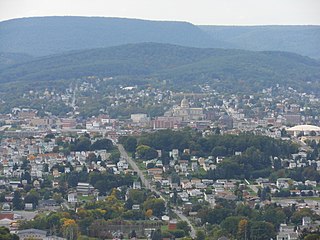
Altoona is a city in Blair County, Pennsylvania, United States. The population was 43,963 at the time of the 2020 census. It is the principal city of the Altoona metropolitan area, which includes all of Blair County and was recorded as having a population of 122,822 in 2020.

<span class="mw-page-title-main">Bellwood, Pennsylvania</span> Borough in Pennsylvania, United States

Bellwood is a borough in Blair County, Pennsylvania, United States. It is part of the Altoona, PA Metropolitan Statistical Area. The population was at 1,829 as of the 2020 census.

<span class="mw-page-title-main">Frankstown Township, Blair County, Pennsylvania</span> Township in Pennsylvania, United States

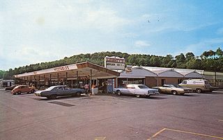
Frankstown Township is a township in Blair County, Pennsylvania, United States. It is part of the Altoona Metropolitan Statistical Area. The population was 7,399 at the 2020 census. The township was named after Stephen Franks, a pioneer citizen.

<span class="mw-page-title-main">Hollidaysburg, Pennsylvania</span> Place in Pennsylvania, United States

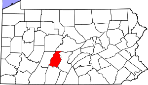
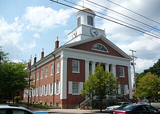
Hollidaysburg is a borough in and the county seat of Blair County in the U.S. Commonwealth of Pennsylvania. It is located on the Juniata River, 5 miles (8 km) south of Altoona and is part of the Altoona, Pennsylvania, metropolitan statistical area. In 1900, 2,998 people lived in the borough, in 1910, 3,734 lived there, and in 1940, 5,910 residents were counted. The population was 5,641 at the 2020 census. Coal, iron ore, ganister, and limestone are found in the vicinity. In the past, the borough had foundries and machine shops, a silk mill, car works and classification yards.

<span class="mw-page-title-main">Newry, Pennsylvania</span> Borough in Pennsylvania, United States

Newry is a borough in Blair County, Pennsylvania, United States. The population was 231 at the 2020 census. It is part of the Altoona, PA Metropolitan Statistical Area and one of the communities comprising the Altoona Urban Area.

<span class="mw-page-title-main">Williamsburg, Pennsylvania</span> Borough in Pennsylvania, United States

Williamsburg in Morrisons Cove, is a borough in Blair County, Pennsylvania, United States. The population was 1,241 at the 2020 census. It is part of the Altoona, PA Metropolitan Statistical Area.

<span class="mw-page-title-main">Frankstown Branch Juniata River</span>

The Frankstown Branch Juniata River is a 46.0-mile-long (74.0 km) tributary of the Juniata River in Blair and Huntingdon counties, Pennsylvania, in the United States.

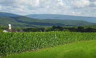
Morrisons Cove, is an eroded anticlinal valley in Blair and Bedford counties of central Pennsylvania, United States, extending from Evitts Mountain near New Enterprise, north to the Frankstown Branch Juniata River at Williamsburg. The width of the valley varies from 10 to 15 miles between Tussey Mountain on the east to the chain of Dunning, Loop and Lock Mountains on the west. Almost entirely enclosed by these mountains, the only openings in the cove are at Loysburg Gap in the south, McKee Gap in the west, and at Williamsburg to the north. The floor of the valley is mostly level, with many large fertile farm fields. The southern end of the valley drains to the Raystown Branch Juniata River via Yellow Creek through Loysburg Gap, and the northern end drains to the Frankstown Branch, via Clover Creek.

<span class="mw-page-title-main">Pennsylvania Route 164</span> State highway in Pennsylvania, US

Pennsylvania Route 164 is a 36-mile-long (58 km) state highway located in Cambria, Blair, and Bedford counties in Pennsylvania. The western terminus is at an interchange with U.S. Route 22 (US 22) in Munster Township. The eastern terminus is at PA 26 near Raystown Lake.

<span class="mw-page-title-main">Pennsylvania Route 866</span> State highway in Pennsylvania, US

Pennsylvania Route 866 is a 22.4-mile-long (36.0 km) state highway located in Bedford and Blair Counties in central Pennsylvania. The southern terminus is at PA 36 in Woodbury. The northern terminus is at U.S. Route 22 in Frankstown Township.

<span class="mw-page-title-main">Pennsylvania House of Representatives, District 80</span> American legislative district

The 80th Pennsylvania House of Representatives District is located in central Pennsylvania and has been represented by James V. Gregory since 2019.

<span class="mw-page-title-main">Hollidaysburg Area School District</span> School district in Pennsylvania

The Hollidaysburg Area School District is a midsized, suburban public school district which is based in Hollidaysburg, Pennsylvania. It serves the boroughs of Duncansville, Hollidaysburg, and Newry, and the townships of Allegheny, Blair, Frankstown, and Juniata.

The Pennsylvania State Game Lands Number 147 are Pennsylvania State Game Lands in Blair County in Pennsylvania in the United States providing hunting, trapping, bird watching, and other activities.

The Pennsylvania State Game Lands Number 166 are Pennsylvania State Game Lands in Blair and Huntingdon Counties in Pennsylvania in the United States providing hunting, trapping, bird watching, and other activities.

Fort Fetter is a neighborhood and census-designated place (CDP) in Blair County, Pennsylvania, United States. It was first listed as a CDP prior to the 2020 census.

References

  1. Includes Westmoreland, Cambria, Fayette, Blair, Indiana, Somerset, Bedford, Huntingdon, Greene and Fulton Counties
  1. "PHMC Historical Markers Search". Pennsylvania Historical and Museum Commission. Commonwealth of Pennsylvania. Archived from the original (Searchable database) on March 21, 2016. Retrieved January 25, 2014.
  2. "Census - Geography Profile: Blair County, Pennsylvania". United States Census Bureau . Retrieved April 24, 2022.
  3. "Find a County". National Association of Counties. Archived from the original on May 31, 2011. Retrieved June 7, 2011.
  4. "Combined Statistical Areas Map (March 2020)" (PDF). The United States Census Bureau. Archived (PDF) from the original on October 21, 2020. Retrieved August 11, 2021.
  5. "2010 Census Gazetteer Files". United States Census Bureau. August 22, 2012. Retrieved March 5, 2015.
  6. "Monthly Averages for Altoona, PA". psac.met.psu. 2009. Archived from the original on September 7, 2008. Retrieved July 5, 2009.
  7. "Census 2020".
  8. "U.S. Census website". United States Census Bureau . Retrieved January 31, 2008.
  9. "P2 HISPANIC OR LATINO, AND NOT HISPANIC OR LATINO BY RACE – 2020: DEC Redistricting Data (PL 94-171) – Blair County, Pennsylvania".
  10. Leip, David. "Dave Leip's Atlas of U.S. Presidential Elections". uselectionatlas.org. Retrieved November 21, 2018.
  11. Burnham, Walter Dean. "Presidential ballots, 1836-1892". archive.org. Retrieved January 16, 2021.
  12. Pennsylvania Department of State (February 5, 2024). "Voter registration statistics by county". dos.pa.gov. Retrieved February 7, 2024.
  13. "2010 U.S. Census website". United States Census Bureau . Retrieved February 13, 2016.

40°28′N78°21′W / 40.47°N 78.35°W / 40.47; -78.35