Falls Township, Bucks County, Pennsylvania

Last updated

Falls Township
Pennsbury Manor 01.JPG
Pennsbury Manor, a reproduction of William Penn's residence
Falls Township Seal.png
Bucks county - Falls Township.png
Location of Falls Township in Bucks County
USA Pennsylvania location map.svg
Red pog.svg
Falls Township
Location in Pennsylvania and the United States
Usa edcp location map.svg
Red pog.svg
Falls Township
Falls Township (the United States)
Coordinates: 40°10′36″N74°49′40″W / 40.17667°N 74.82778°W / 40.17667; -74.82778
CountryUnited States
StatePennsylvania
County Bucks
Established1692
Area
[1]
  Total26.58 sq mi (68.8 km2)
  Land21.33 sq mi (55.2 km2)
  Water5.25 sq mi (13.6 km2)
Elevation
69 ft (21 m)
Population
 (2010)
  Total34,300
  Estimate 
(2016) [2]
33,714
  Density1,300/sq mi (500/km2)
Time zone UTC-5 (EST)
  Summer (DST) UTC-4 (EDT)
Area codes 215, 267 and 445
FIPS code 42-017-25112
Website www.fallstwp.com

Falls Township is a suburban Philadelphia township in Bucks County, Pennsylvania, United States. The population was 34,300 at the 2010 census. Portions of Fairless Hills and Levittown, Pennsylvania, are located in the township. Portions of Falls Township are called Morrisville and Yardley, due to the location of the Morrisville Post Office outside the Borough of Morrisville in Falls Township. As originally chartered in 1692, the villages of Morrisville and Tullytown were part of Falls Township. Morrisville was granted borough status in 1804. Tullytown was established as a borough in 1891.

Contents

History

Dutch settlements here were established as early as 1616. A number of colonists came to Falls Township before William Penn founded Pennsylvania in 1681, including William Biles.

Fallsington is the only settlement of this period which has been in continuous use. Fallsington is an example of a crossroads village typical of the time. The Bucks County Courthouse, established in 1663[ citation needed ], is said to have been located in Fallsington until it was moved to Bristol in 1705. The Friends Meeting, whose first meetings were held at the home of William Biles on Biles Island, found a site for a brick meeting house, built about 1690 in Fallsington on 6 acres (0.024 km2) of land that had been donated by Samuel Burges. Also in 1690, Thomas Janney donated 72 acres (0.29 km2) of land to be used as the Quaker burial grounds for Falls Monthly Meeting. William Penn donated a tract of 120 acres (0.49 km2), for a Falls commons. The township itself was established in 1692. Numerous villages were located within the township, with Fallsington being the center of social and commercial activity in the township. Morrisville was another prominent village, until it was partitioned as a borough in 1804. Tullytown was also a village until it was partitioned as a borough in 1891.

Villages and other place names, past and present, include Dogtown, Fairless Hills, Fallsington, Kildorpy, Kirkbridesville, Levittown, Morningside, Oxford Valley (located in both Falls Township and Middletown Township, Penns Manor, Penn Valley, Slickville, Tyburn, and Wheatsheaf. [3]

The growth of Fallsington continued, with the construction of homes, an inn, public buildings, stores, and small craftsmen's shops. Until the construction of Fairless Hills and Levittown, it was the largest village in the township, and functioned for many years as a commercial center.

In 1682, William Penn began construction of his official residence, Pennsbury Manor. The 8,431-acre (34.12 km2) site in Falls Township was chosen for its easy access to Philadelphia along the Delaware River. This island was gradually sold by Penn's heirs and the last original building was destroyed in 1864. In 1932, a small portion of the original site was purchased by Pennsylvania and reconstruction of Pennsbury Manor was begun. Pennsbury is now a historical site, open to the public. It was listed on the National Register of Historic Places in 1969. [4]

The proximity of major transportation systems influenced much of the township's development. The earliest of these was the Delaware River. The township is located at the upper end of the navigable portion of the river. In 1686, the Provincial Council ordered the construction of the King's Highway, which ran from Philadelphia to Trenton along an existing Indian trail, through Bristol, Falls, and Morrisville. The King's Highway still exists today as U.S. Route 13, flowing closely the original configuration. Additional roads and turnpikes were built in the 18th and early 19th centuries.

Other transportation systems were laid out through Falls Township in the 19th and early 20th centuries. The Delaware Canal from Easton to Bristol was opened in 1832. A railroad line from Philadelphia to Trenton via Morrisville was built between 1833 and 1835. The rail line became part of Pennsylvania Railroad's main New York-Philadelphia line. The "West Trenton" cut-off of the Pennsylvania Railroad was built through the northern part of the township at the end of 19th century. These rail lines now accommodate SEPTA, Amtrak and Conrail passenger and freight between Philadelphia and Trenton.

Geography

According to the U.S. Census Bureau, the township has a total area of 26.6 square miles (69 km2), of which 22.3 square miles (58 km2) is land and 4.3 square miles (11 km2) (16.11%) is water. Natural features include Biles Island, Common Creek, Martins Creek, Mint Island, Queen Anne Creek, Scotts Creek, and Turkey Hill. [3] Falls Township contains the easternmost point of Pennsylvania's southern half.

Demographics

Historical population
CensusPop.Note
1890 2,463
1900 1,856−24.6%
1910 1,851−0.3%
1920 1,789−3.3%
1930 2,00412.0%
1940 2,36418.0%
1950 3,54049.7%
1960 29,082721.5%
1970 35,85023.3%
1980 36,0830.6%
1990 34,997−3.0%
2000 34,865−0.4%
2010 34,300−1.6%
2020 34,7161.2%
Source: [5] [6]

As of the 2010 census, the township was 84.1% Non-Hispanic White, 5.8% Black or African American, 0.2% Native American, 4.2% Asian, and 2.1% were two or more races. 4.4% of the population were of Hispanic or Latino ancestry [7]

As of the census [8] of 2000, there were 34,865 people, 13,170 households, and 9,403 families residing in the township. The population density was 1,565.0 inhabitants per square mile (604.2/km2). There were 13,528 housing units at an average density of 607.2 per square mile (234.4/km2). The racial makeup of the township was 90.22% White, 4.89% African American, 0.16% Native American, 2.58% Asian, 0.02% Pacific Islander, 0.77% from other races, and 1.37% from two or more races. Hispanic or Latino of any race were 2.35% of the population.

There were 13,170 households, out of which 35.1% had children under the age of 18 living with them, 54.5% were married couples living together, 12.1% had a female householder with no husband present, and 28.6% were non-families. 23.4% of all households were made up of individuals, and 9.0% had someone living alone who was 65 years of age or older. The average household size was 2.64 and the average family size was 3.15.

In the township the population was spread out, with 25.8% under the age of 18, 7.9% from 18 to 24, 31.8% from 25 to 44, 21.8% from 45 to 64, and 12.7% who were 65 years of age or older. The median age was 36 years. For every 100 females, there were 94.9 males. For every 100 females age 18 and over, there were 92.1 males.

The median income for a household in the township was $50,129, and the median income for a family was $57,033. Males had a median income of $41,200 versus $30,117 for females. The per capita income for the township was $22,376. About 3.7% of families and 5.5% of the population were below the poverty line, including 5.9% of those under age 18 and 4.8% of those age 65 or over.

Transportation

US 1 southbound at US 13 in Falls Township 2022-09-19 13 23 36 View south along U.S. Route 1 (Martin Luther King, Junior Expressway) from the overpass for U.S. Route 13 in Falls Township, Bucks County, Pennsylvania.jpg
US 1 southbound at US 13 in Falls Township

As of 2019 there were 131.48 miles (211.60 km) of public roads in Falls Township, of which 45.60 miles (73.39 km) were maintained by the Pennsylvania Department of Transportation (PennDOT) and 85.88 miles (138.21 km) were maintained by the township. [9]

U.S. Route 1 is the most prominent highway serving Falls Township, following a freeway along an east-west alignment across the northern portion of the township. U.S. Route 13 also follows a freeway through the township on a north-south alignment, terminating at US 1. U.S. Route 1 Business follows the Lincoln Highway to the south of US 1's routing in the northwestern section of the township. Pennsylvania Route 32 begins at the US 1 freeway in the northeastern section of the township, heading northeastward along Bridge Street.

SEPTA provides Suburban Bus service to Falls Township along Route 127, which runs between the Oxford Valley Mall and the Trenton Transit Center, and Route 128, which runs between the Neshaminy Mall and the Oxford Valley Mall. Amtrak's Northeast Corridor and SEPTA Regional Rail's Trenton Line pass through the township but do not have any stations within it. The nearest SEPTA Regional Rail stations are Levittown station and Trenton Transit Center, with the latter station also serving Amtrak and NJ Transit. [10]

Climate

According to the Köppen climate classification system, Falls Township has a Humid subtropical climate (Cfa). Cfa climates are characterized by all months having an average mean temperature > 32.0 °F (0.0 °C), at least four months with an average mean temperature ≥ 50.0 °F (10.0 °C), at least one month with an average mean temperature ≥ 71.6 °F (22.0 °C) and no significant precipitation difference between seasons. Although most summer days are slightly humid in Falls Township, episodes of heat and high humidity can occur with heat index values > 108 °F (42 °C). Since 1981, the highest air temperature was 103.4 °F (39.7 °C) on June 7, 2010, and the highest daily average mean dew point was 75.1 °F (23.9 °C) on August 13, 2016. The average wettest month is July which corresponds with the annual peak in thunderstorm activity. Since 1981, the wettest calendar day was 6.49 inches (165 mm) on August 27, 2011. During the winter months, the average annual extreme minimum air temperature is 1.6 °F (−16.9 °C). [11] Since 1981, the coldest air temperature was −10.2 °F (−23.4 °C) on January 22, 1984. Episodes of extreme cold and wind can occur with wind chill values < −9 °F (−23 °C). The average annual snowfall (Nov-Apr) is between 24 inches (61 cm) and 30 inches (76 cm). Ice storms and large snowstorms depositing ≥ 12 inches (30 cm) occur once every few years, particularly during nor’easters from December through February.

Climate data for Falls Twp, Elevation 13 ft (4 m), 1991-2020 normals, extremes 1981-2018
MonthJanFebMarAprMayJunJulAugSepOctNovDecYear
Record high °F (°C)71.8
(22.1)
78.1
(25.6)
87.9
(31.1)
95.1
(35.1)
95.8
(35.4)
97.2
(36.2)
103.4
(39.7)
101.1
(38.4)
98.7
(37.1)
89.3
(31.8)
81.4
(27.4)
76.1
(24.5)
103.4
(39.7)
Mean daily maximum °F (°C)41.0
(5.0)
43.8
(6.6)
51.8
(11.0)
64.0
(17.8)
73.3
(22.9)
82.7
(28.2)
86.9
(30.5)
85.2
(29.6)
78.3
(25.7)
67.1
(19.5)
56.1
(13.4)
45.1
(7.3)
64.7
(18.2)
Daily mean °F (°C)32.8
(0.4)
34.6
(1.4)
41.9
(5.5)
52.6
(11.4)
61.8
(16.6)
71.3
(21.8)
75.9
(24.4)
74.4
(23.6)
67.2
(19.6)
55.8
(13.2)
46.3
(7.9)
36.6
(2.6)
54.3
(12.4)
Mean daily minimum °F (°C)24.6
(−4.1)
25.4
(−3.7)
32.0
(0.0)
41.2
(5.1)
50.3
(10.2)
60.0
(15.6)
64.9
(18.3)
63.6
(17.6)
56.2
(13.4)
44.4
(6.9)
36.4
(2.4)
28.1
(−2.2)
43.9
(6.6)
Record low °F (°C)−10.2
(−23.4)
−2.6
(−19.2)
4.4
(−15.3)
18.0
(−7.8)
32.5
(0.3)
41.0
(5.0)
47.1
(8.4)
42.1
(5.6)
36.0
(2.2)
24.8
(−4.0)
11.3
(−11.5)
0.5
(−17.5)
−10.2
(−23.4)
Average precipitation inches (mm)3.54
(90)
2.77
(70)
4.30
(109)
3.91
(99)
4.09
(104)
4.32
(110)
5.20
(132)
4.23
(107)
4.27
(108)
3.67
(93)
3.48
(88)
4.00
(102)
47.78
(1,214)
Average relative humidity (%)65.161.758.057.062.166.166.468.669.868.566.966.864.8
Average dew point °F (°C)21.7
(−5.7)
22.8
(−5.1)
28.2
(−2.1)
37.8
(3.2)
48.7
(9.3)
59.4
(15.2)
63.9
(17.7)
63.4
(17.4)
57.0
(13.9)
45.6
(7.6)
35.9
(2.2)
26.6
(−3.0)
42.7
(5.9)
Source: PRISM [12]

Ecology

According to the A. W. Kuchler U.S. potential natural vegetation types, Falls Township would have a dominant vegetation type of Appalachian Oak (104) with a dominant vegetation form of Eastern Hardwood Forest (25). [13] The plant hardiness zone is 7a with an average annual extreme minimum air temperature of 1.6 °F (−16.9 °C). [11] The spring bloom typically begins by April 8 and fall color usually peaks by November 3.

Related Research Articles

<span class="mw-page-title-main">Bucks County, Pennsylvania</span> County in Pennsylvania, United States

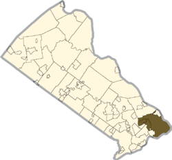
Bucks County is a county in the Commonwealth of Pennsylvania. As of the 2020 census, the population was 646,538, making it the fourth-most populous county in Pennsylvania. Its county seat is Doylestown. The county is named after the English county of Buckinghamshire. The county is part of the Southeast Pennsylvania region of the state.

<span class="mw-page-title-main">Bristol, Pennsylvania</span> Borough in Pennsylvania, United States

Bristol is a borough in Bucks County, Pennsylvania, United States. It is located 23 miles (37 km) northeast of Center City Philadelphia, opposite Burlington, New Jersey on the Delaware River.

<span class="mw-page-title-main">Bristol Township, Pennsylvania</span> Township in Pennsylvania, United States

Bristol Township is a township in Bucks County, Pennsylvania, United States. The population was 54,582 at the 2010 census, making it the 13th largest municipality in the state. Bristol Township, along with Bristol Borough, is a cultural hub for Lower Bucks County, hosting celebrations of African and Latino heritage. Parts of the township consist of the neighborhoods of Fairless Hills and Levittown. It is located within the Delaware Valley.

<span class="mw-page-title-main">Buckingham Township, Bucks County, Pennsylvania</span> Township in Pennsylvania, United States

Buckingham Township is a township in Bucks County, Pennsylvania, United States. The population was 20,075 at the 2010 census. Buckingham takes its name from Buckingham in Buckinghamshire, England. Buckingham Township was once known as Greenville and was once the historic county seat of the English Bucks County.

<span class="mw-page-title-main">Langhorne, Pennsylvania</span> Borough in Pennsylvania, United States

Langhorne Borough is a borough in Bucks County, Pennsylvania, United States. The population was 1,622 at the time of the 2010 census.

<span class="mw-page-title-main">Langhorne Manor, Pennsylvania</span> Borough in Pennsylvania, United States

Langhorne Manor is a borough in Bucks County, Pennsylvania, United States. The population was 1,422 at the 2010 census, a 55.6% increase from the 2000 census. The mayor of Langhorne Manor is Bob Byrne.

<span class="mw-page-title-main">Levittown, Pennsylvania</span> Census-designated place and planned community in Pennsylvania, US

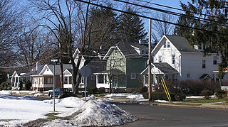
Levittown is a census-designated place (CDP) and planned community in Bucks County, Pennsylvania, United States. It is part of the Philadelphia metropolitan area. The population was 52,699 at the 2020 census, down from 52,983 at the 2010 census.

<span class="mw-page-title-main">Lower Makefield Township, Pennsylvania</span> Township in Pennsylvania, United States

Lower Makefield Township is a township in Bucks County, Pennsylvania, United States. Lower Makefield Township is located in the Delaware Valley and borders the Delaware River and New Jersey to its north and east. Most addresses in the township have a Yardley address; the township surrounds the borough of Yardley on its north, south, and west.

<span class="mw-page-title-main">Lower Southampton Township, Pennsylvania</span> Township in Pennsylvania, United States

Lower Southampton Township is a township in Bucks County, Pennsylvania, United States. The population was 20,599 at the 2020 census.

<span class="mw-page-title-main">Middletown Township, Bucks County, Pennsylvania</span> Place in Pennsylvania, United States

Middletown Township is a township in Bucks County, Pennsylvania, United States. The population was 46,040 at the 2020 census. Many sections of Levittown are located in the southern end of the township. The municipality surrounds the boroughs of Langhorne, Langhorne Manor, Penndel and Hulmeville; much of the township beyond Levittown uses Langhorne as its mailing address. The township is located within the Delaware Valley, also known as the Philadelphia metropolitan area.

<span class="mw-page-title-main">Morrisville, Bucks County, Pennsylvania</span> Borough in Pennsylvania, United States

Morrisville is a borough in Bucks County, Pennsylvania, United States. It is located just below the falls of the Delaware River opposite Trenton, New Jersey. The population was 9,809 in the 2020 Census.

<span class="mw-page-title-main">Newtown, Bucks County, Pennsylvania</span> Borough in Pennsylvania, United States

Newtown is a borough in Bucks County, Pennsylvania, United States. The population was 2,268 at the 2020 census. It is located just west of the Trenton, New Jersey metropolitan area, and is part of the larger Philadelphia metropolitan area. It is entirely surrounded by Newtown Township, from which it separated in 1838. State Street is the main commercial thoroughfare with wide sidewalks, shops, taverns, and restaurants.

<span class="mw-page-title-main">Northampton Township, Bucks County, Pennsylvania</span> Township in Pennsylvania, United States

Northampton Township is a township in Bucks County, Pennsylvania, United States. The township is located approximately 12 miles northeast of Philadelphia. The population was 39,915 at the 2020 census.

<span class="mw-page-title-main">Penndel, Pennsylvania</span> Borough in Pennsylvania, United States

Penndel is a borough in Bucks County, Pennsylvania, United States. The population was 2,328 at the 2010 census.

<span class="mw-page-title-main">Tullytown, Pennsylvania</span> Borough in Pennsylvania, United States

Tullytown is a borough in Bucks County, Pennsylvania, United States. Originally a village in Falls Township, Tullytown was partitioned as a borough in 1891. The population was 1,872 at the 2010 census. Part of Levittown is located in Tullytown.

<span class="mw-page-title-main">Upper Southampton Township, Pennsylvania</span> Township in Pennsylvania, United States

Upper Southampton Township is a township in Bucks County, Pennsylvania, United States. The population was 15,152 at the 2010 census.

<span class="mw-page-title-main">Yardley, Pennsylvania</span> Borough in Pennsylvania, United States

Yardley is a borough in Bucks County, Pennsylvania, United States. Yardley borders the Delaware River and Ewing, New Jersey to its east and Lower Makefield Township to its north, west, and south. The United States Post Office assigns many addresses in Lower Makefield Township the preferred city of "Yardley", although they are outside the borough. The population was 2,434 at the 2010 census. Yardley is part of the Delaware Valley metropolitan area.

<span class="mw-page-title-main">U.S. Route 1 in Pennsylvania</span> Highway in Pennsylvania

U.S. Route 1 (US 1) is a major north–south U.S. Route, extending from Key West, Florida, in the south to Fort Kent, Maine, at the Canada–United States border in the north. In the U.S. state of Pennsylvania, US 1 runs for 81 miles (130 km) from the Maryland state line near Nottingham northeast to the New Jersey state line at the Delaware River in Morrisville, through the southeastern portion of the state. The route runs southwest to northeast and serves as a major arterial road through the city of Philadelphia and for many of the suburbs in the Delaware Valley metropolitan area. South of Philadelphia, the road mostly follows the alignment of the Baltimore Pike. Within Philadelphia, it mostly follows Roosevelt Boulevard. North of Philadelphia, US 1 parallels the route of the Lincoln Highway. Several portions of US 1 in Pennsylvania are freeways, including from near the Maryland state line to Kennett Square, the bypass of Media, the concurrency with Interstate 76 and the Roosevelt Expressway in Philadelphia, and between Bensalem Township and the New Jersey state line.

<span class="mw-page-title-main">U.S. Route 13 in Pennsylvania</span> Highway in Pennsylvania

U.S. Route 13 (US 13) is a United States Numbered Highway running from Fayetteville, North Carolina, north to Morrisville, Pennsylvania. The route runs for 49.359 miles (79.436 km) through the Delaware Valley in the U.S. state of Pennsylvania. The route enters the state from Delaware in Marcus Hook, Delaware County. It continues northeast through Delaware County, passing through the city of Chester before heading through suburban areas along Chester Pike to Darby. US 13 enters the city of Philadelphia on Baltimore Avenue and runs through West Philadelphia to University City, where it turns north along several city streets before heading east across the Schuylkill River along Girard Avenue. The route turns north and heads to North Philadelphia, where it runs northeast along Hunting Park Avenue. US 13 becomes concurrent with US 1 on Roosevelt Boulevard, continuing into Northeast Philadelphia. US 13 splits southeast on a one-way pair of streets before heading northeast out of the city on Frankford Avenue. The route continues into Bucks County as Bristol Pike, heading northeast to Bristol, where it turns into a divided highway. US 13 becomes a freeway in Tullytown and continues north to its terminus at US 1 in Falls Township, near Morrisville. US 13 roughly parallels Interstate 95 (I-95) through its course in Pennsylvania.

<span class="mw-page-title-main">Fallsington, Pennsylvania</span> Unincorporated community in Pennsylvania, United States

Fallsington is an unincorporated community in Falls Township, Bucks County, Pennsylvania, United States.

References

  1. "2016 U.S. Gazetteer Files". United States Census Bureau. Retrieved August 13, 2017.
  2. "Population and Housing Unit Estimates" . Retrieved June 9, 2017.
  3. 1 2 MacReynolds, George, Place Names in Bucks County, Pennsylvania, Doylestown, Bucks County Historical Society, Doylestown, PA, 1942, P1. - Falls Township
  4. "National Register Information System". National Register of Historic Places . National Park Service. July 9, 2010.
  5. "Census of Population and Housing". U.S. Census Bureau.
  6. "Census 2020".
  7. "Census 2010: Pennsylvania". USA Today. Retrieved July 19, 2011.
  8. "U.S. Census website". United States Census Bureau . Retrieved January 31, 2008.
  9. "Falls Township map" (PDF). PennDOT. Retrieved March 11, 2023.
  10. SEPTA Official Transit & Street Map Suburban (PDF) (Map). SEPTA. Retrieved May 2, 2016.
  11. 1 2 "USDA Interactive Plant Hardiness Map". United States Department of Agriculture. Archived from the original on July 4, 2019. Retrieved October 22, 2019.
  12. "PRISM Climate Group, Oregon State University" . Retrieved October 22, 2019.
  13. "U.S. Potential Natural Vegetation, Original Kuchler Types, v2.0 (Spatially Adjusted to Correct Geometric Distortions)" . Retrieved October 22, 2019.