Armstrong County, Pennsylvania

Last updated

Armstrong County
Kittanning, Pennsylvania (8482749220).jpg
Armstrong County Courthouse
Seal of Armstrong County, Pennsylvania.png
Map of Pennsylvania highlighting Armstrong County.svg
Location within the U.S. state of Pennsylvania
Pennsylvania in United States.svg
Pennsylvania's location within the U.S.
Coordinates: 40°49′N79°28′W / 40.81°N 79.46°W / 40.81; -79.46
CountryFlag of the United States.svg United States
StateFlag of Pennsylvania.svg  Pennsylvania
FoundedMarch 12, 1800
Named for John Armstrong
Seat Kittanning
Largest boroughKittanning
Area
  Total664 sq mi (1,720 km2)
  Land653 sq mi (1,690 km2)
  Water11 sq mi (30 km2)  1.6%
Population
 (2020)
  Total65,558
  Density100/sq mi (40/km2)
Time zone UTC−5 (Eastern)
  Summer (DST) UTC−4 (EDT)
Congressional district 15th
Website www.co.armstrong.pa.us
DesignatedOctober 15, 1982 [1]

Armstrong County is a county in the Commonwealth of Pennsylvania. As of the 2020 census, the population was 65,558. [2] The county seat is Kittanning. [3] The county was organized on March 12, 1800, from parts of Allegheny, Westmoreland and Lycoming Counties. It was named in honor of John Armstrong, who represented Pennsylvania in the Continental Congress and served as a major general during the Revolutionary War.

Contents

The county is part of the Greater Pittsburgh region of the state. [lower-alpha 1]

History

Pre-settlement

Crooked Creek Lake Recreation Area, a dam, reservoir, and park near Ford City in Armstrong County USACE Crooked Creek Lake and Dam.jpg
Crooked Creek Lake Recreation Area, a dam, reservoir, and park near Ford City in Armstrong County

Little is known of the pre-Columbian history of the area that is today called Armstrong County, but the often cited starting point begins with the civilization known colloquially as the Mound Builders.

Several 19th-20th century farmers throughout the county have unearthed artifacts from this time period, such as arrowheads. Several of the prominent earthen works characteristic of this culture have been removed for agricultural and settlement purposes. One prominent mound was located between present-day Kittanning and Ford City and was believed to have been an earthen fortification used to defend against other tribal peoples. Other mounds were found in Boggs, South Buffalo, and Washington townships. The aboriginal inhabitants were given the name "Allegewi" by the tribes that drove them out sometime between the 15th and 17th centuries.

Historical accounts describe the tribes that conquered the Allegewi as primarily the Lenape or "Delaware" tribes, along with bands of Mohawk, Oneidas, Cayugas, Onondagas, and Seneca tribes. The Lenape tribe made semi-permanent and permanent settlements in and around present-day Kittanning, and much of the area functioned as their hunting and agricultural lands. Blockhouses built by the Lenape, not unlike the early European settler dwellings, were commonly seen around Ford City, Kittanning, South Buffalo, Brady's Bend, and Red Bank. The Lenape were the primary inhabitants of the area and were the primary points of contact for European settlers in this area at the turn of the 18th century.

18th century

With the arrival of European settlers also came the competing claims to the territory, primarily between the French and British empires, who were engaged in what became known as the Seven Years' War. As the global conflict between the two empires expanded into the "New World," both sides attempted to court the many Native American tribes. Several tribes in the Allegheny River Valley, including the Lenni-Lenape, sided with the French during this time period, as their friendship appeared to be more advantageous to their own territorial claims against the British-friendly Iroquois Nations.

In exchange for furs, freedom of movement in Lenape territory, and guerilla raids on British troops and settlers, the French supplied weapons and other European goods and offered military protection to the friendly tribes. This agreement and similar alliances with other tribes allowed the French to become more well dug-in along the Allegheny River, most prominently at Fort Duquesne in present-day Pittsburgh. Several military engagements in the Ohio Country, which would later become Western Pennsylvania, were part of the French and Indian War.

One of the minor battles that erupted during the French and Indian War occurred at the present site of the Armstrong County seat, Kittanning, or Kit-hane-ink, as it was referred to by the Lenape, meaning "settlement by the main river." Although the Battle of Kittanning was inconsequential to the greater conflict with the French and Indian tribes, it is an integral part of Armstrong County's history. The expedition, led by Lieutenant Colonel John Armstrong, brought about the destruction of the Lenape village of Kittanning, which had served as a staging point for attacks by Lenape (Delaware) warriors against colonists in the colonial-era Province of Pennsylvania. Deep into hostile territory, the raid on Kittanning was the only major expedition carried out by Pennsylvania Provincial troops during the brutal backcountry war. It is often thought of by local historians as a type of pre-World War II Doolittle Raid.

With the surrender of George Washington at Fort Necessity in 1754 and Braddock's defeat in 1755, the settlers on the Pennsylvania frontier were without professional military protection, and scrambled to organize a defense. The French-allied Indians who had defeated General Edward Braddock at the Monongahela River were primarily from the Great Lakes region to the north. The local Indians, mostly Lenape and Shawnee who had migrated to the area after European colonists had settled their lands to the east, had waited to see who would win the contest—they could not risk siding with the loser. With Fort Duquesne now secured, the victorious French encouraged the Lenape and Shawnee to "take up the hatchet" against those who had taken their land.

Beginning about October 1755, Lenape and Shawnee war parties, often with French cooperation, began raiding settlements in Pennsylvania. Although European-Americans also waged war with cruelty, they found Indian warfare particularly brutal and frightening. Notable among the Indian raiders were the Lenape war leaders Shingas and Captain Jacobs, both of whom lived at Kittanning. The colonial governments of Pennsylvania and Virginia offered rewards for their scalps. Captain Jacobs was on an expedition led by Louis Coulon de Villiers that descended on Fort Granville (near present-day Lewistown) on the morning of August 2, 1756. The attackers were held off, but the garrison commander was killed, and his second in command surrendered the garrison, including the women and children, the next morning. The commander's brother, Lieutenant Colonel John Armstrong, immediately organized an expedition of 300 men against Kittanning in response. Early on September 8, 1756, they launched a surprise attack on the Indian village. Many of the Kittanning residents fled, but Captain Jacobs put up a defense, holing up with his wife and family inside their home. When he refused to surrender, his house and others were set on fire, touching off gunpowder that had been stored inside. Captain Jacobs was killed and scalped after jumping from his home in an attempt to escape the flames. The battle ended when the entire village was engulfed in flames.

The destruction of Kittanning was hailed as a victory in Pennsylvania, and Armstrong was known afterwards as the "Hero of Kittanning". He and his men collected the "scalp bounty" that had been placed on Captain Jacobs. However, the victory had limitations: the attackers suffered more casualties than they inflicted, and most of the villagers escaped, taking with them almost all of the prisoners that had been held in the village. The expedition also probably aggravated the frontier war; subsequent Indian raids that autumn were fiercer than ever. The Kittanning raid revealed to the village's inhabitants their vulnerability, and many moved to more secure areas. A peace faction led by Shingas's brother Tamaqua soon came to the forefront. Tamaqua eventually made peace with Pennsylvania in the Treaty of Easton, which enabled the British under General John Forbes to successfully mount an expedition in 1758 that drove the French from Fort Duquesne. Reenactments of the Battle of Kittanning have become a favorite pastime of the local inhabitants of present-day Armstrong County.

John Armstrong later served as a brigadier general in the Continental Army and as a major general in the Pennsylvania Militia during the Revolutionary War. He was also a delegate to the Continental Congress for Pennsylvania. Armstrong County, formed on March 12, 1800, from parts of Allegheny, Westmoreland and Lycoming Counties was named in the general's honor.

19th century

In the early 1800s, most people in Armstrong County were "old stock Americans" of Scotch-Irish and English ancestry, whose ancestors had settled in the area prior to the American Revolution. In the decades following the American Civil War, and in particular between 1890 and 1910, immigrants arrived in large numbers from Germany, Italy, Ireland, and Poland. [4]

As the county seat, Kittanning became the governmental, financial, and commercial hub for the county.

In the 1890s, Water Street (sometimes called "Millionaire Row") in Kittanning boasted more millionaire residents than anywhere else in Pennsylvania. Booming industries in the county such as coal, natural gas, plate glass, brick, ceramics, and iron created a strong local economy. Gradual population decline, via economic downturns, began in the 1970s and 1980s, and while there are still many coal mines and natural gas wells in operation throughout the county, the decline of the fossil fuel industry has severely limited the economy of Kittanning . Recently, revitalization efforts have led to a beautification of Market Street in Kittanning in an effort to attract new businesses and people.

Three miles upriver from Kittanning is Ford City. Incorporated in 1887, Ford City was a company town for John Baptiste Ford's renowned plate-glass industry, known now as Pittsburgh Plate Glass PPG Industries, a Fortune 500 Company. Eljer also operated a production facility along the river in Ford City that made ceramic toilets. The two companies employed nearly 10,000 people at the height of Armstrong County's economy.

In 1869, Leechburg was the first place in the United States to use natural gas for metallurgical purposes. Natural gas was found while drilling for oil, and eventually introduced into the boilers and furnaces of Siberian Iron Works.

Freeport, Leechburg, and Apollo were communities built along the Pennsylvania Canal, which passed through on the Allegheny and Kiskiminetas rivers, at the southern border of the county.

20th century

In the 20th century, Ford City struggled economically, but kept its economy and heritage alive through creative businesses and lively festivals.

21st century

Ford City is the future site of the Armstrong campus of Butler County Community College (BC3) - consistently ranked among the best community colleges in Pennsylvania. [5]

Armstrong County is home to the City of Parker, an incorporated third-class city, which was an oil boom town with a population rumored to be approximately 20,000 in 1873, but now is the "Smallest City in America" with a population of just under 800. Parker is located in the extreme northwest portion of the county.

Iron was made in the Brady's Bend area of the county twenty years before there was a foundry in Pittsburgh doing so.

Elderton, whose name is derived from the famous resident of the area, Sara Elder, is a small community, home to the former Elderton Jr/Sr High School.

Worthington is the county's primary agricultural hub and lies just west of Kittanning along Pennsylvania Route 422.

Geography

According to the U.S. Census Bureau, the county has a total area of 664 square miles (1,720 km2), of which 653 square miles (1,690 km2) is land and 11 square miles (28 km2) (1.6%) is water. [6]

Streams

The Allegheny and Kiskiminetas rivers; Buffalo, Crooked, Cowanshannock, Redbank, and Mahoning creeks; and Carnahan Run, among others, have watersheds within the county. The Murphy, Nicholson, Ross, and Cogley islands are in the Allegheny in Armstrong County.

Scrubgrass Creek

Scrubgrass Creek arises in Wayne Township and flows through Boggs Township, passing Goheenville, to Pine Township where it empties into the Mahoning Creek at Mahoning Station.

Sugar Creek

Sugar Creek flows through Bradys Bend Township where it empties into the Allegheny River. Its tributaries include Cove Run, Hart Run, Holder Run, Long Run, Pine Run, and Whiskey Run.

Adjacent counties

Major highways

Climate

Armstrong has a humid continental climate (Dfa/Dfb). Average monthly temperatures in Kittanning range from 27.3 °F in January to 72.6 °F in July. [7]

Demographics

Historical population
CensusPop.Note
1800 2,399
1810 6,143156.1%
1820 10,32468.1%
1830 17,70171.5%
1840 28,36560.2%
1850 29,5604.2%
1860 35,79721.1%
1870 43,38221.2%
1880 47,6419.8%
1890 46,747−1.9%
1900 52,55112.4%
1910 67,88029.2%
1920 75,56811.3%
1930 79,2984.9%
1940 81,0872.3%
1950 80,842−0.3%
1960 79,524−1.6%
1970 75,590−4.9%
1980 77,7682.9%
1990 73,478−5.5%
2000 72,392−1.5%
2010 68,941−4.8%
2020 65,558−4.9%
2022 (est.)64,747−1.2%
U.S. Decennial Census [8]
1790-1960 [9] 1900-1990 [10]
1990-2000 [11] 2010-2017 [12]

As of the census [13] of 2000, there were 72,392 people, 29,005 households, and 20,535 families residing in the county. The population density was 111 people per square mile (43 people/km2). There were 32,387 housing units at an average density of 50 per square mile (19/km2). The racial makeup of the county was 98.32% White, 0.82% Black or African American, 0.09% Native American, 0.12% Asian, 0.02% Pacific Islander, 0.13% from other races, and 0.50% from two or more races. 0.43% of the population were Hispanic or Latino of any race. 34.6% were of German, 10.8% Italian, 9.3% Irish, 8.7% American, 7.4% English and 5.7% Polish ancestry.

There were 29,005 households, out of which 29.50% had children under the age of 18 living with them, 57.90% were married couples living together, 9.00% had a female householder with no husband present, and 29.20% were non-families. 25.90% of all households were made up of individuals, and 13.70% had someone living alone who was 65 years of age or older. The average household size was 2.46 and the average family size was 2.95.

The distribution of the age of the population in the county was 22.90% under the age of 18, 7.20% from 18 to 24, 27.60% from 25 to 44, 24.20% from 45 to 64, and 18.00% who were 65 years of age or older. The median age was 40 years. For every 100 females, there were 94.70 males. For every 100 females age 18 and over, there were 92.10 males.

2020 census

Armstrong County Racial Composition [14]
RaceNum.Perc.
White (NH)62,32095%
Black or African American (NH)4380.67%
Native American (NH)570.1%
Asian (NH)1470.22%
Pacific Islander (NH)140.02%
Other/Mixed (NH)2,0923.2%
Hispanic or Latino 4900.75%

Government and politics

United States presidential election results for Armstrong County, Pennsylvania [15]
Year Republican Democratic Third party
No.%No.%No.%
2020 27,48975.47%8,45723.22%4801.32%
2016 23,48473.70%7,17822.53%1,2023.77%
2012 20,14267.77%9,04530.43%5341.80%
2008 18,54261.27%11,13836.80%5831.93%
2004 18,92560.86%12,02538.67%1470.47%
2000 15,50856.55%11,12740.58%7882.87%
1996 11,05242.87%11,13043.17%3,59713.95%
1992 9,12232.20%12,99545.87%6,21621.94%
1988 11,50944.81%13,89254.09%2821.10%
1984 13,70948.37%14,52551.25%1100.39%
1980 12,95547.80%12,71846.92%1,4315.28%
1976 13,37846.05%15,17952.25%4931.70%
1972 17,55761.61%10,49036.81%4511.58%
1968 14,13246.56%13,92145.86%2,3007.58%
1964 10,61833.40%21,09866.37%740.23%
1960 19,88357.23%14,79942.59%630.18%
1956 20,05561.22%12,67138.68%340.10%
1952 16,95555.90%13,22143.59%1530.50%
1948 11,71253.45%9,90045.18%3001.37%
1944 13,65656.94%10,20242.54%1260.53%
1940 14,52454.30%12,14445.40%820.31%
1936 14,19846.65%15,95552.42%2810.92%
1932 10,88452.10%9,23044.18%7763.71%
1928 17,62577.86%4,82421.31%1870.83%
1924 11,19264.18%2,93116.81%3,31619.01%
1920 8,99569.23%3,26225.11%7355.66%
1916 6,02458.51%3,59034.87%6826.62%
1912 1,90418.91%3,02730.06%5,13951.03%
1908 6,11059.67%3,21231.37%9178.96%
1904 5,79867.94%2,27026.60%4665.46%
1900 6,44363.58%3,43833.93%2522.49%
1896 6,32561.12%3,82536.96%1991.92%
1892 4,70955.60%3,51241.46%2492.94%
1888 5,03055.89%3,76341.81%2072.30%

Voter registration

As of 25 September 2023, there were 40,716 registered voters in the county. The Republican Party accounts for a majority of the voters. There were 25,058 registered Republicans, 11,131 registered Democrats, 2,968 unaffiliated voters and 1,559 voters registered to other parties. [16]

Chart of Voter Registration

   Republican (61.54%)
   Democratic (27.34%)
   Independent (7.29%)
   Third Party (3.83%)
Voter registration and party enrollment
PartyNumber of votersPercentage
Republican 25,05861.54%
Democratic 11,13127.34%
Independent 2,9687.29%
Third Party 1,5593.83%
Total40,716100%

County government

County Commissioners:

District Attorney:

Sheriff:

Coroner:

Controller:

Treasurer:

Register of Wills and Recorder of Deeds:

Prothonotary and Clerk of Courts:

Judges:

State senate

State House Of Representatives

United States House of Representatives

Education

Map of Armstrong County, Pennsylvania Public School Districts Map of Armstrong County Pennsylvania School Districts.png
Map of Armstrong County, Pennsylvania Public School Districts

Colleges and universities

Public school districts

Technology school

Private schools

As reported by the Pennsylvania Department of Education - EdNA. April 2012.

Libraries

There are six public libraries in Armstrong County: [17] [18]

Communities

Map of Armstrong County, Pennsylvania with municipal labels showing cities and boroughs (in red), townships (in white), and census-designated places (in blue) Map of Armstrong County Pennsylvania With Municipal and Township Labels.png
Map of Armstrong County, Pennsylvania with municipal labels showing cities and boroughs (in red), townships (in white), and census-designated places (in blue)

Under Pennsylvania law, there are four types of incorporated municipalities: cities, boroughs, townships, and, in at most two cases, towns. The following cities, boroughs and townships are located in Armstrong County:

City

Boroughs

Townships

Census-designated places

Census-designated places are geographical areas designated by the U.S. Census Bureau for the purposes of compiling demographic data. They are not actual jurisdictions under Pennsylvania law. Other unincorporated communities, such as villages, may be listed here as well.

Unincorporated community

Former communities

Population ranking

The population ranking of the following table is based on the 2010 census of Armstrong County. [19]

county seat

RankCity/Town/etc.Population (2010 Census)Municipal typeIncorporated
1Kittanning 4,044Borough1803
2 Ford City 2,991Borough1889
3 Leechburg 2,156Borough1850
4 Orchard Hills 1,952CDP
5 Freeport 1,813Borough1833
6 Apollo 1,647Borough1848
7 North Apollo 1,297Borough
8 West Hills 1,263CDP
9 West Kittanning 1,175Borough1900
10 Lenape Heights 1,167CDP
11 Rural Valley 876Borough
12 Parker 840City1873
13 Pleasant View 780CDP
14 Worthington 639Borough1855
15 Dayton 553Borough1873
16 South Bethlehem 481Borough
17 North Vandergrift 447CDP
18 Manorville 410Borough
19 Ford Cliff 371Borough1922
20 Elderton 356Borough1859
21 Templeton 325CDP
22 Applewold 310Borough1899
23 Kiskimere 136CDP
24 Atwood 107Borough1884

Notable people

Politics

John Armstrong Sr. - namesake of Armstrong County, civil engineer, American military general, Battle of Kittanning

William F. Johnston - Armstrong County Bar Association, abolitionist, 11th Governor of Pennsylvania 1848–1852, namesake of Johnston Ave. in Kittanning

Joseph Buffington - Judge, US Court of Appeals for the Third Circuit, US Circuit Courts for the Third Circuit, and US District Judge of the United States District Court for the Western District of Pennsylvania

John R. Phillips, Leechburg native, U.S. Ambassador to Italy

Andrew Jackson Faulk - born in Kittanning, third Governor of the Dakota Territory

George L. Shoup, First governor of Idaho, United States senator

US Congress: Samuel S. Harrison, Joseph Buffington Sr., Darwin Phelps, David Barclay, Joseph Grant Beale Daniel Brodhead Heiner, Jason Altmire

PA State Senators: Eben Kelley, Donald C. White, Albert Pechan

PA State Legislature: John S. Rhey, J. Alexander Fulton, John K. Calhoun, Franklin Mechling, Samuel B. Cochran, Timothy Pesci, Jeff Pyle, Abby Major

PA Supreme Court: James Thompson

John Gilpin - PA Constitutional Convention of 1873; namesake for Gilpin Township

John F. Hunter, Ohio state legislature

Military

Donald R. Lobaugh, Freeport native, U.S. Army soldier and Medal of Honor recipient in World War II

Raymond Harvey, Ford City native, Medal of Honor recipient in Korean War

Science

David Alter - Freeport, PA medical doctor; scientist; inventor of spectrum analysis, the idea that every element has its own emission spectrum: a breakthrough development in spectroscopy. The published article was: On Certain Physical Properties of Light Produced by the Combustion of Different Metals in an Electric Spark Refracted by a Prism published 1854

Sports

Ed Hobaugh - Kittanning native, MLB baseball player from Kittanning; right-hand pitcher for Washington Senators 1961-63

Mickey Morandini, Leechburg an MLB second baseman and coach, who played for the Philadelphia Phillies, Chicago Cubs, and Toronto Blue Jays. His career highlights include selection as a 1995 National League (NL) All-Star, playing for the Phillies in the 1993 NL Championship Series and World Series, and appearing for the Cubs in the 1998 NL Division Series. Also played for USA baseball in the 1988 Olympic Games is Seoul.

Dick Starr, major league pitcher, 1947–1951, New York Yankees, Washington Senators

Red Bowser, Freeport native, outfielder in Major League Baseball

Broc Hepler - Kittanning native, professional motorcross racing

Ryan Hemphill, Apollo native, NASCAR driver

Alex Kroll, professional football player for New York Titans (later Jets) and CEO of Young & Rubicam

Jack Lambert - American Football 4-time Super Bowl champion All-Pro linebacker for the Pittsburgh Steelers

Eric Ravotti, former NFL (Steeler) linebacker

Mitch Frerotte - an American professional football player who played as a guard for four seasons with the Buffalo Bills.

Gus Frerotte - former American football quarterback. He was drafted by the Washington Redskins in the seventh round of the 1994 NFL Draft. He played college football at Tulsa.

Bud Carson, former NFL coach, Steelers Defensive Coordinator for first two Super Bowl wins, helped develop the "Steel Curtain"

Greg Christy, played at Freeport High School, American football player, Buffalo Bills

Jeff Christy, played at Freeport High School, American football player, center for the Arizona Cardinals, the Minnesota Vikings, and the Tampa Bay Buccaneers from 1992 to 2003

Nick Bowers, NFL tight end for the Las Vegas Raiders, Kittanning native

Tim Levcik, American football player

Zigmund "Red" Mihalik, Hall of Fame basketball official

Other

Teri Hope, actress

Ralph Patt, jazz guitarist

Don Taylor, actor and director

Nellie Bly, Apollo native, journalist and adventurer, widely known for her record-breaking trip around the world in 72 days and investigative journalism

David Coulter, banker

See also

Related Research Articles

<span class="mw-page-title-main">Allegheny River</span> River in Pennsylvania and New York, United States

The Allegheny River is a 325-mile-long (523 km) headwater stream of the Ohio River that is located in western Pennsylvania and New York in the United States. It runs from its headwaters just below the middle of Pennsylvania's northern border, northwesterly into New York, then in a zigzag southwesterly across the border and through Western Pennsylvania to join the Monongahela River at the Forks of the Ohio at Point State Park in Downtown Pittsburgh, Pennsylvania.

<span class="mw-page-title-main">Allegheny County, Pennsylvania</span> County in Pennsylvania, United States

Allegheny County is a county in Pennsylvania, United States. As of the 2020 census, the population was 1,250,578, making it the state's second-most populous county, after Philadelphia County. Its county seat and most populous city is Pittsburgh, Pennsylvania's second most populous city. The county is part of the Greater Pittsburgh region of the state, and is the center of the Pittsburgh media market.

<span class="mw-page-title-main">Westmoreland County, Pennsylvania</span> County in Pennsylvania, United States

Westmoreland County is a county in the Commonwealth of Pennsylvania, United States, located in the Pittsburgh Metropolitan Statistical Area. As of the 2020 census, the population was 354,663. The county seat is Greensburg and the most populous community is Hempfield Township. It is named after Westmorland, a historic county of England. The county is part of the Southwest Pennsylvania region of the state.

<span class="mw-page-title-main">Jefferson County, Pennsylvania</span> County in Pennsylvania, United States

Jefferson County is a county in the Commonwealth of Pennsylvania. As of the 2020 census, the population was 44,492. Its county seat is Brookville. The county was established on March 26, 1804, from part of Lycoming County and later organized in 1830. It is named for President Thomas Jefferson. It is home to Punxsutawney Phil, the most famous groundhog that predicts when spring will come every February 2 on Groundhog Day. The county is part of the North Central Pennsylvania region of the state.

<span class="mw-page-title-main">Indiana County, Pennsylvania</span> County in Pennsylvania, United States

Indiana County is a county in the Commonwealth of Pennsylvania. It is located in the west central part of Pennsylvania. As of the 2020 census, the population was 83,246. Its county seat is Indiana. Indiana County comprises the Indiana, PA Micropolitan Statistical Area, which is also included in the Pittsburgh-New Castle-Weirton, PA-WV-OH Combined Statistical Area. The county is part of the Southwest Pennsylvania region of the state.

<span class="mw-page-title-main">Clarion County, Pennsylvania</span> County in Pennsylvania, United States

Clarion County is a county in the Commonwealth of Pennsylvania. As of the 2020 census, the population was 37,241. Its county seat is Clarion. The county was formed on March 11, 1839, from parts of Venango and Armstrong counties. Clarion County is entirely defined as part of the Pittsburgh media market. The county is part of the North Central Pennsylvania region of the state.

<span class="mw-page-title-main">Ford City, Pennsylvania</span> Borough in Pennsylvania, United States

Ford City is a borough in Armstrong County, Pennsylvania, United States, 40 miles (64 km) northeast of Pittsburgh along the east bank of the Allegheny River and 4 miles (6 km) south of Kittanning, the county seat. The population was 2,859 at the 2020 census. It is part of the Pittsburgh metropolitan area.

<span class="mw-page-title-main">Freeport, Pennsylvania</span> Borough in Pennsylvania, United States

Freeport is a borough in Armstrong County, Pennsylvania, United States. It is situated along the Allegheny River in the southwestern corner of the county. The population was 1,736 at the 2020 census.

<span class="mw-page-title-main">Gilpin Township, Armstrong County, Pennsylvania</span> Township in Pennsylvania, United States

Gilpin Township is a Second class Township in Armstrong County, Pennsylvania, United States. At the 2010 census it had a population of 2,496. As of the 2020 census, its population had decreased to 2,411, a 3.4% decrease.

<span class="mw-page-title-main">Worthington, Pennsylvania</span> Borough in Pennsylvania, United States

Worthington is a borough in Armstrong County, Pennsylvania, United States. The population was 594 at the 2020 census.

<span class="mw-page-title-main">Smicksburg, Pennsylvania</span> Borough in Pennsylvania, United States

Smicksburg is a borough in Indiana County, Pennsylvania, United States. The population was 57 at the 2020 census, and it is one of the smallest incorporated boroughs in Pennsylvania. It was founded by the Reverend J. George Schmick.

<span class="mw-page-title-main">Allegheny Township, Westmoreland County, Pennsylvania</span> Township in Pennsylvania, United States

Allegheny Township is a township in Westmoreland County, Pennsylvania, United States. The population was 8,316 at the 2020 census, an increase from 8,002 at the 2000 census. It is the northernmost municipality of Westmoreland County. The municipality borders the townships of Buffalo, Harrison, Upper Burrell, and Washington; and the boroughs of Oklahoma, Vandergrift, Leechburg, West Leechburg, Lower Burrell, Freeport and Hyde Park. It is served by the Kiski Area School District.

<span class="mw-page-title-main">Kiskiminetas River</span> River in Pennsylvania, United States

The Kiskiminetas River is a tributary of the Allegheny River, approximately 27 miles (43 km) long, in Western Pennsylvania in the United States. The region stretching from the northern side of Harmar Township, Pennsylvania to the Kiskiminetas towns is often referred to by the locals as the Alle-Kiski Valley after the rivers.

<span class="mw-page-title-main">Great Shamokin Path</span> Historic trail in Pennsylvania

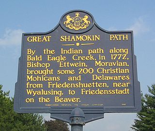
The Great Shamokin Path was a major Native American trail in the U.S. State of Pennsylvania that ran from the native village of Shamokin along the left bank of the West Branch Susquehanna River north and then west to the Great Island. There it left the river and continued further west to Chinklacamoose and finally Kittanning on the Allegheny River.

<span class="mw-page-title-main">Armstrong School District (Pennsylvania)</span> School district in Pennsylvania

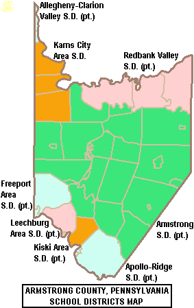
The Armstrong School District is a large, public school district which encompasses approximately 437 square miles (1,130 km2). The district is one of the 500 public school districts of Pennsylvania. In Armstrong County, Pennsylvania, Armstrong School District covers the Boroughs of Applewold, Atwood, Dayton, Elderton, Ford City, Ford Cliff, Kittanning, Manorville, Rural Valley, West Kittanning and Worthington and the Townships of Bethel Township, Boggs Township, Burrell Township, Cadogan Township, Cowanshannock Township, East Franklin Township, Kittanning Township, Manor Township, North Buffalo Township, Pine Township, Plumcreek Township, Rayburn Township, South Bend Township, Valley Township, Washington Township, Wayne Township and West Franklin Township. In Indiana County, Pennsylvania, the district includes the Borough of Smicksburg and West Mahoning Township. According to 2000 federal census data, it served a resident population of 44,970. By 2010, the District's population had declined to 43,301 people. In 2009, Armstrong School District residents' per capita income was $15,449, while the median family income was $36,907.

<span class="mw-page-title-main">Pennsylvania House of Representatives, District 60</span> American legislative district

The 60th Pennsylvania House of Representatives District is located in western Pennsylvania has been represented by Abby Major since 2021.

<span class="mw-page-title-main">Pennsylvania House of Representatives, District 63</span> American legislative district

The 63rd Pennsylvania House of Representatives District is in Western Pennsylvania and has been represented by Donna Oberlander since 2009.

<span class="mw-page-title-main">Pennsylvania Route 128</span> State highway in Armstrong County, Pennsylvania, US

Pennsylvania Route 128 is a 15.8-mile-long (25.4 km) state highway located in Armstrong County, Pennsylvania. The southern terminus is at PA 356 in Freeport. The northern terminus is at PA 66 in Ford City.

<span class="mw-page-title-main">Pennsylvania Route 356</span> State highway in Pennsylvania, US

Pennsylvania Route 356 is a 32.5-mile-long (52.3 km) state highway located in Westmoreland, Allegheny, Butler, and Armstrong counties in Pennsylvania. The southern terminus is at PA 66 near Oklahoma. The northern terminus is at U.S. Route 422 (US 422) near Butler.

<span class="mw-page-title-main">Pennsylvania Route 954</span> State highway in Indiana County, Pennsylvania, US

Pennsylvania Route 954 is a 35-mile-long (56 km) state highway located in Indiana County, Pennsylvania. The southern terminus is at PA 56 in Center Township. The northern terminus is at PA 210 in North Mahoning Township. PA 954 is a two-lane undivided road that serves Indiana, Creekside, Plumville, and Smicksburg. The route intersects U.S. Route 422 and PA 286 in Indiana, PA 110 in Creekside, and PA 85/PA 210 in Plumville. PA 954 was designated in 1928 between Smicksburg and PA 210 in Trade City. The route was extended south to Denton by 1930 and US 422 and PA 80 in Indiana during the 1930s. PA 954 was lengthened to its current terminus in 1971.

References

  1. Includes Allegheny, Washington, Butler, Beaver, Lawrence and Armstrong Counties
  1. "PHMC Historical Markers Search" (Searchable database). Pennsylvania Historical and Museum Commission. Commonwealth of Pennsylvania. Retrieved January 25, 2014.
  2. "Census - Geography Profile: Armstrong County, Pennsylvania". United States Census Bureau . Retrieved April 24, 2022.
  3. "Find a County". National Association of Counties. Archived from the original on May 31, 2011. Retrieved June 7, 2011.
  4. History of Armstrong County, Pennsylvania by Robert Walter Smith
  5. https://www.bc3.edu/news/pdf/BC3-number-one-pa-community-colleges.pdf. Archived (PDF) from the original on October 9, 2022.{{cite web}}: Missing or empty |title= (help)
  6. "2010 Census Gazetteer Files". United States Census Bureau. August 22, 2012. Retrieved March 4, 2015.
  7. "PRISM Climate Group at Oregon State University". prism.oregonstate.edu.
  8. "U.S. Decennial Census". United States Census Bureau. Retrieved March 4, 2015.
  9. "Historical Census Browser". University of Virginia Library. Retrieved March 4, 2015.
  10. Forstall, Richard L., ed. (March 27, 1995). "Population of Counties by Decennial Census: 1900 to 1990". United States Census Bureau. Retrieved March 4, 2015.
  11. "Census 2000 PHC-T-4. Ranking Tables for Counties: 1990 and 2000" (PDF). United States Census Bureau. April 2, 2001. Archived (PDF) from the original on October 9, 2022. Retrieved March 4, 2015.
  12. "State & County QuickFacts". United States Census Bureau. Archived from the original on June 6, 2011. Retrieved November 16, 2013.
  13. "U.S. Census website". United States Census Bureau . Retrieved January 31, 2008.
  14. "P2 HISPANIC OR LATINO, AND NOT HISPANIC OR LATINO BY RACE – 2020: DEC Redistricting Data (PL 94-171) – Armstrong County, Pennsylvania".
  15. Leip, David. "Dave Leip's Atlas of U.S. Presidential Elections". uselectionatlas.org. Retrieved November 14, 2018.
  16. Pennsylvania Department of State (July 17, 2023). "Voter registration statistics by county". dos.pa.gov. Retrieved July 20, 2023.
  17. Armstrong Libraries. Armstrong Libraries. Retrieved on July 23, 2013.
  18. Freeport Area Library Association - Home. Freeportlibrary.org (July 12, 2013). Retrieved on July 23, 2013.
  19. "Decennial Census by Decades" . Retrieved April 20, 2015.

40°49′N79°28′W / 40.81°N 79.46°W / 40.81; -79.46