Murrysville, Pennsylvania

Last updated
Murrysville, Pennsylvania
Murraysville Westmoreland Co, PA.jpg
Hills in Murrysville
Flag of Murrysville, Pennsylvania.png
Murrysville City Seal.jpg
Westmoreland County Pennsylvania Incorporated and Unincorporated areas Murrysville Highlighted.svg
Location of Murrysville in Westmoreland County, Pennsylvania.
Coordinates: 40°26′5″N79°39′24″W / 40.43472°N 79.65667°W / 40.43472; -79.65667
Country United States
State Pennsylvania
County Westmoreland
Settled1788 (as Franklin Township)
Government
  MayorRegis J. Synan
  Chief AdministratorMichael L. Nestico
Area
[1]
  Total36.84 sq mi (95.41 km2)
  Land36.83 sq mi (95.39 km2)
  Water0.01 sq mi (0.02 km2)
Elevation
1,110 ft (338.3 m)
Population
 (2020) [2]
  Total21,006
  Density570.35/sq mi (220.21/km2)
Time zone UTC-5 (Eastern)
  Summer (DST) UTC-4 (Eastern)
ZIP code
15668 [3]
Area code(s) 724, 412
FIPS code 42-52432
Website www.murrysville.com

Murrysville is a home rule municipality in Westmoreland County, Pennsylvania, United States. The population was 21,006 at the 2020 census. It is part of the Pittsburgh metropolitan area.

Contents

History

The approximate site where the Haymaker brothers struck natural gas in Murrysville on November 3, 1878 Haymaker Gas Well in Murrysville April 2016.jpg
The approximate site where the Haymaker brothers struck natural gas in Murrysville on November 3, 1878

The Haymaker Gas Well in Murrysville was the nation's first commercial natural gas well. For some time, it remained the largest commercial gas well in the world. [4] The well was drilled in 1878, and until a gas pipe line was attached to the well in 1883, approximately 35 million cubic feet of gas a day was released into the atmosphere, resulting in a total of about 60 billion cubic feet of natural gas released into the atmosphere from this single site [5] Murrysville was described in the first half of the 20th century as being "the center of a district dotted with gas wells, the first of which was bored in 1878; wild speculation in leases precipitated the open conflict known as the 'Haymaker Riots,' named for the speculator killed in one of them." [6]

Since 1933, Murrysville has had a "tree sign" spelling out the word "Murrysville". The trees were landscaped to grow and form the letters by local Boy Scouts. The sign is situated on a large hill as one enters the Municipality from the Murrysville–Monroeville border, near U.S. Route 22. In 1947, the sign was featured in "Ripley's Believe It Or Not" as the world's largest arboreal sign. [7] (It is no longer the world's largest). The "Y" in the Murrysville sign points to the Haymaker Gas Well.

In 1977, Murrysville was designated the "Gateway to Westmoreland County" by Mayor Walt Dollman in conjunction with the Chamber of Commerce. In 2012, community leaders upgraded sign and landscaping elaborately at the main entrance at the Allegheny / Westmoreland border featuring this designation. As is shown at the introduction of this page, the Gateway designation is featured on the official Seal of the Municipality.

Murrysville became a home rule municipality in August 1976, when its electorate voted for a Charter designating it a Municipality. [8]

Geography

Murrysville is located at 40°26′5″N79°39′24″W / 40.43472°N 79.65667°W / 40.43472; -79.65667 (40.434828, -79.656724). [9] It is roughly 20 miles east of Pittsburgh on U.S. Route 22, [10] just east of the county line that separates Westmoreland and Allegheny counties. Murrysville is a control city on the sign for eastbound US 22 at the eastern end of I-376 in Monroeville.

According to the United States Census Bureau, the municipality had a total area of 36.9 square miles (96 km2), of which, 36.9 square miles (96 km2) of it is land and 0.03% is water.

Among the neighborhoods within Murrysville are Murrysville Heights, Heather Highlands, Franklin Estates, Settlers Ridge (The Ridge), Dunningtown, Newlonsburg, Ringertown, Sardis, and White Valley. Murrysville surrounds, but does not include, the Borough of Export, which is a separate municipal entity.

Surrounding municipalities

Murrysville has eight borders, including Upper Burrell Township to the north, Washington Township to the north and east, Salem Township to the south and southeast, Delmont to the southeast, Penn Township to the south, and the Allegheny County municipalities of Monroeville to the southwest and Plum to the west. The borough of Export is situated inside Murrysville in the south-southeast section.

Demographics

As of the census [11] of 2000, there were 18,872 people, 7,083 households, and 5,630 families located in the municipality. The population density was 511.0 inhabitants per square mile (197.3/km2). There were 7,396 housing units at an average density of 200.3 per square mile (77.3/km2). The racial makeup of the Municipality was 95.38% White, 0.61% African American, 0.05% Native American, 3.28% Asian, 0.01% Pacific Islander, 0.16% from other races, and 0.50% from two or more races. Hispanic or Latino of any race were 0.56% of the population.

There were 7,083 households, out of which 34.5% had children under the age of 18 living with them, 71.8% were married couples living together, 5.5% had a female householder with no husband present, and 20.5% were non-families. 18.4% of all households were made up of individuals, and 9.0% had someone living alone who was 65 years of age or older. The average household size was 2.63 and the average family size was 3.01.

Historical population
CensusPop.Note
1880 81
1930 3,535
1940 3,7977.4%
1950 4,93730.0%
1960 8,51772.5%
1970 12,24443.8%
1980 16,03631.0%
1990 17,2407.5%
2000 18,8729.5%
2010 20,0796.4%
2020 21,0064.6%
source:, [12] [13] [2]

In the Municipality population was spread out, with 24.9% under the age of 18, 4.9% from 18 to 24, 24.3% from 25 to 44, 30.3% from 45 to 64, and 15.6% who were 65 years of age or older. The median age was 43 years. For every 100 females, there were 97.9 males. For every 100 females age 18 and over, there were 93.1 males.

The median income for a household in the Municipality was $64,071, and the median income for a family was $72,740. Males had a median income of $58,553 versus $32,567 for females. The per capita income for the Municipality was $32,017. About 2.2% of families and 2.8% of the population were below the poverty line, including 3.1% of those under age 18 and 3.9% of those age 65 or over.

Government

Murrysville is governed by a mayor (currently Regis J. Synan) [14] who is elected every two years and has executive/administrative powers, and a seven-member council, whose members are elected every four years and have precise legislative powers. [15]

In the mid-1970s, as suburban growth began to occur, the community rapidly transitioned through three forms of government (township, borough, and home rule) and four legal name changes (Franklin Township, Franklin Borough, Murrysville Borough, and Municipality of Murrysville). Since 1976, it has operated under its Home Rule Charter as the Municipality of Murrysville.

On Dec. 6, 2023 Murrysville Council approved gas fracking beneath its two largest parks, Duff and Murrysville Community Park, over the objections of at least 174 residents who petitioned Council. No plan was presented for using the incoming money from the leases. Council member Jason Lemak pointed to fracking operations around the Beaver Run Reservoir “We’re talking about parks, but there has been fracking going on for a long time below the water supply for us and 120,000 people,” he said. [16]

On Dec. 18, 2023 the Municipal Authority of Westmoreland County issued a mandatory water conservation order for Murrysville and others, including energy companies using water from the Beaver Run Reservoir for fracking, due to an ongoing drought. [17] In the Department of Environmental Protection’s 2021 Climate Change Impacts Assessment, it is noted that precipitation patterns are expected to change over the next century. Those changes are likely to include more extreme and intense rainfall — something scientists already have reported noticing — and increased drier weather in between and drought, along with higher temperatures. [18] “In general, we expect worse drought over most of the U.S. as a result of human-caused warming, and Western Pennsylvania is no exception,” said Michael Mann, a professor and director of the Penn Center for Science, Sustainability and the Media at the University of Pennsylvania and author of “Our Fragile Moment.” [19]

Education

Murrysville is part of the Franklin Regional School District. The district operates four schools: Franklin Regional Primary School, Franklin Regional Intermediate School, Franklin Regional Middle School, and Franklin Regional High School, with Dr. Gennaro Piraino as the district's superintendent. [20] The district's high school boasts a graduation rate of 99.3% compared to the national average for public high schools of 82% [21] and is ranked #213 in Newsweek's 2016 "America's Top High Schools". [22] Private schools include Mother of Sorrows Catholic School. The Free Gospel Bible Institute (FGBI), a Holiness Pentecostal bible college, is located in Murrysville. [23]

Notable people

See also

Related Research Articles

<span class="mw-page-title-main">Allegheny County, Pennsylvania</span> County in Pennsylvania, United States

Allegheny County is a county in Pennsylvania, United States. It is located in Southwestern Pennsylvania. As of the 2020 census, the population was 1,250,578, making it the state's second-most populous county, after Philadelphia County. Its county seat and most populous city is Pittsburgh, Pennsylvania's second most populous city. Allegheny County is the center of the Pittsburgh, PA metropolitan statistical area and the Pittsburgh media market.

<span class="mw-page-title-main">Westmoreland County, Pennsylvania</span> County in Pennsylvania, United States

Westmoreland County is a county in the Commonwealth of Pennsylvania, United States, located in the Pittsburgh Metropolitan Statistical Area. As of the 2020 census, the population was 354,663. The county seat is Greensburg and the most populous community is Hempfield Township. It is named after Westmorland, a historic county of England.

<span class="mw-page-title-main">Greene County, Pennsylvania</span> County in Pennsylvania, United States

Greene County is a county in the Commonwealth of Pennsylvania. As of the 2020 census, the population was 35,954. Its county seat is Waynesburg. Greene County was created on February 9, 1796, from part of Washington County and named for General Nathanael Greene.

<span class="mw-page-title-main">Churchill, Pennsylvania</span> Borough in Pennsylvania, United States

Churchill is a borough in Allegheny County, Pennsylvania, United States. The population was 3,157 at the 2020 census. It is a residential suburb of the Pittsburgh metropolitan area. The town was named from the hilltop Beulah Presbyterian Church.

<span class="mw-page-title-main">Franklin Park, Pennsylvania</span> Borough in Pennsylvania, United States

Franklin Park is a borough in Allegheny County, Pennsylvania, United States. The population was 15,479 at the 2020 census. It is a suburb of the Pittsburgh metropolitan area.

<span class="mw-page-title-main">Monroeville, Pennsylvania</span> Borough in Pennsylvania, United States

Monroeville is a home rule municipality in Allegheny County, Pennsylvania, United States. It is a suburb with mixed residential and commercial developments located about 10 miles (16 km) east of Pittsburgh. As of the 2020 census, Monroeville was home to 28,640 people.

<span class="mw-page-title-main">Penn Hills, Pennsylvania</span> Home rule township in Pennsylvania, United States

Penn Hills is a township with home rule status in Allegheny County, Pennsylvania, United States. The population was 41,059 as of the 2020 census. A suburb of Pittsburgh, Penn Hills is the second-largest municipality in Allegheny County.

<span class="mw-page-title-main">Plum, Pennsylvania</span> Borough in Pennsylvania, United States

Plum is a borough in Allegheny County, Pennsylvania, United States. The population was 27,144 at the 2020 census. A suburb of the Pittsburgh metropolitan area, it is located northeast of the city in what is commonly referred to as the East Hills suburbs.

<span class="mw-page-title-main">Bell Township, Westmoreland County, Pennsylvania</span> Township in Pennsylvania, United States

Bell Township is a township in Westmoreland County, Pennsylvania, United States. The population was 2,080 at the 2020 decennial census.

<span class="mw-page-title-main">Delmont, Pennsylvania</span> Borough in Pennsylvania, United States

Delmont is a borough in Westmoreland County, Pennsylvania. The population was 2,592 at the 2020 census.

<span class="mw-page-title-main">Donegal Township, Westmoreland County, Pennsylvania</span> Township in Pennsylvania, United States

Donegal Township is a township in Westmoreland County, Pennsylvania, United States. The population was 2,192 at the 2020 census, a decrease of 9% compared to 2010.

<span class="mw-page-title-main">Export, Pennsylvania</span> Borough in Pennsylvania, United States

Export is a borough in Westmoreland County, Pennsylvania, United States, surrounded entirely by the municipality of Murrysville. The population was 893 at the 2020 census.

<span class="mw-page-title-main">Penn Township, Westmoreland County, Pennsylvania</span> Township in Pennsylvania, United States

Penn Township is a township in Westmoreland County, Pennsylvania, United States.

<span class="mw-page-title-main">Unity Township, Pennsylvania</span> Township in Pennsylvania, United States

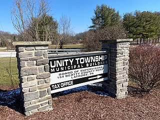
Unity Township is a township in Westmoreland County, Pennsylvania, United States. The population was 21,724 at the 2020 census, a decline of approximately 4% compared to the 2010 census.

<span class="mw-page-title-main">Washington Township, Westmoreland County, Pennsylvania</span> Township in Pennsylvania, United States

Washington Township is a township in Westmoreland County, Pennsylvania, United States. It was founded in 1789 from Salem Township. At that time, it included the present-day municipalities of Allegheny, Lower Burrell, Upper Burrell, and most of Bell. In 2020, the population of Washington Twp was 6,887.

<span class="mw-page-title-main">Trafford, Pennsylvania</span> Borough in Pennsylvania, United States

Trafford is a borough in Allegheny and Westmoreland counties in the U.S. state of Pennsylvania. Located near Pittsburgh in western Pennsylvania, the borough lies primarily in Westmoreland County; only a small portion extends into Allegheny County. It was incorporated in 1904 from the northernmost corner of North Huntingdon Township, and was named by George Westinghouse for Trafford near Manchester, England. Westinghouse purchased the land in 1902, and the Trafford Foundry began operations on October 3, 1903. The population was 3,317 at the 2020 census. Of this, 3,113 were in Westmoreland County, and only 61 were in Allegheny County.

<span class="mw-page-title-main">Wilkins Township, Pennsylvania</span> Township in Pennsylvania, United States

Wilkins Township is a township in Allegheny County, Pennsylvania, United States. The population was 6,357 at the 2010 census. It is served by Pennsylvania's 12th congressional district, the 43rd District of the Pennsylvania State Senate, and the 34th District of the Pennsylvania State House of Representatives.

<span class="mw-page-title-main">Pennsylvania Route 286</span> State highway in Pennsylvania, US

Pennsylvania Route 286 is a 69-mile-long (111 km), east–west state highway located in Allegheny, Westmoreland, Indiana, and Clearfield counties in Pennsylvania.

The Franklin Regional High School stabbing was a mass stabbing that occurred on April 9, 2014, at Franklin Regional High School in Murrysville, Pennsylvania. Alex Hribal, a 16-year-old sophomore at the school, used a pair of eight-inch kitchen knives to stab and slash 20 students and a security guard. Four students sustained life-threatening injuries, but all survived.

<span class="mw-page-title-main">Westmoreland Heritage Trail</span> Rail trail in Pennsylvania, U.S.

The Westmoreland Heritage Trail is a partially completed rail trail in southwestern Pennsylvania. As of 2019, 18.0 miles of the 21.9 planned miles of trail are complete, including an 8.7 mile section from Saltsburg to the fringe of Delmont as well as a 9.3 mile section from Trafford to Export.

References

  1. "ArcGIS REST Services Directory". United States Census Bureau. Retrieved October 12, 2022.
  2. 1 2 "Census Population API". United States Census Bureau. Retrieved Oct 12, 2022.
  3. "Murrysville PA ZIP Code". zipdatamaps.com. 2023. Retrieved May 13, 2023.
  4. "Murrysville Gas Well Historical Marker". ExplorePAHistory.com. Retrieved 25 January 2020.
  5. Muller, Edward K. (1994). Westmoreland County, Pennsylvania : an inventory of historic engineering and industrial sites. Washington, DC: National Park Service. p. 323. Retrieved February 25, 2024.
  6. Federal Writers' Project (1940). Pennsylvania: A Guide to the Keystone State (1st ed.). New York: Oxford University Press. p. 394.
  7. Cleary, Caitlin (2005-06-06). "Murrysville landmark is fading from view". Pittsburgh Post-Gazette.
  8. Population Estimates Boundary Changes Archived 2006-02-06 at the Wayback Machine , United States Census Bureau, 2007-07-01. Accessed 2008-11-06.
  9. "US Gazetteer files: 2010, 2000, and 1990". United States Census Bureau. 2011-02-12. Retrieved 2011-04-23.
  10. "Murrysville: United States". Geographical names. Retrieved 2014-04-09.
  11. "U.S. Census website". United States Census Bureau . Retrieved 2008-01-31.
  12. "Land Patterns" (PDF). Municipality of Murrysville. Archived from the original (PDF) on August 8, 2004. Retrieved 2007-10-26.
  13. "About Murrysville". Municipality of Murrysville. Archived from the original on 2013-11-02. Retrieved 2011-03-09.
  14. "Welcome from the Mayor". The Municipality of Murrysville. Retrieved 2018-02-01.
  15. Murrysville Council Archived 2012-05-12 at the Wayback Machine
  16. Varine, Patrick (2023-12-06). "Murrysville Council OKs lease for gas, oil rights under 2 parks". TribLIVE.com. Retrieved 2024-04-14.
  17. Cholodofsky, Rich (2023-12-18). "Westmoreland municipal authority issues mandatory water conservation order". TribLIVE.com. Retrieved 2024-04-14.
  18. "Impacts". Department of Environmental Protection. Retrieved 2024-04-14.
  19. Signorini, Renatta (2023-12-20). "Shrinking resource: Customers heed conservation order but Beaver Run Reservoir continues drop toward record-low level". TribLIVE.com. Retrieved 2024-04-14.
  20. "Franklin Regional School District" . Retrieved 25 January 2020.
  21. http://www.ed.gov/news/press-releases/us-high-school-graduation-rate-hits-new-record-high-0 U.S. High School Graduation Rate Hits New Record High | US Department of Education
  22. http://www.newsweek.com/high-schools/americas-top-high-schools-2016 America's Top High Schools 2016 | Newsweek
  23. Scott, Rebekah (5 January 2006). "Murrysville Bible school produces teachers, preachers, prophets and apostles". Pittsburgh Post-Gazette . Retrieved 17 June 2022.
  24. 1 2 Rouvalis, Christina (October 21, 2013). "Inside the 'Dance Moms' Empire". Pittsburgh Magazine. Retrieved May 21, 2017.
  25. Stremple, Caiden. "Caiden". www.youtube.com. Retrieved 2024-03-17.