Washington County | |
---|---|
Coordinates: 40°11′N80°15′W / 40.19°N 80.25°W | |
Country | United States |
State | Pennsylvania |
Founded | March 28, 1781 |
Named for | George Washington |
Seat | Washington |
Largest township | Peters Township |
Area | |
• Total | 861 sq mi (2,230 km2) |
• Land | 857 sq mi (2,220 km2) |
• Water | 3.9 sq mi (10 km2) 0.5% |
Population (2020) | |
• Total | 209,349 |
• Density | 244/sq mi (94/km2) |
Time zone | UTC−5 (Eastern) |
• Summer (DST) | UTC−4 (EDT) |
Congressional district | 14th |
Website | washingtoncopa |
Washington County is a county in the Commonwealth of Pennsylvania, United States. As of the 2020 census, the population was 209,349. [1] Its county seat is Washington. [2] The county is part of the Greater Pittsburgh region of the state. [lower-alpha 1]
The county is home to Washington County Airport, three miles (4.8 km) southwest of Washington.
The county was created on March 28, 1781, from part of Westmoreland County. The city and county were both obviously named after American Revolutionary War leader George Washington, who eventually became the first President of the United States. The town of Charleroi got its name from the Belgian city of Charleroi. There lived many Belgian immigrants in the Monongahela area at the end of the 19th century, some of whom were glass makers. [3] [4]
According to the U.S. Census Bureau, the county has a total area of 861 square miles (2,230 km2), of which 857 square miles (2,220 km2) is land and 3.9 square miles (10 km2) (0.5%) is water. [5]
The flag of Washington County, Pennsylvania consists of a light blue background with the county's seal in the middle. The seal consists of the county courthouse, a covered bridge, an Indigenous American, and an early settler. This montage has the words "Historical Washington County" and "1781" inside a circle.
Washington County has a humid continental climate (Köppen Dfb), with warm summers and cold, snowy winters. Precipitation is highest in the summer months, with an annual average of 38.87 in (987 mm). Snow usually falls between November and April, with an average of 37.8 in (96 cm).
Climate data for Washington, Pennsylvania (3mi NE) (1981–2010 normals, extremes 1975–present) | |||||||||||||
---|---|---|---|---|---|---|---|---|---|---|---|---|---|
Month | Jan | Feb | Mar | Apr | May | Jun | Jul | Aug | Sep | Oct | Nov | Dec | Year |
Record high °F (°C) | 70 (21) | 75 (24) | 82 (28) | 90 (32) | 94 (34) | 93 (34) | 100 (38) | 96 (36) | 95 (35) | 87 (31) | 80 (27) | 76 (24) | 100 (38) |
Mean daily maximum °F (°C) | 35.1 (1.7) | 38.5 (3.6) | 48.5 (9.2) | 60.7 (15.9) | 69.4 (20.8) | 78.0 (25.6) | 81.6 (27.6) | 80.7 (27.1) | 73.9 (23.3) | 62.3 (16.8) | 51.0 (10.6) | 39.1 (3.9) | 59.6 (15.3) |
Daily mean °F (°C) | 26.0 (−3.3) | 28.6 (−1.9) | 37.2 (2.9) | 48.6 (9.2) | 57.5 (14.2) | 66.2 (19.0) | 70.0 (21.1) | 69.0 (20.6) | 61.9 (16.6) | 50.6 (10.3) | 41.1 (5.1) | 30.5 (−0.8) | 48.9 (9.4) |
Mean daily minimum °F (°C) | 16.8 (−8.4) | 18.7 (−7.4) | 26.0 (−3.3) | 36.5 (2.5) | 45.6 (7.6) | 54.4 (12.4) | 58.5 (14.7) | 57.3 (14.1) | 49.9 (9.9) | 39.0 (3.9) | 31.1 (−0.5) | 21.8 (−5.7) | 38.0 (3.3) |
Record low °F (°C) | −25 (−32) | −20 (−29) | −1 (−18) | 9 (−13) | 20 (−7) | 32 (0) | 38 (3) | 29 (−2) | 30 (−1) | 18 (−8) | −4 (−20) | −16 (−27) | −25 (−32) |
Average precipitation inches (mm) | 2.87 (73) | 2.47 (63) | 3.25 (83) | 3.11 (79) | 4.16 (106) | 3.91 (99) | 3.94 (100) | 3.19 (81) | 3.28 (83) | 2.46 (62) | 3.37 (86) | 2.97 (75) | 38.87 (987) |
Average snowfall inches (cm) | 10.5 (27) | 9.3 (24) | 6.6 (17) | 1.2 (3.0) | 0 (0) | 0 (0) | 0 (0) | 0 (0) | 0 (0) | 0.2 (0.51) | 2.1 (5.3) | 7.9 (20) | 37.8 (96) |
Average precipitation days (≥ 0.01 in) | 16 | 14 | 14 | 14 | 15 | 12 | 12 | 11 | 11 | 13 | 14 | 15 | 162 |
Average snowy days (≥ 0.1 in) | 12 | 10 | 5 | 1 | 0 | 0 | 0 | 0 | 0 | 0 | 3 | 8 | 38 |
Source: NOAA [6] |
Census | Pop. | Note | %± |
---|---|---|---|
1790 | 23,892 | — | |
1800 | 28,298 | 18.4% | |
1810 | 36,289 | 28.2% | |
1820 | 40,038 | 10.3% | |
1830 | 42,784 | 6.9% | |
1840 | 41,279 | −3.5% | |
1850 | 44,939 | 8.9% | |
1860 | 46,805 | 4.2% | |
1870 | 48,483 | 3.6% | |
1880 | 55,418 | 14.3% | |
1890 | 71,155 | 28.4% | |
1900 | 92,181 | 29.5% | |
1910 | 143,680 | 55.9% | |
1920 | 188,992 | 31.5% | |
1930 | 204,802 | 8.4% | |
1940 | 210,852 | 3.0% | |
1950 | 209,628 | −0.6% | |
1960 | 217,271 | 3.6% | |
1970 | 210,876 | −2.9% | |
1980 | 217,074 | 2.9% | |
1990 | 204,584 | −5.8% | |
2000 | 202,897 | −0.8% | |
2010 | 207,820 | 2.4% | |
2020 | 209,349 | 0.7% | |
U.S. Decennial Census [7] 1790–1960 [8] 1900–1990 [9] 1990–2000 [10] 2010–2019 [11] 2010-2020 [12] |
As of the census [13] of 2000, there were 202,897 people, 81,130 households, and 56,060 families residing in the county. The population density was 237 people per square mile (92 people/km2). There were 87,267 housing units at an average density of 102 per square mile (39/km2). The racial makeup of the county was 95.27% White, 3.26% Black or African American, 0.09% Native American, 0.36% Asian, 0.02% Pacific Islander, 0.19% from other races, and 0.82% from two or more races. 0.58% of the population were Hispanic or Latino of any race. 18.3% were of German, 17.2% Italian, 10.6% Irish, 8.6% English, 7.9% Polish and 6.2% American ancestry.
There were 81,130 households, out of which 28.40% had children under the age of 18 living with them, 55.20% were married couples living together, 10.30% had a female householder with no husband present, and 30.90% were non-families. 27.00% of all households were made up of individuals, and 13.20% had someone living alone who was 65 years of age or older. The average household size was 2.44 and the average family size was 2.96.
In the county, the population was spread out, with 22.20% under the age of 18, 7.70% from 18 to 24, 27.20% from 25 to 44, 25.00% from 45 to 64, and 17.90% who were 65 years of age or older. The median age was 41 years. For every 100 females there were 92.40 males. For every 100 females age 18 and over, there were 89.00 males.
As of 1800, this county was largely settled by people of Scot-Irish heritage because "prime lands" were already taken by the Germans and the Quakers.
Race | Num. | Perc. |
---|---|---|
White (NH) | 186,900 | 89.3% |
Black or African American (NH) | 6,861 | 3.3% |
Native American (NH) | 230 | 0.11% |
Asian (NH) | 1,998 | 1% |
Pacific Islander (NH) | 63 | 0.03% |
Other/Mixed (NH) | 9,276 | 4.43% |
Hispanic or Latino | 4,021 | 2% |
Year | Republican | Democratic | Third party | |||
---|---|---|---|---|---|---|
No. | % | No. | % | No. | % | |
2020 | 72,080 | 60.70% | 45,088 | 37.97% | 1,588 | 1.34% |
2016 | 61,386 | 60.03% | 36,322 | 35.52% | 4,559 | 4.46% |
2012 | 53,230 | 56.04% | 40,345 | 42.48% | 1,403 | 1.48% |
2008 | 50,752 | 51.52% | 46,122 | 46.82% | 1,642 | 1.67% |
2004 | 47,673 | 49.57% | 48,225 | 50.14% | 279 | 0.29% |
2000 | 37,339 | 44.22% | 44,961 | 53.25% | 2,141 | 2.54% |
1996 | 27,777 | 35.73% | 40,952 | 52.67% | 9,016 | 11.60% |
1992 | 21,977 | 26.05% | 46,143 | 54.70% | 16,244 | 19.25% |
1988 | 28,651 | 37.43% | 47,527 | 62.08% | 375 | 0.49% |
1984 | 34,782 | 40.47% | 50,911 | 59.24% | 244 | 0.28% |
1980 | 32,532 | 39.66% | 45,295 | 55.23% | 4,191 | 5.11% |
1976 | 32,827 | 39.43% | 49,317 | 59.24% | 1,107 | 1.33% |
1972 | 42,587 | 54.00% | 34,781 | 44.10% | 1,494 | 1.89% |
1968 | 28,023 | 32.98% | 47,805 | 56.26% | 9,140 | 10.76% |
1964 | 24,127 | 27.49% | 63,482 | 72.34% | 147 | 0.17% |
1960 | 38,348 | 41.59% | 53,729 | 58.28% | 120 | 0.13% |
1956 | 39,465 | 45.04% | 48,052 | 54.84% | 98 | 0.11% |
1952 | 36,041 | 39.16% | 55,725 | 60.55% | 270 | 0.29% |
1948 | 26,860 | 35.73% | 46,327 | 61.63% | 1,979 | 2.63% |
1944 | 27,615 | 37.30% | 46,023 | 62.17% | 392 | 0.53% |
1940 | 29,026 | 36.21% | 50,829 | 63.42% | 296 | 0.37% |
1936 | 23,342 | 30.25% | 52,878 | 68.52% | 948 | 1.23% |
1932 | 21,447 | 40.82% | 28,934 | 55.07% | 2,155 | 4.10% |
1928 | 31,099 | 63.61% | 17,149 | 35.07% | 645 | 1.32% |
1924 | 22,315 | 60.64% | 6,706 | 18.22% | 7,776 | 21.13% |
1920 | 18,514 | 62.49% | 8,827 | 29.80% | 2,284 | 7.71% |
1916 | 10,367 | 52.39% | 7,747 | 39.15% | 1,674 | 8.46% |
1912 | 4,297 | 22.98% | 5,563 | 29.75% | 8,837 | 47.26% |
1908 | 11,430 | 56.31% | 7,018 | 34.57% | 1,850 | 9.11% |
1904 | 11,530 | 66.01% | 4,886 | 27.97% | 1,051 | 6.02% |
1900 | 10,408 | 59.40% | 6,380 | 36.41% | 733 | 4.18% |
1896 | 10,798 | 57.93% | 7,384 | 39.61% | 458 | 2.46% |
1892 | 8,060 | 51.24% | 6,847 | 43.53% | 822 | 5.23% |
1888 | 7,801 | 54.83% | 5,847 | 41.10% | 579 | 4.07% |
1884 | 6,699 | 50.21% | 5,849 | 43.84% | 793 | 5.94% |
1880 | 6,451 | 51.04% | 5,850 | 46.29% | 338 | 2.67% |
The Democratic Party has been historically dominant in county-level politics and national politics between 1932 and 2004, only voting Republican for president in Richard Nixon's 1972 landslide victory over George McGovern. However, like much of Appalachian coal country, Washington has trended strongly Republican in recent years. In 2000, Democrat Al Gore won 53% of the vote and Republican George W. Bush won 44%. In 2004, Democrat John Kerry received 50.14% of the vote and Bush received 49.57% a difference of 552 votes. In 2008, Republican John McCain won 51% to Democrat Barack Obama's 46% and each of the three state row office winners carried Washington County.
As of January 8, 2024, there are 142,146 registered voters in Washington county. Registered Republicans have a plurality of 68,164 registered voters, compared to 56,044 registered Democrats, 13,943 registered non-affiliated voters, and 3,995 voters registered to other parties. [16]
Voter registration and party enrollment | |||||
---|---|---|---|---|---|
Party | Number of voters | Percentage | |||
Republican | 68,164 | 47.95% | |||
Democratic | 56,044 | 39.42% | |||
Independent | 13,943 | 9.81% | |||
Third Party | 3,995 | 2.81% | |||
Total | 142,146 | 100% |
Washington County is administered by a three-member publicly elected commission. Each commissioner serves in four-year terms. Elections occur in the odd-numbered years that precede U.S. presidential elections. All three Commissioners are chosen in the same election, and voters may vote for no more than two of the candidates. By state law, the commission must have a minority party guaranteeing a political split on the commission. The Commissioners are responsible for the management of the fiscal and administrative functions of the county.
Commissioner | Party | Title |
---|---|---|
Nick Sherman | Republican | |
Lawrence Maggi | Democratic | |
Electra Janis | Republican | |
Maggi was the Democratic nominee for Pennsylvania's 18th congressional district against Republican incumbent Tim Murphy in 2012. Maggi lost to Murphy and earned only 36 percent of the vote. Irey Vaughan was the Republican candidate for Pennsylvania's 12th congressional district and lost to the late Democratic incumbent John Murtha in the 2006 election.
On November 7, 2023, Nick Sherman and Lawrence Maggi were reelected as county commissioners. Electra Janis won her first term as county commissioner. [17]
Office | Official | Party |
---|---|---|
Clerk of Courts | Ray Phillips | Republican |
Controller | April Sloane | Republican |
Coroner | Timothy Warco | Democratic |
District Attorney | Jason M. Walsh | Republican |
Prothonotary | Laura Hough | Republican |
Recorder of Deeds | Carrie Perrell | Republican |
Register of Wills | James Roman | Republican |
Sheriff | Anthony Andronas | Republican |
Treasurer | Tom Flickinger | Republican |
District | Representative | Party |
---|---|---|
15 | Josh Kail | Republican |
39 | Andrew Kuzma | Republican |
40 | Natalie Mihalek | Republican |
46 | Jason Ortitay | Republican |
48 | Timothy O'Neal | Republican |
50 | Bud Cook | Republican |
District | Senator | Party |
---|---|---|
46 | Camera Bartolotta | Republican |
District | Representative | Party |
---|---|---|
14 | Guy Reschenthaler | Republican |
Senator | Party |
---|---|
John Fetterman | Democrat |
Bob Casey, Jr. | Democrat |
Pony League baseball was founded in Washington County in 1951 for 13 and 14 year old boys and its headquarters are located here. As of 2016, more than a half-million youth in the U.S. and 40 other nations participate. The televised Pony League World Series held annually in August at Washington's Lew Hays Pony Field attracts teenage teams from around the world. [19]
Washington County is also the home of the Pennsylvania Trolley Museum. [20] Washington County is also famous for its Rock Shelters at Meadowcroft Village, which are one of the best preserved and oldest Pre-Clovis Native American dwellings in the country. [21] The county has 21 covered bridges still standing. [22]
The Whiskey Rebellion culminated in Washington. The home of David Bradford, one of the rebellion leaders, is located in Washington and is a national landmark. [23] Just a couple blocks away is the F. Julius LeMoyne House, which serves as the headquarters of the Washington County Historical Society.
Washington County is the home of the first crematory in the United States. [24] [25]
In 1981, the Pennsylvania Historical and Museum Commission installed a historical marker noting the historic importance of the county. [26]
Under Pennsylvania law, there are four types of incorporated municipalities: cities, boroughs, townships, and, in at most two cases, towns. The following cities, boroughs and townships are located in Washington County:
Census-designated places are geographical areas designated by the U.S. Census Bureau for the purposes of compiling demographic data. They are not actual jurisdictions under Pennsylvania law.
The population ranking of the following table is based on the 2010 census of Washington County. [30]
†county seat
Rank | City/Town/etc. | Municipal type | Population (2010 Census) |
---|---|---|---|
1 | † Washington | City | 13,663 |
2 | Canonsburg | Borough | 8,992 |
3 | California | Borough | 6,795 |
4 | Donora | Borough | 4,781 |
5 | McMurray | CDP | 4,647 |
6 | Monongahela | City | 4,300 |
7 | Charleroi | Borough | 4,120 |
8 | Thompsonville | CDP | 3,520 |
9 | Centerville | Borough | 3,263 |
10 | Wolfdale | CDP | 2,888 |
11 | Gastonville | CDP | 2,818 |
12 | McGovern | CDP | 2,742 |
13 | Bentleyville | Borough | 2,581 |
14 | Muse | CDP | 2,504 |
15 | Cecil-Bishop | CDP | 2,476 |
16 | East Washington | Borough | 2,234 |
17 | New Eagle | Borough | 2,184 |
18 | McDonald (partially in Allegheny County ) | Borough | 2,149 |
19 | Wickerham Manor-Fisher | CDP | 1,728 |
20 | Baidland | CDP | 1,563 |
21 | Burgettstown | Borough | 1,388 |
22 | North Charleroi | Borough | 1,313 |
23 | Houston | Borough | 1,296 |
24 | Speers | Borough | 1,154 |
25 | Ellsworth | Borough | 1,027 |
26 | West Brownsville | Borough | 992 |
27 | Midway | Borough | 913 |
28 | Claysville | Borough | 829 |
29 | Meadowlands | CDP | 822 |
30 | Roscoe | Borough | 812 |
31 | Avella | CDP | 804 |
32 | Hickory | CDP | 740 |
33 | Paris | CDP | 732 |
34 | Deemston | Borough | 722 |
35 | Langeloth | CDP | 717 |
36 | Millsboro | CDP | 666 |
37 | Eighty Four | CDP | 657 |
38 | Cokeburg | Borough | 630 |
39 | West Alexander | CDP | 604 |
40 | Slovan | CDP | 555 |
41 | Lawrence | CDP | 540 |
42 | Allenport | Borough | 537 |
43 | Joffre | CDP | 536 |
44 | Stockdale | Borough | 502 |
45 | Marianna | Borough | 494 |
46 | Beallsville | Borough | 466 |
47 | Finleyville | Borough | 461 |
48 | Long Branch | Borough | 447 |
49 | Bulger | CDP | 407 |
50 | Fredericktown | CDP | 403 |
51 | Atlasburg | CDP | 401 |
52 | Wylandville | CDP | 391 |
53 | Dunlevy | Borough | 381 |
54 | Hendersonville | CDP | 325 |
55 | Elco | Borough | 323 |
56 | Elrama | CDP | 307 |
57 | Southview | CDP | 276 |
58 | Aaronsburg | CDP | 259 |
59 | Twilight | Borough | 233 |
60 | Taylorstown | CDP | 217 |
61 | Westland | CDP | 167 |
62 | Van Voorhis | CDP | 166 |
T-63 | Coal Center | Borough | 139 |
T-63 | West Middletown | Borough | 139 |
64 | Cross Creek | CDP | 137 |
65 | Green Hills | Borough | 29 |
Allegheny County is a county in Pennsylvania, United States. As of the 2020 census, the population was 1,250,578, making it the state's second-most populous county, after Philadelphia County. Its county seat and most populous city is Pittsburgh, Pennsylvania's second most populous city. The county is part of the Greater Pittsburgh region of the state, and is the center of the Pittsburgh media market.
Armstrong County is a county in the Commonwealth of Pennsylvania. As of the 2020 census, the population was 65,558. The county seat is Kittanning. The county was organized on March 12, 1800, from parts of Allegheny, Westmoreland and Lycoming Counties. It was named in honor of John Armstrong, who represented Pennsylvania in the Continental Congress and served as a major general during the Revolutionary War.
Westmoreland County is a county in the Commonwealth of Pennsylvania, United States, located in the Pittsburgh Metropolitan Statistical Area. As of the 2020 census, the population was 354,663. The county seat is Greensburg and the most populous community is Hempfield Township. It is named after Westmorland, a historic county of England. The county is part of the Southwest Pennsylvania region of the state.
Warren County is a county in the Commonwealth of Pennsylvania. As of the 2020 census, the population was 38,587. Its county seat is Warren. The county was established in 1800 from parts of Allegheny and Lycoming counties; attached to Crawford County until 1805 and then to Venango County until Warren was formally established in 1819.
McKean County is a rural county in the Commonwealth of Pennsylvania. As of the 2020 census, the population was 40,432. Its county seat is Smethport. The county was created in 1804 and organized in 1826. It was named in honor of former Pennsylvania Governor and Declaration of Independence signer Thomas McKean. The county is part of the North Central Pennsylvania region of the state.
Forest County is a county in the Commonwealth of Pennsylvania. As of the 2020 census, the population was 6,973, making it the third-least populous county in Pennsylvania. Its county seat is Tionesta. The county was created in 1848 and later organized in 1857. The county is part of the North Central Pennsylvania region of the state.
Cambria County is a county in the Commonwealth of Pennsylvania. As of the 2020 census, the population was 133,472. Its county seat is Ebensburg. The county was created on March 26, 1804, from parts of Bedford, Huntingdon, and Somerset counties and later organized in 1807. It was named for the nation of Wales, which in Latin is known as "Cambria". The county is part of the Southwest Pennsylvania region of the state.
Butler County is a county in the Commonwealth of Pennsylvania. As of the 2020 census, the population was 193,763. Its county seat is Butler. Butler County was created on March 12, 1800, from part of Allegheny County and named in honor of General Richard Butler, a hero of the American Revolution. The county is part of the Greater Pittsburgh region of the state.
Blair County is a county in the Commonwealth of Pennsylvania. As of the 2020 census, the population was 122,822. Its county seat is Hollidaysburg, and its largest city is Altoona. The county was created on February 26, 1846, from parts of Huntingdon and Bedford counties. The county is part of the Southwest Pennsylvania region of the state.
Jefferson Hills is a borough in Allegheny County, Pennsylvania, United States. In the 2020 census, the population was 12,424. It is part of the Pittsburgh metropolitan area.
The Township of North Fayette is a township in Allegheny County, Pennsylvania, United States. The township is a suburb of Pittsburgh. The population was 16,166 at the 2020 census.
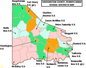
Burgettstown is a borough in northwestern Washington County, Pennsylvania, United States. The population was 1,424 according to the 2020 census. It is part of the Pittsburgh metropolitan area.
Canonsburg is a borough in Washington County, Pennsylvania, United States, 18 miles (29 km) southwest of Pittsburgh. The population was 9,735 at the 2020 census. Canonsburg was laid out by Colonel John Canon in 1789 and incorporated in 1802. The town lies in a rich coal district, and most of the town's work force once worked in local steel mills or coal mines. Interstate 79 and U.S. Route 19 pass through the town, as does the Pittsburgh and Ohio Central Railroad. A trolley used to operate from Washington, Pennsylvania to Pittsburgh through the borough until 1953.
Charleroi is a borough in Washington County, Pennsylvania, United States, along the Monongahela River, 21 miles south of Pittsburgh.
Donora is a borough in Washington County, Pennsylvania, United States, approximately 20 miles (32 km) south of Pittsburgh along the Monongahela River. The population was 4,558 as of the 2020 census.
Rostraver Township is a township in Westmoreland County, Pennsylvania, United States. The population was 11,374 at the 2020 census.
Pennsylvania Route 88 is a 68-mile-long (109 km) north–south state highway located in southwestern Pennsylvania. The southern terminus of the route is at U.S. Route 119 (US 119) in Point Marion less than 2 miles (3 km) from the Pennsylvania-West Virginia border. The northern terminus is at PA 51 in Pittsburgh. PA 88 runs parallel to the Monongahela River for almost its entire length.
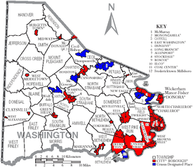
Pennsylvania Route 837 is a state route located in western Pennsylvania. The southern terminus of the route is at Pennsylvania Route 88 in the Carroll Township hamlet of Wickerham Manor. The northern terminus is at U.S. Route 19 and PA 51 near downtown Pittsburgh at the junction of the Ohio, Allegheny and Monongahela rivers. The highway parallels the Monongahela River for all of its route with the exceptions of its extreme north and south ends. Popular amusement park Kennywood is located along this route.
Pennsylvania Route 906 is a 10.6-mile-long (17.1 km) state highway located in Fayette, Westmoreland, and Allegheny counties in Pennsylvania. The southern terminus is at PA 201 in Washington Township. The northern terminus is at PA 136 in Forward Township.
The Mid Mon Valley Transit Authority is a public transportation service that is located in Washington County, Westmoreland County, and a small portion of Fayette County in Pennsylvania. It provides inter-city bus and paratransit service to select communities within the area.