Philadelphia Main Line

Last updated

Main Line of Philadelphia
Main Line, Philadelphia Main Line
Collection of suburban communities
Main Line 1895.jpg
Map of the historic Philadelphia Main Line, c.1895
Pennsylvania in United States (US48).svg
Location of Pennsylvania in the United States
Coordinates: 40°01′08″N75°18′47″W / 40.019°N 75.313°W / 40.019; -75.313
CountryFlag of the United States.svg  United States
State Flag of Pennsylvania.svg  Pennsylvania
County Primarily Montgomery and Chester counties; certain northern parts of Delaware County
Named for The Pennsylvania Railroad's Main Line
Demonym Main Liner
Time zone UTC-5 (EST)
  Summer (DST) UTC-4 (EDT)
Area codes 215, 267, 445, 610, and 484
La Ronda Estate (1929-2009) in Bryn Mawr, by architect Addison Mizner) Laronda2.jpg
La Ronda Estate (1929–2009) in Bryn Mawr, by architect Addison Mizner)

The Philadelphia Main Line, known simply as the Main Line, is an informally delineated historical and social region of suburban Philadelphia, Pennsylvania. Lying along the former Pennsylvania Railroad's once prestigious Main Line, it runs northwest from Center City Philadelphia parallel to Lancaster Avenue, also known as U.S. Route 30.

Contents

The railroad first connected the Main Line towns in the 19th century. They became home to sprawling country estates belonging to Philadelphia's wealthiest families, and over the decades became a bastion of "old money". The Main Line includes some of the wealthiest communities in the country, including Gladwyne, [1] Villanova, Radnor, Haverford, and Merion. [2] [3] Today, the railroad is Amtrak's Keystone Corridor, along which SEPTA's Paoli/Thorndale Line operates.

History

17th and 18th centuries

Wayne Station on SEPTA's Paoli/Thorndale Line after renovations in 2010 Wayne-Station-Pennsylvania-08.27.2010.jpg
Wayne Station on SEPTA's Paoli/Thorndale Line after renovations in 2010

The Main Line region was long part of Lenapehoking, the homeland of the matrilineal Lenape Native Americans (the "true people", or "Delaware Indians"). Europeans arrived in the 1600s, after William Penn sold a tract of land, called the Welsh Tract, to a group of Welsh Quakers in London in 1681. This accounts for the many Welsh place names in the area. [4] However, what might be termed the "Celtification" of many Main Line place and street names occurred long after colonial times. So, for instance, as a marketing device to attract wealthy new residents, the area once awkwardly named Athensville became the more culturally glamorous Ardmore (Ardmore is a place name found in Ireland and Scotland) in 1873.

19th century

The Pennsylvania Railroad built its main line during the early 19th century as part of the Main Line of Public Works that spanned Pennsylvania. Later in the century, the railroad, which owned much of the land surrounding the tracks, encouraged the development of this picturesque environment by building way stations along the portion of its track closest to Philadelphia. The benefits of what was touted as "healthy yet cultivated country living" attracted Philadelphia's social elite, many of whom had one house in the city and another larger "country home" on the Main Line.

20th century

In the 20th century, many wealthy Philadelphia families moved to the Main Line suburbs. Part of the national trend of suburbanization, this drove rapid investment, prosperity, and growth that turned the area into greater Philadelphia's most affluent and fashionable region. Estates with sweeping lawns and towering maples, the débutante balls and the Merion Cricket Club, which drew crowds of 25,000 spectators to its matches in the early 1900s, were the setting for the 1940 Grant/Hepburn/Stewart motion picture The Philadelphia Story. [5]

The railroad placed stops about two minutes apart, starting with Overbrook. The surrounding communities became known by the railroad station names which started at Broad Street Station in Center City Philadelphia and went on to 32nd Street Station, replaced by 30th Street Station in 1933, the 52nd Street Station (decommissioned), and then the Main Line stations: Overbrook, Merion, Narberth, Wynnewood, Ardmore, Haverford, Bryn Mawr, Rosemont, Villanova, Radnor, St. Davids, Wayne, Strafford, Devon, Berwyn, Daylesford, Paoli, and Malvern. At least five of these station buildings, along with the first Bryn Mawr Hotel, were designed by Wilson Brothers & Company.

A branch line of the Main Line (currently known as SEPTA's Cynwyd Line) extended to the communities now known as Bala and Cynwyd (via Wynnefield Station in Philadelphia), then proceeded to the West Laurel Hill Cemetery, where there was once a station, and crossed back into Philadelphia over the Schuylkill River via the famous Manayunk Bridge. Broad Street Station was replaced with Suburban Station in 1930, and 30th Street Station replaced 32nd Street three years later. Suburban service now extends west of the Main Line to the communities of Exton, Whitford, Downingtown, and Thorndale. [6]

The railroad line then continued on to Chicago, with major stations at Lancaster, Harrisburg and Pittsburgh. The railroad, since taken over by Amtrak, is still in service, although its route is slightly different from the original. It also serves the Paoli/Thorndale Line of the SEPTA Regional Rail system. [6]

Gilded Age

It was not only extremely wealthy people on the Main Line in the period 1880-1920. Wealthy households required large numbers of servants in order to maintain their lifestyle. Often these servants were Black migrants from the South and recent immigrants from Europe. For example, in the 1900 census, [7] Tredyffrin Township was 13.5% Black; another 15% had been born in Europe. The two largest countries of origin were Italy and Ireland. The corresponding figures for Lower Merion Township [8] were 6% Black and 15% born in Europe; almost 11% were from Ireland.

Another dimension of this story is illustrated by the community of Mount Pleasant, in Tredyffrin Township just north of Wayne. This is a community that became predominantly Black in the late 19th and early 20th centuries. [9]

As of the 1920 census, [10] most of the Black residents in the Mount Pleasant region, or their parents, had come from the South. Many of the men in this neighborhood, along Henry Avenue and Mount Pleasant Avenue, were employed by the railroad as quarry workers, or as chauffeurs and gardeners by private families. The occupations often given for women were cooks and laundresses. This remains a predominantly Black community to the present day.

21st century

A mile post on U.S. Route 30 in front of Anthony Wayne Theater with AT&T tower in background MilePostRadnor.JPG
A mile post on U.S. Route 30 in front of Anthony Wayne Theater with AT&T tower in background

Today, the Main Line is another name for the western suburbs of Philadelphia along Lancaster Avenue (U.S. Route 30) and the former main line of the Pennsylvania Railroad and extending from the city limits to, traditionally, Bryn Mawr and ultimately Paoli, [11] an area of about 200 square miles (520 km2). The upper- and upper middle-class enclave has historically been one of the bastions of "old money" in the Northeast, along with places like Long Island's North Shore (AKA: "Gold Coast"); Westchester County, New York; Middlesex County, Massachusetts; and Fairfield County, Connecticut.

Neighborhoods along the Main Line include nineteenth and early twentieth-century railroad suburbs and post-war subdivisions, as well as a few surviving buildings from before the suburban development era. The area today is known primarily for several educational institutions as well as robust suburban life. [12]

Geography

Core towns

The original Main Line towns are widely considered to follow the acronym "Old Maids Never Wed And Have Babies." [13] From Philadelphia, they are:

These seven towns are characterized as one of the primary bastions of old money in Southeastern Pennsylvania. They are comparably more dense than other suburbs and have lively, walkable downtowns. All of these communities were established along Lancaster Avenue prior to the railroad's construction.

As early as 1887, Bala and Cynwyd were also included in atlases of the Pennsylvania Railroad [14] in Lower Merion Township and Montgomery County. By 1908, one of the first atlases [15] to refer specifically to the "Main Line" as a socio-cultural entity includes:

The following towns are often grouped with the core Main Line:

Infill communities

Beyond these nine communities, many others have grown in the 20th century, either in between the core towns or nearby them, including:

These communities are primarily residential and consist of larger lot sizes than in the nine core towns. All of them, except Gladwyne, are on the railroad and have their own station stop.

Demographics

There is no collective data for the Main Line, so all data is by ZIP Code. The median family income on the Main Line is $192,630. In comparison, the median family income for the state of Pennsylvania is $87,500. The following ZIP codes are those within the previously mentioned municipalities that make up the Main Line. All data are from the 2022 American Communities Survey.

ZIP codeName/AliasesPopulationMedian family incomeMedian home price
19003 Ardmore 14,146$168,897$416,600
19004 Bala Cynwyd 9,942$167,679$597,100
19010 Bryn Mawr, Rosemont, Garrett Hill 21,629$183,462$712,000
19035 Gladwyne 3,956$250,001$1,266,700
19041 Haverford 6,535$238,309$911,400
19066 Merion 5,409$250,001$825,100
19072 Narberth, Penn Valley 10,782$230,536$743,900
19085 Villanova, Radnor 10,333$250,001$946,700
19087 Wayne, St. Davids, Strafford, Chesterbrook 33,717$195,816$674,800
19096 Wynnewood, Penn Wynne 15,107$239,179$673,300
19301 Paoli 7,617$202,469$503,800
19312 Berwyn 11,745$229,688$773,400
19333 Devon 7,953$213,430$687,300
19355 Malvern 28,188$185,625$627,800

Transportation

SEPTA and Amtrak share a four track rail line between Philadelphia and Thorndale. Amtrak Keystone Corridor Rosemont Curve.jpg
SEPTA and Amtrak share a four track rail line between Philadelphia and Thorndale.

The Main Line is served by numerous modes of transportation among which are three commuter rail lines operated by SEPTA. Connecting the region directly with Center City Philadelphia are the Paoli/Thorndale Line which shares the former Pennsylvania Railroad four track Keystone Corridor grade with Amtrak, and the Manayunk/Norristown Line which operates over the former Reading Railroad Norristown grade. The light rail Norristown High Speed Line runs over the Philadelphia and Western Railroad line between 69th Street Transportation Center in Upper Darby and Norristown Transportation Center in Norristown. [16] Amtrak's intercity Keystone Service (New York City to Harrisburg) and Pennsylvanian (New York City to Pittsburgh) also serve the region with stops at the jointly operated Amtrak/SEPTA stations at Ardmore and Paoli.

The main thoroughfare through the Main Line is U.S. Route 30 which follows Lancaster Avenue (formerly the Philadelphia and Lancaster Turnpike) running east to west and serves as the backbone of the region by connecting a large majority of its towns and municipalities. Other highways serving the area are the Schuylkill Expressway (I-76) which connects it to Philadelphia, and the Blue Route (I-476) which runs north to south connecting the region with the Northeast Extension and the Pennsylvania Turnpike to the north, and to Philadelphia International Airport and I-95 to the south. Along the northern edge of the Main Line, US 202 runs from the Schuylkill Expressway in a southwesterly direction, crossing US 30 in Frazer.

SEPTA also commissions suburban buses on Routes 105 and 106 to run from the 69th Street Transportation Center in Upper Darby to Rosemont (Route 105) and Paoli (Route 106). [17] [18] These buses run almost entirely along Lancaster Avenue.

SEPTA also offers light rail service through the Norristown High Speed Line. [19] The Norristown High Speed Line runs along the Main Line from Upper Darby to Ithan Avenue Station and Villanova Station before making a northward turn at the junction of Lancaster Avenue and the Blue Route toward Norristown.

Recreation and attractions

A rider jumping in a sidesaddle class at the Devon Horse Show Sidesaddle jumping devon pa.jpg
A rider jumping in a sidesaddle class at the Devon Horse Show

Sporting and social clubs

The first fairway at Merion Golf Club Merion 1.jpg
The first fairway at Merion Golf Club

Private clubs played an important role in the development of the Main Line, offering social gathering places and facilities for cricket, golf, tennis, squash, and horseback riding to wealthy or socially connected families. Among them are:

Education

The school districts that serve the Main Line are Lower Merion School District in Montgomery County, Radnor Township School District and School District of Haverford Township in Delaware County, and Tredyffrin/Easttown School District and Great Valley School District in Chester County. The region has numerous nationally ranked public and private schools. Among them are:

Higher education

Saint Thomas of Villanova Church on the campus of Villanova University AKSM EM 2005.jpg
Saint Thomas of Villanova Church on the campus of Villanova University

Film

A promotional poster for The Philadelphia Story Philadelphiastorydvdcover.jpg
A promotional poster for The Philadelphia Story

1940–1989

1990–present

Literature

Television

Notable residents

Arts

Business

Entertainment

Military / government / science

Sports

Related Research Articles

<span class="mw-page-title-main">Bryn Mawr, Pennsylvania</span> Census-designated place in Pennsylvania, United States

Bryn Mawr, is a census-designated place (CDP) located across three townships: Radnor Township and Haverford Township in Delaware County and Lower Merion Township in Montgomery County, Pennsylvania, United States. It is located just west of Philadelphia along Lancaster Avenue, also known as U.S. Route 30.

<span class="mw-page-title-main">Paoli, Pennsylvania</span> Census-designated place in Pennsylvania, United States

Paoli is a census-designated place (CDP) in Chester County near Philadelphia, Pennsylvania, United States. It is situated in portions of two townships: Tredyffrin and Willistown. At the 2020 census, it had a total population of 6,002.

<span class="mw-page-title-main">Lower Merion Township, Pennsylvania</span> Township in Pennsylvania, United States

Lower Merion Township is a township in Montgomery County, Pennsylvania, United States. It is part of the Philadelphia Main Line. The township's name originates with the county of Merioneth in north Wales. Merioneth is an English-language transcription of the Welsh Meirionnydd.

<span class="mw-page-title-main">Narberth, Pennsylvania</span> Borough in Montgomery County, Pennsylvania

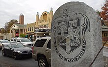
Narberth is a borough in Montgomery County, Pennsylvania. It is one of many neighborhoods on the historic Philadelphia Main Line. The population was 4,282 at the 2010 census.

<span class="mw-page-title-main">Ardmore, Pennsylvania</span> Census-designated place in Pennsylvania, United States

Ardmore is an unincorporated community and census-designated place (CDP) spanning the border between Delaware and Montgomery counties in the U.S. state of Pennsylvania. The population was 12,455 at the time of the 2010 census and had risen to 13,566 in the 2020 census.

<span class="mw-page-title-main">Radnor Township, Pennsylvania</span> Township with home rule in Pennsylvania, United States

Radnor Township, often called simply Radnor, is a first class township with home rule status in Delaware County, Pennsylvania, United States.

<span class="mw-page-title-main">Merion Station, Pennsylvania</span> Unincorporated community in Pennsylvania, United States

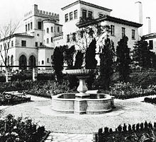
Merion Station, also known as Merion, is an unincorporated community in Montgomery County, Pennsylvania. It borders Philadelphia to its west and is one of the communities that make up the Philadelphia Main Line. Merion Station is part of Lower Merion Township, Montgomery County. The community is known for its grand mansions and for the wealth of its residents.

<span class="mw-page-title-main">Norristown High Speed Line</span> Interurban rapid transit line in Philadelphia

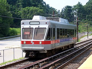
The Norristown High Speed Line (NHSL), the P&W, or Route 100, to be known from 2024 as the M Line, is a 13.4-mile (21.6 km) interurban light rapid transit line operated by SEPTA, running between the 69th Street Transportation Center in Upper Darby and the Norristown Transportation Center in Norristown, Pennsylvania. Originally the Philadelphia and Western Railroad line, the line runs entirely on its own right-of-way. By 2020, the Norristown High Speed Line had an average weekday ridership approaching 11,000 passengers.

<span class="mw-page-title-main">Haverford, Pennsylvania</span> Place in Pennsylvania, United States

Haverford is an unincorporated community located in both Haverford Township in Delaware County, Pennsylvania, United States, and Lower Merion Township in Montgomery County, approximately 3 miles (4.8 km) west of Philadelphia. The Pennsylvania Railroad (PRR) opened Haverford Station in 1880 on their Main Line west out of Broad Street Station in Philadelphia. Haverford sits at milepost 9.17.

<span class="mw-page-title-main">Bala Cynwyd, Pennsylvania</span> Community in Pennsylvania, United States

Bala Cynwyd is a community in Lower Merion Township, Pennsylvania, United States. It is located on the Philadelphia Main Line in Southeastern Pennsylvania and borders the western edge of Philadelphia at U.S. Route 1. The present-day community was originally two separate towns, Bala and Cynwyd, but was united as a singular community largely because the U.S. Post Office, the Bala Cynwyd branch, served both towns using ZIP Code 19004. The community was long known as hyphenated Bala-Cynwyd. Bala and Cynwyd are currently served by separate stations on SEPTA's Cynwyd Line of Regional Rail.

<span class="mw-page-title-main">Radnor, Pennsylvania</span> Locality on the Philadelphia Main Line

Radnor is a community which straddles Montgomery and Delaware Counties, Pennsylvania, United States. It is located approximately 13 miles west of Philadelphia, in the Main Line suburbs. The community was named after Radnor, in Wales.

<span class="mw-page-title-main">Wayne, Pennsylvania</span> Unincorporated community in Delaware County, Pennsylvania, United States

Wayne is an unincorporated community centered in Delaware County, Pennsylvania, United States, on the Main Line, a series of highly affluent Philadelphia suburbs located along the railroad tracks of the Pennsylvania Railroad and one of the wealthiest areas in the nation. While the center of Wayne is in Radnor Township, Wayne extends into both Tredyffrin Township in Chester County and Upper Merion Township in Montgomery County. The center of Wayne was designated the Downtown Wayne Historic District in 2012. Considering the large area served by the Wayne post office, the community may extend slightly into Easttown Township, Chester County, as well.

<span class="mw-page-title-main">Rosemont, Pennsylvania</span> Place in Pennsylvania, United States

Rosemont is a neighborhood and census-designated place that is located in Bryn Mawr, Pennsylvania, United States on the Philadelphia Main Line. Part of Lower Merion Township in Montgomery County, it is best known as the home of Rosemont College. It is the location of the 1894 gothic-revival Anglo-Catholic Church of the Good Shepherd.

<span class="mw-page-title-main">Wynnewood, Pennsylvania</span> Place in Pennsylvania, United States

Wynnewood is a suburban unincorporated community, located west of Philadelphia, straddling Lower Merion Township in Montgomery County, Pennsylvania and Haverford Township in Delaware County, Pennsylvania, United States.

<span class="mw-page-title-main">Villanova, Pennsylvania</span> Village in Pennsylvania

Villanova is a suburb of Philadelphia, Pennsylvania, United States. It straddles Lower Merion Township in Montgomery County and Radnor Township in Delaware County. It is located at the center of the Philadelphia Main Line, a series of Philadelphia suburbs located along the original east–west railroad tracks of the Pennsylvania Railroad. It is served by the SEPTA Paoli/Thorndale Line regional rail train and the Norristown High Speed Line.

<span class="mw-page-title-main">Keystone Corridor</span> High-speed rail corridor in Pennsylvania

The Keystone Corridor is a 349-mile (562 km) railroad corridor between Philadelphia and Pittsburgh, Pennsylvania, that consists of two rail lines: Amtrak and SEPTA's Philadelphia-to-Harrisburg main line, which hosts SEPTA's Paoli/Thorndale Line commuter rail service, and Amtrak's Keystone Service and Pennsylvanian inter-city trains; and the Norfolk Southern Pittsburgh Line. The corridor was originally the Main Line of the Pennsylvania Railroad.

<span class="mw-page-title-main">Haverford station (SEPTA Regional Rail)</span>

Haverford station is a SEPTA Regional Rail station in Haverford, Pennsylvania. It is served by most Paoli/Thorndale Line trains with the exception of a few express runs, and is located on Haverford Station Road. The station was originally built by the Pennsylvania Railroad.

<span class="mw-page-title-main">Penn Valley, Pennsylvania</span> Unincorporated community in Pennsylvania, United States

Penn Valley is an unincorporated community located within Lower Merion Township, Pennsylvania, United States. Penn Valley residents share a zip code with Merion, Narberth, or Wynnewood because the community does not have its own post office. However, Penn Valley is a distinct community whose civic association demarcates its boundaries with iconic signs featuring William Penn and a farmhouse in blue or red on white, dating from 1930.

<span class="mw-page-title-main">Paoli/Thorndale Line</span> SEPTA Regional Rail service from Philadelphia to Thorndale

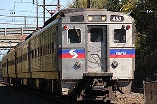
The Paoli/Thorndale Line, commonly known as the Main Line, is a SEPTA Regional Rail service running from Center City Philadelphia through Montgomery County and Delaware County to Thorndale in Chester County. It operates along the far eastern leg of Amtrak's Philadelphia to Harrisburg Main Line, which in turn was once the Main Line of the Pennsylvania Railroad and is now part of the Keystone Corridor, a federally-designated high-speed rail corridor.

References

  1. "Top-Earning Towns". Money.cnn.com. July 14, 2010. Retrieved July 23, 2012.
  2. "America's Richest Zip Codes 2011". Archived from the original on January 7, 2012.
  3. "15 Hottest Towns in Philadelphia's Western Suburbs". Main Line Today. February 14, 2019. Retrieved October 31, 2021.
  4. D'Apéry, Tello J. (1936). Overbrook Farms. Its historical background, growth and community life (PDF). Philadelphia: Magee Press. p. 4.
  5. Fodor's Philadelphia & the Pennsylvania Dutch Country, 16th Edition (Fodor's Gold Guides), New York, p. 106.
  6. 1 2 Jim Waltzer (January 2008). "Where the Tracks Lie". Main Line Today. Retrieved December 4, 2018.
  7. 1900 census: Tredyffrin, Chester, Pennsylvania
  8. 1900 census: Lower Merion, Montgomery, Pennsylvania
  9. "TEHS - Quarterly Archives".
  10. US Census, 1920, Enumeration District 78, Tredyffrin, Eastern Precinct, Chester County, Pennsylvania
  11. Philly NRHS – PRR History
  12. "Beyond Philly: The Main Line". National Geographic Society . June 10, 2013. Archived from the original on January 18, 2019.
  13. "Discovering the entire hidden history of the Main Line – E-Scholium".
  14. "1887 Edition".
  15. "1908 Edition".
  16. SEPTA Archived 2008-11-13 at the Wayback Machine
  17. SEPTA Route 105 Schedule
  18. SEPTA Route 106 Schedule
  19. "Norristown High Speed Line". SEPTA. Retrieved November 18, 2019.
  20. Appleford Estate, history Archived 2009-08-08 at the Wayback Machine
  21. Bryn Mawr Film Institute Archived 2009-06-16 at the Wayback Machine
  22. FISHER, CHRISTINE (July 12, 2013). "Staycation: Cynwyd Heritage Trail". www.planphilly.com. Retrieved November 20, 2016.
  23. Harriton House history
  24. "Radnor Hunt - About Us". www.radnorhunt.org. Retrieved January 14, 2019.
  25. "Book Review of Chimamanda Adichie's Americanah".
  26. Alter, Alexandra (March 29, 2016). "Jessica Knoll Reveals the Rape Behind Her Novel, 'Luckiest Girl Alive'". The New York Times. ISSN   0362-4331 . Retrieved July 1, 2016.
  27. Hoffman, Alice (September 23, 2011). "'All My Children': Farewell to Pine Valley". Los Angeles Times . Retrieved January 26, 2017.
  28. Bennett, Kitty. "Where Are They Now? Julie and David Eisenhower", AARP Bulletin, December 22, 2010. p. 1.

Further reading