Northampton County, Pennsylvania

Last updated

Northampton County
Northampton County, Pennsylvania, Courthouse 1905.jpg
A 1905 illustration of Northampton County Courthouse in Easton
Northampton County, Pennsylvania.gif
Northampton County, Pennsylvania seal.png
Map of Pennsylvania highlighting Northampton County.svg
Location within the U.S. state of Pennsylvania
Pennsylvania in United States.svg
Pennsylvania's location within the U.S.
Coordinates: 40°45′N75°19′W / 40.75°N 75.31°W / 40.75; -75.31
CountryFlag of the United States.svg United States
StateFlag of Pennsylvania.svg  Pennsylvania
FoundedMarch 11, 1752
Named for Northamptonshire
Seat Easton
Largest city Bethlehem
Area
  Total377 sq mi (980 km2)
  Land370 sq mi (1,000 km2)
  Water7.7 sq mi (20 km2)  2.0%
Population
 (2020)
  Total312,951
  Density830/sq mi (320/km2)
Time zone UTC−5 (Eastern)
  Summer (DST) UTC−4 (EDT)
Congressional district 7th
Website www.northamptoncounty.org

Northampton County is a county in the Commonwealth of Pennsylvania, United States. As of the 2020 census, the population was 312,951. [1] Its county seat is Easton. [2] The county was formed in 1752 from parts of Bucks County. Its namesake was the county of Northamptonshire in England, and the county seat of Easton was named for Easton Neston, a country house in Northamptonshire.

Contents

Northampton County and Lehigh County to its west combine to form the eastern Pennsylvania region known as the Lehigh Valley; Lehigh County, with a population of 374,557 as of the 2020 U.S. census, is the more highly populated of the two counties. Both counties are part of the Philadelphia media market, the fourth-largest in the nation.

Northampton County has historically been a national leader in heavy manufacturing, especially of cement, steel, and other industrial products. Atlas Portland Cement Company, the world's largest cement manufacturer from 1895 until 1982, was based in Northampton in the county. [3] Bethlehem Steel, the world's second-largest manufacturer of steel for most of the 20th century, was based in Bethlehem, the county's most populous city, prior to its dissolution in 2003.

Northampton County borders Carbon County and the Poconos to its north, Lehigh County to its west, Bucks County to its south, and the Delaware River and New Jersey to its east. The Lehigh River, a 109-mile-long (175 km) tributary of the Delaware River, flows through the county.

Geography

The Easton-Phillipsburg Toll Bridge, which connects Easton in Northampton County with Phillipsburg in northwestern New Jersey in the Lehigh Valley, in October 2009 Easton-pburg-toll-bridge.jpg
The Easton–Phillipsburg Toll Bridge, which connects Easton in Northampton County with Phillipsburg in northwestern New Jersey in the Lehigh Valley, in October 2009

According to the U.S. Census Bureau, the county has a total area of 377 square miles (980 km2), of which 370 square miles (960 km2) is land and 7.7 square miles (20 km2) (2.0%) is water. [4] The climate is humid continental (mostly Dfa with a little Dfb in higher northern areas) and the hardiness zone is 7a except in the northern iier where it is 6b. Average monthly temperatures in downtown Bethlehem average from 29.1 °F in January to 74.1 °F in July, while in Wind Gap they average from 27.0 °F in January to 71.7 °F in July. [5]

Adjacent counties

National protected areas

Demographics

Historical population
CensusPop.Note
1790 24,220
1800 30,06224.1%
1810 38,14526.9%
1820 31,765−16.7%
1830 39,48224.3%
1840 40,9963.8%
1850 40,235−1.9%
1860 47,90419.1%
1870 61,43228.2%
1880 70,31214.5%
1890 84,22019.8%
1900 99,68718.4%
1910 127,66728.1%
1920 153,50620.2%
1930 169,30410.3%
1940 168,959−0.2%
1950 185,2439.6%
1960 201,4128.7%
1970 214,3686.4%
1980 225,4185.2%
1990 247,1059.6%
2000 267,0668.1%
2010 297,73511.5%
2020 312,9515.1%
U.S. Decennial Census [6]
1790-1960 [7] 1900-1990 [8]
1990-2000 [9] 2010-2019 [1]

As of the 2020 census, the county's population was 312,951, reflecting growth of 5.1% over 2010. [1] As of the 2010 census, the county was 81.0% White Non-Hispanic, 5.0% Black or African American, 0.2% Native American or Alaskan Native, 2.4% Asian, 0.0% Native Hawaiian, 2.2% were two or more races, and 3.8% were some other race. 10.5% of the population were of Hispanic or Latino ancestry.

2020 census

Northampton County Racial Composition [10]
RaceNum.Perc.
White (NH)228,37373%
Black or African American (NH)17,4295.6%
Native American (NH)2510.08%
Asian (NH)9,8923.2%
Pacific Islander (NH)750.02%
Other/Mixed (NH)12,3344%
Hispanic or Latino 44,59714.25%

Government

Northampton is one of the seven counties in Pennsylvania which has adopted a home rule charter. Voters elect a county executive, a nine-person county council, a county controller, and a county district attorney. The executive, controller, district attorney, and five of the nine council members are elected at large by all voters in the county. The other four members of the county council are elected from single-member districts, which they represent. This weighted structure of county government favors the majority of voters. The county's row officers are nominated by the county executive and approved by county council.

Politics

United States presidential election results for Northampton County, Pennsylvania [11]
Year Republican Democratic Third party
No.%No.%No.%
2020 83,85448.92%85,08749.64%2,4581.43%
2016 71,73649.62%66,27245.84%6,5584.54%
2012 61,44646.89%67,60651.59%1,9921.52%
2008 58,55143.07%75,25555.35%2,1481.58%
2004 62,10248.96%63,44650.02%1,3011.03%
2000 47,39645.27%53,09750.72%4,1974.01%
1996 35,72639.26%43,95948.31%11,31712.44%
1992 34,42935.30%42,20343.27%20,89321.42%
1988 42,74851.52%39,26447.32%9661.16%
1984 44,64853.49%37,97945.50%8401.01%
1980 35,78747.07%31,92041.98%8,33010.96%
1976 32,92642.78%42,51455.24%1,5211.98%
1972 41,82256.30%32,33543.53%1240.17%
1968 32,03341.00%42,55454.47%3,5434.53%
1964 21,04826.15%58,81873.08%6190.77%
1960 40,68349.43%41,55250.48%710.09%
1956 43,37555.83%33,74943.44%5730.74%
1952 39,13150.99%36,99348.21%6140.80%
1948 27,03043.95%33,20953.99%1,2652.06%
1944 26,64344.76%32,58454.75%2920.49%
1940 25,38543.06%33,30456.49%2690.46%
1936 22,82737.34%36,87160.31%1,4382.35%
1932 20,77945.04%24,00952.04%1,3452.92%
1928 37,40371.14%14,76828.09%4040.77%
1924 20,45958.42%11,45932.72%3,1048.86%
1920 14,22758.78%9,08637.54%8913.68%
1916 9,61044.37%11,00050.78%1,0504.85%
1912 3,89317.91%10,32547.50%7,51834.59%
1908 10,85746.91%11,36549.10%9233.99%
1904 11,03951.21%9,91445.99%6042.80%
1900 9,84945.14%11,41252.31%5562.55%
1896 9,76247.59%10,03248.91%7173.50%
1892 6,89239.21%10,32058.71%3672.09%
1888 6,78539.67%10,02758.63%2911.70%
1884 6,32739.44%9,49159.16%2241.40%
1880 5,96137.90%9,65361.37%1140.72%

As of January 8, 2024, there were 219,719 registered voters in Northampton County

Northampton County is considered one of Pennsylvania's "swing counties," with statewide winners carrying it in most cases. [12]

Voting machine problems

2019 election

In November 2019, municipal elections were in Pennsylvania in November 2019, and the county's result tabulations were plagued with problems caused by newly purchased voting machines, known as ExpressVoteXL, which were manufactured and sold to the county by Election Systems & Software (ES&S), an Omaha, Nebraska-based company, as representing a luxury one-stop voting system.

According to The New York Times and other media, a few minutes after polls closed in the county in 2019, panic began to spread through the county's election offices as it became evident that vote totals in one judge's race showed one candidate, Abe Kassis, a Democrat, had received just 164 votes out of 55,000 ballots across more than the 100 precincts in the county; Some precinct machines reported zero votes for him. [13]

The ES&S voting system, which is used in other Pennsylvania jurisdictions, features a touch screen with a paper ballot backup. County officials ultimately calculated results by counting paper ballots, which showed Kassis actually won the election by 1,054 votes, according to unofficial results that were announced on November 6. The election results were later certified following a canvass and audit, and no challenges to the results were filed. [14]

2023 election

On November 7, 2023, ExpressVoteXL machines again malfunctioned in calculating votes for Superior Court of Pennsylvania judges with the machines switching "yes" and "no" votes on the summary display of votes on whether the judges should be retained. The county's director of administration, Charles Dertinger, attributed the problem to the summary display and not the actual ballots. [15]

County executives

Northampton County executives
NamePartyTerm startTerm end
Glenn F. Reibman Democratic 19982006
John StoffaDemocratic20062014
John Brown Republican 20142018
Lamont McClure Democratic 2018Incumbent

State representatives [16]

State senators [16]

United States House of Representatives

United States Senate

Education

The Alumni Memorial Building at Lehigh University in Bethlehem in August 2005 Lehigh University Alumni Building.jpg
The Alumni Memorial Building at Lehigh University in Bethlehem in August 2005

Colleges and universities

Public school districts

Freedom High School, one of two large public high schools in the Bethlehem Area School District, in November 2008 Freedom High School Gym (Bethlehem, Pennsylvania - 2008).jpg
Freedom High School, one of two large public high schools in the Bethlehem Area School District, in November 2008

Public charter schools

Private high schools

Transportation

Lehigh Valley International Airport, the fourth-busiest passenger airport in Pennsylvania, located in Hanover Township ABE terminal (2).JPG
Lehigh Valley International Airport, the fourth-busiest passenger airport in Pennsylvania, located in Hanover Township

Air transportation

Air transport to and from Northampton County is available through Lehigh Valley International Airport ( IATA : ABE, ICAO : KABE) in Hanover Township, which is locatedapproximately 4 miles (6.4 km) northwest of Bethlehem and 11 miles (18 km) west-southwest of Easton.

Bus transportation

Public bus service in Northampton County is available through LANta. A shuttle bus service called the Bethlehem Loop provides public transportation services in Bethlehem. NJ Transit provides service from Easton's Centre Square to the Phillipsburg area.

Major highways

I-78 eastbound in Northampton County 2022-09-27 11 13 21 View east along Interstate 78 from the overpass for Applebutter Road in Lower Saucon Township, Northampton County, Pennsylvania.jpg
I-78 eastbound in Northampton County

Telecommunications

Northampton County was once served only by the 215 area code from 1947 (when the North American Numbering Plan of the Bell System went into effect) until 1994. With the county's growing population, however, Northampton County was afforded area code 610 in 1994. Today, Northampton County is covered by 610 except for the Portland exchange which uses 570. An overlay area code, 484, was added to the 610 service area in 1999. [17] A plan to introduce area code 835 as an additional overlay was rescinded in 2001. [18]

Recreation

There are two Pennsylvania state parks in Northampton County:

Communities

Easton, the county seat of Northampton County, in May 2009 Easton Skyline.jpg
Easton, the county seat of Northampton County, in May 2009
Allen Township, in November 2011 Allen Twp Valley View.jpg
Allen Township, in November 2011
Bangor, in October 2015 Bangoria.JPG
Bangor, in October 2015
Dery Silk Mill in Catasauqua, in October 2012 Dery Silk Mill Lehigh Co PA.JPG
Dery Silk Mill in Catasauqua, in October 2012
East Allen Township, in February 2013 Red Barn.jpg
East Allen Township, in February 2013
Tatamy at sundown, in November 2021 7th and Main Street intersection in Tatamy PA during sundown.jpg
Tatamy at sundown, in November 2021
Lake Poco Dam in Upper Mount Bethel Township, in November 2011 Flickr - Nicholas T - No-Name Lake.jpg
Lake Poco Dam in Upper Mount Bethel Township, in November 2011
The Delaware River running through Forks Township, in May 2012 Delaware River view from Forks PA looking north.jpg
The Delaware River running through Forks Township, in May 2012

The following cities, boroughs, and townships are located in Northampton County:

Cities

Boroughs

Townships

Census-designated places

Census-designated places are unincorporated communities designated by the U.S. Census Bureau for the purposes of compiling demographic data. They are not actual jurisdictions under Pennsylvania law.

Other unincorporated places

Population ranking

The population ranking of the following table is based on the 2010 census of Northampton County. [19]

county seat

RankCity/borough/township/etc.Municipal typePopulation (2010 Census)
1 Bethlehem (partially in Lehigh County )City74,982
2 Easton City26,800
3 Bethlehem Township Township23,730
4 Palmer Township Township20,691
5 Forks Township Township14,721
6 Hanover Township Township10,866
7 Lower Saucon Township Township10,772
8 Lehigh Township Township10,527
9 Northampton Borough9,926
10 Moore Township Township9,198
11 Bushkill Township Township8,178
12 Wilson Borough7,896
13 Middletown CDP7,441
14 Upper Mount Bethel Township Township6,706
15 Upper Nazareth Township Township6,231
16 Plainfield Township Township6,138
17 Hellertown Borough5,898
18 Williams Township Township5,884
19 Nazareth Borough5,746
20 Lower Nazareth Township Township5,674
21 Bangor Borough5,273
22 Washington Township Township5,122
23 East Allen Township Township4,930
24 Allen Township Township4,269
25 Palmer Heights CDP3,762
26 Pen Argyl Borough3,595
27 Eastlawn Gardens CDP3,307
28 Lower Mount Bethel Township Township3,101
29 North Catasauqua Borough2,849
30 Wind Gap Borough2,720
31 Bath Borough2,693
32 Freemansburg Borough2,636
33 Old Orchard CDP2,434
34 Walnutport Borough2,070
35 Cherryville CDP1,580
36 Roseto Borough1,567
37 Belfast CDP1,257
38 West Easton Borough1,257
39 Tatamy Borough1,203
40 East Bangor Borough1,172
41 Raubsville CDP1,088
42 Stockertown Borough927
43 Martins Creek CDP631
44 Ackermanville CDP610
45 Portland Borough519
46 Glendon Borough440
47 Chapman Borough199

Notable people

Related Research Articles

<span class="mw-page-title-main">Lehigh County, Pennsylvania</span> County in Pennsylvania, United States

Lehigh County is a county in the Commonwealth of Pennsylvania. As of the 2020 census, the county's population was 374,557. Its county seat is Allentown, the state's third-largest city after Philadelphia and Pittsburgh.

<span class="mw-page-title-main">Upper Saucon Township, Pennsylvania</span> Township in Pennsylvania, United States

Upper Saucon Township is a township in Lehigh County, Pennsylvania, United States. It is part of the Lehigh Valley metropolitan area, which had a population of 861,899 and was the 68th-most populous metropolitan area in the U.S. as of the 2020 census. The township had a population of 16,973 as of the 2020 census.

<span class="mw-page-title-main">Bethlehem Township, Pennsylvania</span> Place in Pennsylvania, United States

Bethlehem Township is a township in Northampton County, Pennsylvania, United States. The population of Bethlehem Township was 23,730 at the 2010 census. It is a suburb of Bethlehem and is part of the Lehigh Valley metropolitan statistical area, which had a population of 861,899 and was the 68th-most populous metropolitan area in the U.S. as of the 2020 census.

<span class="mw-page-title-main">Easton, Pennsylvania</span> City in Pennsylvania, United States

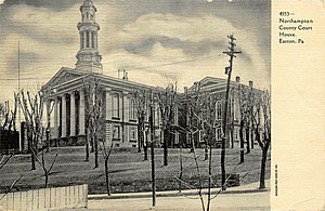
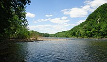
Easton is a city in, and the county seat of, Northampton County, Pennsylvania, United States. The city's population was 28,127 as of the 2020 census. Easton is located at the confluence of the Lehigh River, a 109-mile-long (175 km) river that joins the Delaware River in Easton and serves as the city's eastern geographic boundary with Phillipsburg, New Jersey.

<span class="mw-page-title-main">Hellertown, Pennsylvania</span> Place in Pennsylvania, United States

Hellertown is a borough in Northampton County, Pennsylvania. Its population was 6,131 at the 2020 census. Hellertown is part of the Lehigh Valley metropolitan area, which had a population of 861,899 and was the 68th-most populous metropolitan area in the U.S. as of 2020.

<span class="mw-page-title-main">Lower Saucon Township, Pennsylvania</span> Place in Pennsylvania, United States

Lower Saucon Township is a township in Northampton County, Pennsylvania, United States. The township's population was 10,772 as of the 2010 census. The township is part of the Lehigh Valley metropolitan area, which had a population of 861,899 and was the 68th-most populous metropolitan area in the U.S. as of the 2020 census.

<span class="mw-page-title-main">Moore Township, Pennsylvania</span> Place in Pennsylvania, United States

Moore Township is a township in Northampton County, Pennsylvania, United States. The population of Moore Township was 9,198 at the 2010 census. The township is located in the Lehigh Valley, which had a population of 861,899 and was the 68th-most populous metropolitan area in the U.S. as of the 2020 census.

<span class="mw-page-title-main">Palmer Township, Pennsylvania</span> Second Class Township in Pennsylvania, United States

Palmer Township is a township in Northampton County, Pennsylvania, United States. The population of Palmer Township was 22,317 at the 2020 census. It is the eight-largest municipality in the Lehigh Valley metropolitan area, which had a population of 861,899 and was the 68th-most populous metropolitan area in the U.S. as of the 2020 census.

<span class="mw-page-title-main">Bethlehem, Pennsylvania</span> City in Pennsylvania, United States

Bethlehem is a city in Northampton and Lehigh Counties in the Lehigh Valley region of eastern Pennsylvania, United States. As of the 2020 census, Bethlehem had a total population of 75,781, making it the second-largest city in the Lehigh Valley after Allentown and the seventh-largest city in the state. Among its total population as of 2020, 55,639 were in Northampton County and 19,343 were in Lehigh County. The city is located along the Lehigh River, a 109-mile-long (175 km) tributary of the Delaware River.

<span class="mw-page-title-main">Index of Pennsylvania-related articles</span>

The following is an alphabetical list of articles on people, places, and things related to Pennsylvania in the United States.

<span class="mw-page-title-main">Lehigh Valley</span> Metropolitan Statistical Area in the United States

The Lehigh Valley is a geographic and metropolitan region formed by the Lehigh River in Lehigh and Northampton counties in eastern Pennsylvania. It is a component valley of the Great Appalachian Valley bounded to its north by Blue Mountain, to its south by South Mountain, to its west by Lebanon Valley, and to its east by the Delaware River and Warren County, New Jersey. The Lehigh Valley is about 40 miles (64 km) long and 20 miles (32 km) wide. The Lehigh Valley's largest city is Allentown, the third-largest city in Pennsylvania and the county seat of Lehigh County, with a population of 125,845 residents as of the 2020 census.

<span class="mw-page-title-main">Area codes 610, 484, and 835</span> Telephone area codes in Pennsylvania, United States

Area codes 610, 484, and 835 are telephone area codes in the North American Numbering Plan (NANP) for the eastern and southeastern regions of Pennsylvania. The numbering plan area (NPA) includes regions to the west of Philadelphia and the cities Allentown, Bethlehem, and Reading. It includes much of the Delaware Valley, including almost all of Delaware County, most of the Philadelphia Main Line, and all of the Lehigh Valley.

<span class="mw-page-title-main">Minsi Trails Council</span>

Minsi Trails Council is a council of the Boy Scouts of America that serves Scouts in the Lehigh Valley and the Pocono Mountains regions of eastern Pennsylvania and western New Jersey. In Pennsylvania, the council serves five counties: Lehigh, Northampton, Monroe, Carbon, and Luzerne. In New Jersey, it serves Warren County.

<span class="mw-page-title-main">Pennsylvania Route 378</span> State highway in Pennsylvania, US

Pennsylvania Route 378 (PA 378) is a north-to-south road in Lehigh and Northampton counties in the Lehigh Valley region of the U.S. state of Pennsylvania. The southern terminus is at PA 309 in Center Valley. Its northern terminus is at U.S. Route 22 (US 22) in Bethlehem. The route heads north from PA 309 as a two-lane undivided road through Upper Saucon Township and Lower Saucon Township before crossing South Mountain into Bethlehem. Here, PA 378 follows city streets through Bethlehem's South Side, intersecting the northern terminus of PA 412. The route becomes a four-lane freeway and crosses the Lehigh River before continuing north to US 22. PA 378 is the only highway from US 22 to Center City Bethlehem, and a quick route for visitors traveling to the Wind Creek Bethlehem casino resort on the city's South Side.

The Lehigh Valley Interscholastic Athletic Conference, known informally as the Lehigh Valley Conference or LVC, was an athletic conference consisting of 12 of the largest high schools from Lehigh and Northampton counties in the Lehigh Valley region of Pennsylvania. It was part of District XI of the Pennsylvania Interscholastic Athletic Association (PIAA). In 2014, its teams were mostly assimilated into the Eastern Pennsylvania Conference, an even larger 18-team league of the largest high schools in the Lehigh Valley and Pocono Mountains regions of eastern and northeastern Pennsylvania.

Pennsylvania State Senate District 18 includes parts of Lehigh and Northampton counties in the Lehigh Valley region of eastern Pennsylvania. It is currently represented by Democrat Lisa Boscola.

<span class="mw-page-title-main">Colonial League</span>

The Colonial League is an athletic conference consisting of 14 high schools mostly from the Lehigh Valley portion of eastern Pennsylvania. It is part of District XI of the Pennsylvania Interscholastic Athletic Association. The Colonial League is designed for mid and small-size schools in the Lehigh Valley. The largest 18 schools in the Lehigh Valley and Pocono region compete in the Eastern Pennsylvania Conference, one of the premiere athletic divisions in the nation.

District 11 of the Pennsylvania Interscholastic Athletic Association (PIAA) is an interscholastic athletic association in eastern Pennsylvania.

<span class="mw-page-title-main">Ackermanville, Pennsylvania</span> Census-designated place in Pennsylvania, United States

Ackermanville is a census-designated place located on PA Route 191 in Washington Township, Northampton County, Pennsylvania, United States. As of the 2022 American Community Survey, the village's population was 280. Ackermanville is part of the Lehigh Valley metropolitan area, which had a population of 861,899 and was the 68th-most populous metropolitan area in the U.S. as of the 2020 census. It was named for the Ackerman family.

The Slate Belt is a geographic region in Northampton County, Pennsylvania that is typically described as including Bangor, Wind Gap, Pen Argyl, and Portland. The region is named for the historical prevalence of slate quarrying in the area.

References

    1. 1 2 3 "State & County QuickFacts". United States Census Bureau. Archived from the original on June 6, 2011. Retrieved November 20, 2013.
    2. "Find a County". National Association of Counties. Archived from the original on May 31, 2011. Retrieved June 7, 2011.
    3. Duck, Michael (May 20, 2006). "Cement museum nurtures nostalgia in Pennsylvania". tribunedigital-chicagotribune. Chicago Tribune.
    4. "2010 Census Gazetteer Files". United States Census Bureau. August 22, 2012. Retrieved March 9, 2015.
    5. "PRISM Climate Group at Oregon State University".
    6. "U.S. Decennial Census". United States Census Bureau. Retrieved March 9, 2015.
    7. "Historical Census Browser". University of Virginia Library. Archived from the original on August 11, 2012. Retrieved March 9, 2015.
    8. Forstall, Richard L., ed. (March 24, 1995). "Population of Counties by Decennial Census: 1900 to 1990". United States Census Bureau. Archived from the original on March 20, 2015. Retrieved March 9, 2015.
    9. "Census 2000 PHC-T-4. Ranking Tables for Counties: 1990 and 2000" (PDF). United States Census Bureau. April 2, 2001. Archived (PDF) from the original on December 18, 2014. Retrieved March 9, 2015.
    10. "P2 HISPANIC OR LATINO, AND NOT HISPANIC OR LATINO BY RACE – 2020: DEC Redistricting Data (PL 94-171) – Northampton County, Pennsylvania".
    11. Leip, David. "Dave Leip's Atlas of U.S. Presidential Elections". uselectionatlas.org. Archived from the original on March 23, 2018.
    12. "The bellwethers: What do voters in eastern PA know that the rest don't?". PennLive.com. Archived from the original on September 17, 2016. Retrieved September 13, 2016.
    13. "A Pennsylvania County’s Election Day Nightmare Underscores Voting Machine Concerns," The New York Times, November 30, 2019.
    14. "Pennsylvania says election went well but Republicans disagree; both following Northampton County problems," The Morning Call, November 6, 2019
    15. "Pennsylvania county promises accurate tally after clerical error appears to flip votes for judges" The Associated Press, November 7, 2023
    16. 1 2 Center, Legislativate Data Processing. "Find Your Legislator". The official website for the Pennsylvania General Assembly. Archived from the original on April 22, 2017. Retrieved April 21, 2017.
    17. "NANP-Overlay of 610 (Pennsylvania) Numbering Plan Area (NPA) with 484 NPA" (PDF). Archived (PDF) from the original on November 26, 2010. (359 KB)
    18. "PA 835 Implementation for 484/610 NPA Rescinded – 835 NPA Code Reclaimed" (PDF). Archived (PDF) from the original on November 26, 2010. (20.8 KB)
    19. CNMP, US Census Bureau. "This site has been redesigned and relocated. - U.S. Census Bureau". www.census.gov. Retrieved May 1, 2018.

    Further reading

    40°45′N75°19′W / 40.75°N 75.31°W / 40.75; -75.31