Elk County, Pennsylvania

Last updated

Elk County
Elk County Courthouse.jpg
Elk County Courthouse in Ridgway, Pennsylvania
Flag of Elk County, Pennsylvania.png
Logo of Elk County, Pennsylvania.png
Map of Pennsylvania highlighting Elk County.svg
Location within the U.S. state of Pennsylvania
Pennsylvania in United States.svg
Pennsylvania's location within the U.S.
Coordinates: 41°25′N78°39′W / 41.42°N 78.65°W / 41.42; -78.65
CountryFlag of the United States.svg United States
StateFlag of Pennsylvania.svg  Pennsylvania
FoundedApril 18, 1843
Named for Eastern elk
Seat Ridgway
Largest city St. Marys
Area
  Total832 sq mi (2,150 km2)
  Land827 sq mi (2,140 km2)
  Water4.9 sq mi (13 km2)  0.6%
Population
 (2020)
  Total30,990 [1]
  Density37.5/sq mi (14.5/km2)
Time zone UTC−5 (Eastern)
  Summer (DST) UTC−4 (EDT)
Congressional district 15th
Website www.co.elk.pa.us

Elk County is a county in the Commonwealth of Pennsylvania. As of the 2020 United States census, the population was 30,990. [2] Its county seat is Ridgway. [3] The county was created on April 18, 1843, from parts of Jefferson, Clearfield, and McKean Counties. Elk County is named for the now-extinct eastern elk (Cervus canadensis) that historically inhabited the region. The county is part of the North Central Pennsylvania region of the state. [lower-alpha 1]

Contents

The county is notable for having one of the highest concentrations of Roman Catholics in the United States, with 69% of the county's residents identifying as Catholic.

Geography

Elk County consists of low rolling hills, carved by frequent drainages and heavily wooded.

According to the United States Census Bureau, the county has a total area of 832 square miles (2,150 km2), of which 827 square miles (2,140 km2) is land and 4.9 square miles (13 km2) (0.6%) is water. [4] Elk has a warm-summer humid continental climate (Dfb) and average monthly temperatures in Ridgway range from 23.2 °F in January to 67.4 °F in July, while in Saint Marys they range from 22.6 °F in January to 66.8 °F in July. [5]

Adjacent counties

National protected area

State protected areas

Major highways

Demographics

As of the 2020 United States Census, [6] there were 30,990 people and 14,215 households. The population density was 38 people per square mile (15 people/km2). There were 16,855 housing units at an average density of 20 units per square mile (7.7/km2). The racial makeup of the county was 97.9% White, 0.5% Black or African American, 0.2% Native American, 0.4% Asian, and 1.0% from two or more races. 0.8% of the population were Hispanic or Latino of any race. 46.6% were of German, 17.6% Italian, 15.2% Irish, 7.3% Polish, 6.7% English, 6.3% American, and 5.2% Swedish.

Historical population
CensusPop.Note
1850 3,531
1860 5,91567.5%
1870 8,48843.5%
1880 12,80050.8%
1890 22,23973.7%
1900 32,90348.0%
1910 35,8719.0%
1920 34,981−2.5%
1930 33,431−4.4%
1940 34,4433.0%
1950 34,5030.2%
1960 37,3288.2%
1970 37,7701.2%
1980 38,3381.5%
1990 34,878−9.0%
2000 35,1110.7%
2010 31,946−9.0%
2020 30,990−3.0%
[7]
Population pyramid USA Elk County, Pennsylvania age pyramid.svg
Population pyramid

There were 14,124 households, out of which 31.00% had children under the age of 18 living with them, 56.00% were married couples living together, 8.70% had a female householder with no husband present, and 31.00% were non-families. 27.30% of all households were made up of individuals, and 13.60% had someone living alone who was 65 years of age or older. The average household size was 2.45 and the average family size was 2.99.

The county population contained 24.00% under the age of 18, 6.80% from 18 to 24, 28.60% from 25 to 44, 23.30% from 45 to 64, and 17.30% who were 65 years of age or older. The median age was 39 years. For every 100 females there were 98.00 males. For every 100 females aged 18 and over, there were 95.30 males.

Elk County has one of the highest concentrations of Roman Catholics in the United States. As of 2010, nearly 70% of the county's residents identified as Catholic.

2020 census

Elk County Racial Composition [8]
RaceNum.Perc.
White (NH)30,33997.9%
Black or African American (NH)1550.5%
Native American (NH)620.2%
Asian (NH)1240.4%
Other/Mixed (NH)3101.0%
Hispanic or Latino 2790.9%

Economy

As of the 2021 ACS 5-Year Estimates, Elk County's largest industry and source of employment is manufacturing, with the second largest being educational services, healthcare, and social services.

Government and politics

United States presidential election results for Elk County, Pennsylvania [9]
Year Republican Democratic Third party
No.%No.%No.%
2020 12,14071.64%4,52226.68%2841.68%
2016 10,02568.91%3,85326.49%6694.60%
2012 7,57957.08%5,46341.14%2371.78%
2008 6,67646.48%7,29050.76%3962.76%
2004 7,87254.10%6,60245.37%760.52%
2000 7,34754.10%5,75442.37%4793.53%
1996 4,88937.57%5,74944.18%2,37518.25%
1992 4,90835.48%5,01636.26%3,90828.25%
1988 6,73752.86%5,87946.13%1281.00%
1984 8,47060.47%5,48639.17%510.36%
1980 7,17552.49%5,89843.15%5964.36%
1976 6,15946.98%6,71351.21%2371.81%
1972 7,90061.20%4,71036.49%2982.31%
1968 6,19344.09%6,88649.02%9676.88%
1964 4,35429.36%10,45570.51%190.13%
1960 7,15545.96%8,39853.95%140.09%
1956 8,94761.84%5,49838.00%230.16%
1952 7,70254.26%6,44845.42%450.32%
1948 5,14848.98%5,36351.02%00.00%
1944 5,64547.80%6,09751.63%670.57%
1940 6,94949.99%6,92049.78%310.22%
1936 5,48935.12%9,03557.80%1,1077.08%
1932 5,79746.39%6,46151.70%2391.91%
1928 5,23440.23%7,70559.23%700.54%
1924 6,62670.85%1,37014.65%1,35614.50%
1920 5,26766.14%2,09326.28%6047.58%
1916 2,82952.34%2,18640.44%3907.22%
1912 60310.50%2,05735.82%3,08253.67%
1908 2,99151.52%2,53143.60%2834.88%
1904 3,82055.25%2,85741.32%2373.43%
1900 3,25450.06%3,10547.77%1412.17%
1896 2,80749.57%2,71747.98%1392.45%
1892 1,43838.94%2,12657.57%1293.49%
1888 1,32141.09%1,82456.73%702.18%

Chart of Voter Registration

   Republican (57.01%)
   Democratic (31.26%)
   Independent (7.59%)
   Other Parties (4.14%)

Voter demographics

As of April 29, 2024, there are 20,033 registered voters in Elk County. [10]

Elk County has tended to be politically competitive in statewide and national elections. The county has frequently voted with the eventual winner of national elections, from 1920 to 2008, except for 1928 when Al Smith carried the county with nearly 60% of the vote over winner Herbert Hoover, in 1940 when Wendell Willkie carried the county with a very slim margin of 29 votes over incumbent Franklin D. Roosevelt and in 1968, when Hubert Humphrey won it over eventual winner Richard Nixon.

County commissioners

  • Joseph Daghir, Republican
  • M. Fritz Lecker, Republican
  • Matthew G. Quesenberry, Democrat

Other county offices

  • Clerk of Courts and Prothonotary, Susanne Schneider, Republican
  • Coroner, Michelle Muccio, Republican
  • District Attorney, Beau Grove, Republican
  • Register of Wills and Recorder of Deeds, Lee Neureiter, Republican
  • Sheriff, Todd Caltagarone, Republican
  • Treasurer, Peggy Schneider, Republican
  • Auditors, Sandra A. Caltagarone, Republican; Jean Zore, Republican; Siobhan Voss, Democrat

State representative

State senator

United States representative

United States senators

Education

Map of Elk County, Pennsylvania School Districts Map of Elk County Pennsylvania School Districts.png
Map of Elk County, Pennsylvania School Districts

Community education center

The Community Education Center of Elk and Cameron Counties (or CEC) provides credit, non-credit, and enrichment programs.

Public school districts

Private schools

  • Elk County Catholic High School
  • St Boniface School - Kersey
  • St Leo School - Ridgway
  • St Marys Catholic Elementary School = Saint Marys
  • St Marys Catholic Middle School = Saint Marys
  • North Central Workforce Investment Board - Ridgway
  • Anne Forbes Nursery School - Ridgway

Libraries

  • Elk County Library System - Saint Marys
  • Johnsonburg Public Library - Johnsonburg
  • Ridgway Free Public Library - Ridgway
  • Saint Marys Public Library - Saint Marys
  • Tri State Coll Library Co-Op - Rosemont
  • Wilcox Public Library - Wilcox

Communities

Elk County boroughs and municipalities Map of Elk County Municipalities shaded in red and blue.jpg
Elk County boroughs and municipalities

Under Pennsylvania law, there are four types of incorporated municipalities: cities, boroughs, townships, and, in at most two cases, towns. The following cities, boroughs, and townships are located in Elk County:

City

Boroughs

Census-designated places

Census-designated places are geographical areas designated by the U.S. Census Bureau for the purposes of compiling demographic data. They are not actual jurisdictions under Pennsylvania law. Other unincorporated communities, such as villages, may be listed here as well.

Unincorporated communities

Townships

Former Townships

Population ranking

The population ranking of the following table is based on the 2010 census of Elk County. [13]

county seat

RankCity/Town/etc.Municipal typePopulation (2010 Census)
1 St. Marys City13,070
2Ridgway Borough4,078
3 Johnsonburg Borough2,483
4 Kersey CDP937
5 Weedville CDP542
6 Byrnedale CDP427
7 Wilcox CDP383
8 James City CDP287
9 Force CDP253

See also

Related Research Articles

<span class="mw-page-title-main">Clinton County, Pennsylvania</span> County in Pennsylvania, United States

Clinton County is a county in the Commonwealth of Pennsylvania. As of the 2020 census, the population was 37,450. Its county seat is Lock Haven. The county was created on June 21, 1839, from parts of Centre and Lycoming Counties. Its name is in honor of the sixth Governor of New York, DeWitt Clinton. Some alternate sources suggest the namesake is Henry Clinton. Clinton County comprises the Lock Haven, PA Micropolitan Statistical Area, which is also included in the Williamsport-Lock Haven, PA Combined Statistical Area. The county is part of the Central Pennsylvania region of the state.

<span class="mw-page-title-main">Warren County, Pennsylvania</span> County in Pennsylvania, United States

Warren County is a county in the Commonwealth of Pennsylvania. As of the 2020 census, the population was 38,587. Its county seat is Warren. The county was established in 1800 from parts of Allegheny and Lycoming counties; attached to Crawford County until 1805 and then to Venango County until Warren was formally established in 1819.

<span class="mw-page-title-main">Tioga County, Pennsylvania</span> County in Pennsylvania, United States

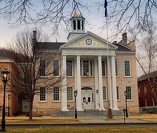
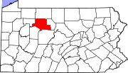
Tioga County is a county in the Commonwealth of Pennsylvania. As of the 2020 census, the population was 41,045. Its county seat is Wellsboro. The county was created on March 26, 1804, from part of Lycoming County and later organized in 1812. It is named for the Tioga River. The county is part of the North Central Pennsylvania region of the state.

<span class="mw-page-title-main">Susquehanna County, Pennsylvania</span> County in Pennsylvania, United States

Susquehanna County is a county in the Commonwealth of Pennsylvania. As of the 2020 census, the population was 38,434 Its county seat is Montrose. The county was created on February 21, 1810, from part of Luzerne County and later organized in 1812. It is named for the Susquehanna River. The county is part of the Northeast Pennsylvania region of the state.

<span class="mw-page-title-main">Potter County, Pennsylvania</span> County in Pennsylvania, United States

Potter County is a county in the Commonwealth of Pennsylvania. As of the 2020 census, its population was 16,396, making it the fifth-least populous county in Pennsylvania. Its county seat is Coudersport. The county was created in 1804 and later organized in 1836. It is named after James Potter, who was a general from Pennsylvania in the Continental Army during the American Revolution. Due to its remoteness and natural environment, it has been nicknamed “God's Country”.

<span class="mw-page-title-main">McKean County, Pennsylvania</span> County in Pennsylvania, United States

McKean County is a rural county in the Commonwealth of Pennsylvania. As of the 2020 census, the population was 40,432. Its county seat is Smethport. The county was created in 1804 and organized in 1826. It was named in honor of former Pennsylvania Governor and Declaration of Independence signer Thomas McKean. The county is part of the North Central Pennsylvania region of the state.

<span class="mw-page-title-main">Jefferson County, Pennsylvania</span> County in Pennsylvania, United States

Jefferson County is a county in the Commonwealth of Pennsylvania. As of the 2020 census, the population was 44,492. Its county seat is Brookville. The county was established on March 26, 1804, from part of Lycoming County and later organized in 1830. It is named for President Thomas Jefferson. It is home to Punxsutawney Phil, the most famous groundhog that predicts when spring will come every February 2 on Groundhog Day. The county is part of the North Central Pennsylvania region of the state.

<span class="mw-page-title-main">Indiana County, Pennsylvania</span> County in Pennsylvania, United States

Indiana County is a county in the Commonwealth of Pennsylvania. It is located in the west central part of Pennsylvania. As of the 2020 census, the population was 83,246. Its county seat is Indiana. Indiana County comprises the Indiana, PA Micropolitan Statistical Area, which is also included in the Pittsburgh-New Castle-Weirton, PA-WV-OH Combined Statistical Area. The county is part of the Southwest Pennsylvania region of the state.

<span class="mw-page-title-main">Forest County, Pennsylvania</span> County in Pennsylvania, United States

Forest County is a county in the Commonwealth of Pennsylvania. As of the 2020 census, the population was 6,973, making it the third-least populous county in Pennsylvania. Its county seat is Tionesta. The county was created in 1848 and later organized in 1857. The county is part of the North Central Pennsylvania region of the state.

<span class="mw-page-title-main">Clearfield County, Pennsylvania</span> County in Pennsylvania, United States

Clearfield County is a county in the Commonwealth of Pennsylvania. As of the 2020 census, the population was 80,562. The county seat is Clearfield, and the largest city is DuBois. The county was created in 1804 and later organized in 1822.

<span class="mw-page-title-main">Clarion County, Pennsylvania</span> County in Pennsylvania, United States

Clarion County is a county in the Commonwealth of Pennsylvania. As of the 2020 census, the population was 37,241. Its county seat is Clarion. The county was formed on March 11, 1839, from parts of Venango and Armstrong counties. Clarion County is entirely defined as part of the Pittsburgh media market. The county is part of the North Central Pennsylvania region of the state.

<span class="mw-page-title-main">Centre County, Pennsylvania</span> County in Pennsylvania, United States

Centre County is a county in the Commonwealth of Pennsylvania, United States. As of the 2020 census, the population was 158,172. Its county seat is Bellefonte. Centre County comprises the State College, PA Metropolitan Statistical Area. The county is part of the Central Pennsylvania region of the state.

<span class="mw-page-title-main">Cameron County, Pennsylvania</span> County in Pennsylvania, United States

Cameron County is a county in the Commonwealth of Pennsylvania. As of the 2020 census, the population was 4,547 and is Pennsylvania's least populous county. Its county seat is Emporium. The county was created on March 29, 1860, from parts of Clinton, Elk, McKean, and Potter Counties. It is named for Senator Simon Cameron. The county is part of the North Central Pennsylvania region of the state.

<span class="mw-page-title-main">Cambria County, Pennsylvania</span> County in Pennsylvania, United States

Cambria County is a county in the Commonwealth of Pennsylvania. As of the 2020 census, the population was 133,472. Its county seat is Ebensburg. The county was created on March 26, 1804, from parts of Bedford, Huntingdon, and Somerset counties and later organized in 1807. It was named for the nation of Wales, which in Latin is known as "Cambria". The county is part of the Southwest Pennsylvania region of the state.

<span class="mw-page-title-main">Bradford County, Pennsylvania</span> County in Pennsylvania, United States

Bradford County is a county in the Commonwealth of Pennsylvania. As of the 2020 census, its population was 59,967. Its county seat is Towanda. The county was created on February 21, 1810, from parts of Lycoming and Luzerne Counties. Originally called Ontario County, it was reorganized and separated from Lycoming County on October 13, 1812, and renamed Bradford County for William Bradford, who had been a chief justice of the Pennsylvania Supreme Court and United States Attorney General. The county is part of the Northeast Pennsylvania region of the state.

<span class="mw-page-title-main">Johnsonburg, Pennsylvania</span> Borough in Pennsylvania, United States

Johnsonburg is a borough in Elk County, Pennsylvania, 124 miles (200 km) northeast of Pittsburgh and 115 miles (185 km) south of Buffalo, New York, in a productive farming and lumbering region. Paper mills were once common in the borough, with the Domtar mill still operating. In 1910, 4,334 people lived here. The population was 2,404 at the 2020 census.

<span class="mw-page-title-main">Ridgway, Pennsylvania</span> Borough in Pennsylvania, United States

Ridgway is a borough in and the county seat of Elk County, Pennsylvania. As of the 2020 census it had a population of 4,039

<span class="mw-page-title-main">St. Marys, Pennsylvania</span> City in Pennsylvania, United States

St. Marys is a city in Elk County, Pennsylvania, United States. The population is 12,738 as of the 2020 census. Originally a small town inhabited by mostly Bavarian Roman Catholics, it was founded December 8, 1842. It is home to Straub Brewery and the first Benedictine convent in the United States. In 1992, the borough of St. Marys absorbed the surrounding township of Benzinger and incorporated as a city. Despite its place as the second-largest city by area in Pennsylvania behind Philadelphia, it is one of the state's least densely populated cities.

<span class="mw-page-title-main">Johnsonburg Area School District</span> School district in Pennsylvania

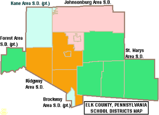
The Johnsonburg Area School District is a small, rural, public school district that serves parts of Elk County, Pennsylvania. It encompasses the communities of Johnsonburg, Ridgway Township, and Jones Township. Johnsonburg Area School District encompasses 227 square miles (590 km2).

Kersey is an unincorporated community and census-designated place in Fox Township, Elk County, Pennsylvania, United States. As of the 2020 census the population was 797.

References

  1. Includes Clearfield, Jefferson, Tioga, McKean, Warren, Clarion, Elk, Potter, Forest and Cameron Counties
  1. "Population and Housing Unit Estimates" . Retrieved March 14, 2022.
  2. "Census - Geography Profile: Elk County, Pennsylvania". United States Census Bureau . Retrieved June 26, 2022.
  3. "Find a County". National Association of Counties. Archived from the original on May 31, 2011. Retrieved June 7, 2011.
  4. "2010 Census Gazetteer Files". US Census Bureau. August 22, 2012. Retrieved March 5, 2015.
  5. "PRISM Climate Group at Oregon State University".
  6. "U.S. Census website". US Census Bureau. Retrieved August 31, 2022.
  7. "Census 2020".
  8. "P2 HISPANIC OR LATINO, AND NOT HISPANIC OR LATINO BY RACE – 2020: DEC Redistricting Data (PL 94-171) – Elk County, Pennsylvania".
  9. Leip, David. "Atlas of US Presidential Elections". uselectionatlas.org. Retrieved November 25, 2018.
  10. Pennsylvania Department of State (April 29, 2024). "Voter registration statistics by county". dos.pa.gov. Retrieved May 5, 2024.
  11. 1 2 Center, Legislativate Data Processing. "Find Your Legislator". The official website for the Pennsylvania General Assembly. Retrieved May 11, 2017.
  12. Portland Mills PA (Google Maps - accessed 11 November 2019)
  13. "2010 U.S. Census website". United States Census Bureau . Retrieved February 10, 2013.

41°25′N78°39′W / 41.42°N 78.65°W / 41.42; -78.65