Ridgway, Pennsylvania

Last updated

Ridgway, Pennsylvania
Ridgway PA from Country Club Apr 10.JPG
Ridgway from Elk County Country Club, April 2010
Seal of Ridgway, Pennsylvania.png
Elk County Pennsylvania incorporated and unincorporated areas Ridgway highlighted.svg
Location in Elk County and the U.S. state of Pennsylvania.
Coordinates: 41°25′29″N78°43′47″W / 41.42472°N 78.72972°W / 41.42472; -78.72972
Country United States
State Pennsylvania
County Elk
Settled1824
Incorporated1880
Government
  TypeBorough Council
  MayorRaymond Imhof
Area
[1]
  Total2.67 sq mi (6.91 km2)
  Land2.61 sq mi (6.77 km2)
  Water0.06 sq mi (0.14 km2)
Elevation
1,381 ft (421 m)
Population
 (2020) [2]
  Total4,039
  Density1,546.32/sq mi (596.98/km2)
Time zone UTC-5 (Eastern (EST))
  Summer (DST) UTC-4 (EDT)
ZIP code
15853
Area code 814
FIPS code 42-64784
Website www.ridgwayborough.com

Ridgway is a borough in and the county seat of Elk County, Pennsylvania. [3] As of the 2020 census it had a population of 4,039 [4]

Contents

History

Ridgway is named for the Philadelphia shipping merchant, Jacob Ridgway. Jacob-Ridgway.png
Ridgway is named for the Philadelphia shipping merchant, Jacob Ridgway.

Ridgway was founded by Philadelphian shipping merchant Jacob Ridgway and James Gillis. [5] Jacob Ridgway earned substantial wealth both in Philadelphia and abroad in London. He constantly sent sums of money back to be invested in property. In the early 19th century as part of a larger land purchase, Ridgway acquired 40,000 acres (160 km2) that became Elk County. One of Jacob Ridgway's nephews by marriage, James Gillis, convinced Ridgway that the area could become a very lucrative spot for a lumber camp due to the proximity of Elk Creek and the Clarion River, a tributary of the Allegheny River. Coal and natural gas abound in the district. In the past, the industrial interests were manufacturing leather, iron, clay, and lumber products, silk goods, railroad snow plows, dynamos, and machine tools. In 1900, the people living here numbered 3,515; in 1910, 5,408; in 1940, 6,253, and in 2010, 4,078.

Many historic structures are located within the boundaries of the Ridgway Historic District, added to the National Register of Historic Places in 2003. The O.B. Grant House and Ridgway Armory are also listed on the National Register of Historic Places. [6]

The lumber industry continued to flourish in Ridgway, to the degree that around the start of the 20th century, the town claimed it had more millionaires per capita than any other town in the U.S. [7]

Geography

Ridgway is located in central Elk County at 41°25′29″N78°43′47″W / 41.42472°N 78.72972°W / 41.42472; -78.72972 (41.424739, -78.729733). [8] It is surrounded by Ridgway Township.

The borough is in the valley of the Clarion River, where it is joined from the east by Elk Creek. U.S. Route 219 passes through the borough center, leading north 44 miles (71 km) to Bradford and south 28 miles (45 km) to DuBois.

According to the United States Census Bureau, the borough has a total area of 2.67 square miles (6.91 km2), of which 2.61 square miles (6.77 km2) is land and 0.054 square miles (0.14 km2), or 2.07%, is water. [4]

Climate

Climate data for Ridgway, Pennsylvania (1991–2020 normals, extremes 1913–present)
MonthJanFebMarAprMayJunJulAugSepOctNovDecYear
Record high °F (°C)72
(22)
74
(23)
82
(28)
92
(33)
97
(36)
106
(41)
110
(43)
101
(38)
103
(39)
91
(33)
80
(27)
73
(23)
110
(43)
Mean daily maximum °F (°C)33.7
(0.9)
36.5
(2.5)
45.4
(7.4)
58.9
(14.9)
70.1
(21.2)
77.4
(25.2)
81.2
(27.3)
80.1
(26.7)
73.6
(23.1)
61.6
(16.4)
49.0
(9.4)
38.3
(3.5)
58.8
(14.9)
Daily mean °F (°C)24.9
(−3.9)
26.5
(−3.1)
34.3
(1.3)
45.9
(7.7)
56.7
(13.7)
64.9
(18.3)
68.8
(20.4)
67.7
(19.8)
61.2
(16.2)
49.9
(9.9)
39.3
(4.1)
30.5
(−0.8)
47.5
(8.6)
Mean daily minimum °F (°C)16.2
(−8.8)
16.5
(−8.6)
23.2
(−4.9)
32.9
(0.5)
43.3
(6.3)
52.4
(11.3)
56.5
(13.6)
55.3
(12.9)
48.8
(9.3)
38.2
(3.4)
29.6
(−1.3)
22.7
(−5.2)
36.3
(2.4)
Record low °F (°C)−31
(−35)
−35
(−37)
−23
(−31)
−1
(−18)
17
(−8)
27
(−3)
34
(1)
26
(−3)
22
(−6)
11
(−12)
−10
(−23)
−24
(−31)
−35
(−37)
Average precipitation inches (mm)3.44
(87)
2.67
(68)
3.41
(87)
3.89
(99)
4.32
(110)
4.62
(117)
4.57
(116)
3.90
(99)
4.03
(102)
3.76
(96)
3.49
(89)
3.45
(88)
45.55
(1,157)
Average snowfall inches (cm)15.3
(39)
12.5
(32)
7.5
(19)
1.5
(3.8)
0.0
(0.0)
0.0
(0.0)
0.0
(0.0)
0.0
(0.0)
0.0
(0.0)
0.4
(1.0)
3.2
(8.1)
12.3
(31)
52.7
(134)
Average precipitation days (≥ 0.01 in)17.414.013.714.014.413.712.211.111.314.013.116.7165.6
Average snowy days (≥ 0.1 in)9.87.64.51.20.00.00.00.00.00.32.16.431.9
Source: NOAA [9] [10]

Demographics

Historical population
CensusPop.Note
1880 1,100
1890 1,90373.0%
1900 3,51584.7%
1910 5,40853.9%
1920 6,03711.6%
1930 6,3134.6%
1940 6,253−1.0%
1950 6,244−0.1%
1960 6,3872.3%
1970 6,022−5.7%
1980 5,604−6.9%
1990 4,793−14.5%
2000 4,591−4.2%
2010 4,078−11.2%
2020 4,039−1.0%
Sources: [11] [12] [13]

2010

At the 2010 census there were 4,078 people, 1,783 households, and 1,073 families living in the borough. The population density was 1,568.5 inhabitants per square mile (605.6/km2). There were 2,068 housing units at an average density of 795.4 units per square mile (307.1 units/km2). The racial makeup of the borough was 97.7% White, 0.6% African American, 0.1% Native American, 0.6% Asian, 0.1% from other races, and 0.9% from two or more races. Hispanic or Latino of any race were 0.6%. [14]

There were 1,783 households, 26.1% had children under the age of 18 living with them, 45.3% were married couples living together, 9.8% had a female householder with no husband present, and 39.8% were non-families. 35.3% of households were made up of individuals, and 15.1% were one person aged 65 or older. The average household size was 2.25 and the average family size was 2.91.

The age distribution was 22.8% under the age of 18, 59.9% from 18 to 64, and 17.3% 65 or older. The median age was 43 years.

The median household income was $37,917 and the median family income was $47,969. Males had a median income of $34,629 versus $28,750 for females. The per capita income for the borough was $22,415. About 17.5% of families and 18.1% of the population were below the poverty line, including 39.3% of those under age 18 and 7.2% of those age 65 or over.

2000

At the 2000 census there were 4,591 people, 1,927 households, and 1,233 families living in the borough. The population density was 1,722.7 inhabitants per square mile (665.1/km2). There were 2,089 housing units at an average density of 783.8 units per square mile (302.6 units/km2). The racial makeup of the borough was 98.54% White, 0.17% African American, 0.04% Native American, 0.70% Asian, 0.17% from other races, and 0.37% from two or more races. Hispanic or Latino of any race were 0.52%. [12]

There were 1,927 households, 28.4% had children under the age of 18 living with them, 50.1% were married couples living together, 9.7% had a female householder with no husband present, and 36.0% were non-families. 31.7% of households were made up of individuals, and 16.8% were one person aged 65 or older. The average household size was 2.33 and the average family size was 2.94.

The age distribution was 22.9% under the age of 18, 8.2% from 18 to 24, 27.8% from 25 to 44, 22.8% from 45 to 64, and 18.3% 65 or older. The median age was 40 years. For every 100 females there were 91.2 males. For every 100 females age 18 and over, there were 89.3 males.

The median household income was $33,141 and the median family income was $45,224. Males had a median income of $31,855 versus $21,296 for females. The per capita income for the borough was $17,157. About 4.9% of families and 6.1% of the population were below the poverty line, including 8.9% of those under age 18 and 2.3% of those age 65 or over.

Art and culture

Ridgway is home to the Ridgway Chainsaw Carving Rendezvous, the largest chainsaw carving gathering of its kind. In the summer months, the Ridgway Volunteer Fire Department host their week-long celebration on their lot off North Broad Street. The Ridgway Heritage Council hosts the Tasting in the Wilds Festival, which is full of art, music, local wine tastings, and handcrafted brews.

The Elk County Council on the Arts (ECCOTA) has been serving the area with art experiences, education, and resources since 1984. ECCOTA operates a sales gallery in downtown Ridgway with artwork of all mediums from local artists.

Recreation

The area serves as a gateway to the Allegheny National Forest, which provides outdoor recreation activities including ATV trails, horseback riding, camping and fishing. Ridgway has several bed and breakfasts, the Summit Fireside Lodge and Grill, and the oldest hotel in Elk County, the Royal Inn. The Wild and Scenic Clarion River hosts trophy trout fishing, an afternoon float and camping. The Little Toby-Clarion River Rail Trail trek runs 18 miles (29 km) to Brockway.

Education

Ridgway houses two school systems in the borough and township. The Ridgway Area School District and St. Leo's Catholic School make up Ridgway's school systems.

Ridgway Area School District

Ridgway Area School District (RASD), has an elementary and a middle/high school building.

The Francis S. Grandinetti Elementary School is on Boot Jack Hill in Ridgway Township. IU9 preschool, kindergarten, 1st grade, 2nd grade, 3rd grade, 4th grade, and 5th grade are the grade levels available for students.

The Ridgway Area Middle/High School is at 1403 Hill Street in Ridgway. The middle school and high school students are on separate floors. The middle school, grades six through eight, are on the first floor. Students in high school, grades nine to twelve, are on the second floor.

The athletic team is known as the Elkers, a reference to Ridgway as the Elk County seat.

St. Leo's Catholic School

St. Leo's Catholic School has two buildings, a building for kindergarten students, and a main building, for children in grades 1–8. The kindergarten building is located just to the right of the main building. The preschool building is located to the left of the main building. The main building at St. Leo's educates children from grades 1–8. After completing 8th grade, students have the choice to transfer to public school (see above) or to transfer to Elk County Catholic High School, in St. Marys.

Notable people

Related Research Articles

<span class="mw-page-title-main">Elk County, Pennsylvania</span> County in Pennsylvania, United States

Elk County is a county in the Commonwealth of Pennsylvania. As of the 2020 United States census, the population was 30,990. Its county seat is Ridgway. The county was created on April 18, 1843, from parts of Jefferson, Clearfield, and McKean Counties. Elk County is named for the now-extinct eastern elk that historically inhabited the region. The county is part of the North Central Pennsylvania region of the state.

<span class="mw-page-title-main">Goldfield, Iowa</span> City in Iowa, United States

Goldfield is a city in Wright County, Iowa, United States. The population was 634 at the time of the 2020 census.

<span class="mw-page-title-main">South Bethlehem, Pennsylvania</span> Borough in Pennsylvania, United States

South Bethlehem is a borough in Armstrong County, Pennsylvania, United States. The population was 489 at the 2020 census.

<span class="mw-page-title-main">Brady Township, Clarion County, Pennsylvania</span> Township in Pennsylvania, United States

Brady Township is a township in Clarion County, Pennsylvania, United States. The population was 75 at the 2020 census, an increase from the figure of 55 tabulated in 2010.

<span class="mw-page-title-main">Callensburg, Pennsylvania</span> Borough in Pennsylvania, United States

Callensburg is a borough in Clarion County, Pennsylvania, United States. The population was 207 at the 2010 census.

<span class="mw-page-title-main">East Brady, Pennsylvania</span> Borough in Pennsylvania, United States

East Brady is a borough in Clarion County, Pennsylvania, United States. The population was 822 at the 2020 census. Clarion County's designated tourism agency is the Clarion County Economic Development Corporation

<span class="mw-page-title-main">Elk Township, Clarion County, Pennsylvania</span> Township in Pennsylvania, United States

Elk Township is a township in Clarion County, Pennsylvania, United States. The population was 1,432 at the 2020 census, a decrease from the figure of 1,490 tabulated in 2010.

<span class="mw-page-title-main">Paint Township, Clarion County, Pennsylvania</span> Township in Pennsylvania, United States

Paint Township is a township in Clarion County, Pennsylvania, United States. The population was 1,645 at the 2020 census, a decrease from the figure of 1,699 tabulated in 2010.

<span class="mw-page-title-main">Strattanville, Pennsylvania</span> Borough in Pennsylvania, United States

Strattanville is a borough in Clarion County, Pennsylvania, United States. The population was 537 at the 2020 census.

<span class="mw-page-title-main">South Renovo, Pennsylvania</span> Borough in Pennsylvania, United States

South Renovo is a borough in Clinton County, Pennsylvania, United States, located on the West Branch Susquehanna River, directly across from Renovo. The population was 439 at the 2010 census, down from 557 in 2000.

<span class="mw-page-title-main">Horton Township, Elk County, Pennsylvania</span> Township in Pennsylvania, United States

Horton Township is a township in Elk County, Pennsylvania, United States. The population was 1,365 at the 2020 census, down from 1,452 in 2010.

<span class="mw-page-title-main">Johnsonburg, Pennsylvania</span> Borough in Pennsylvania, United States

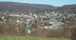
Johnsonburg is a borough in Elk County, Pennsylvania, 124 miles (200 km) northeast of Pittsburgh and 115 miles (185 km) south of Buffalo, New York, in a productive farming and lumbering region. Paper mills were once common in the borough, with the Domtar mill still operating. In 1910, 4,334 people lived here. The population was 2,404 at the 2020 census.

<span class="mw-page-title-main">Jones Township, Elk County, Pennsylvania</span> Township in Pennsylvania, United States

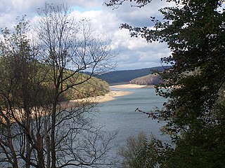
Jones Township is a township in Elk County, Pennsylvania, United States. The population was 1,569 at the 2020 census, down from 1,624 in 2010. Bendigo State Park and part of Elk State Park are in Jones Township, on the East Branch of the Clarion River.

<span class="mw-page-title-main">Millstone Township, Pennsylvania</span> Township in Pennsylvania, United States

Millstone Township is a township in Elk County, Pennsylvania, United States. The population was 95 at the 2020 census, up from 82 in 2010.

<span class="mw-page-title-main">Ridgway Township, Pennsylvania</span> Township in Pennsylvania, United States

Ridgway Township is a township in Elk County, Pennsylvania, United States. The population was 2,424 at the 2020 census, down from 2,523 in 2010, down from 2,802 at the 2000 census.

<span class="mw-page-title-main">Spring Creek Township, Elk County, Pennsylvania</span> Township in Pennsylvania, United States

Spring Creek Township is a township in Elk County, Pennsylvania, United States. The population was 198 at the 2020 census, down from 233 in 2010.

<span class="mw-page-title-main">St. Marys, Pennsylvania</span> City in Pennsylvania, United States

St. Marys is a city in Elk County, Pennsylvania, United States. The population is 12,738 as of the 2020 census. Originally a small town inhabited by mostly Bavarian Roman Catholics, it was founded December 8, 1842. It is home to Straub Brewery and the first Benedictine convent in the United States. In 1992, the borough of St. Marys absorbed the surrounding township of Benzinger and incorporated as a city. Despite its place as the second-largest city by area in Pennsylvania behind Philadelphia, it is one of the state's least densely populated cities.

<span class="mw-page-title-main">Corsica, Pennsylvania</span> Borough in Pennsylvania, United States

Corsica is a borough in Jefferson County, Pennsylvania, United States. The population was 357 at the 2010 census. It was named for the island of Corsica, birthplace of Napoleon Bonaparte. The mayor of the borough is Dave Leadbetter.

<span class="mw-page-title-main">Snyder Township, Jefferson County, Pennsylvania</span> Township in Pennsylvania, United States

Snyder Township is a township in Jefferson County, Pennsylvania, United States. The population was 2,366 at the 2020 census. It was named for Governor of Pennsylvania Simon Snyder.

<span class="mw-page-title-main">Union Dale, Pennsylvania</span> Borough in Pennsylvania, United States

Union Dale is a borough in Susquehanna County, Pennsylvania, United States. The borough was incorporated in 1885. Union Dale's population was 267 at the 2010 census.

References

  1. "ArcGIS REST Services Directory". United States Census Bureau. Retrieved August 8, 2023.
  2. "Census Population API". United States Census Bureau. Retrieved October 12, 2022.
  3. "Find a County". National Association of Counties. Archived from the original on May 31, 2011. Retrieved June 7, 2011.
  4. 1 2 "Geographic Identifiers: 2010 Demographic Profile Data (G001): Ridgway borough, Pennsylvania". American Factfinder. U.S. Census Bureau. Archived from the original on February 13, 2020. Retrieved March 10, 2016.
  5. McKnight, W. J. (1905). A Pioneer Outline History of Northwestern Pennsylvania. Philadelphia, Pennsylvania: J. B. Lippincott Company. pp. 501–502. Retrieved August 13, 2023.
  6. "National Register Information System". National Register of Historic Places . National Park Service. March 13, 2009.
  7. "Show Us the Money". Forbes .
  8. "US Gazetteer files: 2010, 2000, and 1990". United States Census Bureau. February 12, 2011. Retrieved April 23, 2011.
  9. "NowData – NOAA Online Weather Data". National Oceanic and Atmospheric Administration. Retrieved August 7, 2021.
  10. "Station: Ridgway, PA". U.S. Climate Normals 2020: U.S. Monthly Climate Normals (1991–2020). National Oceanic and Atmospheric Administration. Retrieved August 7, 2021.
  11. "Census of Population and Housing". U.S. Census Bureau. Retrieved December 11, 2013.
  12. 1 2 "U.S. Census website". United States Census Bureau . Retrieved January 31, 2008.
  13. "Incorporated Places and Minor Civil Divisions Datasets: Subcounty Resident Population Estimates: April 1, 2010 to July 1, 2012". Population Estimates. U.S. Census Bureau. Archived from the original on June 11, 2013. Retrieved December 11, 2013.
  14. "U.S. Census website". United States Census Bureau . Retrieved May 14, 2011.