Hester Street is a street in the Lower East Side of the New York City borough of Manhattan. It stretches from Essex Street to Centre Street, with a discontinuity between Chrystie Street and Forsyth Street for Sara Delano Roosevelt Park. There is also a discontinuity at Allen Street, which was created in 2009 with the rebuilding of the Allen Street Mall. At Centre Street, Hester Street shifts about 100 feet (30 m) to the north and is called Howard Street to its far western terminus at Mercer Street.
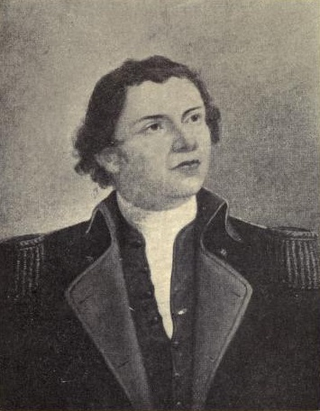
Hugh Mercer was a brigadier general in the Continental Army during the American Revolutionary War. He fought in the New York and New Jersey campaign and was mortally wounded at the Battle of Princeton.

Lincoln Square is the name of both a square and the surrounding neighborhood on the Upper West Side of Manhattan in New York City. Lincoln Square is centered on the intersection of Broadway and Columbus Avenue, between West 65th and 66th streets. The neighborhood is bounded by Columbus and Amsterdam avenues to the east and west, and 66th and 63rd streets to the north and south, respectively. However, the term can be extended to refer to the neighborhood between 59th and 72nd streets. It is bounded by Hell's Kitchen, Riverside South, Central Park, and the Upper West Side proper. The Walt Disney Company’s New York City campus is located here, including ABC, ESPN, Hulu and studios for WABC-TV.

The Robb House, located at 23 Park Avenue on the corner of East 35th Street in the Murray Hill neighborhood of Manhattan, New York City is a townhouse built in 1888-92 and designed in the Italian Renaissance revival style by McKim, Mead & White, with Stanford White as the partner-in-charge.

Henry Street is a street in the Lower East Side of the New York City borough of Manhattan that runs one-way eastbound, except for two small two-way segments west of Pike Street and east of Montgomery Street. It spans from Oliver Street in the west, passing underneath the Manhattan Bridge and on to Grand Street in the east ("north"). The street is named for Henry Rutgers, a hero of the American Revolutionary War, and prominent philanthropist. Rutgers Street, which intersects with Henry Street, is also named for him.

Maiden Lane is an east–west street in the Financial District of Lower Manhattan, New York City. Its eastern end is at South Street, near the South Street Seaport, and its western end is at Broadway near the World Trade Center site, where it becomes Cortlandt Street.

520 West End Avenue, also known as the John B. and Isabella Leech Residence, is a landmarked mansion on the northeast corner of West End Avenue and 85th Street, on the Upper West Side of Manhattan.

The Sawkill or Saw-kill was the largest hydrological network on Manhattan island in New York City before the Dutch colony of New Netherland was founded in 1624. This 44,980-foot-long (13,710 m) stream began "within four blocks of the Hudson River":
A rill flowing east from the rocky ridge overlooking Bloomingdale Village, which rose near Ninth Avenue and 85th Street, flowed in a southerly direction through Manhattan Square, where it spread into a little pond, and then turned east, crossing Central Park to Fifth Avenue, receiving three tributaries within its limits, two from the north and one from the south. At 75th Street near Third Avenue it was joined by another stream. Near this junction the old Boston Post Road crossed it, and then from this point, the stream ran due east to its outlet near the foot of 75th Street

133rd Street is a street in Manhattan and the Bronx, New York City. In Harlem, Manhattan, it begins at Riverside Drive on its western side and crosses Broadway, Amsterdam Avenue, and ends at Convent Avenue, before resuming on the eastern side, crossing Seventh Avenue, and ending at Lenox Avenue. In Port Morris in the Bronx, it runs from Bruckner Boulevard/St. Ann's Place to Locust Avenue. The block between Seventh Avenue and Lenox Avenues was once a thriving night spot, known as "Swing Street", with numerous cabarets, jazz clubs, and speakeasies. The street is described in modern times as "a quiet stretch of brownstones and tenement-style apartment houses, the kind of block that typifies this section of central Harlem".

The Second Congregational Church in New York, organized in 1825, was a Unitarian congregation which had three permanent homes in Manhattan, New York City, the second of which became a theater after they left it. In 1919 the congregation joined the Community Church Movement and changed its name to Community Church of New York. The same year its church, on 34th Street, was damaged by fire. Since 1948 the congregation has been located at 40 East 35th Street. It is currently part of the Unitarian Universalist Association.

The Edward S. Harkness House, located at 1 East 75th Street and Fifth Avenue, is a mansion in the Upper East Side of Manhattan in New York City. It was constructed between 1907 and 1908 for Edward and Mary Harkness by James Gamble Rogers, a principal of the firm Hale & Rogers.

University Place is a short north-south thoroughfare in the Greenwich Village neighborhood of Manhattan, New York City, United States, which runs from Washington Square Park in the south as a continuation of Washington Square East, taking the position of Madison Avenue uptown, and terminates at East 14th Street just southwest of Union Square. Although the roadway continues north of 14th Street as Union Square West, traffic on the two streets run in opposite directions, both feeding into 14th Street. Until the late 1990s, University Place was a two-way street. The street contains numerous cafes, shops, and restaurants, many of which cater to students at NYU and The New School.

Scheffel Hall at 190 Third Avenue in the Gramercy Park neighborhood of Manhattan, New York City, was built in 1894–1895, and designed by Henry Adams Weber and Hubert Drosser, at a time when the area south of it was known as Kleindeutschland due to the large number of German immigrants who lived nearby. The building, which served as a beer hall and restaurant, was modeled after an early 17th-century building in Heidelberg Castle, the "Friedrichsbau", and was named after Joseph Viktor von Scheffel, a German poet and novelist. It later became known as Allaire's, a name still inscribed on the building. The building's style has been described as "German-American eclectic Renaissance Revival".

The St. Aloysius Catholic Church is a Catholic parish in the Archdiocese of New York, located at 209-217 West 132nd Street between Adam Clayton Powell Jr. Boulevard and Frederick Douglass Boulevard in the Harlem neighborhood of Manhattan, New York City.

The Church of St. Catherine of Genoa is a Roman Catholic parish church in the Roman Catholic Archdiocese of New York, located at 504 West 153rd Street, between Broadway and Amsterdam Avenue in the Hamilton Heights neighborhood of Manhattan, New York City.

The Church of the Epiphany is a parish church of the Roman Catholic Archdiocese of New York, located at 373 Second Avenue at the corner of East 22nd Street, in the Gramercy Park neighborhood of Manhattan in New York City. It operates a co-educational PreK–8 Catholic school and Religious Education program.

The New Era Building is an 1893 Art Nouveau commercial loft building at 495 Broadway, between Spring Street and Broome Street, in the SoHo section of Manhattan in New York City.

Fanelli Cafe is a historic New York City restaurant and bar considered the city's second-oldest food-and-drink establishment in the same locale, having operated under various owners at 94 Prince Street since 1847. It served as a gathering place for artists during the transition of Manhattan's SoHo neighborhood from a manufacturing area to an arts community.
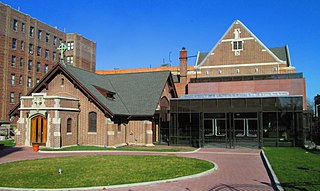
Fort Washington Collegiate Church is a Collegiate Reformed Protestant Dutch Church located at Magaw Place and 181st Street in the Washington Heights neighborhood of Manhattan, New York City.

Eldridge Street is a street in the Lower East Side and Chinatown neighborhoods of Manhattan in New York City, running from Houston Street in the north to East Broadway in the south. Originally called Third Street according to the numbering system for the Delancey Farm Grid, it was named in 1817 for Lt. Joseph C. Eldridge, whose unit was ambushed by Indian allies of the British in Upper Canada during the War of 1812.
