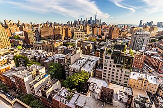
Greenwich Village, or simply The Village, is a neighborhood on the west side of Lower Manhattan in New York City, bounded by 14th Street to the north, Broadway to the east, Houston Street to the south, and the Hudson River to the west. Greenwich Village also contains several subsections, including the West Village west of Seventh Avenue and the Meatpacking District in the northwest corner of Greenwich Village.

Houston Street is a major east–west thoroughfare in Lower Manhattan in New York City. It runs the full width of the island of Manhattan, from FDR Drive along the East River in the east to the West Side Highway along the Hudson River in the west. The street is divided into west and east sections by Broadway.
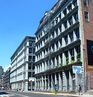
SoHo, sometimes written Soho, is a neighborhood in Lower Manhattan, New York City. Since the 1970s, the neighborhood has been the location of many artists' lofts and art galleries, and has also been known for its variety of shops ranging from trendy upscale boutiques to national and international chain store outlets. The area's history is an archetypal example of inner-city regeneration and gentrification, encompassing socioeconomic, cultural, political, and architectural developments.

NoHo, short for North of Houston Street, is a primarily residential neighborhood in Lower Manhattan in the New York City borough of Manhattan. It is bounded by Mercer Street to the west and the Bowery to the east, and from East 9th Street in the north to East Houston Street in the south.

The East Village is a neighborhood on the East Side of Lower Manhattan in New York City. It is roughly defined as the area east of the Bowery and Third Avenue, between 14th Street on the north and Houston Street on the south. The East Village contains three subsections: Alphabet City, in reference to the single-letter-named avenues that are located to the east of First Avenue; Little Ukraine, near Second Avenue and 6th and 7th Streets; and the Bowery, located around the street of the same name.

Sixth Avenue – also known as Avenue of the Americas, although this name is seldom used by New Yorkers – is a major thoroughfare in New York City's borough of Manhattan, on which traffic runs northbound, or "uptown". It is commercial for much of its length.
Seventh Avenue – co-named Fashion Avenue in the Garment District and known as Adam Clayton Powell Jr. Boulevard north of Central Park – is a thoroughfare on the West Side of the borough of Manhattan in New York City. It is southbound below Central Park and a two-way street north of the park.

Kew Gardens Hills is a neighborhood in the middle of the New York City borough of Queens. The borders are Flushing Meadows-Corona Park to the west, the Long Island Expressway to the north, Union Turnpike to the south, and Parsons Boulevard to the east.

4th Street is a street in Lower Manhattan, New York City. It starts at Avenue D as East 4th Street and continues to Broadway, where it becomes West 4th Street. It continues west until the Avenue of the Americas, where West 4th Street turns north and confusingly intersects with West 10th, 11th, 12th, and 13th Streets in Greenwich Village. Most of the street has the same 40-foot (12 m) width between curbstones as others in the prevailing street grid, striped as two curbside lanes and one traffic lane, with one-way traffic eastbound. The portion from Seventh to Eighth Avenues is westbound and is approximately 35 feet (11 m) wide, a legacy of the original Greenwich Village street grid. The section of four short blocks from MacDougal Street to University Place which forms the southern border of Washington Square Park is called Washington Square South.

The West Village is a neighborhood in the western section of the larger Greenwich Village neighborhood of Lower Manhattan, New York City.

Community boards of Manhattan are New York City community boards in the borough of Manhattan, which are the appointed advisory groups of the community districts that advise on land use and zoning, participate in the city budget process, and address service delivery in their district.

Washington Square Village (WSV) is an apartment complex in a superblock in the Greenwich Village neighborhood of Manhattan, New York City. WSV was developed by Paul Tishman and Morton S. Wolf. To design the housing complex, the developer selected architects S. J. Kessler and Sons, with Paul Lester Weiner as consultant for site planning and design; landscape architects were Sasaki, Walker & Associates.

West Broadway is a north-south street in the New York City borough of Manhattan, separated into two parts by Tribeca Park. The northern part begins at Tribeca Park, near the intersection of Avenue of the Americas, Walker Street and Beach Street in Tribeca. It runs northbound as a one-way street past Canal Street and becomes two-way at the intersection with Grand Street one block farther north. West Broadway then operates as a main north-south thoroughfare through SoHo until its northern end at Houston Street, on the border between SoHo and Greenwich Village. North of Houston Street, it is designated as LaGuardia Place, which continues until Washington Square South.

MacDougal Street is a one-way street in the Greenwich Village and SoHo neighborhoods of Manhattan, New York City. The street is bounded on the south by Prince Street and on the north by West 8th Street; its numbering begins in the south. Between Waverly Place and West 3rd Street it carries the name Washington Square West and the numbering scheme changes, running north to south, beginning with #29 Washington Square West at Waverly Place and ending at #37 at West 3rd Street. Traffic on the street runs southbound (downtown).

Village Preservation is a non-profit organization which advocates for the preservation of architecture and culture in several neighborhoods of Lower Manhattan, New York. Since it began in 1980, it has engaged in efforts to attain landmark status for a variety of sites like the Stonewall Inn and Webster Hall. The organization and its Executive Director, Andrew Berman, have been described as influential in New York real estate, while some of its activities to prevent development and to support restrictive zoning have attracted criticism.

The South Village is a largely residential area that is part of the larger Greenwich Village in Lower Manhattan, New York City, directly below Washington Square Park. Known for its immigrant heritage and bohemian history, the architecture of the South Village is primarily tenement-style apartment buildings, indicative of the area's history as an enclave for Italian-American immigrants and working-class residents of New York.

Hudson Square is a neighborhood in Lower Manhattan in New York City. It is bounded approximately by Clarkson Street to the north, Canal Street to the south, Varick Street to the east, and the Hudson River to the west. To the north of the neighborhood is Greenwich Village, to the south is TriBeCa, and to the east are the South Village and SoHo. The area, once the site of the colonial property named Richmond Hill, became known in the 20th century as the Printing District, and into the 21st century it remains a center of media-related activity, including in advertising, design, communications, and the arts.

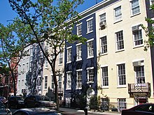
The Charlton–King–Vandam Historic District is a small historic district in Lower Manhattan, New York City. Designated by the New York City Landmarks Preservation Commission (NYCLPC) in 1966, the district contains "the city's largest concentration of row houses in the Federal style, as well as a significant concentration of Greek Revival houses." It is sometimes included as part of the South Village or Hudson Square, though it is historically distinct from both neighborhoods.

Spring Street is a street in Lower Manhattan, New York City, which runs west–east through the neighborhoods of Hudson Square, SoHo, and Nolita. It runs parallel to and between Dominick, Broome, and Kenmare Streets, and Vandam and Prince Streets. Address numbers ascend as Spring Street travels westward from the Bowery to West Street along the Hudson River.
Thompson Street is a street in the Lower Manhattan neighborhoods of Greenwich Village and SoHo in New York City, which runs north–south, from Washington Square Park at Washington Square South to the Avenue of the Americas below Grand Street, where the street turns right to Sixth Avenue; it thus does not connect with Canal Street just a half block south of the turning point. It runs parallel to and between Sullivan Street, and LaGuardia Place which becomes West Broadway. Vehicular traffic goes southbound.