96th Street (Manhattan)

Last updated

96th Street
96ST1AVE.JPG
Crossing First Avenue, looking west
96th Street (Manhattan)
Owner City of New York
Maintained by NYCDOT
Length1.3 mi (2.1 km) [1]
Width100 feet (30.48 m)
Location Manhattan
Postal code10025 (west), 10128 (east)
Coordinates 40°47′39″N73°58′13″W / 40.794051°N 73.970368°W / 40.794051; -73.970368
West endNY-9A.svgHenry Hudson Pkwy Shield free.svg NY 9A  / Henry Hudson Parkway in Riverside Park
East endFDR Drive Shield free.svg FDR Drive in East Harlem
North97th Street
South 95th Street
Construction
Commissioned 1811

96th Street is a major two-way street on the Upper East Side and Upper West Side sections of the New York City borough of Manhattan. It runs in two major sections: between the FDR Drive and Fifth Avenue on the Upper East Side, and between Central Park West and Henry Hudson Parkway on the Upper West Side. The two segments are connected by the 97th Street transverse across Central Park, which links the disconnected segments of 96th and 97th Streets on each side.

Contents

96th Street is one of the 15 hundred-foot-wide (30 m) crosstown streets mapped out in the Commissioner's Plan of 1811 that established the numbered street grid in Manhattan. [2] On Manhattan's West Side, 96th Street is the northern boundary of the New York City steam system, the largest such system in the world, which pumps 30 billion pounds of steam into 100,000 buildings south of the street. [3] (The northern boundary on the East Side is 89th Street. [4] )

East 96th Street

From the FDR Drive to First Avenue, 96th Street is the northern border of Zone A, a flood evacuation zone. [5] When Hurricane Sandy hit New York City in 2012, residents on neighboring blocks found out they, too, were in a flood zone, and the city revised its zone borders outward. Residents of the public housing projects as well as high rise apartments in the zone were left without power, although it was restored to most of the area after a day or two.

96th Street rises after Second Avenue, and climbs from Third Avenue to Lexington Avenue called "Carnegie Hill" before leveling off at Central Park. The street is the traditional dividing line between Yorkville and the Upper East Side to the south and Spanish Harlem or East Harlem to the north. [6] [7]

East 96th Street, particularly near Second and Third Avenues, underwent significant gentrification in the late 1980s. By 2005, a wave of speculation for Harlem real estate pushed a corridor of luxury condos and co-ops up First Avenue from 96th Street as well. The construction of the Second Avenue Subway, which built a station on the street, disrupted lives and businesses along 96th Street, [8] but its opening in January, 2017, was expected to further increase residential and commercial development in East Harlem, as well as increasing housing value in Yorkville. [9]

The Islamic Cultural Center of New York opened at Third Avenue and East 96th Street in 1991. Like all mosques, it is oriented toward Mecca, which required a slight shift in orientation from the neighboring buildings.

The East 96th Street gate to Central Park is called "Woodmans Gate".

East 96th Street is the southern boundary of the area where green taxis may be hailed by passengers. [10]

West 96th Street

96th Street runs under Riverside Drive near its western end 96 under RSD jeh.JPG
96th Street runs under Riverside Drive near its western end

On the West Side, 96th Street runs through a natural valley passing under Riverside Drive and leading down to the former Stryker's Bay. It is regarded as the southern border of the nearby Manhattan Valley area. [11] [12]

Broadway at West 96th Street was home to two ornate theaters the Riverside and the Riviera / Japanese Gardens each designed in the early 20th century, and both gone by 1976. [13]

In the mid 1980s, parts of West 96th Street began to convert from rental units to cooperative housing. At the time, crime remained a problem. As late as the early 1990s, drug dealing was rampant on 96th Street between Broadway and Amsterdam Avenue, and Larry Hogue, a homeless crack addict known as the "Wild Man of 96th Street" terrorized the street for several years until being forced into treatment and extended state custody. [14] In 2009, Hogue escaped from custody and returned briefly to West 96th Street before being found and returned to treatment. [15] The decision by the city to continue locating homeless and frequently drug addicted residents in large former Single Room Occupancy hotels (SROs) within a several block radius of West 96th Street and Broadway continues to be controversial. [16]

The rapid development of Columbus Avenue from 96th to 100th Street around 2009 resulted in a burgeoning concentration of large, national chain stores.

The West 96th Street gate to Central Park is called "Gate of All Saints".

Transportation

The north entrance to 96th Street station at Broadway 96th IRT glazed jeh.JPG
The north entrance to 96th Street station at Broadway

New York City Subway service is available at these stations:

The M96 bus line serves a majority of the street, and the M106 serves the western portion of the street and connects it with East 106th Street.

In the 1989 film When Harry Met Sally... , Harry and Sally are seen buying their Christmas tree from The Plant Shed, a long-established neighborhood store on West 96th Street, near Broadway. A year later, no longer a couple, Sally is seen buying her tree there and trudging home alone with the tree dragging behind her.

In the How I Met Your Mother episode "Last Time in New York", Ted references some misspelled graffiti on the intersection of 96th Street and Amsterdam Avenue. The graffiti read, "YOUR A P***S", which Ted then corrects to "YOU'RE A P***S".

In the 2008 musical "In the Heights"' opening song In the Heights, Usnavi references 96th street when he breaks the fourth wall, while describing how to get to Washington Heights, Manhattan.

In the 1973 movie The Seven-Ups a famous car chase scene with actor Roy Scheider includes a sequence filmed on West 96th Street from Central Park West to West End Avenue. The chase repeats the same intersections on 96th street several times, specifically the dramatic drop from Amsterdam to Broadway and West End Avenue which makes the cars appear to go aloft as they plunge down the hill.

In Saul Bellow's 1969 novel, Mr. Sammler's Planet , Bellow says of the intersection with Broadway "...Ninety-sixth Street tilted at all four corners, the kiosks and movie houses, the ramparts of wire fastened newspaper bundles, and the colors of panic waving."

Related Research Articles

<span class="mw-page-title-main">Yorkville, Manhattan</span> Neighborhood in New York City

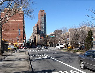
Yorkville is a neighborhood on the Upper East Side of Manhattan, New York City, United States. Its southern boundary is East 79th Street, its northern East 96th Street, its western Third Avenue, and its eastern the East River. Yorkville is one of the most densely populated city subdivisions in the world.

<span class="mw-page-title-main">Upper East Side</span> Neighborhood of Manhattan in New York City

The Upper East Side, sometimes abbreviated UES, is a neighborhood in the borough of Manhattan in New York City, bounded approximately by 96th Street to the north, the East River to the east, 59th Street to the south, and Central Park and Fifth Avenue to the west. The area incorporates several smaller neighborhoods, including Lenox Hill, Carnegie Hill, and Yorkville. Once known as the Silk Stocking District, it has long been the most affluent neighborhood in New York City.

<span class="mw-page-title-main">Second Avenue (Manhattan)</span> North-south avenue in Manhattan, New York

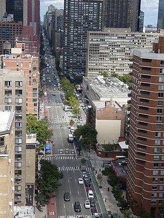
Second Avenue is located on the East Side of the New York City borough of Manhattan extending from Houston Street at its south end to the Harlem River Drive at 128th Street at its north end. A one-way street, vehicular traffic on Second Avenue runs southbound (downtown) only, except for a one-block segment of the avenue in Harlem. South of Houston Street, the roadway continues as Chrystie Street south to Canal Street.

<span class="mw-page-title-main">125th Street (Manhattan)</span> West-east street in Manhattan, New York

125th Street, co-named Martin Luther King Jr. Boulevard, is a two-way street that runs east–west in the New York City borough of Manhattan, from First Avenue on the east to Marginal Street, a service road for the Henry Hudson Parkway along the Hudson River in the west. It is often considered to be the "Main Street" of Harlem.

<span class="mw-page-title-main">Manhattan Valley</span> Neighborhood of Manhattan in New York City

Manhattan Valley is a neighborhood in the northern part of the Upper West Side of Manhattan in New York City. It is bounded by West 110th Street to the north, Central Park West to the east, West 96th Street to the south, and Broadway to the west.

<span class="mw-page-title-main">Ninth Avenue (Manhattan)</span> North-south avenue in Manhattan, New York

Ninth Avenue, known as Columbus Avenue between West 59th and 110th Streets, is a thoroughfare on the West Side of Manhattan in New York City, United States. Traffic runs downtown (southbound) from the Upper West Side to Chelsea. Two short sections of Ninth Avenue also exist in the Inwood neighborhood, carrying two-way traffic.

<span class="mw-page-title-main">86th Street (Manhattan)</span> West-east street in Manhattan, New York

86th Street is a major two-way street in the Upper East Side and Upper West Side of the New York City borough of Manhattan. It runs in two major sections: between East End and Fifth Avenue on the Upper East Side, and between Central Park West and Riverside Drive on the Upper West Side. The western segment feeds into the 86th Street transverse across Central Park, which connects to East 84th and 85th Streets on the eastern side.

Manhattantown, now known as Park West Village or West Park Apartments, was a massive urban renewal project in New York City's Manhattan Valley neighborhood. The project, which stretched between West 96th and West 100th streets, bordering Central Park West, was funded by Title I of the Housing Act of 1949, which financed slum clearance under urban redevelopment initiatives. Allegations of corruption were leveled soon after the project's inception in the spring of 1949, culminating in hearings in the Senate's Banking and Currency Committee in 1954.

<span class="mw-page-title-main">116th Street (Manhattan)</span> West-east street in Manhattan, New York

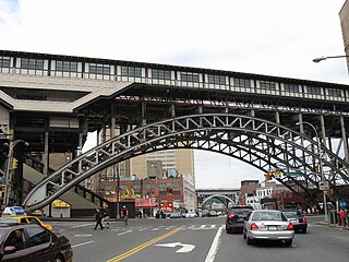
116th Street runs from Riverside Drive, overlooking the Hudson River, to the East River, through the New York City borough of Manhattan. It traverses the neighborhoods of Morningside Heights, Harlem, and Spanish Harlem; the street is interrupted between Morningside Heights and Harlem by Morningside Park.

<span class="mw-page-title-main">79th Street (Manhattan)</span> West-east street in Manhattan, New York

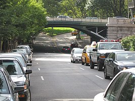
79th Street is a major two-way street on the Upper East Side and Upper West Side of the New York City borough of Manhattan. It runs in two major sections: between East End and Fifth Avenues on the Upper East Side, and between Columbus Avenue and Henry Hudson Parkway on the Upper West Side. The two segments are connected by the 79th Street transverse across Central Park, as well as one block of 81st Street.

<span class="mw-page-title-main">East Side (Manhattan)</span> Area of Manhattan, New York City

East Side of Manhattan refers to the side of Manhattan which abuts the East River and faces Brooklyn and Queens. Fifth Avenue, Central Park from 59th to 110th streets, and Broadway below 8th Street separate it from the West Side.

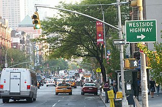
The West Side of Manhattan refers to the side of Manhattan Island that abuts the Hudson River and faces the U.S. state of New Jersey. The West Side is home to several famed New York City locations, including Fifth Avenue, Central Park, and lower Broadway. The major neighborhoods on the West Side are Inwood, Hudson Heights, Washington Heights, West Harlem, Morningside Heights, Manhattan Valley, the Upper West Side, Hell's Kitchen, Chelsea, the West Village, SoHo, and Tribeca. The 8th Avenue and West Side subway lines connect all parts of the West Side.

<span class="mw-page-title-main">Sherman Square</span> Public space in Manhattan, New York

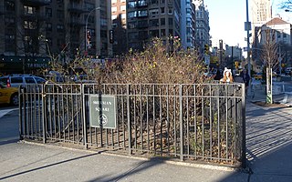
Sherman Square is a pocket park bounded by Broadway, Amsterdam Avenue, and West 70th Street on the Upper West Side of Manhattan, in New York City. It was named in 1891 for William Tecumseh Sherman who lived in the area and died that year.

<span class="mw-page-title-main">Mulry Square</span>

Mulry Square is a triangular parking lot at the southwest corner of Greenwich Avenue and Seventh Avenue South in Greenwich Village, Manhattan, New York City. It was once thought to be the site of a wedge-shaped diner that was the inspiration for Edward Hopper's famous painting Nighthawks. The parking lot's fencing supports Tiles for America, a September 11 memorial consisting of some 6,000 tiles created across the country.

<span class="mw-page-title-main">Madison Square North Historic District</span>

The Madison Square North Historic District is in Manhattan, New York City, and was created on June 26, 2001, by the city's Landmarks Preservation Commission.

The Minnesota Strip is an archaic name for an area in Manhattan comprising Eighth Avenue between 42nd Street and 57th Street. It is now part of Hell's Kitchen.

<span class="mw-page-title-main">Little Brazil, Manhattan</span> Neighborhood in Manhattan, New York City

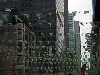
Little Brazil is a small neighborhood in Manhattan, New York City that is centered on the single block of West 46th Street between Fifth and Sixth Avenues. In the 1960s, the street was home to dozens of Brazilian commercial enterprises and Brazilian restaurants, although only a handful remain in the 2000s. It is demarcated by signs between Fifth Avenue and Seventh Avenue, along 46th Street, and several vendors display the green and yellow colors of the Brazilian flag.

<span class="mw-page-title-main">Father Demo Square</span> Square in Manhattan, New York

Father Demo Square is a 0.25-acre (0.10-hectare) triangular park and piazza bounded by Sixth Avenue, Bleecker Street, and Carmine Street in the South Village neighborhood of Lower Manhattan, New York City. The park is named for Father Antonio Demo, who was the pastor of the neighboring Our Lady of Pompeii Church from 1897 to 1935. The church was relocated to Carmine Street in 1926–1928 to accommodate an extension of Sixth Avenue south of Bleecker Street, which created the triangular plot of land. The park, located opposite Carmine Street from the church, was established in 1923 with the Sixth Avenue extension and the land was improved as a park, being named in a tribute to Demo.

<span class="mw-page-title-main">M86 (New York City bus)</span> Bus route in Manhattan, New York

The 86th Street Crosstown Line is a bus line in Manhattan, New York City, running mostly along 86th Street on the Upper West and Upper East Sides of Manhattan. Originally a streetcar line, it now comprises the M86 Select Bus Service bus line.

References

Notes

  1. Google (January 8, 2017). "96th Street" (Map). Google Maps . Google. Retrieved January 8, 2017.
  2. "Remarks of the Commissioners for Laying out Streets and Roads in the City of New York, under the Act of April 3, 1807" Archived June 10, 2007, at the Wayback Machine , accessed May 2, 2007. "These streets are all sixty feet wide except fifteen, which are one hundred feet wide, viz.: Numbers fourteen, twenty-three, thirty-four, forty-two, fifty-seven, seventy-two, seventy-nine, eighty-six, ninety-six, one hundred and six, one hundred and sixteen, one hundred and twenty-five, one hundred and thirty-five, one hundred and forty-five, and one hundred and fifty-five—the block or space between them being in general about two hundred feet."
  3. "Steam" Archived August 13, 2007, at the Wayback Machine Gotham Gazette (November 10, 2003)
  4. "Steam Energy" (PDF). Con Edison . Retrieved July 5, 2017.
  5. McKenzie, Trista (October 28, 2012). "NYC Evacuation Zones: Bloomberg Orders 'Zone A' Residents to Evacuate". All Media NY.
  6. Hinds, Michael DeCourcy (May 13, 1984). "Battling to Control E. 96th Growth". The New York Times . Retrieved December 5, 2007. East 96th Street is not just a dead piece of real estate – it is a socially important corridor,' said August Heckscher. 'With El Barrio to the north and Yorkville to the south, it could be the meeting place of two cultures, a river into which both flow.
  7. Lee, Denny (July 21, 2002). "Neighborhood Report: East Harlem: A 'Museo' Moves Away From Its Barrio Identity". The New York Times . Retrieved December 5, 2007. The neighborhood north of East 96th Street is sometimes called East Harlem or Spanish Harlem, but local Puerto Ricans affectionately call it El Barrio.
  8. Schlossberg, Tatiana (October 2, 2014). "Promise of New Subways Has West Siders Excited and East Siders Skeptical". The New York Times . Retrieved October 26, 2014.
  9. Hughes, C.J. (April 8, 2016). "Yorkville Bets on the Second Avenue Subway". The New York Times . Retrieved April 13, 2016.
  10. "Taxis · NYC311".
  11. Cohen, Joyce (September 3, 2000). "If You're Thinking of Living On/Central Park West; At Every Front Door, a Great Playground". The New York Times . Retrieved December 5, 2007. North of 96th Street, where the area is known as Manhattan Valley, the avenue turns more modest, with a mix of co-ops, condominiums and rentals.
  12. Nieves, Evelyn (December 25, 1990). "Manhattan Valley's Long Awaited Boom Ends Up Just a Fizzle". The New York Times . Retrieved December 5, 2007. For the last 10 years, Manhattan Valley, a quick dip between the Upper West Side and Harlem.
  13. "Japanese Garden Theatre" on the New York City Chapter of the American Guild of Organists website
  14. Duger, Celia W. (July 15, 1994). "Larry Hogue Is Arrested In Westchester". The New York Times .
  15. Remizowski, Leigh; Millat, Caitlin; Lauinger, John (May 30, 2009). "The Wild Man of 96th St., Larry Hogue, caught by police on Upper West Side". New York Daily News .
  16. Panero, James (August 8, 2012). "Upper West Side Madness". City Journal .
  17. 1 2 3 4 "Subway Map" (PDF). Metropolitan Transportation Authority. September 2021. Retrieved September 17, 2021.