Mulberry Street (Manhattan)

Last updated
Mulberry Street
Mulberry Street.jpg
Mulberry Street in 2012
Mulberry Street (Manhattan)
North end Bleecker Street
South end Worth Street
East Mott Street
West Baxter Street
Mulberry Street, c. 1900 NYC Mulberry Street 3g04637u.jpg
Mulberry Street, c.1900

Mulberry Street is a principal thoroughfare in Lower Manhattan, New York City, United States. It is historically associated with Italian-American culture and history, and in the late 19th and early 20th centuries was the heart of Manhattan's Little Italy.

Contents

The street was listed on maps of the area since at least 1755. The "Bend" in Mulberry, where the street changes direction from southeast to northwest to a northerly direction, was made to avoid the wetlands surrounding the Collect Pond. During the period of the American Revolution, Mulberry Street was usually referred to as "Slaughter-house Street", named for the slaughterhouse of Nicholas Bayard on what is now the southwest corner of Mulberry and Bayard Streets, which was located there until the summer of 1784, when it was ordered to be removed to Corlaer's Hook. [1]

Mulberry Bend, formed by Mulberry Street on the east and Orange Street on the west, was historically part of the core of the infamous Five Points; the southwest corner of Mulberry Bend formed part of the Five Points intersection for which the neighborhood was named. Aside from Mulberry, the other four streets forming Five Points were Anthony Street (now Worth Street), Cross Street (now Mosco Street), Orange Street (now Baxter Street), and Little Water Street (which no longer exists). [2]

Location

Mulberry is located between Baxter and Mott Streets. It runs north to south, through the centers of Little Australia and Little Italy, parallel to Mott Street one block to the east, is bound on the north by Bleecker Street in NoHo and on the south by Worth Street in the Civic Center. Near the southern portion of Mulberry Street, the street enters Chinatown, where it is lined with Chinese green grocers, butcher stores, and fishmongers. [3]

Further south past Bayard Street, on the west side of the street, lies Columbus Park, which was created in 1897. [4] The southwest corner of the park (away from Mulberry Street) is the site of the original Five Points intersection. The east side of the street is now lined with Chinatown's funeral homes.[ citation needed ]

Mulberry Bend

"Bandit's Roost", a Mulberry Street back alley, photographed by Jacob Riis in 1888, a target of police efforts in the 1880s and 1890s Bandits Roost, 59 and a half Mulberry Street.jpg
"Bandit's Roost", a Mulberry Street back alley, photographed by Jacob Riis in 1888, a target of police efforts in the 1880s and 1890s

The street was named after the mulberry trees that once lined Mulberry Bend, [5] the slight bend in Mulberry Street. "Mulberry Bend is a narrow bend in Mulberry Street, a tortuous ravine of tall tenement-houses... so full of people that the throngs going and coming spread off the sidewalk nearly to the middle of the street... The crowds are in the street because much of the sidewalk and all of the gutter is taken up with vendors' stands." [6]

For the urban reformer Jacob Riis, Mulberry Bend epitomized the worst of the city's slums: "A Mulberry Bend Alley" contrasted with "Mulberry Bend becomes a park" were two of the photographs illustrating Jacob Riis's call for renewal in The Battle with the Slum (1902). [7] In response to reformers such as Riis, the city in the 1890s bought out many of the slumlords and replaced tenements with Columbus Park. [8]

Notable buildings

The Puck Building stands near the north end of the street on the southwest corner of Houston Street. Further south is Saint Patrick's Old Cathedral, standing in its churchyard. The Church of the Most Precious Blood, at 113 Baxter Street, was built by Italians, who as new immigrants were not allowed to worship in the main Churches of Transfiguration nor St. Patrick's Old Cathedral. Below Prince Street (no. 247) is the former Ravenite Social Club, where wire taps acquired evidence that sent John Gotti to prison.[ citation needed ]

The Italian American Museum is at 155 Mulberry and Grand Street in the building that used to house the Italian immigrant bank Banca Stabile. [9] [10] [11] [12]

Culture

Social structure

The New York Times sent its reporters to characterize the Little Italy/Mulberry neighborhood in May 1896:

They are laborers; toilers in all grades of manual work; they are artisans, they are junkman, and here, too, dwell the rag pickers....There is a monster colony of Italians who might be termed the commercial or shop keeping community of the Latins. Here are all sorts of stores, pensions, groceries, fruit emporiums, tailors, shoemakers, wine merchants, importers, musical instrument makers....There are notaries, lawyers, doctors, apothecaries, undertakers.... There are more bankers among the Italians than among any other foreigners except the Germans in the city. [13]

Feast of San Gennaro

Festival of the Feast of San Gennaro on Mulberry Street in 2006 06SanGennaroFestival.jpg
Festival of the Feast of San Gennaro on Mulberry Street in 2006

During the Italian-American festival of the Feast of San Gennaro each September, the entire street is blocked off to vehicular traffic for the street fair. The San Gennaro Feast began in 1926 and continues as of 2024. It is the largest Italian-American Festival in New York and possibly the United States.[ citation needed ]

Manhattan's Mulberry Street has been the subject of books, films, and music. For example:

Books
Music

Related Research Articles

<span class="mw-page-title-main">Five Points, Manhattan</span> Neighborhood of Manhattan in New York City

Five Points was a 19th-century neighborhood in Lower Manhattan, New York City. The neighborhood, partly built on low-lying land which had filled in the freshwater lake known as the Collect Pond, was generally defined as being bound by Centre Street to the west, the Bowery to the east, Canal Street to the north, and Park Row to the south. The Five Points gained international notoriety as a densely populated, disease-ridden, crime-infested slum which existed for over 70 years.

<span class="mw-page-title-main">Chinatown, Manhattan</span> Neighborhood in New York City

Manhattan's Chinatown is a neighborhood in Lower Manhattan, New York City, bordering the Lower East Side to its east, Little Italy to its north, Civic Center to its south, and Tribeca to its west. With an estimated population of 90,000 to 100,000 people, Chinatown is home to the highest concentration of Chinese people in the Western Hemisphere. Manhattan's Chinatown is also one of the oldest Chinese ethnic enclaves. The Manhattan Chinatown is one of nine Chinatown neighborhoods in New York City, as well as one of twelve in the New York metropolitan area, which contains the largest ethnic Chinese population outside of Asia, comprising an estimated 893,697 uniracial individuals as of 2017.

<span class="mw-page-title-main">Nolita</span> Neighborhood of Manhattan in New York City

Nolita, sometimes written as NoLIta and deriving from "North of Little Italy", is a neighborhood in the borough of Manhattan in New York City. Nolita is situated in Lower Manhattan, bounded on the north by Houston Street, on the east by the Bowery, on the south roughly by Broome Street, and on the west by Lafayette Street. It lies east of SoHo, south of NoHo, west of the Lower East Side, and north of Little Italy and Chinatown.

<span class="mw-page-title-main">Little Italy, Manhattan</span> Neighborhood in New York City

Little Italy is a neighborhood in Lower Manhattan in New York City, known for its Italian population. It is bounded on the west by Tribeca and Soho, on the south by Chinatown, on the east by the Bowery and Lower East Side, and on the north by Nolita.

<span class="mw-page-title-main">Canal Street (Manhattan)</span> Street in Manhattan, New York

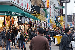
Canal Street is a major east–west street of over 1 mile (1.6 km) in Lower Manhattan, New York City, United States, running from East Broadway between Essex and Jefferson Streets in the east, to West Street between Watts and Spring Streets in the west. It runs through the neighborhood of Chinatown, and forms the southern boundaries of SoHo and Little Italy as well as the northern boundary of Tribeca. The street acts as a major connector between Jersey City, New Jersey, via the Holland Tunnel (I-78), and Brooklyn in New York City via the Manhattan Bridge. It is a two-way street for most of its length, with two unidirectional stretches between Forsyth Street and the Manhattan Bridge.

<span class="mw-page-title-main">Feast of San Gennaro</span> Annual Christian festival of Saint Januarius

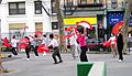
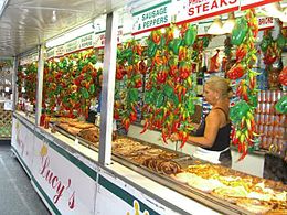
The Feast of San Gennaro, also known as San Gennaro Festival, is a Neapolitan and Italian-American patronal festival dedicated to Saint Januarius, patron saint of Naples and Little Italy, New York.

<span class="mw-page-title-main">Mott Street</span> Street in Manhattan, New York

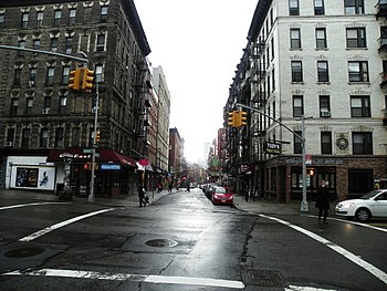
Mott Street is a narrow but busy thoroughfare that runs in a north–south direction in the New York City borough of Manhattan. It is regarded as Chinatown's unofficial "Main Street". Mott Street runs from Bleecker Street in the north to Chatham Square in the south. It is a one-way street with southbound-running vehicular traffic only.

<span class="mw-page-title-main">59th Street (Manhattan)</span> West-east street in Manhattan, New York

59th Street is a crosstown street in the New York City borough of Manhattan, running from York Avenue and Sutton Place on the East Side of Manhattan to the West Side Highway on the West Side. The three-block portion between Columbus Circle and Grand Army Plaza is known as Central Park South, since it forms the southern border of Central Park. There is a gap in the street between Ninth Avenue/Columbus Avenue and Columbus Circle, where the Deutsche Bank Center is located. While Central Park South is a bidirectional street, most of 59th Street carries one-way traffic.

<span class="mw-page-title-main">Centre Street (Manhattan)</span> Street in Manhattan, New York

Centre Street is a north–south street in the New York City borough of Manhattan, running through the Civic Center, Chinatown, and Little Italy neighborhoods of Lower Manhattan. It connects Park Row to the south with Spring Street to the north, where it merges with Lafayette Street. Centre Street carries northbound traffic north of Reade Street and two-way traffic between Reade Street and the Brooklyn Bridge.

<span class="mw-page-title-main">Grand Street (Manhattan)</span> Street in Manhattan, New York

Grand Street is a street in Lower Manhattan, New York City. It runs west/east parallel to and south of Delancey Street, from SoHo through Chinatown, Little Italy, the Bowery, and the Lower East Side. The street's western terminus is Varick Street, and on the east it ends at the service road for the FDR Drive.

<span class="mw-page-title-main">Church of the Most Precious Blood (Manhattan)</span> Church in New York City, United States

The Church of the Most Precious Blood is a Roman Catholic parish located in New York City. The parish is under the authority of the Archdiocese of New York, and is the National Shrine Church of San Gennaro. Located at 113 Baxter Street with an additional entrance on Mulberry Street, the Church of the Most Precious Blood is part of Manhattan's Little Italy neighborhood. The Most Precious Blood parished merged with Old St. Patrick's Cathedral parish, and the two churches share priests and administrative staff.

Perry Criscitelli is an American restaurant owner who is an alleged member of the Bonanno crime family. Criscitelli owns several restaurants and previously managed a popular city street festival.

<span class="mw-page-title-main">Chinatowns in Brooklyn</span> Overview of Chinatowns in Brooklyn

The first Brooklyn Chinatown, was originally established in the Sunset Park area of the New York City borough of Brooklyn. It is one of the largest and fastest growing ethnic Chinese enclaves outside of Asia, as well as within New York City itself. Because this Chinatown is rapidly evolving into an enclave predominantly of Fuzhou immigrants from Fujian Province in China, it is now increasingly common to refer to it as the Little Fuzhou or Fuzhou Town of the Western Hemisphere; as well as the largest Fuzhou enclave of New York City.

<span class="mw-page-title-main">Mulberry Bend</span> Area in Manhattan, New York

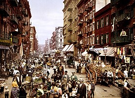
Mulberry Bend was an area surrounding a curve on Mulberry Street, in the Five Points neighborhood in Lower Manhattan, New York City. It is located in what is now Chinatown in Manhattan.

New York City has the largest population of Italian Americans in the United States as well as North America, many of whom inhabit ethnic enclaves in Brooklyn, the Bronx, Manhattan, Queens, and Staten Island. New York is home to the third largest Italian population outside of Italy, behind Buenos Aires, Argentina (first) and São Paulo, Brazil (second). Over 2.6 million Italians and Italian-Americans live in the greater New York metro area, with about 800,000 living within one of the five New York City boroughs. This makes Italian Americans the largest ethnic group in the New York metro area.

<span class="mw-page-title-main">Baxter Street</span> Street in Manhattan, New York

Baxter Street is a narrow thoroughfare that runs in a north–south direction in the borough of Manhattan in New York City in the United States. It lies between Mulberry Street and Centre Street. It runs through Little Italy and the edge of Chinatown. Today, it runs one-way southbound from Grand Street to Hogan Place, and one-way northbound for its southernmost block from Worth Street to Hogan Place.

<span class="mw-page-title-main">Columbus Park (Manhattan)</span> Public park in Manhattan, New York

Columbus Park formerly known as Mulberry Bend Park, Five Points Park and Paradise Park, is a public park in Chinatown, Manhattan, in New York City that was built in 1897.

<i>Bandits Roost, 59 1/2 Mulberry Street</i> 1888 photograph by Jacob Riis

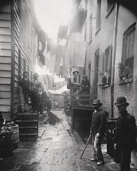
Bandits' Roost, 59 1/2 Mulberry Street is a black and white photograph produced by Danish-American photojournalist and social reformer Jacob Riis in 1888. The photograph was possibly not taken by Riis but instead by one of his assistant photographers, Henry G. Piffard or Richard Hoe Lawrence. It was first published in the photographic book How the Other Half Lives, in 1889, which aimed to document the social conditions of the poorest people of New York.

References

  1. Staff (April 1, 1896). "Abattoirs; History of New-York Slaughter-Houses — Interesting and Curious Data" (PDF). The New York Times .
  2. Herman, Michele "Five Points" in Jackson, Kenneth T., ed. (2010). The Encyclopedia of New York City (2nd ed.). New Haven: Yale University Press. ISBN   978-0-300-11465-2., p.456
  3. Chin, RK. "A Journey Through Chinatown: Mulberry Street". RK Chin Web Gallery. Retrieved April 16, 2015.
  4. "Columbus Park". New York City Department of Parks and Recreation . Retrieved October 27, 2007.
  5. Naureckas, Jim. "Mulberry Street: A New York Songline". New York Songlines. Retrieved April 16, 2015.
  6. Logan, Harlan (1894). "The Bowery and Bohemia". Scribner's Magazine . p. 458.
  7. Max Page devotes a section to "Jacob Riis and the 'leprous houses' of Mulberry Bend" in The Creative Destruction of Manhattan, 1900-1940, 2001:73ff
  8. Fernando, Nisha (2007). Culture and Identity in Urban Streets: A Case Study of Chinatown, New York City. p. 111. ISBN   9780549437819.
  9. In Little Italy, a Former Bank Will Now Hold Italian Immigrants' Memories, The New York Times, September 8, 2008
  10. Warerkar, Tanay (2018-01-17). "First look at Little Italy's revamped Italian American Museum". Curbed NY. Retrieved 2021-10-23.
  11. Kaufman, Joanne (2021-10-13). "Bricks Return With Style in New High-End Buildings". The New York Times. ISSN   0362-4331 . Retrieved 2021-10-23.
  12. "Home". Italian American Museum. Retrieved 2021-10-23.
  13. Staff (May 31, 1896). "Little Italy in New-York". The New York Times . p. 32.
  14. "Billy Joel, AXS TV, Jazz Fest Release 'Big Man On Mulberry Street' Performance". BillyJoel.com. May 20, 2013.

Further reading

See also

40°43′13″N73°59′49″W / 40.7202°N 73.9970°W / 40.7202; -73.9970