Manhattan's Chinatown is a neighborhood in Lower Manhattan, New York City, bordering the Lower East Side to its east, Little Italy to its north, Civic Center to its south, and Tribeca to its west. With an estimated population of 90,000 to 100,000 people, Chinatown is home to the highest concentration of Chinese people in the Western Hemisphere. Manhattan's Chinatown is also one of the oldest Chinese ethnic enclaves. The Manhattan Chinatown is one of nine Chinatown neighborhoods in New York City, as well as one of twelve in the New York metropolitan area, which contains the largest ethnic Chinese population outside of Asia, comprising an estimated 893,697 uniracial individuals as of 2017.

The Dual Contracts, also known as the Dual Subway System, were contracts for the construction and/or rehabilitation and operation of rapid transit lines in the City of New York. The contracts were signed on March 19, 1913, by the Interborough Rapid Transit Company and the Brooklyn Rapid Transit Company. As part of the Dual Contracts, the IRT and BRT would build or upgrade several subway lines in New York City, then operate them for 49 years.
The Second Avenue Subway is a New York City Subway line that runs under Second Avenue on the East Side of Manhattan. The first phase of this new line, with three new stations on Manhattan's Upper East Side, opened on January 1, 2017. The full Second Avenue Line, if it will be funded, will be built in three more phases to eventually connect Harlem–125th Street in Harlem to Hanover Square in Lower Manhattan. The proposed full line would be 8.5 miles (13.7 km) and 16 stations long, serve a projected 560,000 daily riders, and cost more than $17 billion.

Union Square is a historic intersection and surrounding neighborhood in Manhattan, New York City, United States, located where Broadway and the former Bowery Road – now Fourth Avenue – came together in the early 19th century. Its name denotes that "here was the union of the two principal thoroughfares of the island". The current Union Square Park is bounded by 14th Street on the south, 17th Street on the north, and Union Square West and Union Square East to the west and east respectively. 17th Street links together Broadway and Park Avenue South on the north end of the park, while Union Square East connects Park Avenue South to Fourth Avenue and the continuation of Broadway on the park's south side. The park is maintained by the New York City Department of Parks and Recreation.
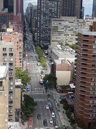
Second Avenue is located on the East Side of the New York City borough of Manhattan extending from Houston Street at its south end to the Harlem River Drive at 128th Street at its north end. A one-way street, vehicular traffic on Second Avenue runs southbound (downtown) only, except for a one-block segment of the avenue in Harlem. South of Houston Street, the roadway continues as Chrystie Street south to Canal Street.

Sixth Avenue – also known as Avenue of the Americas, although this name is seldom used by New Yorkers – is a major thoroughfare in New York City's borough of Manhattan, on which traffic runs northbound, or "uptown". It is commercial for much of its length.

The IRT Third Avenue Line, commonly known as the Third Avenue Elevated, Third Avenue El, or Bronx El, was an elevated railway in Manhattan and the Bronx, New York City. Originally operated by the New York Elevated Railway, an independent railway company, it was acquired by the Interborough Rapid Transit Company (IRT) and eventually became part of the New York City Subway system.

The 34th Street–Herald Square station is an underground station complex on the BMT Broadway Line and the IND Sixth Avenue Line of the New York City Subway. It is located at Herald Square in Midtown Manhattan where 34th Street, Broadway and Sixth Avenue intersect, and is served by the D, F, N, and Q trains at all times; the R train at all times except late nights; the B, M, and W trains on weekdays; and the <F> train during rush hours in the peak direction.

The IRT Second Avenue Line, also known as the Second Avenue Elevated or Second Avenue El, was an elevated railway in Manhattan, New York City, United States, from 1878 to 1942. It was operated by the Interborough Rapid Transit Company until 1940, when the city took over the IRT. Service north of the 57th Street station ended on June 11, 1940; the rest of the line closed on June 13, 1942.

The 47th–50th Streets–Rockefeller Center station is an express station on the IND Sixth Avenue Line of the New York City Subway. It is located along Sixth Avenue between 47th and 50th Streets, on the west side of Rockefeller Center. The station is served by the D and F trains at all times, the B and M trains on weekdays, and the <F> train during rush hours in the peak direction. In 2019, it was the 12th busiest subway station in the system.
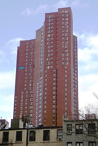
Confucius Plaza Apartments is a limited-equity housing cooperative in Chinatown, Manhattan, New York City. The 44-story brown brick tower block complex with 762 apartments was constructed in 1975 at a cost of $38.387 million. The building was the first major public-funded housing project built for almost exclusively Chinese Americans.
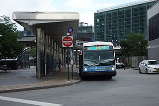
The First and Second Avenues Line, also known as the Second Avenue Line, is a bus line in Manhattan, New York City, running mostly along Second Avenue from Lower Manhattan to East Harlem. Originally a streetcar line along Second Avenue, it is now the M15 bus route, the busiest bus route in the city and United States, carrying 16.4 million riders annually. MTA Regional Bus Operations, under the New York City Bus and Select Bus Service brands, operates the local out of the Tuskegee Airmen Bus Depot and the SBS from the Mother Clara Hale Bus Depot. Service is operated exclusively with articulated buses.

Allen Street is a street in the New York City borough of Manhattan which runs north-south through the Lower Manhattan neighborhood of Chinatown and the Lower East Side. It is continued north of Houston Street as First Avenue. South of Division Street, it is known as Pike Street to its southern terminus at South Street. The northbound and southbound roadways are separated by a meridian mall, which has two bike lanes located outside the meridian mall; each bike lane is unidirectional. The street's namesake was Master Commandant William Henry Allen, the youngest person to command a Navy ship in the War of 1812. He was killed in action at the age of 28. His exploits included the capture of the British ship HMS Macedonian.

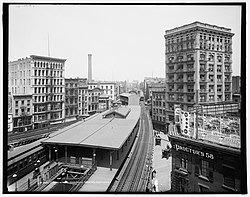
The Fordham Road–190th Street station was an express station on the demolished IRT Third Avenue Line in the Bronx, New York City. It was located at Fordham Road and Third Avenue, one block east of Webster Avenue, in the modern location of Fordham Plaza. Opened in 1901, the station was closed in 1973 and demolished in 1977 along with the rest of the Third Avenue Line. No trace of the station exists today.
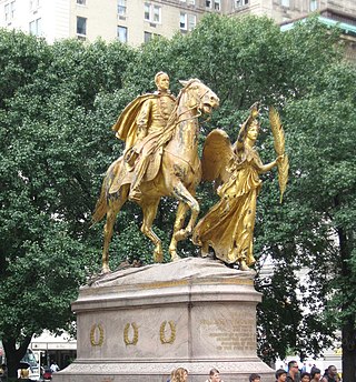
Grand Army Plaza is a square at the southeast corner of Central Park in Manhattan, New York City, at the intersection of Fifth Avenue and Central Park South, covering two blocks on the west side of Fifth Avenue between 58th and 60th Streets. It contains an equestrian statue of William Tecumseh Sherman on its northern half and the Pulitzer Fountain on its southern half.

East Broadway is a two-way east–west street in the Chinatown, Two Bridges, and Lower East Side neighborhoods of the New York City borough of Manhattan in the U.S. state of New York.

Vietnam Veterans Plaza is an American memorial plaza in Manhattan, New York. It honors New York City citizens who served during the 20th-century Vietnam War.
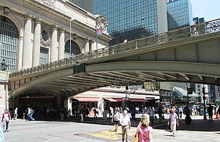
Pershing Square is a public plaza in Manhattan, New York City, located where Park Avenue and 42nd Street intersect in front of Grand Central Terminal. The main roadway of Park Avenue crosses over 42nd Street on the Park Avenue Viaduct, also known as the Pershing Square Viaduct. Two service roads, one northbound and one southbound, connect 42nd Street with the main roadway of Park Avenue, at 40th Street.

The Second Avenue Subway, a New York City Subway line that runs under Second Avenue on the East Side of Manhattan, has been proposed since 1920; the first phase of the line did not open until 2017. Up until the 1960s, many distinct plans for the Second Avenue subway line were never carried out, though small segments were built in the 1970s. The complex reasons for these delays are why the line is sometimes called "the line that time forgot".