Mersing District

Last updated

Mersing District
Daerah Mersing
Other transcription(s)
   Jawi مرسيڠ
   Chinese 丰盛港县
   Tamil மெர்சிங்
Flag of Mersing, Johor.svg
Mersing highlighted in Johor, Malaysia.svg
Location of Mersing District in Johor
Mersing District
Malaysia location map with districts.svg
Red pog.svg
Mersing District
Location of Mersing District in Malaysia
Coordinates: 2°20′N103°40′E / 2.333°N 103.667°E / 2.333; 103.667
Country Flag of Malaysia 23px.svg  Malaysia
State Flag of Johor.svg  Johor
Seat Mersing
Local area government(s) Mersing District Council
Government
  District officerAsman Shah bin Abd Rahman
Area
[1]
  Total2,838.47 km2 (1,095.94 sq mi)
Population
 (2010) [2]
  Total64,094
  Density23/km2 (58/sq mi)
Time zone UTC+8 (MST)
  Summer (DST) UTC+8 (Not observed)
Postcode
86xxx
Calling code +6-07
Vehicle registration plates J

Mersing District is one of the 10 districts district in Johor, Malaysia. Its seat is located at Mersing Town.

Contents

Etymology

The “Mersing” name is derived from the Chinese “Mau Sheng Port” (茂盛港) since 1880 and further simplify to Mersing. Mersing's Chinese name was renamed to “Feng Sheng Port” (丰盛港), with the meaning of good harvest. There are also said that Mersing's name is derived from Sikh traders who named Amir Singh and Men Singh. [3]

Geology

Beside the mainland area, the district also consists of 36 islands. [4]

Geography

With an area of 2,838 km2, Mersing District is the third largest district in Johor, which covers 14.6% area of the state.

Demographics

Historical population
YearPop.±%
1991 63,643    
2000 67,605+6.2%
2010 69,028+2.1%
2020 78,195+13.3%
Source: [5]

In 2000, the annual population growth of the district was 1.21%. [6]

Federal Parliament and State Assembly Seats

List of Mersing district representatives in the Federal Parliament (Dewan Rakyat)

ParliamentSeat NameMember of ParliamentParty
P154 Mersing Muhammad Islahuddin Abas Perikatan Nasional (PPBM)

List of Mersing district representatives in the State Legislative Assembly.

ParliamentStateSeat NameState AssemblymanParty
P154N32 Endau Alwiyah TalibPerikatan Nasional (PPBM)
P154N33 Tenggaroh Raven Kumar KrishnasamyBarisan Nasional (MIC)

Administrative divisions

Map of Mukims of Mersing District. Map of Mersing District, Johor.svg
Map of Mukims of Mersing District.

Mersing District is divided into 10 mukims, which are: [1]

Economy

The main economy activities in the district are ecotourism, fishery, marine activities, agriculture and light manufacturing. [8]

Tourist attractions

Transportation

See also

Related Research Articles

<span class="mw-page-title-main">Kluang District</span> District in Johor, Malaysia

The Kluang District is a district in Johor, Malaysia. Its district capital is Kluang Town. Kluang district is one of the three landlocked districts in Johor, the other being Segamat and Kulai.

<span class="mw-page-title-main">Johor Bahru District</span> District in Johor, Malaysia

The Johor Bahru District is a district located in the southern part of Johor, Malaysia. The heavily suburban/suburbanizing district covers an area of 1,063.97 km2 (410.80 sq mi) and has a population of 1.71 million. The district capital is Johor Bahru City and the administrative capital is Iskandar Puteri City. The district borders Pontian District on the west, Kota Tinggi District on the east, Kulai District on the north and Straits of Johor to the south. The urban centres are divided into the cities of Johor Bahru, Iskandar Puteri and Pasir Gudang.

<span class="mw-page-title-main">Segamat District</span> District in Johor, Malaysia

The Segamat District or simply Segamat is a district in the Malaysian state of Johor. Segamat is also the name of the district's primary town. Segamat district is one of the three landlocked districts in Johor, the other being Kluang and Kulai.

<span class="mw-page-title-main">Rawa Island</span> Island of Malaysia

Rawa Island is a coral island in Mersing District, Johor, Malaysia. Nearby islands include Harimau and Mensirip.

<span class="mw-page-title-main">Sibu Island</span> Island group in Mersing District, Johor, Malaysia.

Sibu Island is an island group in Mersing District, Johor, Malaysia.

<span class="mw-page-title-main">Besar Island, Johor</span> Island in Mersing District, Johor, Malaysia

Besar Island, also known as Babi Besar Island is an island in Mersing District, Johor, Malaysia.

Taman Universiti is a suburb in Iskandar Puteri, Johor Bahru District, Johor, Malaysia. It is located between Skudai and Pulai.

<span class="mw-page-title-main">Mersing</span> Town and district capital in Johor, Malaysia

Mersing is a town, mukim and the capital of Mersing District, Johor, Malaysia. The town is located at the southern end of the east coast of Peninsular Malaysia. As of 2010, the town has an estimated population of 70,894.

<span class="mw-page-title-main">Endau</span> Town in Mersing, Johor, Malaysia

Endau is a small town in Mersing District, Johor, Malaysia. It lies on the northern tip of east Johor, on the border with the Pahang state.

<span class="mw-page-title-main">Pontian District</span> District in Johor, Malaysia

Pontian District is a district located in southwest part of the Malaysian state of Johor. It borders Batu Pahat and Kluang Districts to the north and Kulai and Johor Bahru Districts to the east.

<span class="mw-page-title-main">Malaysia Federal Route 3</span> Road in Malaysia

Federal Route 3 is a main federal road running along the east coast of Peninsula Malaysia. The 739 kilometres (459 mi) federal highway connects Rantau Panjang in Kelantan until Johor Bahru in Johor. The entire FT3 highway is gazetted as a part of the Asian Highway Network route 18.

The state of Johor in Malaysia is noted for its national parks and forest reserves which preserve virgin rainforests known for its biodiversity and endangered species of animals. Mangrove swamps and coral reefs are also protected within these parks.

<span class="mw-page-title-main">Endau-Rompin National Park</span>

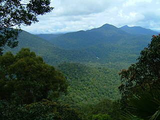
Endau-Rompin National Park is a protected tropical rainforest situated within a massif in the southern foothills of the Tenasserim Hills, straddling Segamat and Mersing Districts in northeastern Johor and Rompin District in southern Pahang. It covers a total land area of approximately 870 km2 (340 sq mi), making it the second-largest national park in Peninsular Malaysia after Taman Negara. It has approximately 26 km (16 mi) of trail. It is the second national park proclaimed by the government of Malaysia. Gunung Besar, the second-highest peak in Johor, is in the park.

<span class="mw-page-title-main">Johor</span> State of Malaysia

Johor is a state of Malaysia in the south of the Malay Peninsula. It borders with Pahang, Malacca and Negeri Sembilan to the north. Johor has maritime borders with Singapore to the south and Indonesia to the east and west. As of 2023, the state's population is 4.19 million, making it the second most populous state in Malaysia, after Selangor. Johor Bahru is the capital city and the economic centre of the state, Kota Iskandar is the state administrative centre and Muar serves as the royal capital.

<span class="mw-page-title-main">Kota Tinggi District</span> District in Johor, Malaysia

Kota Tinggi District is a district in the Malaysian state of Johor. It is the largest district in the state with an area of 3,488.7 square kilometres (1,347.0 sq mi). The population was 187,824 in 2010. The principal town is Kota Tinggi.

<span class="mw-page-title-main">Aur Island</span> Island in Mersing District, Johor, Malaysia

The Aur Island is an island in Mersing District, Johor, Malaysia. It lies about 76 kilometres (47 mi) east of Mersing Town and is part of the Johor Marine Park. Its corals, lagoons and offshore pools make it a tourist attraction. It has for many years also been a frequent stopover point for fishermen.

Dayang Island is an island in Mersing District, Johor, Malaysia. It is one of a group of islands along with Pulau Aur, Pulau Lang and Pulau Pemanggil. The name of the neighbouring island, Pulau Aur, means "bamboo island" in Malay and both islands have been known to Chinese sailors for centuries. A map from the 17th century identified them as East and West Bamboo islands.

<span class="mw-page-title-main">Kota Johor Lama Museum</span> Museum in Kota Tinggi, Johor, Malaysia

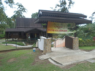
The Kota Johor Lama Museum is a museum in Johor Lama, Kota Tinggi District, Johor, Malaysia. The museum is about the history of Johor Lama.

References

  1. 1 2 "Pejabat Tanah Mersing". ptj.johor.gov.my.
  2. "Population Distribution and Basic Demographic Characteristics, 2010" (PDF). Department of Statistics, Malaysia. Archived from the original (PDF) on 22 May 2014. Retrieved 19 April 2012.
  3. "【柔佛10县名字由来】柔佛子民随堂考:10县名字由来,知道一半以上算你牛". JOHOR NOW 就在柔佛. 24 May 2017.
  4. "Kedudukan Geografi". Portal Rasmi Majlis Daerah Mersing (in Malay). 22 December 2015. Retrieved 23 January 2018.
  5. "Key Findings of Population and Housing Census of Malaysia 2020" (pdf) (in Malay and English). Department of Statistics, Malaysia. ISBN   978-967-2000-85-3.
  6. Handbook johor.gov.my
  7. "GeoJohor" . Retrieved 27 October 2018.
  8. "Muafakat ke Arah #Johor Berkemajuan" (PDF). Muafakat Johor (in Malay). Retrieved 17 March 2018.