Pontian District

Last updated

Pontian District
Daerah Pontian
Other transcription(s)
   Jawi فونتيان
   Chinese 笨珍县
   Tamil பொந்தியான்
Flag of Pontian, Johor.svg
Coat of arms of Pontian Municipal Council.png
Pontian highlighted in Johor, Malaysia.svg
Location of Pontian District in Johor
Pontian District
Malaysia location map with districts.svg
Red pog.svg
Pontian District
Location of Pontian District in Malaysia
Coordinates: 1°35′N103°25′E / 1.583°N 103.417°E / 1.583; 103.417
Country Flag of Malaysia 23px.svg  Malaysia
State Flag of Johor.svg  Johor
Granted
Municipal Status
31 July 2021
Seat Pontian Kechil
Local area government(s) Pontian Municipal Council
Government
  District officerHaji Zulkifly bin Haji Mohd Tahir
   Pontian Member of Parliament Ahmad Maslan (UMNO)
Area
[1]
  Total932.64 km2 (360.09 sq mi)
Population
 (2010) [2]
  Total144,324
  Density150/km2 (400/sq mi)
Time zone UTC+8 (MST)
  Summer (DST) UTC+8 (Not observed)
Postcode
82xxx
Calling code +6-07
Vehicle registration plates J
Pontian Municipal Council

Majlis Perbandaran Pontian
مجليس ڤربندرن ڤونتين
Coat of arms of Pontian Municipal Council.png
Type
Type
History
Founded31 July 2021
Preceded byPontian District Council
Leadership
President
Mohd Ezzuddin Sanusi
Municipal Secretary
Hisyamuddin Amat
Motto
Setia Khidmat/ستيا خدمت
(Loyal, Service)
Meeting place
Pontian District Council.jpg
Jalan Alsagoff, 82000 Pontian,Johor Darul Ta'zim
Website
www.mppn.gov.my
Coat of arms of Pontian District Council, predecessor of Pontian Municipal Council. The Seal of Pontian District Council.jpg
Coat of arms of Pontian District Council, predecessor of Pontian Municipal Council.

Pontian District (Malay : Daerah Pontian) is a district located in southwest part of the Malaysian state of Johor. It borders Batu Pahat and Kluang Districts to the north and Kulai and Johor Bahru Districts to the east. [3]

Contents

The district is home to Tanjung Piai, the southernmost point of the Malay Peninsula and mainland Eurasia as a whole.

Etymology

The name of Pontian was derived from the Malay word “Perhentian” which means a stop, a reference to the sailors travelling to and from Singapore or Malacca stopping at Pontian Besar River for shelter from the rough waters in the Strait of Malacca. [4]

Administrative divisions

Map of Pontian District, Johor.svg

Pontian District is divided into 11 mukims, which are: [5]

Federal Parliament and State Assembly Seats

List of Pontian district representatives in the Federal Parliament (Dewan Rakyat):

ParliamentSeat NameMember of ParliamentParty
P164 Pontian Ahmad Maslan Barisan Nasional (UMNO)
P165 Tanjung Piai Wee Jeck Seng Barisan Nasional (MCA)

List of Pontian district representatives in the State Legislative Assembly (Dewan Undangan Negeri):

ParliamentStateSeat NameState AssemblymanParty
P164N53 Benut Hasni Mohammad Barisan Nasional (UMNO)
P164N54 Pulai Sebatang Hasrunizzah HassanBarisan Nasional (UMNO)
P165N55 Pekan Nanas Tan Eng MengBarisan Nasional (MCA)
P165N56 Kukup Jefridin Atan Barisan Nasional (UMNO)

Demographics

Historical population
YearPop.±%
1991 129,356    
2000 142,697+10.3%
2010 149,938+5.1%
2020 173,318+15.6%
Source: [6]

In 2000, the annual population growth of Pontian District was 2.36%. [7]

Economy

The main economic activities in the district are agriculture, construction, ecotourism, fishery and marine and food processing industries. The former includes pineapple farms and palm oil plantations, which are mainly focused in the town of Pekan Nanas. [8] [9] [10]

Transportation

Road

The district is accessible by bus from Larkin Sentral (Mybas Johor- T50, Maju - 96) in Johor Bahru. [11] [12]

Sea

There are regularly scheduled ferries connecting fishing village Kukup in Serkat Mukim with Tanjung Balai Karimun in Riau Islands, Indonesia. [13]

Related Research Articles

<span class="mw-page-title-main">Batu Pahat District</span> District in Johor, Malaysia

The Batu Pahat District is a district in the state of Johor, Malaysia. It lies southeast of Muar, southwest of Kluang, northwest of Pontian, south of Segamat and Tangkak District. The capital of the district is Bandar Penggaram.

<span class="mw-page-title-main">Johor Bahru District</span> District in Johor, Malaysia

The Johor Bahru District is a district located in the southern part of Johor, Malaysia. The heavily suburban/suburbanizing district covers an area of 1,063.97 km2 (410.80 sq mi) and has a population of 1.71 million. The district capital is Johor Bahru City and the administrative capital is Iskandar Puteri City. The district borders Pontian District on the west, Kota Tinggi District on the east, Kulai District on the north and Straits of Johor to the south. The urban centres are divided into the cities of Johor Bahru, Iskandar Puteri and Pasir Gudang.

<span class="mw-page-title-main">Segamat District</span> District in Johor, Malaysia

The Segamat District or simply Segamat is a district in the Malaysian state of Johor. Segamat is also the name of the district's primary town. Segamat district is one of the three landlocked districts in Johor, the other being Kluang and Kulai.

<span class="mw-page-title-main">Kukup</span> Village in Malaysia

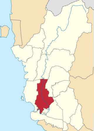
Kukup is a small fishing village in Pontian District, Johor, Malaysia. It is famous for its open-air seafood restaurants built on stilts over the water. Regularly scheduled ferries connect Kukup with Tanjung Balai in Indonesia.

<span class="mw-page-title-main">Mersing</span> Town and district capital in Johor, Malaysia

Mersing is a town, mukim and the capital of Mersing District, Johor, Malaysia. The town is located at the southern end of the east coast of Peninsular Malaysia. As of 2010, the town has an estimated population of 70,894.

<span class="mw-page-title-main">Kinta District</span> District of Malaysia in Perak

The Kinta District is a district in Perak, Malaysia. It contains the state capital Ipoh. Kinta is the most populated district in Perak and also the seventh most populated district in Malaysia. Kinta houses Ipoh, Perak's largest city and state capital while Batu Gajah is a seat in Kinta district.

<span class="mw-page-title-main">Batang Padang District</span> District of Malaysia in Perak

The Batang Padang District is a district in Perak, Malaysia. This district is administered by a local council, namely, the Tapah District Council, based in Tapah. The major towns of Batang Padang are Bidor, Tapah and Sungkai.

<span class="mw-page-title-main">Hulu Perak District</span> District of Malaysia in Perak

Hulu Perak District is a district in Perak, Malaysia. It is the largest district in Perak. In the east of the district it borders the districts of Jeli and Gua Musang in Kelantan, to the west it borders Baling and Kulim Districts of Kedah, to the south it borders the district of Kuala Kangsar while to the south-west it borders the district of Larut, Matang and Selama. Hulu Perak also shares a border with Yala Province's Betong District beyond the border with Thailand. The seat of the district is Gerik, which is also the largest town of the district.

<span class="mw-page-title-main">Perak Tengah District</span> District of Malaysia in Perak

Perak Tengah District is a district in Perak, Malaysia. It is administered by the Perak Tengah District Council, which is based at the town of Seri Iskandar. Parit is however the largest settlement in the area. The district is well known for its historical sites in the Pasir Salak. Smaller towns in the district include Bota, Lambor and Kampung Gajah.

<span class="mw-page-title-main">Alor Gajah District</span> District in Melaka, Malaysia

Alor Gajah District is one of the three administrative districts in Malacca, Malaysia. It borders Tampin District, Rembau District and Port Dickson District in Negeri Sembilan to the north and borders Jasin District and Melaka Tengah District in the east and south respectively.

<span class="mw-page-title-main">Pontian Kechil</span> Town and district capital in Johor, Malaysia

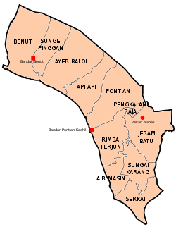
Pontian Kechil also known as Pontian Town is a town and the administrative centre of Pontian District, Johor, Malaysia.

<span class="mw-page-title-main">Plentong</span> Mukim in Johor, Malaysia

Plentong is a mukim in Johor Bahru District, Johor, Malaysia.

<span class="mw-page-title-main">Tangkak District</span> District in Johor, Malaysia

The Tangkak District is a district in western Johor, Malaysia, bordering Muar District to the south, Segamat District to the northeast, and Jasin District, Malacca to the west. The district also shares a 11 kilometre border with Tampin District, Negeri Sembilan to the northwest. The district capital and largest settlement is the town of Tangkak. Other towns include Sagil, Sungai Mati and Tanjung Agas.

<span class="mw-page-title-main">Larut, Matang and Selama District</span> District of Perak, Malaysia

The Larut, Matang and Selama District is a district of Perak, Malaysia. Taiping is the capital town of this district. Larut, Matang and Selama used to be three small different districts and they merged into one larger district later. Larut, Matang and Selama houses Taiping, Perak's second largest city and former state capital. Other towns in the region include Changkat Jering, Terong, Matang, Kuala Sepetang and Selama. The region borders the state of Kedah on the north, the Kerian District on the northwest, the Hulu Perak and Kuala Kangsar District on the east, and the Manjung District on the south.

<span class="mw-page-title-main">Kulai District</span> District in Johor, Malaysia

The Kulai District is a district in the state of Johor, Malaysia. Its district capital is Kulai Town. It covers Kulai Town, Ayer Bemban, Bandar Putra Kulai, Bukit Batu, Indahpura, Bandar Baru Kangkar Pulai, Kelapa Sawit, Saleng, Sedenak, Seelong, Senai, and Sengkang. Kulai is also within Iskandar Malaysia economic zone.

<span class="mw-page-title-main">Muar District</span> District in Johor, Malaysia

The Muar District is a district in Johor, Malaysia. Muar is located at the mouth of the Muar River, on the coast of the Straits of Malacca. The Muar District covers 1,354 km2 (523 sq mi), with a population of 233,779 (2010).

<span class="mw-page-title-main">Iskandar Malaysia</span> Growth corridor and metropolitan area in Johor, Malaysia

Iskandar Malaysia, formerly known as Iskandar Development Region (IDR; Malay: Wilayah Pembangunan Iskandar) and South Johor Economic Region (SJER), is the main southern development corridor in Johor, Malaysia. It was established on 8 November 2006. Iskandar Malaysia, which is formed by major cities such as Johor Bahru, Iskandar Puteri and Pasir Gudang, is part of the Johor Bahru Conurbation. It also lies within the original Indonesia–Malaysia–Singapore growth triangle, along with Singapore and Riau, Indonesia.

<span class="mw-page-title-main">Kota Tinggi District</span> District in Johor, Malaysia

Kota Tinggi District is a district in the Malaysian state of Johor. It is the largest district in the state with an area of 3,488.7 square kilometres (1,347.0 sq mi). The population was 187,824 in 2010. The principal town is Kota Tinggi.

<span class="mw-page-title-main">Rembau District</span> District in Negeri Sembilan, Malaysia

The Rembau District is a district that is located in the state of Negeri Sembilan, Malaysia. The district is a stronghold of the matrilineal system known as adat perpatih, a customary practice inherited from the Minangkabaus, of Sumatra. The district borders Seremban District to the north, Port Dickson District to the west, Tampin District to the east, Kuala Pilah District to the northeast and Alor Gajah District, Malacca to the southwest.

References

  1. "Rancangan Tempatan Daerah Pontian (Penggantian) 2030" (ZIP) (in Malay).
  2. "Population Distribution and Basic Demographic Characteristics, 2010" (PDF). Department of Statistics, Malaysia. Archived from the original (PDF) on 22 May 2014. Retrieved 19 April 2012.
  3. "Pontian". tourismjohor.my. 16 August 2021.
  4. "Pontian". tourism.johor.my. Archived from the original on 24 December 2018.
  5. "Pejabat Tanah Pontian" [Pontian Land Office]. Pentadbiran Tanah Johor (in Malay). Archived from the original on 19 July 2021. Retrieved 22 July 2021.
  6. "Key Findings of Population and Housing Census of Malaysia 2020" (pdf) (in Malay and English). Department of Statistics, Malaysia. ISBN   978-967-2000-85-3.
  7. "Johor State Town and Country Planning Department Handbook" (PDF).
  8. "Pontian". Tourism Johor. Archived from the original on 24 December 2018. Retrieved 21 February 2018.
  9. Benjamin, Nelson (15 January 2018). "A positive change in its fortunes". The Star Online. Retrieved 19 January 2018.
  10. "Muafakat ke Arah #Johor Berkemajuan" (PDF). Muafakat Johor (in Malay). Archived from the original (PDF) on 17 March 2018. Retrieved 17 March 2018.
  11. "Bus Routes in Johor Bahru". BusInterchange.net. Retrieved 24 November 2017.
  12. "Bus Routes and Schedule". Pengangkutan Awam Johor. Retrieved 17 March 2018.
  13. (in Malay) Terminal Feri Kukup kembali sibuk