Montrose, Colorado | |
---|---|
Motto(s): "Quality of Life Is Our Commitment " "Stay here, play everywhere" | |
Location in the United States | |
Coordinates: 38°28′37″N107°51′56″W / 38.47694°N 107.86556°W | |
Country | United States |
State | Colorado |
County | Montrose County [2] |
City | Montrose [1] |
Incorporated | May 1, 1882 [3] |
Government | |
• Type | Home rule municipality [1] |
• Mayor | J. David Reed [4] |
• City Manager | William E. Bell [5] |
• State Representative | Marc Catlin [6] |
Area | |
• Total | 18.48 sq mi (47.9 km2) |
• Land | 18.48 sq mi (47.9 km2) |
• Water | 0.0 sq mi (0 km2) |
Elevation | 5,807 ft (1,770 m) |
Population | |
• Total | 20,291 |
• Density | 1,098.2/sq mi (424.0/km2) |
Time zone | UTC−7 (MST) |
• Summer (DST) | UTC−6 (MDT) |
ZIP codes [10] | 81401, 81402 (PO Box), 81403 |
Area code | 970 |
FIPS code | 08-51745 |
GNIS feature ID | 203328 [8] |
Website | www |
Montrose is a home rule municipality that is the county seat and the most populous municipality of Montrose County, Colorado, United States. [11] The city population was 20,291 at the 2020 census, [9] within a total area of 18.5 square miles. [7] The main road that leads in and out of Montrose is U.S. Highway 50. The city is located in western Colorado, in the Uncompahgre Valley, and is an economic, labor, and transportation waypoint for the surrounding area. [12] Montrose is the second-largest city in western Colorado, after Grand Junction.
In 2022, Montrose was ranked in the top-25 of the nation's most dynamic micropolitan statistical areas by think tank Heartland Forward largely due to its outdoor recreation access. [13]
Montrose was incorporated on May 2, 1882, and named after Sir Walter Scott's novel A Legend of Montrose by Oliver D. "Pappy" Loutzenhizer and Joseph Selig. The Denver & Rio Grande railroad was built west toward Grand Junction and reached Montrose later in 1882, and the town became an important regional shipping center. A branch railroad line served the mineral-rich San Juan Mountains to the south.
In 1909, the U.S. government completed construction of the Gunnison Tunnel, located east of Montrose. It provided irrigation water from the Gunnison River in the Black Canyon to the Uncompahgre Valley, helping turn Montrose into an agricultural hub. The Uncompahgre Project is one of the oldest of those in the area by the U.S. Bureau of Reclamation.
Early in the area's history, prehistoric people lived in the vicinity who created rock art at the Shavano Valley Rock Art Site from 1000 BC or earlier; their descendants continued this practice until about AD 1881. These petroglyphs recorded cultural events and were a means of artistic expression. [14] The site is listed on the Colorado State Register of Historic Properties and the National Register of Historic Places. [14]
Montrose is the birthplace of American screenwriter and novelist Dalton Trumbo, who scripted films including Roman Holiday , Exodus , Spartacus , and Thirty Seconds Over Tokyo .
According to the United States Census Bureau, the city has a total area of 18.5 square miles (48 km2); all of it is land. [7]
Montrose is at the south end of the Uncompahgre valley and is built on the Uncompahgre River, which runs to the north, where 60 miles further its waters will join the Colorado River. It is surrounded by, to the north, the widening Uncompahgre Valley and the Grand Mesa, to the east, the Black Canyon of the Gunnison National Park, to the south, the San Juan Mountains, and to the west the Uncompahgre Plateau. The valley is arid, and is only arable due to the water from the Gunnison Tunnel and Ridgway Reservoir.
Montrose features a semi-arid Continental climate zone. The town sits on high grasslands in the Uncompahgre Valley of Western Colorado. Snowfall occurs during the winter but is usually short-lived due to the high altitude and abundant sunshine.
Climate data for Montrose, Colorado, 1991–2020 normals, extremes 1895–present | |||||||||||||
---|---|---|---|---|---|---|---|---|---|---|---|---|---|
Month | Jan | Feb | Mar | Apr | May | Jun | Jul | Aug | Sep | Oct | Nov | Dec | Year |
Record high °F (°C) | 67 (19) | 72 (22) | 83 (28) | 89 (32) | 93 (34) | 102 (39) | 103 (39) | 106 (41) | 97 (36) | 88 (31) | 77 (25) | 68 (20) | 106 (41) |
Mean maximum °F (°C) | 52.5 (11.4) | 59.9 (15.5) | 70.5 (21.4) | 78.1 (25.6) | 86.1 (30.1) | 93.9 (34.4) | 96.8 (36.0) | 93.2 (34.0) | 88.9 (31.6) | 80.1 (26.7) | 66.6 (19.2) | 54.9 (12.7) | 97.1 (36.2) |
Mean daily maximum °F (°C) | 40.2 (4.6) | 46.4 (8.0) | 56.8 (13.8) | 64.1 (17.8) | 73.9 (23.3) | 85.5 (29.7) | 90.2 (32.3) | 87.1 (30.6) | 79.4 (26.3) | 66.5 (19.2) | 52.2 (11.2) | 40.6 (4.8) | 65.2 (18.5) |
Daily mean °F (°C) | 28.8 (−1.8) | 34.7 (1.5) | 43.5 (6.4) | 50.3 (10.2) | 59.4 (15.2) | 69.4 (20.8) | 74.7 (23.7) | 72.3 (22.4) | 64.2 (17.9) | 51.9 (11.1) | 39.7 (4.3) | 29.2 (−1.6) | 51.5 (10.8) |
Mean daily minimum °F (°C) | 17.5 (−8.1) | 23.0 (−5.0) | 30.2 (−1.0) | 36.6 (2.6) | 45.0 (7.2) | 53.3 (11.8) | 59.2 (15.1) | 57.5 (14.2) | 49.0 (9.4) | 37.3 (2.9) | 27.2 (−2.7) | 17.7 (−7.9) | 37.8 (3.2) |
Mean minimum °F (°C) | 3.1 (−16.1) | 7.4 (−13.7) | 15.5 (−9.2) | 23.2 (−4.9) | 31.8 (−0.1) | 40.9 (4.9) | 49.8 (9.9) | 48.2 (9.0) | 35.7 (2.1) | 22.8 (−5.1) | 11.3 (−11.5) | 2.2 (−16.6) | −1.3 (−18.5) |
Record low °F (°C) | −25 (−32) | −27 (−33) | −5 (−21) | 2 (−17) | 17 (−8) | 27 (−3) | 35 (2) | 37 (3) | 21 (−6) | 5 (−15) | −8 (−22) | −21 (−29) | −27 (−33) |
Average precipitation inches (mm) | 0.51 (13) | 0.47 (12) | 0.68 (17) | 0.77 (20) | 0.82 (21) | 0.50 (13) | 0.90 (23) | 1.12 (28) | 1.24 (31) | 1.03 (26) | 0.65 (17) | 0.64 (16) | 9.33 (237) |
Average snowfall inches (cm) | 4.7 (12) | 3.9 (9.9) | 2.2 (5.6) | 0.6 (1.5) | 0.0 (0.0) | 0.0 (0.0) | 0.0 (0.0) | 0.0 (0.0) | 0.0 (0.0) | 0.5 (1.3) | 2.7 (6.9) | 6.9 (18) | 21.5 (55.2) |
Average extreme snow depth inches (cm) | 3.5 (8.9) | 3.3 (8.4) | 1.7 (4.3) | 0.6 (1.5) | 0.0 (0.0) | 0.0 (0.0) | 0.0 (0.0) | 0.0 (0.0) | 0.0 (0.0) | 0.4 (1.0) | 1.6 (4.1) | 3.4 (8.6) | 4.8 (12) |
Average precipitation days (≥ 0.01 in) | 4.6 | 4.6 | 5.4 | 5.8 | 5.6 | 3.3 | 6.3 | 7.9 | 6.5 | 5.7 | 4.4 | 5.0 | 65.1 |
Average snowy days (≥ 0.1 in) | 2.8 | 2.4 | 1.4 | 0.5 | 0.0 | 0.0 | 0.0 | 0.0 | 0.0 | 0.3 | 1.3 | 3.6 | 12.3 |
Source 1: NOAA [15] | |||||||||||||
Source 2: National Weather Service [16] |
Census | Pop. | Note | %± |
---|---|---|---|
1890 | 1,330 | — | |
1900 | 1,217 | −8.5% | |
1910 | 3,254 | 167.4% | |
1920 | 3,581 | 10.0% | |
1930 | 3,566 | −0.4% | |
1940 | 4,764 | 33.6% | |
1950 | 4,964 | 4.2% | |
1960 | 5,044 | 1.6% | |
1970 | 6,496 | 28.8% | |
1980 | 8,722 | 34.3% | |
1990 | 8,854 | 1.5% | |
2000 | 12,344 | 39.4% | |
2010 | 19,132 | 55.0% | |
2020 | 20,291 | 6.1% | |
U.S. Decennial Census [17] 2020 [9] |
As of the 2020 census, there were 20,291 people and 8,175 households residing in the city. The population density was 1,102.77 inhabitants per square mile (425.78/km2). [18] The average median age was 45.2 years and the average work commute time was 15.4 minutes, nearly 40% lower than the State of Colorado. In the city, the population was spread out, with 21.0% under the age of 18, 7.5% from 18 to 24, 21.3% from 25 to 44, 25.0% from 45 to 64, and 25.3% who were 65 years of age or older. For every 100 females, there were 86.4 males. [18]
The racial makeup of the city was 78.44% White, 0.57% African American, 1.36% American Indian or Alaskan Native, 1.15% Asian, 0.09% Pacific Islander, 8.68% from other races, and 9.71% from two or more races. Hispanic or Latino of any race were 4,491 people or 22.13% of the population. [18]
There were 9,468 housing units at an average density of 514.56 per square mile (198.67/km2). There were a total of 8,175 households, with an average family size of 2.90. 57.8% are married, 21.4% never married, 12.6% divorced, 1.2% separated, and 7.0% widowed. The homeownership rate was 68.8%, slightly higher than the Colorado average. [18] The median gross rent was $936 per month, or nearly 30% lower than the State of Colorado and nearly 36% lower than neighboring Telluride. [19]
The median income for a household in the city was $52,534, a 56% increase from the 2010 US Census. The median income for a family was $68,801. About 16.8% of the population were below the poverty line, including 24.8% of those under age 18 and 9.9% of those age 65 or over. [18]
Approximately 27.5% of the population in the city has a Bachelor's Degree or higher, with 27.3% reporting a high school or equivalent degree, and 26.7% with some college but no degree. [18] About 77.7% of those eligible for school enrollment between kindergarten and 12th grade are enrolled, much higher than the Colorado average of 66.5%. [18]
Due to its relative affordability and proximity to many outdoor recreation activities, Montrose is known as a manufacturing hub for outdoor products. Fly-fishing companies Ross Reels, Abel, and Airflo are headquartered in the city. [20] Additionally, Scott Fly Rods relocated to Montrose from Telluride in 1993. [21] Gordon Composites, maker of nearly 90 percent of the high-performance laminate material used in the bow-hunting industry, is located in Montrose. [22] Secret Creek, formerly known as Colorado Yurt Company, maker of handcrafted yurts, tipis, and rugged canvas wall tents, is also located in Montrose. [23]
The Montrose City Council [24] is actively recruiting outdoor recreation businesses to boost the local economy and create primary jobs. In addition, the City is planning major river corridor construction and restoration with the company, which it plans to use to attract more industry, increase outdoor recreation, and promote tourism. [25] [26] [27]
Tourist and recreation opportunities are important to the regional economy. Montrose is a gateway to the Black Canyon of the Gunnison National Park to the east of town. In the winter, it is a transportation hub for ski areas of the San Juan Mountains to the south.
In November 2017, the City approved a $10 million fund for public infrastructure improvements [28] within the Colorado Outdoors development, [29] and was the recipient of a $2 million grant for a new trail system. [30] The GOCO grant was the largest single grant awarded to the City of Montrose in its history, and connects the newly built, $30 million Montrose Recreation Center [31] to the project, safely under-passing both major highways within the City.
The Montrose Urban Renewal Authority (MURA), [32] the taxing entity in partnership with the Colorado Outdoors project, was the recipient of 2019 Governors Award from Downtown Colorado, Inc for Best Urban Renewal project. [33]
In November 2019, Governor Jared Polis visited Montrose and Mayfly to unveil his Rural Economic Blueprint which focuses heavily on expanding rural access to broadband services and investing in rural economic development. [34] [35]
Russell Stover Candies closed its Montrose plant in the spring of 2021, eliminating 400 jobs and offering employees to relocate to plants in Kansas and Texas. The plant was listed as a "primary employer" for the city on its Economic Development Corporation website. [36] [37]
In October 2020, the City of Montrose announced a multi-year, multi-million dollar river restoration project along the Uncompahgre River, including a $785,000 grant from the Colorado Water Conservation Board. [38]
In 2024, Shelter Distilling opened after receiving economic incentives from the city. [39] [40]
The City of Montrose has several miles of fiber optic internet service installed which offers 1 gigabyte internet speeds throughout the community. [41]
Montrose Regional Airport serves the Montrose area with regional service to Denver. As the nearest major airport to the Telluride Ski Area, Montrose sees heavy seasonal service. Montrose has a local non-profit bus service called All Points Transit. Its three lines run only during weekdays. [42] Montrose is part of Colorado's Bustang intercity bus network; three bus lines serve the town. It is along the Durango-Telluride-Grand Junction Outrider line. [43]
The Montrose Recreation District serves the Montrose area with indoor and outdoor recreation facilities and programs. [44] These facilities include an 83,000 square foot recreation center, which opened in January 2017. The facility has three pools, multi-court gymnasium, weight and fitness areas, indoor playground, racquetball courts, party rooms, and a walking/jogging track. There are three 18-hole golf courses within the city of Montrose. [45]
The original version of True Grit (1969 Film) starring John Wayne was filmed in Montrose and the surrounding region.[ citation needed ] Additionally, several scenes from motion pictures How the West Was Won (1962 Film) and The Sheepman (1958 Film) were shot in Montrose.[ citation needed ]
The television series, Then Came Bronson starring Michael Parks had the episodes "Old Tigers Never Die; They Just Run Away" and "Mating Dance for Tender Grass" filmed in and around Montrose. [46] In the A&E network reality show, Dog the Bounty Hunter , Montrose is featured in four episodes. The MTV reality show Teen Mom: Young and Pregnant's has several episodes filmed in Montrose, where living in a small town was a common talking point in the series.
In the AMC drama series, Better Call Saul, Saul Goodman is incarcerated in ADX Montrose, a fictional maximum security prison based in Montrose, serving an 86-year sentence for his involvement in the events of Breaking Bad and related crimes. ADX Montrose is referred to as the “Alcatraz of the Rockies” and is based on ADX Florence.
The 2011 video game Homefront is set mostly in Montrose. The game tells the story of a resistance movement fighting shortly against the military occupation of the Western United States by North Korea.
Telluride is the county seat and most populous town of San Miguel County in the southwestern portion of the U.S. state of Colorado. The town is a former silver mining camp on the San Miguel River in the western San Juan Mountains. The first gold mining claim was made in the mountains above Telluride in 1875, and early settlement of what is now Telluride followed. The town was founded in 1878 as "Columbia", but due to confusion with a California town of the same name, was renamed Telluride in 1887 for the gold telluride minerals found in other parts of Colorado. These telluride minerals were never found near Telluride, but the area's mines for some years provided zinc, lead, copper, silver, and other gold ores.
Montrose County is a county located in the U.S. state of Colorado. As of the 2020 census, the population was 42,679. The county seat is Montrose, for which the county is named.
Mesa County is a county located in the U.S. state of Colorado. As of the 2020 census, the population was 155,703. The county seat and most populous municipality is Grand Junction. The county was named for the many large mesas in the area, including the Grand Mesa, which is the largest flat-topped mountain in the world.
Gunnison County is a county located in the U.S. state of Colorado. As of the 2020 census, the population was 16,918. The county seat is Gunnison. The county was named for John W. Gunnison, a United States Army officer and captain in the Army Topographical Engineers, who surveyed for the transcontinental railroad in 1853.
Salida is the statutory city that is the county seat and the most populous municipality of Chaffee County, Colorado, United States. The population was 5,666 at the 2020 census.
Delta is a home rule municipality that is the county seat and the most populous municipality of Delta County, Colorado, United States. The town population was 9,035 at the 2020 United States Census. The United States Forest Service headquarters of the Grand Mesa, Gunnison, and Uncompahgre National Forests are located in Delta.
The Town of Ridgway is the home rule municipality that is the most populous municipality in Ouray County, Colorado, United States. The town is a former railroad stop on the Uncompahgre River in the northern San Juan Mountains. The town population was 1,183 at the 2020 census.
Black Canyon of the Gunnison National Park is an American national park located in western Colorado and managed by the National Park Service. There are two primary entrances to the park: the south rim entrance is located 15 miles (24 km) east of Montrose, while the north rim entrance is 11 miles (18 km) south of Crawford and is closed in the winter. The park contains 12 miles (19 km) of the 48-mile-long (77 km) Black Canyon of the Gunnison River. The national park itself contains the deepest and most dramatic section of the canyon, but the canyon continues upstream into Curecanti National Recreation Area and downstream into Gunnison Gorge National Conservation Area. The canyon's name owes itself to the fact that parts of the gorge only receive 33 minutes of sunlight a day, according to Images of America: The Black Canyon of the Gunnison. In the book, author Duane Vandenbusche states, "Several canyons of the American West are longer and some are deeper, but none combines the depth, sheerness, narrowness, darkness, and dread of the Black Canyon."
The Western Slope is a colloquial term generally understood to describe the part of the state of Colorado west of the Continental Divide. Bodies of water west of the Divide flow toward the Pacific Ocean; water that falls and flows east of the Divide heads east toward the Gulf of Mexico. The Western Slope encompasses about 33% of the state, but has just 10% of the state's residents. The eastern part of the state, including the San Luis Valley and the Front Range, is the more populous portion of the state.
The Gunnison River is located in western Colorado, United States and is one of the largest tributaries of the Colorado River.
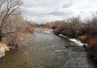
The Uncompahgre River is a tributary of the Gunnison River, approximately 75 mi (121 km) long, in southwestern Colorado in the United States. Lake Como at 12,215 ft (3723m) in northern San Juan County, in the Uncompahgre National Forest in the northwestern San Juan Mountains is the headwaters of the river. It flows northwest past Ouray, Ridgway, Montrose, and Olathe and joins the Gunnison at Confluence Park in Delta.
Uncompahgre National Forest is a U.S. National Forest covering 955,229 acres in parts of Montrose, Mesa, San Miguel, Ouray, Gunnison, Hinsdale, San Juan, and Delta Counties in western Colorado. Its headquarters are in Delta County, in the city of Delta. It borders the San Juan National Forest to the south.
Blue Mesa Reservoir is an artificial reservoir located on the upper reaches of the Gunnison River in Gunnison County, Colorado. The largest lake located entirely within the state, Blue Mesa Reservoir was created by the construction of Blue Mesa Dam, a 390 feet (120 m) tall earthen fill dam constructed on the Gunnison by the U.S. Bureau of Reclamation in 1966 for the generation of hydroelectric power. Managed as part of the Curecanti National Recreation Area, a unit of the National Park Service, Blue Mesa Reservoir is the largest lake trout and Kokanee salmon fishery in Colorado.
The Gunnison Tunnel is an irrigation tunnel constructed between 1905 and 1909 by the U.S. Bureau of Reclamation in Montrose County, Colorado. The 5.8-mile-long (9.3 km) tunnel diverts water from the Gunnison River to the arid Uncompahgre Valley around Montrose, Colorado.
The Uncompahgre Valley is an agricultural valley of the Uncompahgre River around the town of Montrose in the western part of the U.S. state of Colorado. The valley is bounded to the south and east by the San Juan Mountains and to the west by the Uncompahgre Plateau. The valley contains about 135,000 acres of irrigable land, is 35 miles long, and approximately 12 miles wide.
U.S. Route 50 (US 50) is a part of the U.S. Highway System that travels from West Sacramento, California, to Ocean City, Maryland. In the U.S. state of Colorado, US 50 is a major highway crossing through the lower midsection of the state. It connects the Western Slope with the lower Front Range and the Arkansas Valley. The highway serves the areas of Pueblo and Grand Junction as well as many other smaller areas along its corridor. The long-term project to widen the highway from two lanes to a four lane expressway between Grand Junction and Montrose was completed in January 2005. Only about 25% of the remainder of highway 50 in Colorado is four lane highway.
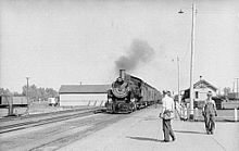
The Curecanti Needle is a 700-ft granite spire located on the Gunnison River in western Colorado. A notable landmark to generations of natives and pioneers, the Needle is located on the southern bank of Morrow Point Reservoir, an impoundment of the Gunnison river between Gunnison and Montrose, Colorado. Used for many years as an advertising symbol for the Denver and Rio Grande Western Railroad, whose narrow-gauge railway famously ran along the northern bank of the river and passed near the Needle, the spire is today part of the Curecanti National Recreation Area, a National Park Service facility that encompasses three impoundments of the Gunnison river, including Morrow Point Reservoir.
Cerro Summit is a mountain pass in the State of Colorado, located about 14 miles east of Montrose, Colorado. It divides the watershed of the Cimmaron River to the east and the Uncompahgre River to the west, both of which eventually flow into the Gunnison River.
Bustang is an intercity bus service in the U.S. state of Colorado. Service began in 2015 and originally traveled between Denver and Colorado Springs, Fort Collins, and Glenwood Springs. Service has since been expanded to connect Grand Junction, Durango, Gunnison, Alamosa, Pueblo, Fairplay and Lamar among others. It is Colorado's first state-run bus service. In 2023, the system had a ridership of 90,600, or about 1,800 per weekday as of the fourth quarter of 2023.