Mount Columbia is a mountain located in the Winston Churchill Range of the Rocky Mountains. It is the highest point in Alberta, Canada, and is second only to Mount Robson for height and topographical prominence in the Canadian Rockies. It is located on the border between Alberta and British Columbia on the northern edge of the Columbia Icefield. Its highest point, however, lies within Jasper National Park in Alberta.

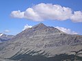
Sunwapta Peak is a peak located in the Sunwapta River valley of Jasper National Park, just north of the Columbia Icefield in Alberta, Canada. The peak was named in 1892 after the Stoney language word sunwapta meaning "turbulent river". The mountain can be seen from the Icefields Parkway.

Mount Kerkeslin is a 2,956 m (9,698 ft) mountain summit located in the Athabasca River valley of Jasper National Park, in the Canadian Rockies of Alberta, Canada. It is the highest peak of the Maligne Range. It is located in the south part of the Maligne Range, east of the Icefields Parkway and is visible from the Athabasca Falls lookout. Mount Kerkeslin is composed of sedimentary rock laid down during the Cambrian period and pushed east and over the top of younger rock during the Laramide orogeny.

Brussels Peak is a 3,161-metre (10,371 ft) mountain summit located in the Athabasca River valley of Jasper National Park, in the Canadian Rockies of Alberta, Canada. The nearest higher peak is Mount Fryatt, 6.75 km (4.19 mi) to the northwest. Brussels Peak can be seen from the Icefields Parkway.

Mount Christie is a 3,103-metre (10,180 ft) mountain summit located in the Athabasca River valley of Jasper National Park, in the Canadian Rockies of Alberta, Canada. The nearest higher peak is Brussels Peak, 1.67 km (1.04 mi) to the south-southwest. Mount Christie can be seen from the Icefields Parkway.

Dragon Peak is a 2,880 metres (9,450 ft) mountain summit located in the Athabasca River valley of Jasper National Park, in the Canadian Rockies of Alberta, Canada. Situated southeast of Mount Christie and Brussels Peak, Dragon Peak can be seen from the Icefields Parkway. The first ascent of the mountain was made in 1979 by D. Waterman. Dragon Peak was named in 1921 by Arthur O. Wheeler on account of a dragon-shaped rock formation. The mountain's name was officially adopted in 1935 by the Geographical Names Board of Canada.

Nigel Peak is a 3,211-metre (10,535-foot) mountain summit located on the shared border of Banff National Park and Jasper National Park, in the Canadian Rockies of Alberta, Canada. Nigel has two peaks, the north summit is the highest point. The nearest higher peak is Mount Athabasca, 6.4 km (4.0 mi) to the south-southwest. Nigel Peak is situated immediately north of Sunwapta Pass and can be seen from the Icefields Parkway and from Athabasca Glacier.

Tangle Ridge is a 3,000-metre (9,800 ft) mountain summit located in Jasper National Park, in the Canadian Rockies of Alberta, Canada. Tangle Ridge is situated south of Beauty Creek and north of Tangle Creek, in the Sunwapta River valley. Views from the top of Tangle Ridge provide photographers with an opportunity to capture the peaks surrounding the Columbia Icefield, some of which, such as Mount Columbia and Mount Alberta, are otherwise hidden from view along the Icefields Parkway.

Geraldine Peak is a 2,930-metre (9,610-foot) mountain summit located in the Athabasca River valley of Jasper National Park, in the Canadian Rockies of Alberta, Canada. The peak is also known as Whirlpool Mountain, and Mount Geraldine. No name has been officially adopted yet. The names derive from its position at the northern end of the long ridge that divides Geraldine Lakes and Geraldine Creek on the southeast side, from the Whirlpool River on the northwest side. The nearest higher peak is Mount Fryatt, 7.0 km (4.3 mi) to the south-southeast. Geraldine Peak can be seen from the Icefields Parkway in the vicinity of Athabasca Falls.

Mount Hardisty is a 2,716 m (8,911 ft) mountain summit located in the Athabasca River valley of Jasper National Park, in the Canadian Rockies of Alberta, Canada. Its nearest higher peak is Mount Kerkeslin, 6.0 km (3.7 mi) to the south. Both mountains are part of the Maligne Range and are visible from the Icefields Parkway.
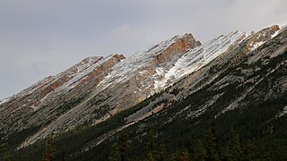
Endless Chain Ridge is a 16 kilometre long, 2,867-metre (9,406-foot) high, mountainous ridge located in Jasper National Park, in the Canadian Rockies of Alberta, Canada. The ridge is situated at the southern end of the Maligne Range, and east of the confluence of the Sunwapta River with the Athabasca River. Seen from the Icefields Parkway, the ridge is relatively unimpressive, but from the east side it appears as a rugged chain of peaks, all quite difficult to climb.

Karpathos Peak, also previously known as Mount Olympus, is a 2,987 metres (9,800 ft) mountain summit located in the Athabasca River valley of Jasper National Park, in the Canadian Rockies of Alberta, Canada. It is situated at the head of Fryatt Creek Valley on the same high ridge as Mount Christie, Brussels Peak, Mount Lowell, and Xerxes Peak. The nearest higher peak is Mount Belanger, 3.0 km (1.9 mi) to the north, and Kleodora Peak lies to the immediate northwest. Karpathos Peak can be seen from the Icefields Parkway, weather permitting.
Mount Tekarra is a 2,694 metres mountain summit located in the Athabasca River valley of Jasper National Park, in the Canadian Rockies of Alberta, Canada. It is situated at the northwest end of the Maligne Range and is visible from Jasper and the Icefields Parkway. Its nearest higher neighbor is The Watchtower, 7.0 km (4.3 mi) to the east.

Mount Lowell is a 3,150-metre (10,330 ft) mountain summit located in the Athabasca River valley of Jasper National Park, in the Canadian Rockies of Alberta, Canada. The name has not been officially adopted yet for this peak. It is situated at the head of Fryatt Creek Valley on the same high ridge as Mount Christie, Xerxes Peak, and Brussels Peak which is the nearest higher peak, 2.0 km (1.2 mi) to the north. Mount Lowell can be seen from the Icefields Parkway.

Kleodora Peak is a 2,850 metres (9,350 ft) mountain summit located in the Athabasca River valley of Jasper National Park, in the Canadian Rockies of Alberta, Canada. It is situated at the head of Fryatt Creek Valley on the same high ridge as Mount Christie, Brussels Peak, Mount Lowell, Xerxes Peak, and Karpathos Peak. Its nearest higher peak is Parnassus Peak, 1.0 km (0.62 mi) to the north. The mountain was named for Kleodora, who in Greek mythology lived on Mount Parnassus. The name has not been officially adopted yet for this peak. An unnamed glacier lies below the eastern slope in the cirque between Kleodora Peak and Mount Belanger.

Mount Warren is a 3,362-metre (11,030-foot) mountain summit located at the southeast end of Maligne Lake in Jasper National Park, in the Canadian Rockies of Alberta, Canada. Mount Warren is often seen in the background of iconic calendar photos of Spirit Island and Maligne Lake. The mountain rises 1,690 metres (5,540 ft) in less than 4 kilometres (2.5 mi) from the lake giving it dramatic local relief. Mount Warren is situated at the northwest edge of the Brazeau Icefield, and its nearest higher peak is Mount Brazeau, 2.26 kilometres to the southeast. Monkhead is a lower secondary summit to the northwest of the true summit.

Hilda Peak is a 3,058-metre (10,033-foot) mountain summit located at the northern extreme of Banff National Park, in the Canadian Rockies of Alberta, Canada. The nearest higher peak is Mount Athabasca, 2.0 km (1.2 mi) to the southwest. Hilda Peak is situated south of Sunwapta Pass and can be prominently seen from the Icefields Parkway. The Hilda Glacier lies to the south side of the peak, and the Boundary Glacier lies to the west.

Parker Ridge is a 2,255-metre (7,398-foot) mountain ridge located in the upper North Saskatchewan River valley in Banff National Park, in the Canadian Rockies of Alberta, Canada. Its nearest higher peak is Mount Athabasca, 7.7 km (4.8 mi) to the west. Parker Ridge is situated along the west side of the Icefields Parkway and southeast of Sunwapta Pass. Parker Ridge is a ski-touring destination in the winter and popular hiking destination in the summer because it is situated beside the Icefields Parkway allowing easy access, and is nearly entirely above treeline allowing good views of the surrounding mountain landscape. A 2.2 km (1.4 mi) trail gains 275 metres (900 ft) of elevation from the highway to the top of the ridge. Wandering east or west along the ridge provides views of Cirrus Mountain, the north face of Mount Saskatchewan, Saskatchewan Glacier, Mount Athabasca, Hilda Peak, and Nigel Peak among others.

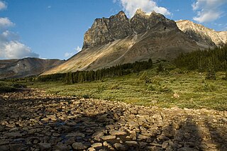
Mount Erebus is a 3,112-metre (10,210-foot) mountain summit located near one of the most beautiful mountain meccas in the world, the Tonquin Valley of Jasper National Park in Alberta, Canada. Mount Erebus is composed of sedimentary rock laid down during the Cambrian period, then was pushed east and over the top of younger rock during the Laramide orogeny. Its nearest higher peak is Mount Fraser, 4.0 km (2.5 mi) to the northwest. The Continental Divide lies 3 km (1.9 mi) to the west, Angle Peak is situated 4.5 km (2.8 mi) to the southeast, and The Ramparts are 5.0 km (3.1 mi) to the north. The mountain's north ridge terminates at Outpost Peak.

Indian Ridge is a 2,820-metre (9,252 ft) mountain located in Jasper National Park, in the Trident Range of the Canadian Rockies of Alberta, Canada. The summit is unofficially called Indian Peak. The town of Jasper is situated 9 kilometres (5.6 mi) to the north-northeast, and The Whistlers lies 2.55 kilometres (1.58 mi) to the northeast. Its nearest higher peak is Manx Peak, 4.3 km (2.7 mi) to the southwest, and Terminal Mountain lies 3.25 km (2.02 mi) to the south. The Marmot Basin alpine ski area is located 4 kilometres (2.5 mi) to the southeast. The peak is composed of sedimentary rock laid down from the Precambrian to the Jurassic periods and pushed east and over the top of younger rock during the Laramide orogeny.