
The North Atlantic Current (NAC), also known as North Atlantic Drift and North Atlantic Sea Movement, is a powerful warm western boundary current within the Atlantic Ocean that extends the Gulf Stream northeastward. [1]
The North Atlantic Current (NAC), also known as North Atlantic Drift and North Atlantic Sea Movement, is a powerful warm western boundary current within the Atlantic Ocean that extends the Gulf Stream northeastward. [1]
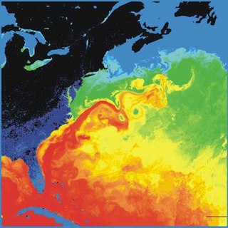
The NAC originates from where the Gulf Stream turns north at the Southeast Newfoundland Rise, a submarine ridge that stretches southeast from the Grand Banks of Newfoundland. The NAC flows northward east of the Grand Banks, from 40°N to 51°N, before turning sharply east to cross the Atlantic. It transports more warm tropical water to northern latitudes than any other boundary current; more than 40 Sv (40 million m3/s; 1.4 billion cu ft/s) in the south and 20 Sv (20 million m3/s; 710 million cu ft/s) as it crosses the Mid-Atlantic Ridge. It reaches speeds of 2 knots (3.7 km/h; 2.3 mph; 1.0 m/s) near the North American coast. Directed by topography, the NAC meanders heavily, but in contrast to the meanders of the Gulf Stream, the NAC meanders remain stable without breaking off into eddies. [1]
The colder parts of the Gulf Stream turn northward near the "tail" of the Grand Banks at 50°W where the Azores Current branches off to flow south of the Azores. From there the NAC flows northeastward, east of the Flemish Cap (47°N, 45°W). Approaching the Mid-Atlantic Ridge, it then turns eastward and becomes much broader and more diffuse. It then splits into a colder northeastern branch and a warmer eastern branch. As the warmer branch turns southward, most of the subtropical component of the Gulf Stream is diverted southward, and as a consequence, the North Atlantic is mostly supplied by subpolar waters, including a contribution from the Labrador Current recirculated into the NAC at 45°N. [2]
West of Continental Europe, it splits into two major branches. One branch goes southeast, becoming the Canary Current as it passes northwest Africa and turns southwest. The other major branch continues north along the coast of Northwestern Europe. Other branches include the Irminger Current and the Norwegian Current. Driven by the global thermohaline circulation, the North Atlantic Current is part of the wind-driven Gulf Stream, which goes further east and north from the North American coast across the Atlantic and into the Arctic Ocean.
The North Atlantic Current, together with the Gulf Stream, have a long-lived reputation for having a considerable warming influence on European climate. However, the principal cause for differences in winter climate between North America and Europe seems to be winds rather than ocean currents (although the currents do exert influence at very high latitudes by preventing the formation of sea ice). [3]
Unlike the AMOC, the observations of Labrador Sea outflow showed no negative trend from 1997 to 2009, [4] and the Labrador Sea convection began to intensify in 2012, reaching a new high in 2016. [5] As of 2022, the trend of strengthened Labrador Sea convection appears to hold, and is associated with observed increases in marine primary production. [6] Yet, a 150-year dataset suggests that even this recently strengthened convection is anomalously weak compared to its baseline state. [7]
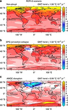
Some climate models indicate that the deep convection in Labrador-Irminger Seas could collapse under certain global warming scenarios, which would then collapse the entire circulation in the North subpolar gyre. It is considered unlikely to recover even if the temperature is returned to a lower level, making it an example of a climate tipping point. This would result in rapid cooling, with implications for economic sectors, agriculture industry, water resources and energy management in Western Europe and the East Coast of the United States. [8] Frajka-Williams et al. 2017 pointed out that recent changes in cooling of the subpolar gyre, warm temperatures in the subtropics and cool anomalies over the tropics, increased the spatial distribution of meridional gradient in sea surface temperatures, which is not captured by the AMO Index. [9]
A 2021 study found that this collapse occurs in only four CMIP6 models out of 35 analyzed. However, only 11 models out of 35 can simulate North Atlantic Current with a high degree of accuracy, and this includes all four models which simulate collapse of the subpolar gyre. As the result, the study estimated the risk of an abrupt cooling event over Europe caused by the collapse of the current at 36.4%, which is lower than the 45.5% chance estimated by the previous generation of models [10] In 2022, a paper suggested that previous disruption of subpolar gyre was connected to the Little Ice Age. [11]
A 2022 Science Magazine review study on climate tipping points noted that in the scenarios where this convection collapses, it is most likely to be triggered by 1.8 degrees of global warming. However, model differences mean that the required warming may be as low as 1.1 degrees or as high as 3.8 degrees. Once triggered, the collapse of the current would most likely take 10 years from start to end, with a range between 5 and 50 years. The loss of this convection is estimated to lower the global temperature by up to 0.5 degrees, while the average temperature in certain regions of the North Atlantic decreases by around 3 degrees. There are also substantial impacts on regional precipitation. [12] [13]

The Atlantic Ocean is the second-largest of the world's five oceans, with an area of about 85,133,000 km2 (32,870,000 sq mi). It covers approximately 17% of Earth's surface and about 24% of its water surface area. It is known to separate the "Old World" of Africa, Europe, and Asia from the "New World" of the Americas in the European perception.

North Atlantic Deep Water (NADW) is a deep water mass formed in the North Atlantic Ocean. Thermohaline circulation of the world's oceans involves the flow of warm surface waters from the southern hemisphere into the North Atlantic. Water flowing northward becomes modified through evaporation and mixing with other water masses, leading to increased salinity. When this water reaches the North Atlantic it cools and sinks through convection, due to its decreased temperature and increased salinity resulting in increased density. NADW is the outflow of this thick deep layer, which can be detected by its high salinity, high oxygen content, nutrient minima, high 14C/12C, and chlorofluorocarbons (CFCs).

Downwelling is the downward movement of a fluid parcel and its properties within a larger fluid. It is closely related to upwelling, the upward movement of fluid.
The North Atlantic Oscillation (NAO) is a weather phenomenon over the North Atlantic Ocean of fluctuations in the difference of atmospheric pressure at sea level (SLP) between the Icelandic Low and the Azores High. Through fluctuations in the strength of the Icelandic Low and the Azores High, it controls the strength and direction of westerly winds and location of storm tracks across the North Atlantic.

An ocean current is a continuous, directed movement of seawater generated by a number of forces acting upon the water, including wind, the Coriolis effect, breaking waves, cabbeling, and temperature and salinity differences. Depth contours, shoreline configurations, and interactions with other currents influence a current's direction and strength. Ocean currents are primarily horizontal water movements.

Thermohaline circulation (THC) is a part of the large-scale ocean circulation that is driven by global density gradients created by surface heat and freshwater fluxes. The adjective thermohaline derives from thermo- referring to temperature and -haline referring to salt content, factors which together determine the density of sea water. Wind-driven surface currents travel polewards from the equatorial Atlantic Ocean, cooling en route, and eventually sinking at high latitudes. This dense water then flows into the ocean basins. While the bulk of it upwells in the Southern Ocean, the oldest waters upwell in the North Pacific. Extensive mixing therefore takes place between the ocean basins, reducing differences between them and making the Earth's oceans a global system. The water in these circuits transport both energy and mass around the globe. As such, the state of the circulation has a large impact on the climate of the Earth.

In oceanography, a gyre is any large system of circulating ocean surface currents, particularly those involved with large wind movements. Gyres are caused by the Coriolis effect; planetary vorticity, horizontal friction and vertical friction determine the circulatory patterns from the wind stress curl (torque).

Sea surface temperature (SST), or ocean surface temperature, is the ocean temperature close to the surface. The exact meaning of surface varies in the literature and in practice. It is usually between 1 millimetre (0.04 in) and 20 metres (70 ft) below the sea surface. Sea surface temperatures greatly modify air masses in the Earth's atmosphere within a short distance of the shore. Local areas of heavy snow can form in bands downwind of warm water bodies within an otherwise cold air mass. Warm sea surface temperatures can develop and strengthen cyclones over the Ocean. Experts call this process tropical cyclogenesis. Tropical cyclones can also cause a cool wake. This is due to turbulent mixing of the upper 30 metres (100 ft) of the ocean. Sea surface temperature changes during the day. This is like the air above it, but to a lesser degree. There is less variation in sea surface temperature on breezy days than on calm days. Ocean currents, such as the Atlantic Multidecadal Oscillation, can affect sea surface temperatures over several decades. Thermohaline circulation has a major impact on average sea surface temperature throughout most of the world's oceans.

The Pacific decadal oscillation (PDO) is a robust, recurring pattern of ocean-atmosphere climate variability centered over the mid-latitude Pacific basin. The PDO is detected as warm or cool surface waters in the Pacific Ocean, north of 20°N. Over the past century, the amplitude of this climate pattern has varied irregularly at interannual-to-interdecadal time scales. There is evidence of reversals in the prevailing polarity of the oscillation occurring around 1925, 1947, and 1977; the last two reversals corresponded with dramatic shifts in salmon production regimes in the North Pacific Ocean. This climate pattern also affects coastal sea and continental surface air temperatures from Alaska to California.

The Labrador Current is a cold current in the North Atlantic Ocean which flows from the Arctic Ocean south along the coast of Labrador and passes around Newfoundland, continuing south along the east coast of Canada near Nova Scotia. Near Nova Scotia, this cold water current meets the warm northward moving Gulf Stream. The combination of these two currents produces heavy fogs and has also created one of the richest fishing grounds in the world.

The Atlantic meridional overturning circulation (AMOC) is part of a global thermohaline circulation in the oceans and is the zonally integrated component of surface and deep currents in the Atlantic Ocean. It is characterized by a northward flow of warm, salty water in the upper layers of the Atlantic, and a southward flow of colder, deep waters. These "limbs" are linked by regions of overturning in the Nordic and Labrador Seas and the Southern Ocean, although the extent of overturning in the Labrador Sea is disputed. The AMOC is an important component of the Earth's climate system, and is a result of both atmospheric and thermohaline drivers.
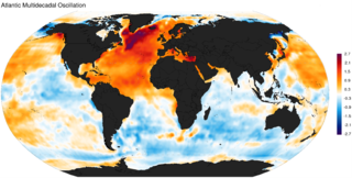
The Atlantic Multidecadal Oscillation (AMO), also known as Atlantic Multidecadal Variability (AMV), is the theorized variability of the sea surface temperature (SST) of the North Atlantic Ocean on the timescale of several decades.
In climate science, a tipping point is a critical threshold that, when crossed, leads to large, accelerating and often irreversible changes in the climate system. If tipping points are crossed, they are likely to have severe impacts on human society and may accelerate global warming.
The Gulf Stream, together with its northern extension the North Atlantic Drift, is a warm and swift Atlantic ocean current that originates in the Gulf of Mexico and flows through the Straits of Florida and up the eastern coastline of the United States, then veers east near 36°N latitude and moves toward Northwest Europe as the North Atlantic Current. The process of western intensification causes the Gulf Stream to be a northward-accelerating current off the east coast of North America. Around 40°0′N30°0′W, it splits in two, with the northern stream, the North Atlantic Drift, crossing to Northern Europe and the southern stream, the Canary Current, recirculating off West Africa.
The Great Salinity Anomaly (GSA) originally referred to an event in the late 1960s to early 1970s where a large influx of freshwater from the Arctic Ocean led to a salinity anomaly in the northern North Atlantic Ocean, which affected the Atlantic meridional overturning circulation. Since then, the term "Great Salinity Anomaly" has been applied to successive occurrences of the same phenomenon, including the Great Salinity Anomaly of the 1980s and the Great Salinity Anomaly of the 1990s. The Great Salinity Anomalies were advective events, propagating to different sea basins and areas of the North Atlantic, and is on the decadal-scale for the anomalies in the 1970s, 1980s, and 1990s.
Cold core rings are a type of oceanic eddy, which are characterized as unstable, time-dependent swirling, independent ‘cells’ that separate from their respective ocean current and move into water bodies with different physical, chemical, and biological characteristics, often bringing the physical, chemical, and biological characteristics of the waters of their origin into the water bodies into which they travel. Their size can range from 1 millimeter (0.039 in) to over 10,000 kilometers (6,200 mi) in diameter with depths over 5 kilometers (3.1 mi). Cold core rings are the product of warm water currents wrapping around a colder water mass as it deviates away from its respective current. The direction an eddy swirls can be categorized as either cyclonic or anticyclonic, which is, in the Northern Hemisphere, counterclockwise and clockwise respectively, and in the Southern Hemisphere, clockwise and counterclockwise respectively as a result of the Coriolis effect. Although eddies have large amounts of kinetic energy, their rotation is relatively quick to decrease in relation to the amount of viscous friction in water. They typically last for a few weeks to a year. The nature of eddies are such that the center of the eddy, the outer swirling ring, and the surrounding waters are well stratified and maintain all of their distinctive physical, chemical, and biological properties throughout the eddy’s lifetime, before losing their distinctive characteristics at the end of the life of the cold core ring.
Labrador Sea Water is an intermediate water mass characterized by cold water, relatively low salinity compared to other intermediate water masses, and high concentrations of both oxygen and anthropogenic tracers. It is formed by convective processes in the Labrador Sea located between Greenland and the northeast coast of the Labrador Peninsula. Deep convection in the Labrador Sea allows colder water to sink forming this water mass, which is a contributor to the upper layer of North Atlantic Deep Water. North Atlantic Deep Water flowing southward is integral to the Atlantic Meridional Overturning Circulation. The Labrador Sea experiences a net heat loss to the atmosphere annually.
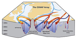
The Overturning in the Subpolar North Atlantic Program (OSNAP) is an international project designed to study the mechanistic link between water mass transformation at high latitudes and the meridional overturning circulation in the North Atlantic (AMOC) on interannual time scales. Though this linkage is evident in climate models on decadal time scales, to date there has been no clear demonstration of AMOC variability in response to changes in deep water formation on interannual and decadal time scales. OSNAP intends to fill that gap by providing a continuous record of the trans-basin fluxes of heat, mass and freshwater for a comparison to records of convective activity and water mass transformation at high latitudes in the North Atlantic.
Open ocean convection is a process in which the mesoscale ocean circulation and large, strong winds mix layers of water at different depths. Fresher water lying over the saltier or warmer over the colder leads to the stratification of water, or its separation into layers. Strong winds cause evaporation, so the ocean surface cools, weakening the stratification. As a result, the surface waters are overturned and sink while the "warmer" waters rise to the surface, starting the process of convection. This process has a crucial role in the formation of both bottom and intermediate water and in the large-scale thermohaline circulation, which largely determines global climate. It is also an important phenomena that controls the intensity of the Atlantic Meridional Overturning Circulation (AMOC).
Delia Wanda Oppo is an American scientist who works on paleoceanography where she focuses on past variations in water circulation and the subsequent impact on Earth's climate system. She was elected a fellow of the American Geophysical Union in 2014.
Ocean currents and gyres | |||||||||||
|---|---|---|---|---|---|---|---|---|---|---|---|
| Currents |
| ||||||||||
| Gyres |
| ||||||||||
| Related | |||||||||||