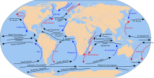
Ocean current in the Pacific, Atlantic, and Indian Ocean
South Equatorial Current (in black)
The South Equatorial Current are ocean currents in the Pacific, Atlantic, and Indian Ocean that flow east-to-west between the equator and about 20 degrees south. In the Pacific and Atlantic Oceans, it extends across the equator to about 5 degrees north.
Within the southern hemisphere, the South Equatorial Current is the westward limb of the very large-scale subtropical gyres. These gyres are driven by the combination of trade winds in the tropics and westerly winds that are found south of about 30 degrees south, through a rather complicated process that includes western boundary current intensification.
On the equator, the South Equatorial Current is driven directly by the trade winds which blow from east to west.
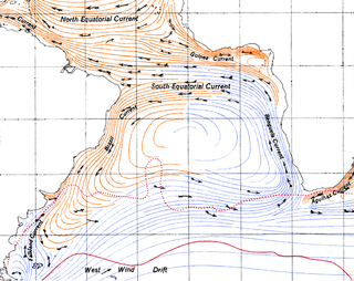
In the Indian Ocean, the westward-flowing South Equatorial Current is well-developed only south of the equator. Directly on the equator, the winds reverse twice a year due to the monsoons, and so the surface current can be either eastward or westward.
Upwelling is an oceanographic phenomenon that involves wind-driven motion of dense, cooler, and usually nutrient-rich water from deep water towards the ocean surface. It replaces the warmer and usually nutrient-depleted surface water. The nutrient-rich upwelled water stimulates the growth and reproduction of primary producers such as phytoplankton. The biomass of phytoplankton and the presence of cool water in those regions allow upwelling zones to be identified by cool sea surface temperatures (SST) and high concentrations of chlorophyll a.
An ocean current is a continuous, directed movement of seawater generated by a number of forces acting upon the water, including wind, the Coriolis effect, breaking waves, cabbeling, and temperature and salinity differences. Depth contours, shoreline configurations, and interactions with other currents influence a current's direction and strength. Ocean currents are primarily horizontal water movements.
Physical oceanography is the study of physical conditions and physical processes within the ocean, especially the motions and physical properties of ocean waters.
The Intertropical Convergence Zone, known by sailors as the doldrums or the calms because of its monotonous windless weather, is the area where the northeast and the southeast trade winds converge. It encircles Earth near the thermal equator though its specific position varies seasonally. When it lies near the geographic Equator, it is called the near-equatorial trough. Where the ITCZ is drawn into and merges with a monsoonal circulation, it is sometimes referred to as a monsoon trough, a usage that is more common in Australia and parts of Asia.
Atmospheric circulation is the large-scale movement of air and together with ocean circulation is the means by which thermal energy is redistributed on the surface of the Earth. The Earth's atmospheric circulation varies from year to year, but the large-scale structure of its circulation remains fairly constant. The smaller-scale weather systems – mid-latitude depressions, or tropical convective cells – occur chaotically, and long-range weather predictions of those cannot be made beyond ten days in practice, or a month in theory.
The Cromwell Current is an eastward-flowing subsurface current that extends the length of the equator in the Pacific Ocean.
The Benguela Current is the broad, northward flowing ocean current that forms the eastern portion of the South Atlantic Ocean gyre. The current extends from roughly Cape Point in the south, to the position of the Angola-Benguela front in the north, at around 16°S. The current is driven by the prevailing south easterly trade winds. Inshore of the Benguela Current proper, the south easterly winds drive coastal upwelling, forming the Benguela Upwelling System. The cold, nutrient rich waters that upwell from around 200–300 m (656–984 ft) depth in turn fuel high rates of phytoplankton growth, and sustain the productive Benguela ecosystem.
In oceanography, a gyre is any large system of circulating ocean currents, particularly those involved with large wind movements. Gyres are caused by the Coriolis effect; planetary vorticity, horizontal friction and vertical friction determine the circulatory patterns from the wind stress curl (torque).
The North Atlantic Gyre of the Atlantic Ocean is one of five great oceanic gyres. It is a circular ocean current, with offshoot eddies and sub-gyres, across the North Atlantic from the Intertropical Convergence Zone to the part south of Iceland, and from the east coasts of North America to the west coasts of Europe and Africa.
The North Equatorial Current (NEC) is a westward wind-driven current mostly located near the equator, but the location varies from different oceans. The NEC in the Pacific and the Atlantic is about 5°-20°N, while the NEC in the Indian Ocean is very close to the equator. It ranges from the sea surface down to 400 m in the western Pacific.
The Equatorial Counter Current is an eastward flowing, wind-driven current which extends to depths of 100–150 metres (330–490 ft) in the Atlantic, Indian, and Pacific Oceans. More often called the North Equatorial Countercurrent (NECC), this current flows west-to-east at about 3-10°N in the Atlantic, Indian Ocean and Pacific basins, between the North Equatorial Current (NEC) and the South Equatorial Current (SEC). The NECC is not to be confused with the Equatorial Undercurrent (EUC) that flows eastward along the equator at depths around 200 metres (660 ft) in the western Pacific rising to 100 metres (330 ft) in the eastern Pacific.
The North Pacific Gyre (NPG) or North Pacific Subtropical Gyre (NPSG), located in the northern Pacific Ocean, is one of the five major oceanic gyres. This gyre covers most of the northern Pacific Ocean. It is the largest ecosystem on Earth, located between the equator and 50° N latitude, and comprising 20 million square kilometers. The gyre has a clockwise circular pattern and is formed by four prevailing ocean currents: the North Pacific Current to the north, the California Current to the east, the North Equatorial Current to the south, and the Kuroshio Current to the west. It is the site of an unusually intense collection of human-created marine debris, known as the Great Pacific Garbage Patch.
The Madagascar current is an oceanic current in the west Indian Ocean.
The Tasman Outflow is a water pathway connecting water from the Pacific Ocean and the Indian Ocean. The existence of the outflow was published by scientists of the Australian CSIRO's Division of Marine and Atmospheric Research team in August 2007, interpreting salinity and temperature data captured from 1950 to 2002. The Tasman Outflow is seen as the missing link in the supergyre of the Southern Hemisphere and an important part of the thermohaline circulation.
In physical oceanography and fluid dynamics, the wind stress is the shear stress exerted by the wind on the surface of large bodies of water – such as oceans, seas, estuaries and lakes. Stress is the quantity that describes the magnitude of a force that is causing a deformation of an object. Therefore, stress is defined as the force per unit area and its SI unit is the Pascal. When the deforming force acts parallel to the object's surface, this force is called a shear force and the stress it causes is called a shear stress. When wind is blowing over a water surface, the wind applies a wind force on the water surface. The wind stress is the component of this wind force that is parallel to the surface per unit area. Also, the wind stress can be described as the flux of horizontal momentum applied by the wind on the water surface. The wind stress causes a deformation of the water body whereby wind waves are generated. Also, the wind stress drives ocean currents and is therefore an important driver of the large-scale ocean circulation. The wind stress is affected by the wind speed, the shape of the wind waves and the atmospheric stratification. It is one of the components of the air–sea interaction, with others being the atmospheric pressure on the water surface, as well as the exchange of energy and mass between the water and the atmosphere.
Boundary currents are ocean currents with dynamics determined by the presence of a coastline, and fall into two distinct categories: western boundary currents and eastern boundary currents.
The Indian Monsoon Current refers to the seasonally varying ocean current regime found in the tropical regions of the northern Indian Ocean. During winter, the flow of the upper ocean is directed westward from near the Indonesian Archipelago to the Arabian Sea. During the summer, the direction reverses, with eastward flow extending from Somalia into the Bay of Bengal. These variations are due to changes in the wind stress associated with the Indian monsoon. The seasonally reversing open ocean currents that pass south of India are referred to as the Winter Monsoon Current and the Summer Monsoon Current. The Somali Current, which is strongly linked to the Indian monsoon, is also discussed in this article.
The Indian Ocean gyre, located in the Indian Ocean, is one of the five major oceanic gyres, large systems of rotating ocean currents, which together form the backbone of the global conveyor belt. The Indian Ocean gyre is composed of two major currents: the South Equatorial Current, and the West Australian Current.
The Barrier layer in the ocean is a layer of water separating the well-mixed surface layer from the thermocline.
A Wind generated current is a flow in a body of water that is generated by wind friction on its surface. Wind can generate surface currents on water bodies of any size. The depth and strength of the current depend on the wind strength and duration, and on friction and viscosity losses, but are limited to about 400 m depth by the mechanism, and to lesser depths where the water is shallower. The direction of flow is influenced by the Coriolis effect, and is offset to the right of the wind direction in the Northern Hemisphere, and to the left in the Southern Hemisphere. A wind current can induce secondary water flow in the form of upwelling and downwelling, geostrophic flow, and western boundary currents.
This page is based on this Wikipedia article Text is available under the CC BY-SA 4.0 license; additional terms may apply. Images, videos and audio are available under their respective licenses.