North Kesteven

Last updated

North Kesteven District
District
Eastgate St - Sleaford - geograph.org.uk - 2131230.jpg
College Hall, Cranwell Avenue, RAF Cranwell - geograph.org.uk - 3607373.jpg
Hangar 5 at RAF Waddington - geograph.org.uk - 4061277.jpg
Village Cross, High Street, Washingborough - geograph.org.uk - 4808719.jpg
The Forum - Christmas Day 2015 - geograph.org.uk - 4773318.jpg
North Kesteven UK locator map.svg
Shown within the ceremonial county of Lincolnshire
Sovereign state United Kingdom
Constituent country England
Region East Midlands
Administrative county Lincolnshire
Admin. HQ Sleaford
Government
  TypeNorth Kesteven District Council
   Leadership:Leader & Cabinet
   MPs: Caroline Johnson
Karl McCartney
Area
  Total356.2 sq mi (922.5 km2)
  Rank 30th
Population
 (2021)
  Total118,553
  Rank Ranked 200th
  Density330/sq mi (130/km2)
Ethnicity (2021)
[1]
   Ethnic groups
List
Religion (2021)
[1]
   Religion
List
Time zone UTC+0 (Greenwich Mean Time)
  Summer (DST) UTC+1 (British Summer Time)
ONS code 32UE (ONS)
E07000139 (GSS)
Ethnicity98.9% White

North Kesteven is a local government district in Lincolnshire, England. The council is based in Sleaford. The district also contains the town of North Hykeham, which adjoins the neighbouring city of Lincoln, along with numerous villages and surrounding rural areas.

Contents

The neighbouring districts are Lincoln, West Lindsey, East Lindsey, Boston, South Holland, South Kesteven and Newark and Sherwood.

History

The district was formed on 1 April 1974 under the Local Government Act 1972. It covered the area of three former districts from the administrative county of Kesteven, which were all abolished at the same time: [2]

The new district was named North Kesteven referencing its position within Kesteven, one of the three historic parts of Lincolnshire. [3]

Governance

North Kesteven District Council
North Kesteven District Council logo.svg
Type
Type
Leadership
Mike Clarke,
Conservative
since 23 May 2023
Richard Wright,
Conservative
since 30 March 2017
Ian Fytche
Structure
Seats43 councillors
Political groups
Administration (24)
  Conservatives (24)
Other parties (19)
  Lincolnshire Ind. (10)
  Independent (6)
  Labour (2)
  Liberal Democrat (1)
Elections
Last election
4 May 2023
Last election
6 May 2027
Meeting place
Sleaford - North Kesteven council offices.jpg
Council Offices, Kesteven Street, Sleaford, NG34 7EF
Website
www.n-kesteven.gov.uk

North Kesteven District Council provides district-level services. County-level services are provided by Lincolnshire County Council. [4] The whole district is also covered by civil parishes, which form a third tier of local government. [5]

Political control

The council has been under Conservative majority control since the 2023 election. [6]

The first election to the council was held in 1973, initially operating as a shadow authority alongside the outgoing authorities until the new arrangements came into effect on 1 April 1974. Political control of the council since 1974 has been as follows: [7]

Party in controlYears
Independent 1974–1987
No overall control 1987–2007
Conservative 2007–2019
No overall control 2019–2023
Conservative 2023–present

Leadership

The leaders of the council since 2001 have been: [8]

CouncillorPartyFromTo
Marion Brighton Conservative 20019 Mar 2017
Richard Wright Conservative 30 Mar 2017

Composition

Following the 2023 election and a change of allegiance and by-election in December 2023 the composition of the council was: [9] [10]

PartyCouncillors
Conservative 24
Lincolnshire Independent 10
Independent 6
Labour 2
Liberal Democrats 1
Total43

Four of the independent councillors sit together as the "Group of Unaligned Members", and the other two do not belong to any group. [11] The next election is due in 2027.

Premises

The council is based at the North Kesteven Council Offices at the corner of Kesteven Street and East Gate in Sleaford. The building had been built in 1856 as a row of houses called Lafford Terrace. [12] [13] It was purchased in 1925 by Kesteven County Council and converted to become its headquarters.

When local government was reorganised in 1974, it was originally planned to have North Kesteven's offices in Bracebridge Hall on Newark Road in Lincoln, then the base of North Kesteven Rural District Council. In November 1973, a decision was taken to base it in The Hoplands in Sleaford, the base of East Kesteven Rural District Council. In January 1974 it was realised that this building was too small for the size needed, and the 81 rooms of Kesteven County Council's headquarters in Sleaford would suit the new council instead. The Hoplands was subsequently demolished for housing.

Elections

Since the last boundary changes in 2023 the council has comprised 43 councillors representing 24 wards, with each ward electing one, two or three councillors. Elections are held every four years. [14]

Geography

The Forum shopping area, North Hykeham The Forum, North Hykeham, Lincolnshire, England - DSCF1457.JPG
The Forum shopping area, North Hykeham

North Kesteven borders West Lindsey (along the Foss Dyke and the River Witham) and the city of Lincoln to the north, East Lindsey to the north-east (along the River Witham), Boston (borough) to the east, South Holland to the south-east, South Kesteven to the south, and the county of Nottinghamshire to the west.

RAF Waddington is a main employer in the district F15 and AWACS Operations at RAF Waddington.jpg
RAF Waddington is a main employer in the district

North Kesteven covers an area of 356 square miles (920 km2), of which 94% is classified as green space, which includes agricultural land and open space. [15]

St Wilfred's Church, Metheringham St Wilfred's Church, Metheringham - geograph.org.uk - 2514531.jpg
St Wilfred's Church, Metheringham

The district is characterised by small settlements and large areas of arable farmland. More than 80% of the population live in rural settlements or a market town. [16] The two towns are Sleaford and North Hykeham, and the larger villages include Cranwell, Metheringham, Navenby, Ruskington and Waddington.

The district has two main RAF stations - RAF Cranwell (near Sleaford), and RAF Waddington (near Lincoln), both situated close to the A15, the main north–south road running through North Kesteven. The district is also home to RAF Digby, which lies between Sleaford and Metheringham. The former RAF Swinderby, which can be found adjacent to the A46 near the western edge of the district, closed in 1995.

Demography

Skyline of North Hykeham which forms part of the wider Lincoln urban area Pond at North Hykeham - geograph.org.uk - 1094664.jpg
Skyline of North Hykeham which forms part of the wider Lincoln urban area

The predominantly rural nature of the district has encouraged people to move to the area to take advantage of its quality of life, low crime rates, relatively low house prices, good-quality education and local heritage. This is reflected in research, which has shown 90% of residents are satisfied with their local area as a place to live and 82% of residents feel their area is a place where people from different backgrounds can get on well together. [17]

North Kesteven is mostly rural in character but there are urban areas around the towns of North Hykeham and Sleaford. Sleaford forms an urban area with the nearby villages of Greylees, Holdingham, Leasingham and Quarrington, North Hykeham and Waddington form part of an urban area with the city of Lincoln. [18] Within the district, 40% of the population live in the "Lincoln Fringe", the area immediately surrounding Lincoln City. [19] 72 parishes serve the district communities, comprising 58 parish councils, two town councils and 12 parish meetings.

The population of the district was 107,766 at the 2011 census. [20]

Education

College Hall, RAF Cranwell near Cranwell College Hall, RAF Cranwell - geograph.org.uk - 2663405.jpg
College Hall, RAF Cranwell near Cranwell

The district has comprehensive schools in North Hykeham, Branston and Welbourn. The area around Sleaford (including Ruskington) has selective schools. Other schools in the area include Kesteven and Sleaford High School and Branston Community College.

The district part funds The National Centre for Craft & Design, in the Hub building in Sleaford. Adjacent to it are annex buildings of Grantham College, funded by the East Midlands LSC.

Media

In terms of television, East Lindsey is served by BBC Yorkshire and Lincolnshire and ITV Yorkshire broadcasting from the Belmont transmitter. [21]

Radio stations for the area are BBC Radio Lincolnshire, Lincs FM, and Greatest Hits Radio Lincolnshire. [22]

Lincolnshire Echo is the local newspaper. [23]

Towns and parishes

The entire district is divided into civil parishes. The parish councils for Sleaford and North Hykeham take the style "town council". Some of the smaller parishes share grouped parish councils or have parish meetings instead of parish councils. [24]

Arms

Coat of arms of North Kesteven
Crest
On a wreath Argent and Vert out of the battlements of a tower a crane wings expanded and inverted proper supporting with the interior foot a Maltese cross resting upon the battlements quarterly Gules and Argent.
Escutcheon
Per chevron Vert and Sable on a chevron Or between in chief two bars wavy the nether issuant Argent surmounted of a demi eagle issuant displayed wings inverted Or and in base an oak tree issuant fructed Or three estoiles Sable.
Motto
Rectam Viam Sequi (To Follow The Right Road) [25]

Related Research Articles

<span class="mw-page-title-main">Sleaford</span> Market town and civil parish in Lincolnshire, England

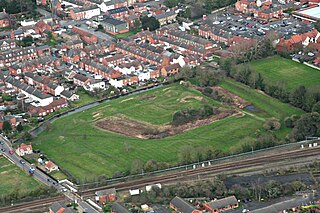
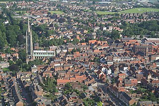
Sleaford is a market town and civil parish in the North Kesteven district of Lincolnshire, England. Centred on the former parish of New Sleaford, the modern boundaries and urban area include Quarrington to the south-west, Holdingham to the north and Old Sleaford to the east. The town is on the edge of the fertile Fenlands, 11 miles north-east of Grantham, 16 mi (26 km) west of Boston, and 17 mi (27 km) south of Lincoln. Its population of 17,671 at the 2011 Census made it the largest settlement in the North Kesteven district; it is the district's administrative centre. Bypassed by the A17 and the A15, it is linked to Lincoln, Newark, Peterborough, Grantham and King's Lynn.

<span class="mw-page-title-main">Kesteven</span> Traditional division of Lincolnshire, England

The Parts of Kesteven are a traditional division of Lincolnshire, England. This division had long had a separate county administration, along with the two other Parts of Lincolnshire, Lindsey and Holland.

<span class="mw-page-title-main">East Lindsey</span> Non-metropolitan district in England

East Lindsey is a local government district in Lincolnshire, England. Its council is based in Horncastle and the largest town is Skegness. Other towns include Alford, Burgh le Marsh, Coningsby, Louth, Mablethorpe, Spilsby, Sutton on Sea, Wainfleet All Saints, Wragby and Woodhall Spa. The district also covers a large rural area, including many smaller settlements.

<span class="mw-page-title-main">West Lindsey</span> District in England

West Lindsey is a local government district in Lincolnshire, England. Its council is based in Gainsborough, the district's largest town. The district also includes the towns of Caistor and Market Rasen, along with numerous villages and surrounding rural areas. The east of the district includes part of the Lincolnshire Wolds, a designated Area of Outstanding Natural Beauty.

<span class="mw-page-title-main">South Kesteven</span> Local government district in Lincolnshire, England

South Kesteven is a local government district in Lincolnshire, England, forming part of the traditional Kesteven division of the county. Its council is based in Grantham. The district also includes the towns of Bourne, Market Deeping and Stamford, along with numerous villages and surrounding rural areas.

<span class="mw-page-title-main">Sleaford and North Hykeham (UK Parliament constituency)</span> Parliamentary constituency in the United Kingdom, 1997 onwards

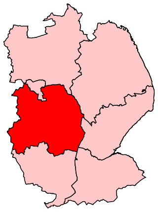
Sleaford and North Hykeham is a parliamentary constituency in Lincolnshire, England which elects a single Member of Parliament (MP) to the House of Commons of the UK Parliament. It has been represented since 2016 by Dr Caroline Johnson, who is a member of the Conservative Party. The seat was created in 1997 and has always been represented by Members of Parliament (MPs) from the Conservative Party; like all British constituencies, it elects one candidate by the first-past-the-post voting system. Johnson became the MP for the constituency after a by-election in December 2016, following the resignation of the previous MP for the seat, Stephen Phillips. The constituency is considered a safe seat for the Conservatives.

<span class="mw-page-title-main">Ruskington</span> Village in Lincolnshire, England

Ruskington is a village and civil parish in the North Kesteven district of Lincolnshire, England, located approximately 4 miles (6.4 km) north of Sleaford on the north–south B1188 road and slightly north of the A153 road. The village contains approximately 2,200 dwellings and is approximately 1 mile (1.6 km) in length, measured from east to west. The population of the civil parish was 5,169 at the 2001 census, increasing to 5,637 at the 2011 census.

Ashby de la Launde and Bloxholm is a civil parish in the North Kesteven district of Lincolnshire, England. According to the 2001 Census it had a population of 796, increasing to 837 at the 2011 census. The parish includes the villages of Ashby de la Launde and Bloxholm, and the southern part of Scopwick Heath. For administrative reasons the parish council is also responsible for the adjacent parish of Temple Bruer with Temple High Grange.

<span class="mw-page-title-main">North Hykeham</span> Town in North Kesteven, Lincolnshire, England

North Hykeham is a town and civil parish in the North Kesteven district, in the county of Lincolnshire, England. It forms part of the Lincoln Urban Area. The population of the town at the 2011 census was 13,884.

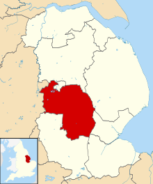
North Kesteven District Council in Lincolnshire, England is elected every four years.

<span class="mw-page-title-main">Great Hale</span> Village and civil parish in the North Kesteven district of Lincolnshire, England

Great Hale is a village and civil parish in the North Kesteven district of Lincolnshire, England. The population of the civil parish at the 2011 census was 778. It is situated on the B1394 road, immediately south from Heckington and 1.7 miles (2.7 km) north from Helpringham.

<span class="mw-page-title-main">Navenby</span> Village and civil parish in Lincolnshire, England

Navenby is a village and civil parish in the North Kesteven district of Lincolnshire, England. Lying 8 miles (13 km) south from Lincoln and 9 miles (14 km) north-northwest from Sleaford, Navenby had a population of 2,128 in the 2011 census and in March 2011, it was named as the 'Best Value Village' in England following a national survey.

<span class="mw-page-title-main">Robert Pattinson (politician)</span> British Liberal politician and businessman

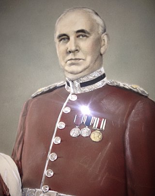
Sir Robert Pattinson, JP, DL was a British Liberal politician and businessman. Pattinson joined his family's railway contracting firm after finishing school and was quickly appointed to senior positions. In 1900, he became chairman of Ruskington Urban District Council and four years later joined Kesteven County Council, eventually becoming an alderman and serving as its chairman for 20 years between 1934 and his death in 1954. He chaired the Sleaford Liberal Association (1900–18) and was nominated as the party's representative for Sleaford shortly before World War I broke out. He contested Grantham unsuccessfully in 1918, but was returned for the seat in 1922, serving until he was defeated in the following year's general election. Several other unsuccessful attempts at a parliamentary career followed. He chaired several bodies responsible for maintaining Lincolnshire's waterways, served as a magistrate for Kesteven and Lindsey and sat as Lincolnshire's High Sheriff in 1941. Knighted in 1934, Pattinson died aged 82 in 1954 after several years of illness.

<span class="mw-page-title-main">Quarrington, Lincolnshire</span> Village in England

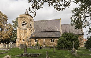
Quarrington is a village and former civil parish, now part of the civil parish of Sleaford, in the North Kesteven district of Lincolnshire, England. The old village and its church lie approximately 1 miles (2 km) south-west from the centre of Sleaford. Suburban housing developments at New Quarrington and Quarrington Hill effectively link the two settlements. Bypassed by the A15, it is connected to Lincoln and Peterborough, as well as Newark and King's Lynn. At the 2011 census, Quarrington and Mareham ward, which incorporates most of the settlement, had an estimated population of 7,046.

<span class="mw-page-title-main">Holdingham</span> Hamlet in Lincolnshire, England

Holdingham is a hamlet in the civil parish and built-up area of Sleaford, Lincolnshire. It is bisected by Lincoln Road (B1518) which joins the A17 and A15 roads immediately north of the settlement; those roads connect it to Lincoln, Newark, Peterborough and King's Lynn. Sleaford railway station is on the Nottingham to Skegness and Peterborough to Lincoln Lines.

<span class="mw-page-title-main">Branston and Mere</span>

Branston and Mere is a civil parish in the North Kesteven district of Lincolnshire, England, about 4 miles (6 km) roughly south-east of Lincoln. The parish is a long strip between the RAF Waddington airfield and the River Witham near Bardney. The A15 road crosses the extreme west and the parish is bisected by the Sleaford to Lincoln railway line The civil parish was created in 1931, by merging the two former parishes of Branston and Mere.

The Lafford High School, Billinghay was a secondary-level, co-educational Community School in Billinghay, a village in the English county of Lincolnshire. Opened in 1963 to serve several villages near Billinghay, it serving pupils aged 11 to 16 before closing in 2010. The school used a secondary modern admissions system and had a capacity for 365 pupils at the time of its closure.

<span class="mw-page-title-main">Central Lincolnshire</span>

Central Lincolnshire is the name given to a region of Lincolnshire in the East Midlands, England. The area covers the districts of North Kesteven and West Lindsey as well as the City of Lincoln. The name is used for the planning and development of a part of Lincolnshire surrounding Lincoln, North Hykeham, Sleaford, Market Rasen, Caistor and Gainsborough as well as other outlying villages and hamlets.

References

  1. 1 2 UK Census (2021). "2021 Census Area Profile – North Kesteven Local Authority (E07000139)". Nomis. Office for National Statistics . Retrieved 5 January 2024.
  2. "The English Non-metropolitan Districts (Definition) Order 1972", legislation.gov.uk , The National Archives, SI 1972/2039, retrieved 29 June 2023
  3. "The English Non-metropolitan Districts (Names) Order 1973", legislation.gov.uk , The National Archives, SI 1973/551, retrieved 29 June 2023
  4. "Local Government Act 1972", legislation.gov.uk , The National Archives, 1972 c. 70, retrieved 31 May 2023
  5. "Election maps". Ordnance Survey. Retrieved 6 June 2023.
  6. Karran, Ellis (5 May 2023). "Conservatives increase control of North Kesteven despite Labour win". The Lincolnite. Retrieved 29 June 2023.
  7. "Compositions calculator". The Elections Centre. 4 March 2016. Retrieved 1 June 2023.
  8. "Council minutes". North Kesteven District Council. Retrieved 10 August 2022.
  9. "Local elections 2023: live council results for England". The Guardian.
  10. Jaines, Daniel (15 December 2023). "Lib Dems snatch seat from Conservatives in North Kesteven by-election". The Lincolnite. Retrieved 15 December 2023.
  11. "Political structure". North Kesteven District Council. Retrieved 29 June 2023.
  12. Historic England. "Lafford Terrace, Eastgate (1062147)". National Heritage List for England . Retrieved 30 August 2022.
  13. "Sleaford, Lafford Terrace". Society for Lincolnshire History and Archaeology. Retrieved 30 August 2022.
  14. "The North Kesteven (Electoral Changes) Order 2021", legislation.gov.uk , The National Archives, SI 2021/1052, retrieved 29 June 2023
  15. Communities and Local Government (1 January 2005). "Land Use Statistics (Generalised Land Use Database)" . Retrieved 1 January 2009.
  16. DEFRA (2005). "Defra Classification of Local Authority Districts and Unitary Authorities in England: An Introductory Guide" (PDF). Archived from the original (PDF) on 3 October 2007. Retrieved 3 March 2009.
  17. Ipsos Mori (2009). Place Survey 2008 North Kesteven: Provisional Weighted National Indicator Results (Report).
  18. NKDC (2008). NK Facts and Figures: Parish Estimates based on Council Tax Households (Report).
  19. Office for National Statistics (2001). "The Census 2001" . Retrieved 4 January 2009.
  20. "North Kesteven Local Authority". NOMIS. Office for National Statistics. Retrieved 10 August 2022.
  21. "Belmont (Lincolnshire, England) Full Freeview transmitter". UK Free TV. 1 May 2004. Retrieved 25 April 2024.
  22. "Radio Lincolnshire – Find Your Local Station". Lincolnshire.org. Retrieved 25 April 2024.
  23. "Lincolnshire Echo". British Papers. 17 September 2013. Retrieved 25 April 2024.
  24. "Parish council contact details". North Kesteven District Council. Retrieved 29 June 2023.
  25. "East Midlands Region". Civic Heraldry of England. Retrieved 8 March 2021.

53°09′N0°30′W / 53.15°N 0.50°W / 53.15; -0.50