
The Dual Contracts, also known as the Dual Subway System, were contracts for the construction and/or rehabilitation and operation of rapid transit lines in the City of New York. The contracts were signed on March 19, 1913, by the Interborough Rapid Transit Company and the Brooklyn Rapid Transit Company. As part of the Dual Contracts, the IRT and BRT would build or upgrade several subway lines in New York City, then operate them for 49 years.
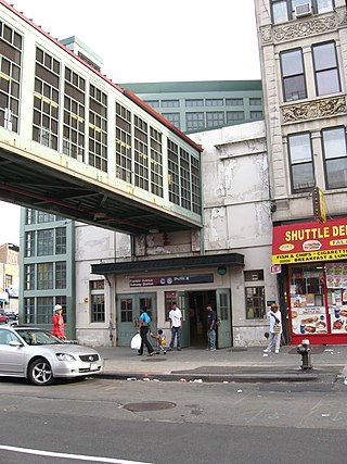
The Franklin Avenue station is a station complex shared by the BMT Franklin Avenue Line and the IND Fulton Street Line of the New York City Subway, located at Franklin Avenue and Fulton Street in Bedford–Stuyvesant, Brooklyn. It is served by the:
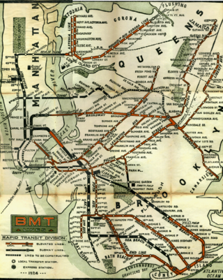
The BMT Jamaica Line, also known as the Broadway - Brooklyn Line, is an elevated rapid transit line of the B Division of the New York City Subway, in Brooklyn and Queens, New York City, United States. It runs from the Williamsburg Bridge southeast over Broadway to East New York, Brooklyn, and then east over Fulton Street and Jamaica Avenue to Jamaica, Queens. In western Jamaica, the line goes into a tunnel, becoming the lower level of the Archer Avenue lines in central Jamaica. The J and Z trains serve the entire length of the Jamaica Line, and the M serves the line west of Myrtle Avenue.
The BMT Lexington Avenue Line was the first standard elevated railway in Brooklyn, New York, operated in its later days by the Brooklyn Rapid Transit Company, the Brooklyn–Manhattan Transit Corporation, and then the City of New York.
The Myrtle Avenue Line, also called the Myrtle Avenue Elevated, is a fully elevated line of the New York City Subway as part of the BMT division. The line is the last surviving remnant of one of the original Brooklyn elevated railroads. The remnant line operates as a spur branch from the Jamaica Line to Bushwick, Ridgewood, and Middle Village, terminating at its original eastern terminal across the street from Lutheran Cemetery. Until 1969, the line continued west into Downtown Brooklyn and, until 1944, over the Brooklyn Bridge to the Park Row Terminal in Manhattan.
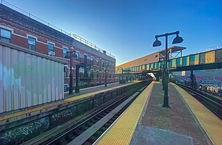
The Myrtle Avenue station is a New York City Subway express station on the BMT Jamaica Line. Located at the intersection of Myrtle Avenue and Broadway in Bushwick, Brooklyn. It is served by the J and M trains at all times, and by the Z during rush hours in peak direction.

The Myrtle–Wyckoff Avenues station is a New York City Subway station complex formed by the intersecting stations of the BMT Canarsie Line and the BMT Myrtle Avenue Line, served by the L and M trains at all times. It is located at Myrtle Avenue and Wyckoff Avenue in the Bushwick neighborhood of Brooklyn and the Ridgewood neighborhood of Queens. The complex is connected by a set of stairs and several elevators and escalators between the elevated and underground levels. The station was renovated completely from 2004 to 2008.

The Gates Avenue station is a local station on the elevated BMT Jamaica Line of the New York City Subway, located at the intersection of Gates Avenue and Broadway at the border of Bedford–Stuyvesant and Bushwick, Brooklyn. It is served by the Z train during rush hours in the peak direction and by the J train at all other times.

The Kosciuszko Street station is a local station on the BMT Jamaica Line of the New York City Subway. It is served by the J train at all times. The Z train skips this station when it operates.

The Central Avenue station is a station on the BMT Myrtle Avenue Line of the New York City Subway. Located at Myrtle Avenue and Cedar Street in Bushwick, Brooklyn, it is served by the M train at all times.

The Marcy Avenue station is a station on the BMT Jamaica Line of the New York City Subway. Located at the intersection of Marcy Avenue and Broadway in Brooklyn, it is served by the J train at all times, the M train at all times except late nights, and the Z train during rush hours in the peak direction.
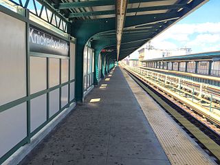
The Knickerbocker Avenue station is a station on the BMT Myrtle Avenue Line of the New York City Subway. Located at the intersection of Myrtle and Knickerbocker Avenues in Bushwick, Brooklyn, it is served by the M train at all times.

The Broadway Junction station is a New York City Subway station complex shared by the elevated BMT Canarsie Line and BMT Jamaica Line, and the underground IND Fulton Street Line. It was also served by trains of the Fulton Street Elevated until that line closed in 1956. It is located roughly at the intersection of Broadway, Fulton Street and Van Sinderen Avenue at the border of Bedford–Stuyvesant and East New York, Brooklyn. The complex is served by the A, J, and L trains at all times; the C train at all times except late nights; and the Z train during rush hours in the peak direction only.

The Fulton Street Line, also called the Fulton Street Elevated or Kings County Line, was an elevated rail line mostly in Brooklyn, New York City, United States. It ran above Fulton Street from Fulton Ferry, Brooklyn, in Downtown Brooklyn east to East New York, and then south on Van Sinderen Avenue (southbound) and Snediker Avenue (northbound), east on Pitkin Avenue, north on Euclid Avenue, and east on Liberty Avenue to Ozone Park, Queens.
The Bridge-Jay Street station was a station on the demolished BMT Myrtle Avenue Line in Brooklyn, New York City. It had 2 tracks and 1 island platform. It was opened on April 10, 1888 as Jay Street, and served Myrtle Avenue Line trains as well as the BMT Lexington Avenue Line, and until it was demolished in 1940, the BMT Fifth Avenue Line, which itself also served BMT Culver Line trains. From 1944 until its demolition in 1969, it had a free transfer to the IND Fulton Street and IND Culver lines at Jay Street – Borough Hall. Around that time, it was renamed "Bridge-Jay Street." The next stop to the north was Navy Street for trains traveling on the Lexington & Myrtle Avenue Lines, and Fulton Street other trains until its demolition in 1940. The next stop to the south was Adams Street. The station was closed on October 4, 1969, after a fire on the elevated structure.
The Franklin Avenue station was a station on the demolished section of the BMT Myrtle Avenue Line. The station was located at the intersection of Myrtle and Franklin Avenues in Bedford-Stuyvesant, Brooklyn, New York, United States. The station opened in 1889, and closed in 1969.
The Tompkins Avenue station was a station on the demolished section of the BMT Myrtle Avenue Line. The station was located at the intersection of Myrtle and Tompkins Avenues in Bedford-Stuyvesant, Brooklyn. The station opened in 1889, and closed in 1969.
The Sumner Avenue station was a station on the demolished section of the BMT Myrtle Avenue Line. The station was located at the intersection of Myrtle Avenue and Sumner Avenues in Bedford-Stuyvesant, Brooklyn. The station opened in 1889, and closed in 1969.
The Grand Avenue station was a station on the demolished section of the BMT Myrtle Avenue Line in Brooklyn, New York City. The station was opened on April 27, 1889, at the intersection of Myrtle Avenue and Grand Avenue in Brooklyn next to the Myrtle Avenue station of the BMT Lexington Avenue Line, which opened four years earlier. It had two tracks and two side platforms, and had connections not only to that station, but also to Myrtle Avenue Line streetcars. The next southbound stop was Washington Avenue. The next northbound stop was Franklin Avenue. The connection to the Lexington Avenue el station lasted until that station closed on October 13, 1950. Grand Avenue closed on January 21, 1953, while the rest of the line southwest of Broadway was operational until October 4, 1969.


