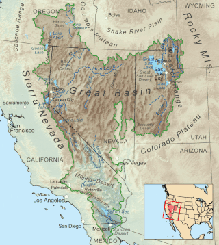
The Great Basin is the largest area of contiguous endorheic watersheds, those with no outlets, in North America. It spans nearly all of Nevada, much of Utah, and portions of California, Idaho, Oregon, Wyoming, and Baja California. It is noted for both its arid climate and the basin and range topography that varies from the North American low point at Badwater Basin in Death Valley to the highest point of the contiguous United States, less than 100 miles (160 km) away at the summit of Mount Whitney. The region spans several physiographic divisions, biomes, ecoregions, and deserts.

The Basin and Range Province is a vast physiographic region covering much of the inland Western United States and northwestern Mexico. It is defined by unique basin and range topography, characterized by abrupt changes in elevation, alternating between narrow faulted mountain chains and flat arid valleys or basins. The physiography of the province is the result of tectonic extension that began around 17 million years ago in the early Miocene epoch.

The Boston Mountains is a Level III ecoregion designated by the Environmental Protection Agency (EPA) in the U.S. states of Arkansas and Oklahoma. Part of the Ozarks, the Boston Mountains are a deeply dissected plateau. The ecoregion is steeper than the adjacent Springfield Plateau to the north, and bordered on the south by the Arkansas Valley. The Oklahoma portion of the range is locally referred to as the Cookson Hills. There are several theories of how the mountains were named, though apparently none are related to the Massachusetts city.
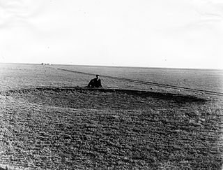
The High Plains are a subregion of the Great Plains, mainly in the Western United States, but also partly in the Midwest states of Nebraska, Kansas, and South Dakota, generally encompassing the western part of the Great Plains before the region reaches the Rocky Mountains. The High Plains are located in eastern Montana, southeastern Wyoming, southwestern South Dakota, western Nebraska, eastern Colorado, western Kansas, eastern New Mexico, the Oklahoma Panhandle, and the Texas Panhandle. The southern region of the Western High Plains ecology region contains the geological formation known as Llano Estacado which can be seen from a short distance or on satellite maps. From east to west, the High Plains rise in elevation from around 1,800 to 7,000 ft.

The Smoky Hills are an upland region of hills in the central Great Plains of North America. They are located in the Midwestern United States, encompassing north-central Kansas and a small portion of south-central Nebraska.
Henry Gannett was an American geographer who is described as the "father of mapmaking in America." He was the chief geographer for the United States Geological Survey essentially from its founding until 1902.

The American Association of Geographers (AAG) is a non-profit scientific and educational society aimed at advancing the understanding, study, and importance of geography and related fields. Its headquarters is located in Washington, D.C. The organization was founded on December 29, 1904, in Philadelphia, as the Association of American Geographers, with the American Society of Professional Geographers later amalgamating into it in December 1948 in Madison, Wisconsin. As of 2020, the association has more than 10,000 members, from nearly 100 countries. AAG members are geographers and related professionals who work in the public, private, and academic sectors.

John James Stevenson was an American geologist, born in New York City. He graduated from New York University in 1863, became professor of chemistry at West Virginia University for two years (1869–71), then served as professor of geology at New York University until 1909. During 1873–74 and from 1878 to 1880 he was geologist for the United States Geological Survey. He also served on the Pennsylvania Geological Survey from 1875 to 1878 and from 1881 to 1882. He was president of the Geological Society of America in 1898.

The U.S. state of Georgia is commonly divided into four geologic regions that influence the location of the state's four traditional physiographic regions. The four geologic regions include the Appalachian foreland, Blue Ridge, Piedmont, and Coastal Plain. These four geologic regions commonly share names with and typically overlap the four physiographic regions of the state: the Appalachian Plateau and adjacent Valley and Ridge; the Blue Ridge; the Piedmont and the Coastal Plain.

Erwin Raisz was a Hungarian-born American cartographer, best known for his physiographic maps of landforms.
Dans Mountain is located in Allegany County, Maryland, USA between Georges Creek and the North Branch Potomac River. The highest point on Dans Mountain is called Dan's Rock which has an elevation of 2,895 feet (882 m). The mountain rises 2,200 feet (670 m) above the town of LaVale and the summit is the highest point in Allegany County. Although there are higher points in Maryland, Dans Mountain has the most impressive escarpment of Maryland's mountains. It is essentially continuous with the longer escarpment that continues both north and south known as the Allegheny Front.
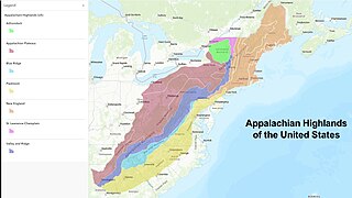
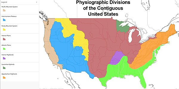
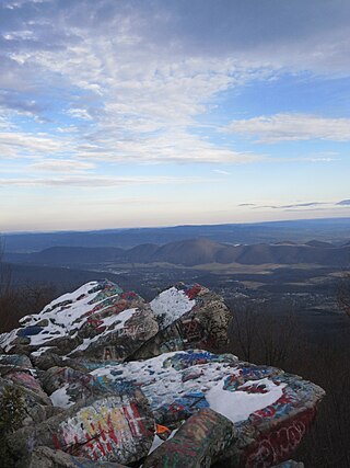
The Appalachian Highlands is one of eight government-defined physiographic divisions of the contiguous (conterminous) United States. The land area is linked together with the Appalachian Uplands of Canada to make up the Appalachian Mountains. Therefore, from a geographic standpoint, the term Appalachian Highlands is not a synonym for the term Appalachian Mountains. The Highlands includes seven physiographic provinces, which is the second level in the physiographic classification system in the United States. At the next level of physiographic classification, called section/subsection, there are 20 unique land areas,.
Physiographic regions are a means of defining Earth's landforms into distinct, mutually exclusive areas, independent of political boundaries. It is based upon the classic three-tiered approach by Nevin M. Fenneman in 1916, that separates landforms into physiographic divisions, physiographic provinces, and physiographic sections. The classification mechanism has become a popular geographical tool in the United States, indicated by the publication of a USGS shapefile that maps the regions of the original work and the National Park Services's use of the terminology to describe the regions in which its parks are located. Originally used in North America, the model became the basis for similar classifications of other continents.

The New England province is a physiographic province of the larger Appalachian Highlands division of the United States. The province consists of the Seaboard Lowland, New England Upland, White Mountain, Green Mountain, and Taconic sections.
Armin Kohl Lobeck (1886-1958) was a noted American Cartographer, Geomorphologist and Landscape Artist. He was born in New York City on August 16, 1886, but his family moved to Haworth, New Jersey, three years later.

The Portage Escarpment is a major landform in the U.S. states of Ohio, Pennsylvania, and New York which marks the boundary between the Till Plains to the north and west and the Appalachian Plateau to the east and south. The escarpment is the defining geological feature of New York's Finger Lakes region. Its proximity to Lake Erie creates a narrow but easily traveled route between upstate New York and the Midwest. Extensive industrial and residential development occurred along this route.
Lawrence Martin was an American geographer and president of the American Association of Geographers.

The Cascade-Sierra province is a physiographic region of mountains in the western United States, east and adjacent to Pacific Border province and west and adjacent to the Basin and Range Province and Columbia Plateau Province.
Nevin Melancthon Fenneman was an American professor of geology, with a long career at the University of Cincinnati. His contributions were primarily in the large scale geographical understanding of American geology and based on his wide ranging studies, he produced a classification of US physiographic regions using a three-tiered system of 8 major divisions, 25 provinces and 78 sections that remains in use today.