Point Breeze, Philadelphia

Last updated
Point Breeze
Landreth School Philly.JPG
Street map of Philadelphia and surrounding area.png
Red pog.svg
Point Breeze
Coordinates: 39°56′05″N75°10′53″W / 39.93482°N 75.18146°W / 39.93482; -75.18146
CountryFlag of the United States.svg  United States
State Pennsylvania
County Philadelphia
City Philadelphia
ZIP Code
19145, 19146
Area code(s) 215, 267 and 445

Point Breeze is a multicultural neighborhood in South Philadelphia in Philadelphia, Pennsylvania, United States. It is bounded by 25th Street to the west, Washington Avenue to the north, 18th Street to the east, and Moore Street to the south. Southwest Center City lies to its north. Passyunk Square and East Passyunk Crossing lie to its east. Point Breeze is separated from Grays Ferry to the west by a CSX railway viaduct over 25th Street.

Contents

History

According to historical maps, much of what is South Philadelphia, including Point Breeze, was still not yet developed and integrated into the rectilinear grid system by 1843 or later. [1] [ original research? ] "Point Breeze" was a point on the western side of the Schuylkill River, approximately where the Passyunk Avenue bridge is today.

In the 1860s it and the area across on the eastern side of the river were developed as an area for oil refinery by the Atlantic Petroleum Company, later the Atlantic Richfield Company (ARCO). Oil that had been extracted in Western Pennsylvania could be processed here and then shipped down the Schuylkill, to the Delaware and out to sea. [2] The Avenue that connected the city proper to the east side of the river at Point Breeze was known in 1808 as "Long Lane." [1]

In the mid-to-late 1800s, development of Philadelphia continued westward from the Delaware River and southward from Market Street. Long Lane also began to be known as Point Breeze Avenue by 1895 [1] and lent its name to the neighborhood that was to spring up here. "The earliest references to Point Breeze" as a neighborhood "date to 1895." [3] The area was first settled by working-class European Jewish immigrants, followed by Italian and Irish immigrants. In 1930s numerous African Americans settled here, some of whom had come North in the Great Migration, escaping Jim Crow in the South and looking for work in industrial cities. At this time the African-American center of Philadelphia was shifting from near Mother Bethel African Methodist Episcopal Church at 6th and Lombard, to west of Broad. [4]

Washington Avenue and 19th Street, looking into Point Breeze WashingtonAvenuePhilly.jpg
Washington Avenue and 19th Street, looking into Point Breeze

Through the 1960s Point Breeze was reported to be a safe, clean, relatively integrated, and self-sufficient neighborhood, with a thriving business district along Point Breeze Avenue. Residents called it "The Breeze." Rising racial tensions, fear of race riots and white flight in the 1960s and 1970s resulted in many businesses moving away, and the neighborhood becoming majority African American. Also at this time, people who could afford it often moved to newer suburban housing, aided by greater ease in commuting by public transit and highways.

The heroin epidemic of the 1970s, and crack epidemic of the '90s and related crime adversely affected Point Breeze. Between 1988 and 1990 the Philadelphia Police department conducted raids in Point Breeze to shut down the Carr family drug ring; it reportedly had been selling $1.3 million per year in crack, cocaine and prescription drugs. [5] [6] [7]

The Point Breeze Performing Arts Center opened in 1984 on Point Breeze Avenue. [8] From 1990 through 2000 Point Breeze lost approximately 10% of its population. [9] Despite this, since the 1990s some revitalization efforts have taken place; such organizations as South Philadelphia H.O.M.E.S. and Universal Companies, owned by Kenny Gamble, have helped build low-income housing and schools in the area.

Immigrants from Southeast Asia have moved into Point Breeze in the 1990s and 2000s. For example, in the 2000 census Point Breeze contained the highest concentration of Vietnamese in the city; the more than 900 Vietnamese people comprised nearly 12% of the population of Point Breeze. [10]

In the 2000s and beyond, Point Breeze has had some revitalization through gentrification. Real estate investors such as John Longacre and Ori Feibush have begun developing property here, especially along the Broad Street and Washington Avenue corridors. [11] [12] While many residents resent the changing neighborhoods and feel displaced in areas they once called home, others believe such change signals a booming resurgence in the area, which has both trendy bars and lower crime. In 2016 the YouTube channel "New Neighbors" interviewed longtime Point Breeze residents about the gentrification efforts. One man said existing residents were harassed by increased police scrutiny; a woman said that her brother was killed here long ago. She noted the lack of shopping for regular goods.

She said,

"We have everything in Point Breeze that's no good for any human consumption, it [Point Breeze] does not nurture any entrepreneur spirit or anything else - other then people that are foreigners, that come in and get money to open up businesses in the community. Who do not necessarily give back when you ask...but I think it's a great thing in terms of the changes in the community, I welcome it with open arms." [13]

In July 2019 the Philadelphia Inquirer published an op-ed titled "Gentrification displaced my family from Point Breeze", written by Angelita Ellison, Philadelphia City Clerk. [14] She described the hardship of being displaced from her neighborhood of 16 years, and after leaving, seeing the renovation of a long unused and unfunded neighborhood tennis court.

As a response to recent gentrification in the area, a community land trust sponsored by WCRP was created to cover at least five homes in the area with 99-year transferable leases. [15] Overall public reaction to gentrification remains mixed. While some residents are not bothered and outreach organizations are helping those in need, some residents have vandalized new properties, spraying anarchy symbols and other messages such as "(expletive) the rich. [16]

A number of historic buildings in the area, including the George W. Childs School, David Landreth School, Marine Corps Supply Activity, Delaplaine McDaniel School, Jeremiah Nichols School, Walter George Smith School, and the former Francis M. Drexel School are listed on the National Register of Historic Places. [17]

Name origin

'Point Breeze' was originally the name given to a spot on the west side of the Schuylkill River. Point Breeze Avenue then became the road that cut southwest to provide access to the spot from what was at the time Philadelphia proper. The avenue cuts diagonally through the neighborhood's rectilinear street grid.

Culture

Keith Haring's mural ''We the Youth'' at 22nd and Ellsworth Streets in Point Breeze. Keith Haring We Are The Youth.jpg
Keith Haring's mural ''We the Youth'' at 22nd and Ellsworth Streets in Point Breeze.

Point Breeze is home to several Philadelphia Mural Arts Program murals. In 1987 Keith Haring collaborated with CityKids, a New York-based youth organization, to create a mural titled We the Youth located at 22nd and Ellsworth in Point Breeze. In 2013 the Mural Arts program restored the mural and a small community garden was built beneath it. [18] [19]

Education

Residents are zoned to the School District of Philadelphia. [20] There are 4 catchment areas in Point Breeze. Delaplaine McDaniel School K–8 (named after the Quaker merchant) at 22nd and Moore serves the westernmost catchment, Edwin M. Stanton School K-8 (named after the Secretary of War under Lincoln) at 17th and Christian serves the northernmost catchment and George W. Childs School K–8 (named after the publisher) at 16th and Wharton serves the easternmost catchment. All of the students in these three catchment areas are eligible to attend South Philadelphia High School. (Norris S. Barratt middle school was formerly the name of the school at 16th and Wharton but it closed in 2011 due to declining enrollment. [21] The former George W. Childs elementary school built in 1894 at 17th and Tasker was placed on the National Register of Historic Places in 1988 but was shuttered in 2010 and its fate remains uncertain. [22] [23] ) The southernmost catchment of Point Breeze attends Stephen Girard School K–4 (named after the wealthy banker) at 18th and Snyder, Universal Institute Charter School at Vare 5–8 at 24th and Snyder and Universal Institute Charter School at Audenried 9-12 at 33rd and Tasker. [24]

Infrastructure and government

Point Breeze Avenue northern terminus. Federal Street running west is in the foreground. 20th Street is on the left, Point Breeze Avenue on the right. Philadelphia Fire Department Engine Company 24 visible at the corner with the Philadelphia Police Department 17th District office on the far left. Point Breeze Avenue northern terminus.JPG
Point Breeze Avenue northern terminus. Federal Street running west is in the foreground. 20th Street is on the left, Point Breeze Avenue on the right. Philadelphia Fire Department Engine Company 24 visible at the corner with the Philadelphia Police Department 17th District office on the far left.

The United States Postal Service operates the Point Breeze Post Office at 2500 Snyder Avenue. [25]

Engine 24 The Federal Express protecting the Breeze since 1872.

The Philadelphia Police Department's 17th District station is at the northern terminus of Point Breeze Avenue where it intersects 20th and Federal. [26]

The Free Library of Philadelphia operates two branches in Point Breeze: the South Philadelphia Branch at Broad and Morris and the Queen Memorial Library at 23rd and Federal (located in the Landreth Apartments for seniors). [27] On May 9, 2016 the $45.2 million, 96,000-square foot, LEED-certified South Philadelphia Community Health and Literacy Center officially opened at Broad and Morris Streets in Point Breeze. It houses the new South Philadelphia library branch, a CHOP pediatric primary care center, a Philadelphia Department of Public Health community health center, and a new DiSilvestro Playground and Recreation Center. [28] [29] [2]

Point Breeze has several indoor and outdoor recreational areas: [30]

Transportation

Point Breeze is served by the SEPTA Broad Street Line, accessible at Snyder, Tasker-Morris, and Ellsworth-Federal stations, and several SEPTA bus routes run through the neighborhood.

Notable people

See also

Related Research Articles

<span class="mw-page-title-main">South Philadelphia</span> Neighborhood of Philadelphia, Pennsylvania

South Philadelphia, nicknamed South Philly, is the section of Philadelphia bounded by South Street to the north, the Delaware River to the east and south, and the Schuylkill River to the west. A diverse working-class community of many neighborhoods, South Philadelphia is well-known for its large Italian-American population, but it also contains large Asian American, Irish-American, African-American, and Latino populations.

<span class="mw-page-title-main">West Philadelphia</span> Neighborhood of Philadelphia, Pennsylvania

West Philadelphia, nicknamed West Philly, is a section of the city of Philadelphia. Although there are no officially defined boundaries, it is generally considered to reach from the western shore of the Schuylkill River, to City Avenue to the northwest, Cobbs Creek to the southwest, and the SEPTA Media/Wawa Line to the south. An alternate definition includes all city land west of the Schuylkill; this would also include Southwest Philadelphia and its neighborhoods. The eastern side of West Philadelphia is also known as University City.

<span class="mw-page-title-main">Mantua, Philadelphia</span> Neighborhood of Philadelphia

Mantua is a neighborhood in the West Philadelphia section of Philadelphia, Pennsylvania. It is located north of Spring Garden Street, east of 40th Street, south of Mantua Avenue, and west of 31st Street. The neighborhood's northern and western reaches are predominantly working-class and African American, although its southern border with Powelton Village has seen recent gentrification and an influx of Drexel University and University of Pennsylvania student renters.

<span class="mw-page-title-main">Kensington, Philadelphia</span> Neighborhood in Philadelphia, Pennsylvania

Kensington is a neighborhood in Philadelphia that belongs to Lower Northeast. As with all neighborhoods in the city, the lack of any official designation means the boundaries of the area vary between sources over time and are disputed among locals. Kensington, as most long-term residents view it, refers generally to the area consisting of Kensington, East Kensington, West Kensington, and Harrowgate. The adjacent Fairhill and Norris Square neighborhoods are more separate but may be included in Kensington; Fishtown and South (Olde) Kensington were historically included. The most conservative boundaries of the neighborhood, shown in the map below, are Front Street and 5th Street to the west, the Amtrak train tracks to the North, Trenton Avenue, the Trenton Avenue train tracks, and Frankford Avenue to the east, and Cecil B. Moore Avenue to the south.

<span class="mw-page-title-main">Southwest Center City Philadelphia</span> Neighborhood of Philadelphia in Philadelphia, Pennsylvania

Southwest Center City (SWCC), also known as Graduate Hospital, is a neighborhood that is located in South Philadelphia, Pennsylvania, United States, bordering Center City Philadelphia. The neighborhood is bordered on the north by South Street, on the south by Washington Avenue, on the west by the Schuylkill River, and on the east by Broad Street.

<span class="mw-page-title-main">Bella Vista, Philadelphia</span> Neighborhood of Philadelphia in Pennsylvania, United States

Bella Vista, Italian for "beautiful sight", is a neighborhood in the South Philadelphia section of Philadelphia, Pennsylvania, United States.

<span class="mw-page-title-main">Grays Ferry, Philadelphia</span> Neighborhood of Philadelphia in Pennsylvania, United States

Grays Ferry, also known as Gray's Ferry, is a neighborhood in South Philadelphia, Pennsylvania, United States, bounded (roughly) by 25th Street on the east, the Schuylkill River on the west, Vare Avenue on the south, and Grays Ferry Avenue on the north. The section of this neighborhood west of 34th Street is also known as Forgotten Bottom. Grays Ferry shares borders with Southwest Center City to the North, Point Breeze to the East, and Girard Estate to the South. Gray’s Ferry is across from where Mill Creek debouches at about 43rd street. Historically, Grays Ferry was one of the largest enclaves of Irish Americans in the city, and while there are still many Irish left, it is now home to a significant African American population.

<span class="mw-page-title-main">Southwark, Philadelphia</span> Former District in Pennsylvania, United States

Southwark was originally the Southwark District, a colonial-era municipality in Philadelphia County, Pennsylvania, United States. Today, it is a neighborhood in the South Philadelphia section of Philadelphia, Pennsylvania. Because of its location south of the early Philadelphia, the name was adopted in allusion to the borough of Southwark in the county of London, England, just south of the city of London.

<span class="mw-page-title-main">Sharswood, Philadelphia</span> Neighborhood of Philadelphia in Pennsylvania, United States

Sharswood is a small neighborhood in the North Philadelphia section of the city of Philadelphia, Pennsylvania in the United States. It is located to the east of Brewerytown, north of Girard College, west of Ridge Avenue, east of 24th Street and south of Cecil B. Moore Avenue. It is often grouped with Brewerytown, as in the Brewerytown-Sharswood Community Civic Association, and the Brewerytown-Sharswood NTI Planning Area.

<span class="mw-page-title-main">Marconi Plaza</span>

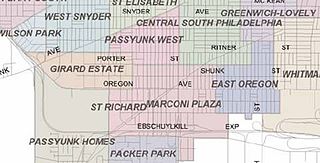
Marconi Plaza is an urban park square located in South Philadelphia, Philadelphia, Pennsylvania, United States. The plaza was named to recognize the 20th-century cultural identity in Philadelphia of the surrounding Italian-American enclave neighborhood and became the designation location of the annual Columbus Day Parade.

<span class="mw-page-title-main">Pennsport</span> Neighborhood of Philadelphia in Pennsylvania, United States

Pennsport is a neighborhood in the South Philadelphia section of Philadelphia, Pennsylvania, United States.

Newbold is a highly gentrified neighborhood located in South Philadelphia, Pennsylvania, United States.

<span class="mw-page-title-main">East Passyunk Crossing, Philadelphia</span> Neighborhood of Philadelphia in Pennsylvania, United States

East Passyunk Crossing is a neighborhood in South Philadelphia, Pennsylvania, United States. Its location is considered to be from Tasker Street to Snyder Avenue and Broad Street to 6th Street.

<span class="mw-page-title-main">Passyunk Square, Philadelphia</span> Neighborhood of Philadelphia, Pennsylvania, US

Passyunk Square is a neighborhood in South Philadelphia bounded by Broad Street to the west, 6th Street to the east, Tasker Street to the south and Washington Avenue to the north. Passyunk Square is bordered by the Bella Vista, Hawthorne, Central South Philadelphia, Wharton, and Point Breeze neighborhoods. The neighborhood got its Lenape name from the 1800s Passyunk Township, Pennsylvania which named Passyunk Square Park, located between 12th, 13th, Reed and Wharton Streets. The park was eventually renamed Columbus Square Park, and subsequently the neighborhood became known as Columbus Square. Sue Montella, Geoff DiMasi, and a group of neighbors revived the Passyunk Square name when forming the Passyunk Square Civic Association in 2003. The name "Passyunk Square" was researched and proposed by Geoff DiMasi after considering other historical names like Wharton that had been used in the neighborhood over the years. The area has come to be known as Little Saigon for its large Vietnamese American commercial and residential presence, with one of the largest Vietnamese populations on the east coast.

Wharton is a neighborhood in South Philadelphia, Pennsylvania, United States. Its boundaries are difficult to ascertain; the City of Philadelphia states it is along Wharton Street, west of Pennsport, and east of Point Breeze. According to this description, the neighborhood runs from about 4th Street to Broad, with no clear north to south boundaries. By other descriptions, the neighborhood runs from 8th to 13th Streets and Wolf to Tasker Streets. This description places Wharton along the southern border of Passyunk Square.

Gentrification is the controversial process of affluent people moving into a historically low-income neighborhood. It is often criticized because the current residents have limited options to buy or rent equivalent housing in alternative areas at the same price. If they stay, prices for products, services, and taxes rise and existing social networks are disturbed. Gentrification is the opposite of white flight—when residents voluntarily move away as a neighborhood declines.

<span class="mw-page-title-main">West Passyunk</span> Neighborhood of Philadelphia in Pennsylvania, United States

West Passyunk is a neighborhood in South Philadelphia, Pennsylvania, United States. It is bounded by Mifflin Street to the north, West Passyunk Avenue to the south, South 18th Street to east, and South 25th Street to the west. It is served by the 1st Police District, located at 24th and Wolf Streets.

The Food Trust is a nonprofit organization. It was founded in 1992 by Duane Perry in Philadelphia, Pennsylvania. The current executive director is Yael Lehmann. The goal of the organization is to improve the health of children and adults by providing better nutrition. The Food Trust works with neighborhoods, schools, grocers, farmers and policymakers to implement a comprehensive approach to improved food access that combines nutrition education and greater availability of affordable, healthy food. It is currently operating 25 farmer's markets in the Philadelphia region. The markets accept SNAP/food stamps, Farmers’ Market Nutrition Program vouchers and Philly Food Bucks. The Food Trust is funded by private foundations, government grants, and individual donors.

<span class="mw-page-title-main">Dickinson Square West</span> Neighborhood of Philadelphia in Pennsylvania, United States

Dickinson Square West is a neighborhood in South Philadelphia, Pennsylvania, United States bordered by neighborhoods Queen Village to the north, Whitman to the south, Pennsport to the east and Passyunk Square and East Passyunk Crossing to the west. The neighborhood was previously referred to as "Dickinson Narrows", but was officially reestablished as "Dickinson Square West" in 2013 by the Registered Community Organization, Dickinson Square West Civic Association, located within its boundaries. In October, 2018, The Dickinson Square West Civic Association passed an amendment to expand the southern boundary from Mifflin Street to Snyder Ave

References

  1. 1 2 3 Greater Philadelphia GeoHistory Network
  2. 1 2 "A Petaled Rose Of Hell: Refineries, Fire Risk, And The New Geography Of Oil In Philadelphia's Tidewater", "Hidden City Philadelphia"
  3. "The place where you live: Point Breeze", South Philly Review October 7, 2004
  4. "Point Breeze", "The PhillyHistory Blog: Discoveries from the City Archives," August 5, 2010
  5. "House Is Seized, Sealed As Site Of Open Drug Sales", The Philadelphia Inquirer, June 29, 1989
  6. "This Drug Operation, Police Say, Was A Family Affair", The Philadelphia Inquirer, July 9, 1989
  7. "Alleged Drug Family Raided", The Philadelphia Inquirer, March 9, 1990
  8. "Neighborhood: Point Breeze" Archived 2014-07-25 at the Wayback Machine , "Center City District + Central Philadelphia Development Corporation"
  9. 1 2 "Community Profile: Point Breeze, South Philly Review
  10. "Recent Trends in Immigration to Philadelphia, Pennsylvania: Who came and where do they live?" Archived 2016-03-04 at the Wayback Machine , Pennsylvania University Arts & Sciences Fels Institute of Government, Christopher Patusky & Johnny Ceffalio, August 2004, p. 29
  11. "American Sardine Bar's John Longacre: It's Not About Race and Class", Philadelphia Magazine, May 20, 2013
  12. "Changing Skyline: Savvy marketing, social media skills are keys for Point Breeze development". The Philadelphia Inquirer. 23 February 2013.
  13. Archived at Ghostarchive and the Wayback Machine : "New Neighbors: Point Breeze". YouTube .
  14. Ellison, Angelita (July 30, 2019). "Gentrification displaced my family from Point Breeze". Philadelphia Inquirer.
  15. "Taking on gentrification with a Point Breeze community land trust".
  16. "Graffiti in Point Breeze believed to be part of gentrification: Neighbors". 13 February 2020.
  17. "National Register Information System". National Register of Historic Places . National Park Service. July 9, 2010.
  18. "Keith Haring Mural Philadelphia Gets Makeover", "AP," October 30, 2013
  19. "'We the Youth' recreates Keith Haring's vision", South Philly Review , November 7, 2013
  20. "Philadelphia Neighborhoods and Place Names, L-P." City of Philadelphia. Retrieved on October 4, 2011. "East of Schuylkill River, north of Passyunk Avenue, south of Grays Ferry Avenue. "
  21. "Farewell to Barratt", South Philly Review , June 23, 2011
  22. "Plan Philly: Vacant School Buildings Affect Surrounding Communities", "Philadelphia Neighborhoods," December 6, 2012
  23. "Point Breeze: Plans Uncertain for Future of Former G.W. Childs Community School Building", "Philadelphia Neighborhoods," December 12, 2013
  24. "The School District of Philadelphia School Finder"
  25. "Post Office Location - POINT BREEZE." United States Postal Service . Retrieved on December 4, 2008.
  26. "Philadelphia Police Department Districts"
  27. "The Free Library Of Philadelphia Branches"
  28. "South Philly center combines health, literacy, recreation", Philly.com
  29. "CHOP opens new health center, library, rec center all in one", The Metro
  30. "City of Philadelphia Parks & Recreation"