
Hunting Park is a neighborhood in the North Philadelphia section of the United States city of Philadelphia, Pennsylvania.

Fairmount is a neighborhood within Lower North Philadelphia, Pennsylvania, United States. Its boundaries are north of Fairmount Avenue, west of Corinthian Avenue, south of Girard Avenue and east of The Schuylkill River. While this may be the most accurate demarcation, the area's boundaries fluctuate depending how the neighborhood is defined. Several other neighborhoods near Fairmount are sometimes also collectively called Fairmount, including: Spring Garden, Franklintown and Francisville. Fairmount and neighboring Spring Garden are commonly referred to as the "Art Museum Area," for their proximity to and association with the Philadelphia Museum of Art. Fairmount is also the location of the Eastern State Penitentiary.

Northern Liberties is a neighborhood in Philadelphia, Pennsylvania, United States. Prior to its incorporation into Philadelphia in 1854, it was among the top 10 largest cities in the U.S. in every census from 1790 to 1850.

South Philadelphia, nicknamed South Philly, is the section of Philadelphia bounded by South Street to the north, the Delaware River to the east and south, and the Schuylkill River to the west. A diverse working-class community of many neighborhoods, South Philadelphia is well-known for its large Italian-American population, but it also contains large Asian American, Irish-American, African-American, and Latino populations.

Point Breeze is a multicultural neighborhood in South Philadelphia in Philadelphia, Pennsylvania, United States. It is bounded by 25th Street to the west, Washington Avenue to the north, 18th Street to the east, and Moore Street to the south. Graduate Hospital lies to its north, and Newbold lies to its east. Point Breeze is separated from Grays Ferry to the west by a CSX railway viaduct over 25th Street.

Southwark was originally the Southwark District, a colonial-era municipality in Philadelphia County, Pennsylvania, United States. Today, it is a neighborhood in the South Philadelphia section of Philadelphia, Pennsylvania. Because of its location south of the early Philadelphia, the name was adopted in allusion to the borough of Southwark in the county of London, England, just south of the city of London.
Girard Estate, also known as Girard Estates, is part of South Philadelphia. Its boundaries stretch from South 22nd Street on the west to South 17th Street on the east. The southern boundary is clearly defined as the south side of Shunk Street but its northern boundary is irregular in stretching from the north side of Porter Street between South 17th Street and South 21st Street, along east side of South 21st Street to West Passyunk Avenue, then along the south side of West Passyunk Avenue to its northwestern tip at South 22nd Street. It is named after Stephen Girard whose South Philadelphia property was developed in the 1920s by the City of Philadelphia.

The Girard Academic Music Program (GAMP) is a public magnet secondary school in Philadelphia, Pennsylvania, and is part of the School District of Philadelphia, covering grades five through twelve. All students are able to pursue music as a major subject area.
Pennsport is a neighborhood in the South Philadelphia section of Philadelphia, Pennsylvania, United States.

Spring Garden is a neighborhood in central Philadelphia, Pennsylvania, United States, bordering Center City on the north. Spring Garden is a neighborhood that combines diverse residential neighborhoods and significant cultural attractions. The residential areas on the north side of the neighborhood are composed mostly of brick and brownstone three-story townhouses built during the mid-to-late 19th century. The houses include townhouses in the Italianate style, Second Empire, Queen Anne, and Venetian Gothic. Many streets include "terraced" set ups, which include a small gardened plot, often raised, in front of the house. The residential areas to the south are dominated by taller, multi-family buildings built during the 20th century. The museum area, also to the south of Spring Garden Street, includes the Rodin Museum, the Central Library of Philadelphia, and the Barnes Museum. Before consolidation of Philadelphia, Spring Garden was a district of Philadelphia County.

Packer Park is a neighborhood in the South Philadelphia section of Philadelphia, Pennsylvania, United States that originally included 1,000 homes built in two unique builder developments, of Packer Park in the 1950s and Brinton Estates during the 1990s. It is now one of four residential communities to be designated as Packer Park. The original footprint community is also one of four adjacent communities that form Philadelphia's Sports Complex Special Services District. The approximate boundaries are Packer Avenue to the north, Hartranft Street to the south including FDR Park farther south, Broad Street to the east known as the Southern Parkway, and I-76 to the far west. Packer Park has been considered home to one of the most organized community groups in the South Philadelphia region.
Whitman is a neighborhood in the South Philadelphia section of Philadelphia, Pennsylvania, United States. It is bounded on the west by Sixth Street, on the east by Front Street, on the south by Bigler Street, and on the north by Snyder Avenue. The name "Whitman" was adopted when the nearby Walt Whitman Bridge was being constructed in the 1950s. In 2015, Whitman and nearby South Philadelphia neighborhoods were named by Philadelphia Magazine as one of the safest and most family-friendly neighborhoods in Philadelphia.

East Passyunk Crossing is a South Philadelphia neighborhood. Its location is considered to be from Tasker Street to Snyder Avenue, Broad Street to 6th Street.

Passyunk Square is a neighborhood in South Philadelphia bounded by Broad Street to the west, 6th Street to the east, Tasker Street to the south and Washington Avenue to the north. Passyunk Square is bordered by the Bella Vista, Hawthorne, Central South Philadelphia, Wharton, and Point Breeze neighborhoods. The neighborhood got its Lenape name from the 1800s Passyunk Township, Pennsylvania which named Passyunk Square Park, located between 12th, 13th, Reed and Wharton Streets. The park was eventually renamed Columbus Square Park, and subsequently the neighborhood became known as Columbus Square. Sue Montella, Geoff DiMasi, and a group of neighbors revived the Passyunk Square name when forming the Passyunk Square Civic Association in 2003.

Carroll Park is a neighborhood in West Philadelphia, Pennsylvania, United States. Its boundaries are Lansdowne Avenue to the north, West Girard Avenue to the south, North 63rd Street to the west, and North 52nd Street to the east. Along major streets of the neighborhood, the Carroll Park Community Council, Inc. has placed banners that say “Carroll Park: Where our neighbors become friends.” The 10 trolley runs along Lansdowne Avenue and the 15 trolley runs along Girard Avenue. There is a park by the name of Carroll Park between North 59th and North 58th Streets and West Thompson Street and West Girard Avenue. Carroll Park’s residents are primarily working-class and lower-income African-Americans.

Poplar is a neighborhood in Lower North Philadelphia, Pennsylvania, United States. It is located north of Callowhill, between Spring Garden/Fairmount and Northern Liberties, bounded roughly by Girard Avenue to the north, North Broad Street to the west, Spring Garden Street to the south, and 5th Street to the east. The neighborhood is predominantly residential, with commercial frontage on Broad Street and Girard Avenue and some industrial facilities to the west of the railroad tracks along Percy St. and 9th St.

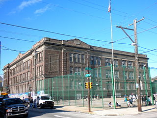
Vare-Washington School, is a K-8 school in South Philadelphia, Pennsylvania, United States. It is a part of the School District of Philadelphia. It occupies the former George Washington School building in the Dickinson Narrows neighborhood, in proximity to Southwark.

Dickinson Square West, Philadelphia is a neighborhood in South Philadelphia bordered by neighborhoods Queen Village to the north, Whitman to the south, Pennsport to the east and Passyunk Square and East Passyunk Crossing to the west. The neighborhood was previously referred to as "Dickinson Narrows", but was officially reestablished as "Dickinson Square West" in 2013 by the Registered Community Organization, Dickinson Square West Civic Association, located within its boundaries. In October, 2018, The Dickinson Square West Civic Association passed an amendment to expand the southern boundary from Mifflin Street to Snyder Ave

Abigail Vare School is a former school building located in the Pennsport neighborhood of Philadelphia, Pennsylvania. It is located across from Dickinson Square Park.


