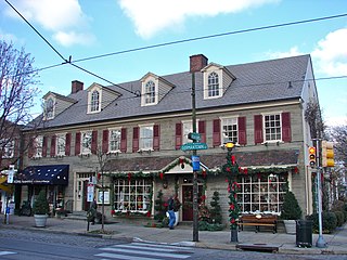
Chestnut Hill is a neighborhood in the Northwest Philadelphia section of Philadelphia, Pennsylvania, United States. It is known for the high incomes of its residents and high real estate values, as well as its private schools.

Merion Station, also known as Merion, is an unincorporated community in Montgomery County, Pennsylvania. It borders Philadelphia to its west and is one of the communities that make up the Philadelphia Main Line. Merion Station is part of Lower Merion Township, Montgomery County. The community is known for its grand mansions and for the wealth of its residents.

Hunting Park is a neighborhood in the North Philadelphia section of the United States city of Philadelphia, Pennsylvania.

South Philadelphia, nicknamed South Philly, is the section of Philadelphia bounded by South Street to the north, the Delaware River to the east and south, and the Schuylkill River to the west. A diverse working-class community of many neighborhoods, South Philadelphia is well-known for its large Italian-American population, but it also contains large Asian American, Irish-American, African-American, and Latino populations.

Kensington, colloquially known locally as “Kenzo,” is a neighborhood in Philadelphia that belongs to or divides Lower Northeast and North Philadelphia. As with all neighborhoods in the city, the lack of any official designation means the boundaries of the area vary between sources over time and are disputed among locals. Kensington, as most long-term residents view it, refers generally to the area consisting of Kensington, East, or Lower Kensington, West Kensington, and Harrowgate. The adjacent Fairhill and Norris Square neighborhoods are more separate but may be included in Kensington; Fishtown and South (Olde) Kensington were previously included but have developed new identities with gentrification. The most conservative boundaries of the neighborhood, shown in the map below, are Front Street and 5th Street to the west, the Amtrak train tracks to the North, Trenton Avenue, the Trenton Avenue train tracks, and Frankford Avenue to the east, and Cecil B. Moore Avenue to the south.
West Oak Lane is a neighborhood in the Northwest Philadelphia, Pennsylvania, United States. The neighborhood was developed primarily between the early 1920s and late 1930s, with the areas near to Cedarbrook constructed after World War II. At the northeast corner of Limekiln Pike and Washington Lane was the site of the Cedar Park Inn, a historic tavern built in the early 19th century, which was torn down sometime after 1931 as the neighborhood was being fully developed.

Rhawnhurst is a residential neighborhood in the Northeast section of Philadelphia, Pennsylvania, United States, named for George and William Rhawn by area real estate developers. Roughly bordered by Cottman Avenue to the south, Pennway Street to the west, the Pennypack Creek to the north, and Roosevelt Boulevard to the east, Rhawnhurst encompasses ZIP codes 19152 and part of ZIP code 19111. The geographic center of Rhawnhurst is at the intersection of Castor Avenue and Rhawn Street.

The Bustleton section of Northeast Philadelphia, United States is located in the Far Northeast, north of Rhawnhurst and Fox Chase and south of Somerton; sitting between Roosevelt Boulevard to the east, the city boundary to the west, Red Lion Road to the north, and Pennypack Park to the south, it is centered at the intersection of Grant Avenue and Bustleton Avenue (PA-532) and is completely included in the 19115 postal ZIP code.
Queen Village is a residential neighborhood of Philadelphia, Pennsylvania, United States that lies along the eastern edge of the city in South Philadelphia. It shares boundaries with Society Hill to the north, Bella Vista to the west and Pennsport to the south. Street boundaries are the south side of Lombard Street to the north side of Washington Avenue, the Delaware River to 6th Street, encompassing two principal commercial corridors, South Street and Fabric Row on 4th Street.

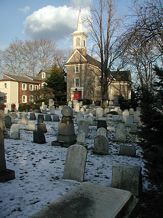
Bridesburg is the northernmost neighborhood in the River Wards section of Philadelphia, Pennsylvania, United States. Bridesburg is an historically German and Irish community, with a significant community of Polish immigrants who arrived mostly in the early- to mid-twentieth century. The community is home to two Catholic churches: All Saints Church, designed by Edwin Forrest Durang, built in 1889; and Saint John Cantius Church, built in 1898 in Polish Cathedral style.
Logan is a neighborhood in the upper North Philadelphia section of the city of Philadelphia, in the U.S. state of Pennsylvania. The majority of the neighborhood falls within the 19141 zip code, but some of it falls within 19140. The neighborhood is sometimes confused with the Olney neighborhood of Philadelphia. Olney Avenue extends from both the Olney and Logan neighborhoods of the city. The Olney Transportation Center is located in Logan.

Southwark was originally the Southwark District, a colonial-era municipality in Philadelphia County, Pennsylvania, United States. Today, it is a neighborhood in the South Philadelphia section of Philadelphia, Pennsylvania. Because of its location south of the early Philadelphia, the name was adopted in allusion to the borough of Southwark in the county of London, England, just south of the city of London.

Spring Garden is a neighborhood in central Philadelphia, Pennsylvania, United States, bordering Center City on the north. Spring Garden is a neighborhood that combines diverse residential neighborhoods and significant cultural attractions. The residential areas on the north side of the neighborhood are composed mostly of brick and brownstone three-story townhouses built during the mid-to-late 19th century. The houses include townhouses in the Italianate style, Second Empire, Queen Anne, and Venetian Gothic. Many streets include "terraced" set ups, which include a small gardened plot, often raised, in front of the house. The residential areas to the south are dominated by taller, multi-family buildings built during the 20th century. The museum area, also to the south of Spring Garden Street, includes the Rodin Museum, the Central Library of Philadelphia, and the Barnes Museum. Before consolidation of Philadelphia, Spring Garden was a district of Philadelphia County.
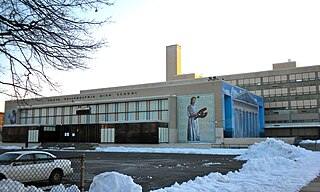
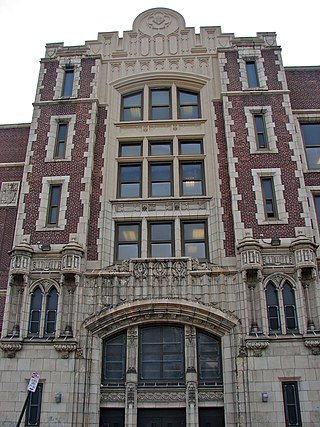
South Philadelphia High School is a public secondary high school located in the Lower Moyamensing neighborhood of South Philadelphia, at the intersection of Broad Street and Snyder Avenue.
Whitman is a neighborhood in the South Philadelphia section of Philadelphia, Pennsylvania, United States. It is bounded on the west by Sixth Street, on the east by Front Street, on the south by Bigler Street, and on the north by Snyder Avenue. The name "Whitman" was adopted when the nearby Walt Whitman Bridge was being constructed in the 1950s. In 2015, Whitman and nearby South Philadelphia neighborhoods were named by Philadelphia Magazine as one of the safest and most family-friendly neighborhoods in Philadelphia.
Newbold is a neighborhood in South Philadelphia, Pennsylvania, United States. Its boundaries are Broad Street on the east, 18th Street on the west, Washington Avenue on the north, and Passyunk Avenue on the south.

East Passyunk Crossing is a neighborhood in South Philadelphia, Pennsylvania, United States. Its location is considered to be from Tasker Street to Snyder Avenue and Broad Street to 6th Street.

Passyunk Square is a neighborhood in South Philadelphia bounded by Broad Street to the west, 6th Street to the east, Tasker Street to the south and Washington Avenue to the north. Passyunk Square is bordered by the Bella Vista, Hawthorne, Central South Philadelphia, Wharton, and Point Breeze neighborhoods. The neighborhood got its Lenape name from the 1800s Passyunk Township, Pennsylvania which named Passyunk Square Park, located between 12th, 13th, Reed and Wharton Streets. The park was eventually renamed Columbus Square Park, and subsequently the neighborhood became known as Columbus Square. Sue Montella, Geoff DiMasi, and a group of neighbors revived the Passyunk Square name when forming the Passyunk Square Civic Association in 2003.
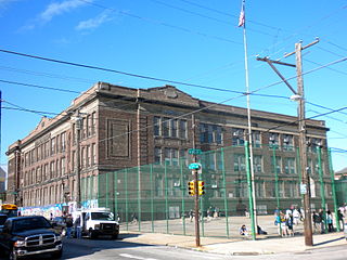
Southwark School is a public K-8 school located in the Central South Philadelphia neighborhood of Philadelphia, Pennsylvania. It is a part of Philadelphia Public Schools.

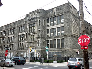
Francis Scott Key School is a public elementary school located in the Central South Philadelphia neighborhood of Philadelphia, Pennsylvania. It is a part of the School District of Philadelphia.

