Kingsessing is a neighborhood in the Southwest section of Philadelphia, Pennsylvania, United States. On the west side of the Schuylkill River, it is next to the neighborhoods of Cedar Park, Southwest Schuylkill, and Mount Moriah, as well as the borough of Yeadon in Delaware County. It is roughly bounded by 53rd Street to the northeast, Baltimore Avenue to the northwest, Cobbs Creek and 60th Street to the southwest, and Woodland Avenue to the southeast.
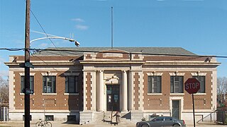
Frankford is a neighborhood in the Northeast section of Philadelphia situated about six miles (10 km) northeast of Center City. Although its borders are vaguely defined, the neighborhood is bounded roughly by the original course of Frankford Creek on the south to Castor Avenue on the northwest and southwest, to Cheltenham Avenue on the north, and to Aramingo Avenue and I-95 on the east. [source: GoogleMaps] Adjacent neighborhoods are Bridesburg, Juniata, Northwood, Summerdale, and Wissinoming.
Byberry is a neighborhood in the far northeast section of Philadelphia, in the U.S. state of Pennsylvania. Originally it was incorporated as the Township of Byberry and was the northeasternmost municipality of Philadelphia County before the City and County were consolidated in 1854. Its approximate boundaries are the Poquessing Creek to the north, Woodhaven Road to the south, the Roosevelt Boulevard to the west, and Thornton Road to the east.
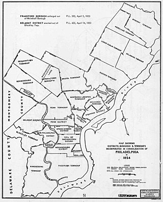
The Act of Consolidation, more formally known as the act of February 2, 1854, is legislation of the Pennsylvania General Assembly that created the consolidated City and County of Philadelphia, expanding the city's territory to the entirety of Philadelphia County and dissolving the other municipal authorities in the county. The law was enacted by the General Assembly and approved February 2, 1854, by Governor William Bigler. This act consolidated all remaining townships, districts, and boroughs within the County of Philadelphia, dissolving their governmental structures and bringing all municipal authority within the county under the auspices of the Philadelphia government. Additionally, any unincorporated areas were included in the consolidation. The consolidation was drafted to help combat lawlessness that the many local governments could not handle separately and to bring in much-needed tax revenue for the State.

Frankford Creek is a minor tributary of the Delaware River in southeast Pennsylvania. It derived its name from the nearby town of Frankford, Philadelphia County. The stream originates as Tookany Creek at Hill Crest in Cheltenham Township and meanders eastward, then southeastward, throughout Cheltenham Township, until a sharp bend near the Philadelphia border at Lawncrest, where the place names Toxony and Tookany were used in historic times; the stream is still known as Tookany Creek in this region, where it flows southwest. Turning south into Philadelphia at the crotch of Philadelphia's V-shaped border, the creek is called Tacony Creek; from here southward, it is considered the informal boundary separating Northeast Philadelphia from the rest of the city. The Philadelphia neighborhoods of Olney and Feltonville lie on the western side of the stream in this area while Northwood, Lawncrest, Summerdale, and Frankford lie on the eastern side. It continues to be called the Tacony at least until the smaller Wingohocking Creek merges with it in Juniata Park, within the city-owned golf course. Beyond Castor Avenue it is known as Frankford Creek until the stream's confluence with the Delaware River in the Bridesburg neighborhood of Philadelphia. The section of stream known as Frankford Creek is 3.1 miles (5.0 km) long, and the upstream section known as Tacony Creek, from Hill Crest, is 11.1 miles (17.9 km) long.

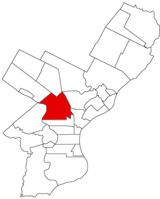
Moyamensing is an area of Philadelphia established as a Moyamensing Township during British colonial rule on the fast land of the Neck, lying between Passyunk and Wicaco. It was incorporated into Philadelphia County, Pennsylvania, United States and today encompasses several neighborhoods along the Moyamensing Avenue corridor in the South Philadelphia section of Philadelphia.

The Connecting Railway was a subsidiary of the Pennsylvania Railroad, incorporated to build a connection between the Philadelphia and Trenton Railroad and the PRR in the city of Philadelphia.
Northern Liberties Township is a defunct township that was located in Philadelphia County, Pennsylvania, United States. The township ceased to exist and was incorporated into the City of Philadelphia after the passage of the Act of Consolidation, 1854.
Aramingo Borough is a defunct borough that was located in Philadelphia County, Pennsylvania, United States. The borough ceased to exist and was incorporated into the City of Philadelphia following the passage of the Act of Consolidation, 1854.

Blockley Township is a defunct township that was located in Philadelphia County, Pennsylvania, United States. Incorporated in 1704, the township was incorporated into the City of Philadelphia under the 1854 Act of Consolidation.
Bristol Township is a defunct township that was located in Philadelphia County, Pennsylvania, United States. The township ceased to exist and was incorporated into the City of Philadelphia following the passage of the Act of Consolidation, 1854. It is the modern day Olney-Oak Lane Planning Analysis Section, though with a slight difference in the southern border. It is in present-day North Philadelphia, although Olney-Oak Lane is sometimes considered to be separate from North Philadelphia entirely because of their unique architecture, culture and differing patterns of development.
Delaware Township is a defunct township that was located in Philadelphia County, Pennsylvania, United States. The borough ceased to exist and was incorporated into the City of Philadelphia following the passage of the Act of Consolidation, 1854.
Germantown Township, also known as German Township, is a defunct township that was located in Philadelphia County, Pennsylvania, United States. The municipality ceased to exist and was incorporated into the City of Philadelphia following the passage of the Act of Consolidation, 1854.
Moreland Township, is a defunct township that was located in Philadelphia County, Pennsylvania, United States.

Penn District is a defunct district that was located in Philadelphia County, Pennsylvania, United States. The district ceased to exist and was incorporated into the City of Philadelphia following the passage of the Act of Consolidation, 1854.
Penn Township is a defunct township that was located in Philadelphia County, Pennsylvania, United States. The township ceased to exist and was incorporated into the City of Philadelphia following the passage of the Act of Consolidation, 1854.

Richmond District, also known as Port Richmond District, is a defunct district that was located in Philadelphia County, Pennsylvania, United States. The district ceased to exist and was incorporated into the City of Philadelphia following the passage of the Act of Consolidation, 1854.
Whitehall Borough is a defunct borough that was located in Philadelphia County, Pennsylvania, United States. The borough ceased to exist when it was incorporated into the City of Philadelphia on the passage of the Act of Consolidation, 1854.
Lower Dublin Township, also known as Dublin Township, is a defunct township that was located in Philadelphia County, Pennsylvania, United States. The township ceased to exist and was incorporated into the City of Philadelphia following the passage of the Act of Consolidation, 1854.

U.S. Route 13 (US 13) is a United States Numbered Highway running from Fayetteville, North Carolina, north to Morrisville, Pennsylvania. The route runs for 49.359 miles (79.436 km) through the Delaware Valley in the U.S. state of Pennsylvania. The route enters the state from Delaware in Marcus Hook, Delaware County. It continues northeast through Delaware County, passing through the city of Chester before heading through suburban areas along Chester Pike to Darby. US 13 enters the city of Philadelphia on Baltimore Avenue and runs through West Philadelphia to University City, where it turns north along several city streets before heading east across the Schuylkill River along Girard Avenue. The route turns north and heads to North Philadelphia, where it runs northeast along Hunting Park Avenue. US 13 becomes concurrent with US 1 on Roosevelt Boulevard, continuing into Northeast Philadelphia. US 13 splits southeast on a one-way pair of streets before heading northeast out of the city on Frankford Avenue. The route continues into Bucks County as Bristol Pike, heading northeast to Bristol, where it turns into a divided highway. US 13 becomes a freeway in Tullytown and continues north to its terminus at US 1 in Falls Township, near Morrisville. US 13 roughly parallels Interstate 95 (I-95) through its course in Pennsylvania.
