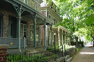
Powelton Village is a neighborhood of mostly Victorian, mostly twin homes in the West Philadelphia section of Philadelphia, Pennsylvania. It is a national historic district that is part of University City. Powelton Village extends north from Market Street to Spring Garden Street, east to 32nd Street, west to 40th and Spring Garden Streets, and to 44th and Market Streets.

Fishtown is a neighborhood in the River Wards section of Philadelphia, Pennsylvania, United States. Located northeast of Center City Philadelphia, its borders are somewhat disputed today due to many factors, but are roughly defined by the triangle created by the Delaware River, Front Street, and York Street. Some newer residents expand the area to Lehigh Avenue to the northeast, while some older residents shrink the area to Norris Street. It is served by the Market–Frankford Line rapid transit subway/elevated line of the SEPTA system. Fishtown was a largely working class Irish Catholic neighborhood, but has recently seen a large influx of young urban professionals and gentrification.

Fairmount is a neighborhood within Lower North Philadelphia, Pennsylvania, United States. Its boundaries are north of Fairmount Avenue, west of Corinthian Avenue, south of Girard Avenue and east of The Schuylkill River. While this may be the most accurate demarcation, the area's boundaries fluctuate depending how the neighborhood is defined. Several other neighborhoods near Fairmount are sometimes also collectively called Fairmount, including: Spring Garden, Franklintown and Francisville. Fairmount and neighboring Spring Garden are commonly referred to as the "Art Museum Area," for their proximity to and association with the Philadelphia Museum of Art. Fairmount is also the location of the Eastern State Penitentiary.

Northern Liberties is a neighborhood in Philadelphia, Pennsylvania, United States. It is north of Center City along the Delaware River. Prior to its incorporation into Philadelphia in 1854, it was among the top 10 largest cities in the U.S. in every census from 1790 to 1850. It was a major manufacturing area that attracted many European immigrants in the late 19th and early 20th centuries. In the early 21st century, it has attracted many young professionals and new commercial and residential development

Strawberry Mansion is a neighborhood in the U.S. city of Philadelphia, Pennsylvania, located east of Fairmount Park in North Philadelphia. The neighborhood is bounded by 33rd Street to the west, 29th Street to the east, Lehigh Avenue to the north, and Oxford Street to the south. As of the 2000 census, the neighborhood had a population of 22,562. It is often associated with the historic house of the same name, Historic Strawberry Mansion, located adjacent to the neighborhood and generally thought to be the source of the community's name.

North Philadelphia, nicknamed North Philly, is a section of Philadelphia, Pennsylvania. It is immediately north of Center City. Though the full extent of the region is somewhat vague, "North Philadelphia" is regarded as everything north of either Vine Street or Spring Garden Street, between Northwest Philadelphia and Northeast Philadelphia. It is bordered to the north by Olney Ave along Broad Street, Spring Garden Street to the south, 35th Street to the west and Adams Avenue to the east. The Philadelphia Police Department patrols five districts located within North Philadelphia: the 22nd, 25th, 26th, 35th and 39th districts. There are thirteen ZIP codes for North Philadelphia: 19120, 19121, 19122, 19123, 19125, 19126, 19130, 19132, 19133, 19134, 19137, 19140 and 19141.
Sharswood is a small neighborhood in the North Philadelphia section of the city of Philadelphia, Pennsylvania in the United States. It is located to the east of Brewerytown, north of Girard College, west of Ridge Avenue, east of 24th Street and south of Cecil B. Moore Avenue. It is often grouped with Brewerytown, as in the Brewerytown-Sharswood Community Civic Association, and the Brewerytown-Sharswood NTI Planning Area.

Lower North Philadelphia is a section of Philadelphia, Pennsylvania, that is immediately north of Center City and below Upper North Philadelphia and can be described as a section of Philadelphia that was designated as a "Model City" target, that has overcome poverty and blight through key developments and a recipient of a federal funded program in 1966 to improve the neighborhood and extend the Center City district north of City Hall. It also contains the Lower North Philadelphia Speculative Housing Historic District along Cecil B. Moore Avenue.

Carroll Park is a neighborhood in West Philadelphia, Pennsylvania, United States. Its boundaries are Lansdowne Avenue to the north, West Girard Avenue to the south, North 63rd Street to the west, and North 52nd Street to the east. Along major streets of the neighborhood, the Carroll Park Community Council, Inc. has placed banners that say “Carroll Park: Where our neighbors become friends.” The 10 trolley runs along Lansdowne Avenue and the 15 trolley runs along Girard Avenue. There is a park by the name of Carroll Park between North 59th and North 58th Streets and West Thompson Street and West Girard Avenue. Carroll Park’s residents are primarily working-class and lower-income African-Americans.

Thomas Fitzsimons Junior High School, later The Young Men's Leadership School at Thomas E. FitzSimons High School, was a public secondary school that, in its final years, was a secondary school for boys. It was located at 2601 West Cumberland Street in Philadelphia, Pennsylvania, United States and was a part of the School District of Philadelphia. The school was named after Thomas FitzSimons, who was a signer of the Constitution of the United States.
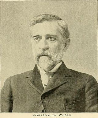
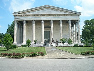
James Hamilton Windrim was a Philadelphia architect who specialized in public buildings, including the Masonic Temple in Philadelphia and the U.S. Treasury. A number the buildings he designed are on the National Historic Landmarks and/or the National Register of Historic Places, including the Masonic Temple in Philadelphia and the National Savings and Trust Company building in Washington, DC.

The Girard Avenue Bridge is an automobile and trolley bridge in Philadelphia, Pennsylvania, that carries Girard Avenue over the Schuylkill River. It connects the east and west sections of Fairmount Park, and the Brewerytown neighborhood with the Philadelphia Zoo. The current bridge is the third built on the site.
City Park Brewery, also known as the Louis Bergdoll Brewing Company, was a brewery in North Philadelphia, built in 1856. Several brewery buildings were added to the National Register of Historic Places in 1980 as a historic district. Louis J. Bergdoll started his brewery business in 1849 at 508 Vine Street, Philadelphia, and briefly operated as Bergdoll and Schemm. From 1856 until Charles Psotta's death in 1876, the firm was known as Bergdoll and Psotta. In 1856 the firm built new quarters on 28th and 29th Streets near Fairmount Park and the Schuylkill River. In 1881 the firm was incorporated as City Park Brewery. Louis Bergdoff died in 1894, but the firm continued to operate as a brewery until Prohibition in 1920, and then for a single year after the repeal of Prohibition, in 1934.
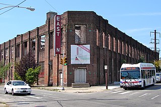
The American Railway Express Company Garage is a historic parking garage located at 3002-3028 Cecil B. Moore Ave. in the Strawberry Mansion neighborhood of north Philadelphia, Pennsylvania. It was designed by the firm Harris & Richards and constructed by the Robert E. Lamb Company in 1922 for developer John Presper Eckert, Sr.

The Neuweiler Brewery, also known as the Germania Brewery, is an historic brewery complex located in Allentown, Pennsylvania. Built between 1911 and 1913, the complex consists of the office building, brew house, stock house, pump house, wash house, chemistry lab building, boiler room, bottling house, garage, fermenting cellar, and smokestack with the name "Neuweiler" on it.
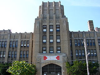
The Promise Academy at Roberts Vaux High School is an historic, American high school building that is located in the North Central neighborhood of Philadelphia, Pennsylvania.

Spring Garden School is a public K-8 school in the Poplar neighborhood of Philadelphia, Pennsylvania. It is a part of the School District of Philadelphia.
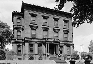
The Bergdoll Mansion is a historic house located in the Spring Garden neighborhood of Philadelphia. It was designed by architect James H. Windrim and built in 1886. It is in a Beaux Arts / Italianate style.

Girard Avenue is a major commercial and residential street in Philadelphia. For most of its length it runs east–west, but at Frankford Avenue it makes a 135-degree turn north. Parts of the road are signed as U.S. Route 13 and U.S. Route 30.


