
Skippack is a census-designated place (CDP) in Skippack Township, Montgomery County, Pennsylvania, United States. The population was 3,758 at the 2010 census.

Germantown is an area in Northwest Philadelphia, Pennsylvania. Founded by Palatine, Quaker, and Mennonite families in 1683 as an independent borough, it was absorbed into Philadelphia in 1854. The area, which is about six miles northwest from the city center, now consists of two neighborhoods: 'Germantown' and 'East Germantown'.

Mount Airy is a neighborhood of Northwest Philadelphia in the U.S. state of Pennsylvania.
Byberry is a neighborhood in the far northeast section of Philadelphia, in the U.S. state of Pennsylvania. Originally it was incorporated as the Township of Byberry and was the northeasternmost municipality of Philadelphia County before the City and County were consolidated in 1854. Its approximate boundaries are the Poquessing Creek to the north, Woodhaven Road to the south, the Roosevelt Boulevard to the west, and Thornton Road to the east.
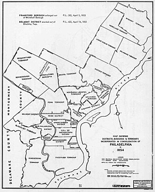
The Act of Consolidation, more formally known as the act of February 2, 1854, is legislation of the Pennsylvania General Assembly that created the consolidated City and County of Philadelphia, expanding the city's territory to the entirety of Philadelphia County and dissolving the other municipal authorities in the county. The law was enacted by the General Assembly and approved February 2, 1854, by Governor William Bigler. This act consolidated all remaining townships, districts, and boroughs within the County of Philadelphia, dissolving their governmental structures and bringing all municipal authority within the county under the auspices of the Philadelphia government. Additionally, any unincorporated areas were included in the consolidation. The consolidation was drafted to help combat lawlessness that the many local governments could not handle separately and to bring in much-needed tax revenue for the State.

Southwark was originally the Southwark District, a colonial-era municipality in Philadelphia County, Pennsylvania, United States. Today, it is a neighborhood in the South Philadelphia section of Philadelphia, Pennsylvania. Because of its location south of the early Philadelphia, the name was adopted in allusion to the borough of Southwark in the county of London, England, just south of the city of London.

Moyamensing is an area of Philadelphia established as a Moyamensing Township during British colonial rule on the fast land of the Neck, lying between Passyunk and Wicaco. It was incorporated into Philadelphia County, Pennsylvania, United States and today encompasses several neighborhoods along the Moyamensing Avenue corridor in the South Philadelphia section of Philadelphia.
Northern Liberties Township was a township that was located in Philadelphia County, Pennsylvania, United States. The township ceased to exist and was incorporated into the City of Philadelphia after the passage of the Act of Consolidation, 1854.
Bristol Township was a township that was located in Philadelphia County, Pennsylvania, United States. The township ceased to exist and was incorporated into the City of Philadelphia following the passage of the Act of Consolidation, 1854. It is the modern day Olney-Oak Lane Planning Analysis Section, though with a slight difference in the southern border. It is in present-day North Philadelphia, although Olney-Oak Lane is sometimes considered to be separate from North Philadelphia entirely because of their unique architecture, culture and differing patterns of development.
Moreland Township was a township that was located in Philadelphia County, Pennsylvania, United States.

Oxford Township was a township in Philadelphia County, Pennsylvania, United States. The township ceased to exist and was incorporated into the City of Philadelphia following the passage of the Act of Consolidation, 1854.

Penn District was a district located in Philadelphia County, Pennsylvania, United States. The district ceased to exist and was incorporated into the City of Philadelphia following the passage of the Act of Consolidation, 1854.
Penn Township was a township that was located in Philadelphia County, Pennsylvania, United States. The township ceased to exist and was incorporated into the City of Philadelphia following the passage of the Act of Consolidation, 1854.

Richmond District, also known as Port Richmond District, was a district that was located in Philadelphia County, Pennsylvania, United States. The district ceased to exist and was incorporated into the City of Philadelphia following the passage of the Act of Consolidation, 1854.
West Philadelphia Borough, also known as West Philadelphia District, was a borough that was located west of the Schuylkill River in Blockley Township, Philadelphia County, Pennsylvania, United States. The borough ceased to exist and was incorporated into the City of Philadelphia following the passage of the Act of Consolidation, 1854.
Lower Dublin Township, also known as Dublin Township, was a township that was located in Philadelphia County, Pennsylvania, United States. The township ceased to exist and was incorporated into the City of Philadelphia following the passage of the Act of Consolidation, 1854.

Cresheim Creek is a creek in southeastern Pennsylvania. Rising at Wyndmoor in Springfield Township, it runs about 2.7 miles (4.3 km) southwest, passing through part of Northwest Philadelphia and forming the boundary between Mount Airy and Chestnut Hill, before emptying into the Wissahickon Creek at Devil's Pool not far south of the Valley Green Inn.

Beggarstown or Bettelhausen was a small community that was located in the present day neighborhood of Mount Airy in Northwest Philadelphia in the U.S. state of Pennsylvania. It centered primarily along a stretch of relatively flat land along Germantown Avenue roughly between Upsal Street and Gorgas Lane.

The 1688 Germantown Quaker Petition Against Slavery was the first protest against enslavement of Africans made by a religious body in the Thirteen Colonies. Francis Daniel Pastorius authored the petition; he and three other Quakers living in Germantown, Pennsylvania, signed it on behalf of the Germantown Meeting of the Religious Society of Friends. Clearly a highly controversial document, Friends forwarded it up the hierarchical chain of their administrative structure—monthly, quarterly, and yearly meetings—without either approving or rejecting it. The petition effectively disappeared for 150 years into Philadelphia Yearly Meeting's capacious archives; but upon rediscovery in 1844 by Philadelphia antiquarian Nathan Kite, latter-day abolitionists published it in 1844 in The Friend, in support of their antislavery agitation.
Thones Dennis Kunders was an early settler of colonial Pennsylvania. He was born in Gladbach, Holy Roman Empire, and was a citizen of Krefeld. A dyer by trade, he was the head of one of the first 13 German families who sailed aboard the ship Concord to arrive in Philadelphia, Pennsylvania, on 6 October 1683, beginning the German immigration to America. Kunders later called himself Anthony Conrads and still later Cunard, and was also called Dennis Conrad. At Kunders's house in Germantown were held the first German religious services in America, attended by both Mennonites and Quakers, including Pennsylvania proprietor William Penn.

